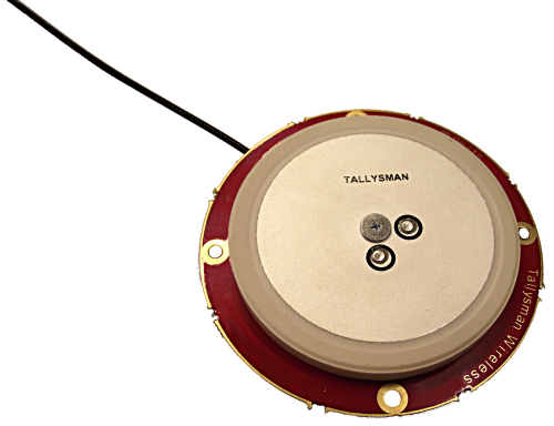
Tallysman, a manufacturer of economical high-performance GNSS antennas, has announced a new series of L1 band Accutenna wideband antennas for OEM applications. The antennas are offered in three formats for reception of GPS; GPS + GLONASS; or Galileo + GPS + GLONASS + BeiDou.
Each antenna type features Tallysman’s Accutenna technology, which provides high rejection of multi-path signals, with low axial ratios, and tight Phase Center Variations (PCV). Each is available with a brickwall pre-filter option to protect against saturation by high level sub-harmonic and L-Band signals.
Here are what each antenna in the new line covers:
The TW2106 is designed to receive GPS L1. TW2108 is the brick-wall pre-filtered version.
The TW2406 is designed to receive GPS + GLONASS. TW2408 is the brick-wall pre-filter version.
The TW2706 is designed to receive all of Galileo, BeiDou, GPS + GLONASS. TW2708 is the brick-wall pre-filter version.
The antenna PCBs are each 56 mm in diameter with four plated holes for secure mounting. They are available with a variety of connectors and custom cable lengths. The antennas can be custom tuned to ensure optimal performance within customers’ enclosures. All of them are REACH and ROHS compliant.
INTERGEO Announcement
At INTERGEO in Stuttgart, Tallysman will be announcing the availability of patented new GNSS antenna technology that it said is proving to:
Produce the lowest axial ratios from horizon to horizon through all azimuths and across all GNSS frequencies
Produce sub-millimetre Phase Centre Variation (PCV) through all elevations, all azimuths, and across all GNSS frequencies
Be lighter weight, smaller size, and more economical than other reference and geodetic antennas
Have the unique feature of having room within the antenna base to house customers’ circuitry.
Tallysman’s booth at INTERGEO will be in Hall E8, Booth 038. Follow GPS World on Twitter for the latest news from INTERGEO.
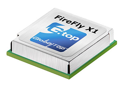
GlobalTop Technology has launched FireFly X1, a tiny Mediatek-based multi-GNSS module. With a compact size of 9.0 x 9.5 x 2.1 millimeters, it’s one of the smallest multi-GNSS modules in the industry, the company said.
“Compact size and low-power consumption will be the key [unique selling points] for the next generation of M2M Devices,” said Sam Khan, vice CEO of GlobalTop Technology. “After a comprehensive market study, we found that small size was one of the most important factors for companies when it came to GNSS module selection; other key factors included power consumption, TTFF, positioning accuracy, additional interfaces as well as quality and longevity of the module. I am proud to say that FireFly X1 delivers perfectly on all these criteria.”
According to Khan, the FireFly X1 was designed with “sophisticated engineering and an entirely new set of ultra-compact quality components to reach this miniature size, while adding more features and interfaces at the same time.” It uses the latest MT3333 engine with full support for GPS, QZSS, GLONASS and BeiDou, and is Galileo ready.
Tracking of up to two constellations simultaneously, and relying on the latest Mediatek firmware, it can provide positioning accuracy of up to 1.8 m CEP. Enabling EASY (self-generated orbit prediction), AGPS (ephermis file injection) and SBAS further enhances position accuracy.
Despite a smaller size, FireFly X1 incorporates a complete set of high-quality components, including TCXO, RTC Crystal, SMPS, SAW Filter and an additional LNA to provide reliable performance.
FireFly X1 combines miniature size with flexible multi-interface connectivity options such as SPI and I²C that can simplify a user’s design, and is designed for M2M devices relying on low-cost MCUs that offer limited serial interfaces.
GlobalTop’s free customization service further expands the capability of FireFly X1 with features such as custom NMEA output sentence, distance calculation, geofencing, magnetic variation and last- position-retention. Advanced users can also customize the basic parameters of the module, including baud rate, update rate, internal logger settings, DGPS mode, 3D Fix, 1 PPS timing, and more.
All modules are produced at GlobalTop’s in-house ISO 9001:2008 certified manufacturing facility, with 100 percent unit testing and complete quality control, allowing for a consistent annual yield rate of 99.98 percent.
Samples and Evaluation Kits for FireFly X1 are now available. Please contact us or your local distributor for more information.
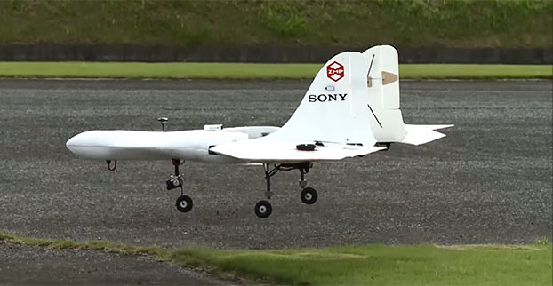
Sony is developing an unmanned aerial vehicle that lifts off and lands vertically like a helicopter (also known as a VTOL craft for vertical take-off and landing.) The VTOL drone is being developed with a Tokyo robotics firm under a collaborative company called Aerosense.
The drone can carry up to 22 pounds, fly continuously for two hours, and reach a speed of 106 miles per hour. Sony is developing it for business customers, who would use it for “measuring, surveying, observing and inspecting” as soon as next year, so it will likely carry different types of instruments, depending on the task a customer requires.
The video below shows a prototype flight on Monday.
Aerosense, created this month, is a joint venture between Sony and Tokyo-based startup ZMP Inc., which specializes in autopilot technology. The venture is part of Sony’s efforts to move beyond its core consumer products into enterprise markets. Aerosense will offer services such as inspecting aging infrastructure and surveying land that is difficult to access. The drones would be piloted automatically based on input from users about which areas they want surveyed.
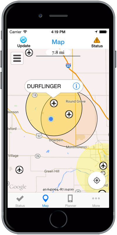
The Federal Aviation Administration (FAA) has released the beta version of a new smartphone application called B4UFLY for testing by up to 1,000 unmanned aircraft users.
The B4UFLY app, aimed primarily at model aircraft enthusiasts, is designed to give users information about restrictions or requirements in effect at their current or planned flight location. The FAA expects the beta test will yield valuable data on how well B4UFLY functions, as well as uncovering any software bugs.
FAA Administrator Michael Huerta first announced the initiative in May, asking for volunteers to test the app. The FAA has notified those who previously signed up and will be pushing the app to them directly in the coming days.
Many unmanned aircraft users today have little or no aviation experience, and some of them are flying where they could endanger manned aircraft. B4UFLY will give these flyers the tools and knowledge they need to operate safely.
Key features of the B4UFLY app include:
A clear “status” indicator that immediately informs operators about their current or planned location.
Information on the parameters that drive the status indicator.
A “Planner Mode” for future flights in different locations.
Informative, interactive maps with filtering options.
Links to other FAA UAS resources and regulatory information.
B4UFLY complements the Know Before You Fly educational campaign, which provides prospective UAS operators with information and guidance they need to fly safely and responsibly. The FAA is a partner in the effort with the Association for Unmanned Vehicle Systems International (AUVSI), Academy of Model Aeronautics (AMA), and the Small UAV Coalition.
Using the location services feature of a user’s smartphone, the app quickly determines restrictions or requirements in effect where they want to fly and gives the user a clear status icon. The status indicator function considers airspace, proximity to airports, temporary flight restrictions, current law and other FAA guidance and procedures.
Model aircraft operators who fly within five miles of an airport are required by law to notify the airport and the air traffic control tower — if there is one at the airport — prior to operating. The FAA is working on an electronic notification process to satisfy this requirement that will become part of a future version of B4UFLY. During the beta test, the FAA will collect user feedback and operational data and use it to develop this electronic notification process.
The beta test is expected to run for several months, after which the FAA plans to make B4UFLY available to the general public. The beta test will be for iOS devices only, but the FAA is working to ensure the full version will be compatible with Android devices as well.
Flying at Molly Caren Agricultural Center in the Ohio State project.
Clark State Community College in Springfield, Ohio, now includes flying unmanned aircraft systems (UAS) as part of its new precision agriculture program, according to the Ohio/Indiana UAS Center (UASC). The new program is designed to prepare students for employment with companies using geospatial technologies, including geographic information systems (GIS) and GPS applied to agricultural production or management activities, such as pest scouting, site-specific pesticide application, yield mapping, or variable-rate irrigation.
Clark State will process and analyze the UAS-collected data. Students will learn how fly and use UAS-gathered data to determine the overall health of crops and manage a range of farming issues, including how to spot early diseases, identify specific pest infestations, and determine fertilization requirement.
The Federal Aviation Administration (FAA) approved the Certificate of Authorization (COA) for UASC earlier this year. The center is working to expand the number of FAA-approved Certificates of Authority for research across Ohio, and operates 11 COAs in support of public entities and universities with an additional 17 COAs pending at the FAA.
Ohio State Sensor Research
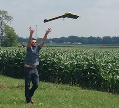
In another UASC project, UASC and The Ohio State University initiated regular flight operations in July at Molly Caren Agricultural Center to research various types of UAS sensors to improve agricultural productivity and enhance environmental management practices through improved nutrient use efficiency.
3D Aerial, a UAS business in Dayton, Ohio, pilots the small 1.5-lb fixed-wing aircraft for this project. Data gathered is part of a research and development effort focused on noninvasive assessment of crop health.
“This data will be analyzed and results will be used in support of research on cropping systems and assessment of environmental factors affecting crop growth,” said Scott Shearer, professor and chair of the Food, Agricultural and Biological Engineering at Ohio State. “In addition to precision agriculture experiments, this research will help enhance water quality by better understanding how best management practices may impact surface and ground water quality.”
The UAS market is projected to be an $82 billion industry with a potential to create approximately 100,000 jobs nationally over the next 10 years.
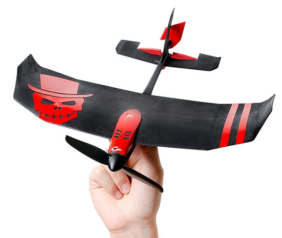
TobyRich has integrated OriginGPS’ Nano Hornet into a smartphone-controlled gaming drone line, to extend its range and enhance its directional capabilities. By leveraging the Nano Hornet, a tiny GPS module with an integrated antenna, TobyRich was able to design a smaller, sleeker form factor for its innovative drones while taking advantage of OriginGPS’ performance and low-power consumption features, according to TobyRich.
TobyRich, established in 2011 and with deep experience in designing smartphone-controlled drones, launched a Kickstarter campaign that will run until Aug. 28 to offer a new, more interactive experience for video gamers and drone enthusiasts across the globe.
The agile drones blend realistic flight maneuvers with innovative interactive gameplay and are designed to resemble an airplane rather than a quadcopter to extend flight time and carry more payload than traditional drones without compromising on functionality or performance. The drones can easily be controlled within a range of 90 meters via the tobyrich.red mobile app, which is available on iOS and Android.
TobyRich’s drones combine the immersive experience of video games with the exhilaration of real flight to unlock possibilities such as mid-air battles, races, stunts and other gaming scenarios, plus additional applications such as aerial photography and video, the company said. Single and multiplayer gaming modes enable video gamers to live out their flight fantasies with friends or solo. To meet users’ exact interests, several different versions are in development, including the basic tobyrich.vegas model, tobyrich.tokyo, which features a HD camera, and tobyrich.guru, a 4G/LTE-enabled drone.
With the help of OriginGPS, a TobyRich drone knows exactly where it is in relation to a user’s smart device, with unprecedented accuracy, allowing it to respond immediately and precisely to gesture controls or on-screen joysticks. OriginGPS’ location capabilities ensure that a drone will automatically return to its point of origin or a pre-programmed destination if it strays too far from its corresponding smart device or flight path, which reduces user frustration, minimizes human error and increases safety.
Measuring 10 by 10 millimeters, the OriginGPS Nano Hornet module powers TobyRich’s flight management system by achieving a rapid time to first fix (TTFF) of less than one second, with approximately 1 meter accuracy and -163 dBm tracking sensitivity, and it uses OriginGPS’ proprietary Noise Free Zone technology to increase sensitivity and minimize interference. It achieves a state of near continuous availability, while consuming microwatts of battery power, ensuring maximal power is devoted to increasing drone flight times. Because OriginGPS’ modules are complete, plug-and-play solutions, they significantly shorten time to market and dramatically reduce engineering risks, the companies said.
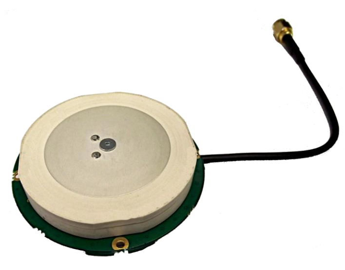
Tallysman, a manufacturer of high-performance GNSS antennas, has launched a higher gain dual-frequency embedded antenna: the TW3870E. The TW3870E antenna has a typical gain of 35 dB which is required by some GNSS receivers, such as Trimble’s BD9xx family of receivers.
The antenna is capable of receiving GPS L1/L2 and GLONASS G1/G2 signals. It employs Tallysman’s Accutenna technology, which can provide low axial ratios, high multi-path signal rejection, low noise, tight PCV and a phase linear response.
The TW3870E is 60 mm in diameter and has four drilled plated holes for secure mounting within customers’ products. The antenna can be custom tuned to ensure optimal performance. Custom cable lengths and connectors are also available.
The antenna is REACH and ROHS compliant.
Visit Tallysman’s booth at INTERGEO 2015, Hall E8, Booth 038 to learn more about the TW3870E and other Tallysman antennas.
The American Society for Photogrammetry and Remote Sensing (ASPRS) certification program has launched a Professional and Technologist LIDAR Certification with two certifications: the Certified Mapping Scientists, Lidar (CMS, Lidar) and the Certified Lidar Technologist (CLT).
The Certified Mapping Scientist, Lidar certification is described as:
A professional involved in lidar systems design and/or systems application of data acquisition and computer programs that allow for the utilization of spatially referenced lidar point clouds for solving user needs and analysis requirements. Responsibilities of the applicant should include management and supervision leading to the integration of data needs and the development of correspondence among, and the utilization of, various spatial systems of often-different generic origins that are used to solve requirements.
The Certified Lidar Technologist certification is described as:
A technician who performs routine Lidar collection support and first level data processing integrating established plans and procedures.
With this launch, the ASPRS education program expands to include nine certificate programs serving the geospatial industry. The ASPRS Certification program continues to offer the geospatial community the only accredited certifications in the industry, ASPRS said, and the program holds accreditation from the Council of Engineering and Scientific Specialty Boards (CESB).
Questions about the ASPRS certification programs can be directed to Jesse Winch, ASPRS Certification program manager, at [email protected] or by phone at 301-493-0290, x 101.
Four Ohio State University football fans trekked 19 miles to create the script “Ohio” logo on a GPS tracker. Even more impressive, they used Ohio Stadium as the dot on the “i,” similar to how the tuba player dots the “i” when the Ohio State marching band performs its famous “spell out” half-time routine.
Reddit user Orweezy and his friends used Google Maps to chart their spell out. “My coworker friends and [I] thought it would be cool to start off the football season by mapping and walking the Ohio Script this past weekend and using the stadium as the ‘I’ dotting. Would anyone be interested in doing this with us next year? Maybe even as a fund raising event for a good cause.”
He said the project took six-and-a-half hours, including a couple of bar stops.
Remote GeoSystems is now offering direct support in all of its LineVision cloud, server and desktop applications for video from the DJI Inspire 1 unmanned aerial vehicle. The new LineVision capability gives DJI Inspire 1 operators and pilots the ability to create and deliver interactive professional-grade video inspection and survey work products using GIS software such as Esri ArcGIS, Bing Maps and Google Earth.
DJI Inspire 1 users need to enable .SRT file logging while recording video during flight. Post-flight, LineVision allows users to load or upload the video and GPS track to a map. As the video plays, a cursor moves along the GPS track on the map, constantly indicating where and when the current video view was captured based on GPS data logged during the mission.
Users can geographically navigate the video recordings by clicking any of the points along the GPS track on a map. The video then automatically advances or reverses to that point in the video so that analysts and subject-matter experts can visually interpret what was recorded at that specific place and time.
In addition to FMV, LineVision features import/upload and “one-click” geo-referencing of nearly any kind of rich media including photos, audio and electronic documents or files such as PDF, Microsoft Office and CAD files.
LineVision features flexible mapping options allowing users to incorporate and “stream” background maps and data layers from your enterprise GIS and third-party map service providers. All these imported data types can be saved in a Remote GeoSystems .geoProject file for data portability and future analysis in LineVision software.
The Remote GeoSystems technology has been developed commercially and independent of defense programs, making it easier for non-military customers outside the U.S. and around the globe to acquire the applications and expertise without having to go through the often lengthy ITAR export process.
A new GNSS market research report by research firm RNCOS forecasts the global core GNSS market to grow at a Compound Annual Growth Rate (CAGR) of 9 percent during 2015-2020.
The GNSS industry includes technology that allows any user having a compatible device to determine their position, velocity and local time by processing signals from satellites in space. Signals include GPS, Galileo, GLONASS, BeiDou and regional SBAS. The GNSS market includes both products (receivers and devices) and services using GNSS-based positioning as a significant enabler.
In the latest research study “Global Navigation Satellite Systems Market Outlook 2020,” analysts identify and decipher the market dynamics in important segments, highlighting the areas offering promising possibilities for companies to boost their growth. The report studies the market by its major application and location-based services, transportation (further divided into road navigation, rail navigation, air navigation and marine navigation), surveying activities and agriculture.
The GNSS application market is further studied by region — North America, Europe, Asia-Pacific, and Rest of World. The report provides a complete overview of the GNSS market globally. All the current trends and drivers coupled with potential growth areas of the GNSS industry have been evaluated in the report. Furthermore, the report provides knowledge of opportunities in the industry for different companies in the “Opportunity Assessment” chapter.
Additionally, to provide an exhaustive knowledge of the prospects for GNSS players on the geographical front, the report provides a comprehensive knowledge of the 10 most worthwhile GNSS markets around the world: U.S., Canada, UK, France, Germany, Russia, Japan, China, South Korea and India. It includes information about the present state and future outlook of the LBS and telematics market in these countries, along with information about their personal navigation systems with the U.S.’s GPS, China’s BeiDou, Europe’s Galileo, Russia’s GLONASS, Japan’s QZSS and India’s IRNSS.
Finally, the study looks into the competitive landscape covering business overviews, key financials, product analyses, recent developments and strengths and weaknesses analyses of each of the players. All in all, the report is intended to help clients analyze the driving forces and understand the opportunities in the industry.