Category: Uncategorized

  • ION GNSS+ Product Showcase

    Skydel-gnss-simulator-W
    Skydel Solutions’ GNSS simulator.
    The Averna RP-6100 record-and-playback solution.
    The Averna RP-6100 record-and-playback solution.

    Record & Playback

    The Averna RP-6100 Multi-Channel RF Record & Playback for RF application testing allows users to tecord real-world signals such as GNSS, HD Radio, LTE and Wi-Fi — plus impairments — to significantly advance projects and harden product designs. Skydel Solutions’ GNSS simulator is an entirely software driven innovative and cost-effective simulator that works with the RP-6100, enabling users to test corner cases and future events with a real-time GNSS solution.

    Averna, www.averna.com; Skydel Solutions, www.skydelsolutions.com

    PCTEL's GEO-GNSS antennas.
    PCTEL’s GEO-GNSS antennas.

    Helix Antennas

    PCTEL’s GPS/GLONASS high-performance asset tracking and synchronization helix antennas are now available commercially. The antennas capture the frequencies needed for GPS, Galileo and GLONASS satellite reception. This cross-compatibility allows global OEMs to use one standard platform to serve both European and U.S. markets.

    PCTEL uses its proprietary filtering design to allow wideband coverage while achieving superior out-of-band rejection. With an IP67 rating, the small form-factor helix antennas will withstand harsh environments.

    PCTEL, www.pctel.com

    AsteRx-U dual antenna receiver
    AsteRx-U dual antenna receiver.

    Multi-Constellation Dual-Antenna Receivers

    AsteRx-U and AsteRx-U Marine multi-constellation dual-antenna receivers incorporate the latest GNSS tracking and positioning algorithms and interference mitigation. Machine-control users in the agricultural, construction, marine and mining industries benefit from a complete system with integrated UHF radio, Wi-Fi, USB, Bluetooth and cellular connectivity and a spectrum analyzer. All configurations can be done via the on-board web interface.

    The AsteRx-U has decimeter- and centimeter-level RTK positioning including TerraStar. The AsteRx-U Marine also supports Veripos PPP augmentation services.

    Septentrio, www.septentrio.com

    Syntony-RTG2-W
    The RTG2 constellation simulator by Syntony.

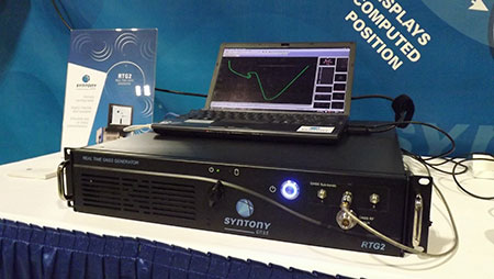
    Constellation Simulator

    The RTG2 is a GNSS constellation simulator that generates realistic GNSS RF signals, taking into account current and future GNSS constellations. RTG2 is able to entirely simulate one or many constellations (GPS, Galileo, etc.) including satellite-based augmentation systems such as WAAS and EGNOS.

    The generator is entirely configurable (troposphere and ionosphere effects, simulated receiver trajectory, etc.) through a user-friendly interface accessible on a separate PC through Ethernet. RTG2 is highly flexible and scalable, offering hardware and software upgrades for capability extensions.

    Syntony GNSS, www.syntony.fr

    Telit's Jupiter SE873 GNSS receiver with flash memory.
    Telit’s Jupiter SE873 GNSS receiver with flash memory.

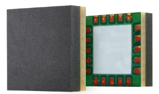
    GNSS Receiver with Flash Memory

    The Jupiter SE873 GNSS receiver is a complete multi-constellation position, velocity and time engine that delivers versatile performance in harsh environments. The 7 x 7 x 1.85 mm module has serial quad I/O flash memory, an integrated low noise amplifier, SAW filter, TXCO and real-time clock. The Jupiter SE873 supports Assisted GPS (both autonomous and server-based) plus SBAS, which improve time-to-first-fix and position accuracy. AGPS data is stored in flash memory and is available even after all power has been removed and then restored. This is especially important for battery-operated equipment.

    The SE873 supports the entire GNSS spectrum: GPS, GLONASS and BeiDou, and it is Galileo ready. It delivers simultaneous low-power tracking of GPS and GLONASS or GPS and BeiDou.

    Telit, www.telit.com

  • Track Hurricane Joaquin with Maps, Social Media

    Hurricane-Joaquin-Esri-O

    Esri is providing a continuously updated hurricane map that shows the projected paths, storm surge, weather warnings and precipitation of Hurricane Joaquin. In addition, the real-time effects of the storm can be seen via social media posts. The website, Hurricanes & Cyclones, is part of the Esri Disaster Response Program.

    The National Oceanic and Atmospheric Administration is offering updates through its National Hurricane Center.

    Hurricane Joaquin strengthened into a Category 4 storm on Thursday as it moved through the eastern Bahamas, and could grow more intense as it nears the U.S. East Coast.

  • The Business — October 2015

    The Business section from the October 2015 GPS World. Download the PDF.

    Includes:

    • INTERGEO’s Massive Marketplace
    • Antenova GNSS Antenna Integration
    • What Mattered Most at CTIA Super Mobility Week
    • UAV, Survey Markets Key for Maxtena Growth
    • Broadcom’s New Chip for Internet of Things
    • Autonomous Vehicles, Drones Next Big Thing for u-blox
    • PCTEST Expands Antenna Testing Capabilities with Rohde & Schwarz
    • Spirent Robust Framework Evaluates Threats to GNSS


  • Denver, FAA Partner on Drone Safety

    Denver International Airport and the Federal Aviation Administration (FAA) are partnering to raise awareness about safe unmanned aircraft operations.

    The agencies teamed up on a public service announcement that will run on the video towers in the airport’s main terminal. The PSA uses the “No Drone Zone” slogan to drive home the point that flying an unmanned aircraft near a manned aircraft is illegal and dangerous. It refers viewers to the FAA’s unmanned aircraft website and to the knowbeforeyoufly.org website for further information and guidance on flying unmanned aircraft safely and responsibly.

    The PSA will air all day today following its unveiling at an unmanned aircraft safety press event that the airport organized and hosted. After that, it will air for two weeks surrounding the winter holidays — a time when many people will be getting drones as gifts.

    Denver also will post the PSA on the airport website so it will reach travelers every day of the year.

    The FAA has partnered with leading unmanned aircraft industry and hobbyist groups in the Know Before You Fly education campaign, and the campaign materials are now featured in product packaging for several types of UAS.

  • Intergraph Government Solutions Wins USDA Contract Award

    ERDAS_Photogrammetry

    Intergraph Government Solutions (IGS) has been awarded a contract by the U.S. Department of Agriculture (USDA) U.S. Forest Service to provide image processing software across the U.S. Forest Service enterprise. IGS is a wholly-owned subsidiary of Intergraph Corporation, a Hexagon company serving the U.S. federal market.

    IGS will provide capabilities for core image processing and photogrammetry through Hexagon Geospatial’s Power Portfolio, including ERDAS IMAGINE for remote sensing and IMAGINE Photogrammetry. Integration of these products into the organization allows the U.S. Forest Service to perform mission-critical image processing and analysis on nearly 200 million acres of land for objectives such as forest restoration and emergency response to wildfires.

    “The U.S. Forest Service is a long-standing customer of IGS and Hexagon software. This purchase provides the agency with the most advanced geospatial technology for monitoring and managing national forest resources,” said Joe Fehrenbach, CEO and president of IGS.

    The result of a competitive best-value procurement, the award includes a base contract period of one year and an additional four option years. As part of the selection process, the U.S. Forest Service required live demonstrations of the proposed workflow technologies with government-provided datasets and rigorous requirements related to multiple areas of need in their business mission.

  • JAVAD GNSS 5 Hz “Beast Mode” RTK Base Station Corrections Reduce the Time to Acquire a Fix by 72 Percent

    by Matt Johnson

    In another industry first, JAVAD GNSS has added the ability to transmit and process RTK base station corrections at rates greater once per second (1 Hz). The current industry standard has been to transmit and process corrections once per second. The JAVAD GNSS RTK engineering team recently hypothesized that increasing the rate of corrections would reduce the time for their RTK systems to acquire fixed RTK solutions. Mathematically the time required to acquire a fix is inversely proportional to the rate of the corrections.

    Many existing RTK systems on the market have the ability to extrapolate 1 Hz corrections so that RTK positions can be computed at rates greater than 1 Hz. This innovation is advantageous with machine control applications where the GNSS antenna is in motion and it is desirable to know its position more than once per second. It, however, does not reduce the time required for the RTK engines to acquire fixed solutions. J-Field, JAVAD’s field software for the TRIUMPH-LS and Victor-LS, has RTK Verification and Validation features that reset the RTK engines to ensure a bad fix never gets accepted in areas under tree canopy and areas with high multipath. By reducing the time for the RTK engines to fix, RTK Verification and Validation can be completed much quicker and surveyors can collect points in locations that previously very difficult and time consuming.

    J-Field and the RTK firmware have been improved to allow corrections to be processed at 2 and 5 Hz. These corrections can be transmitted through Javad’s UHF and spread spectrum radios or through the internet with a TCP connection between the base station and rover. Those who have used the TRIUMPH-LS with 5 Hz corrections have described the system as operating in “Beast Mode” due to its much improved performance. In a recent test to quantify the improved performance with acquiring a fixed solution, a TRIUMPH-LS was setup to automatically collect 100 points in succession with correction rates of 1 Hz, 2 Hz and 5 Hz. RTK Verification was used to reset the RTK engines once and then collect 1 epoch after at least 4 of the 6 parallel RTK engines of the system have fixed, essentially measuring the time required for 4 of the RTK engines to fix. The test location was in an environment with some multipath and an approximately 75 percent open view of the sky.

    Photo: JAVAD GNSS


    With 2 Hz corrections, the average time for 4 engines to fix was reduced by 46 percent to 6.7 seconds compared to 12.5 seconds with 1 Hz corrections.   With 5 Hz corrections it was reduced by 72 percent to 3.5 seconds. The JAVAD RTK engineering team currently has further plans to improve the RTK firmware to allow correction rates even greater than 5 Hz to be used and tested. With this and JAVAD’s continued commitment to develop new and innovative features, the limits and applications for survey grade GNSS receivers continues to expand.

  • Unicore Releases GNSS High-Precision Board

    Unicore has released the UB380 GPS/GLONASSS/BDS high-precision board at ION GNSS+ 2015, held this week in Tampa, Fla.

    UB380 is a multi-GNSS receiver that supports GPS, GLONASS and BDS. It is based on Unicore’s mature multi-GNSS system on chip (SoC). UB380 is designed for high-precision positioning, navigation and GBAS applications.

    UB380 can track GPS L1, L2, L5; GLONASS L1, L2; and BDS B1,B2, B3 (support) — the support of GPS L2P, L2C can satisfy the high-precision requirements of GBAS reference station equipment.

    With the latest tri-frequency RTK engine, UB380 can process tri-frequency of BDS and GPS, and the dual-frequency of GLONASS observation data, which can significantly reduce initialization time, improve position accuracy, and enhance reliability in difficult environments such as in urban canyons and under tree canopy, as well as make long baseline RTK possible.

    Source: GPS world staff
    The UR380 GNSS receiver with UB380 inside.

    UB380 is compatible with industry-standard GNSS boards in size, interfaces and electrical standards.

    Features of UB380:

    • 384 channels, support for BDS B1/B2/B3 + GPS L1/L2/L5 + GLONASS L1/L2
    • Better than 1-mm carrier-phase precision
    • Centimeter-level high-precision RTK positioning
    • Better than 0.2° heading accuracy
    • Compatible with industry standard GNSS boards
  • Topcon Releases Three New GLS Laser Scanners

    GLS-2000_Series_Models-W

    Topcon Positioning Group is releasing three new models to the GLS line of laser scanners — the GLS-2000S, GLS-2000M and GLS-2000L. The scanners are designed to capture data based on the measurement range needs of specific applications.

    “These new GLS-2000 scanners offer purposeful solutions and versatility that comes from the multiple measurement modes with each model,” said Charles Rihner, vice president for the Topcon GeoPositioning Solutions Group. “The S model is optimized for short-range applications, while the M and L models are perfect for medium and long-range measurement fields, respectively.”

    Using Topcon Precise Scan Technology II, the GLS-2000 models are designed to emit pulse signals three times faster than earlier GLS systems. “Using faster pulse signals enables timing to be detected more precisely, which results in reduced noise and higher-accuracy data,” Rihner said.

    Additionally, the systems feature dual 5MP cameras, including one with a 170-degree wide-angle lens for high-speed imaging, as well as an 8.9-degree telephoto camera that is coaxial with the measuring axis.

    When paired with Topcon ScanMaster software, the models provide complete systems for capturing and processing 3D point cloud data.

    Topcon is exhibiting this week at the INTERGEO trade show, in Hall 6, Booth A6.002.

  • New Spirent Test Framework Evaluates Threats to GPS, GNSS

    New Spirent Test Framework Evaluates Threats to GPS, GNSS

    GNSS Interference Detector System.
    GNSS Interference Detector System.

    Spirent Communications has announced a Robust PNT Test Framework that evaluates GPS and GNSS security vulnerabilities for positioning, navigation and timing (PNT) systems.

    Threats to GNSS and related PNT applications are more orchestrated and coordinated, with the motivation to disrupt or cause financial loss. The technology to disrupt GPS has also become much more accessible, resulting in GPS vulnerability gaining attention at hacker conventions.

    Spirent’s GSS100D Detector, developed in collaboration with Nottingham Scientific Ltd, enables detection, characterization and analysis of real GNSS threats.
    Spirent’s GSS100D Detector, developed in collaboration with Nottingham Scientific Ltd, enables detection, characterization and analysis of real GNSS threats.

    The Robust PNT Test Framework will be used by technology, system and application developers where PNT is critical. Spirent’s framework enables threats to be detected in the field, taken into the lab and re-synthesized along with GPS and other GNSS signals. In addition, Spirent’s threat intelligence library of actual and typical threats provides a wide range of GNSS segment errors and spoofing attacks, as well as space weather and other vulnerabilities for preventive troubleshooting.

    “Spirent wants to move beyond talking about the increase of GNSS vulnerabilities and offer a pragmatic approach to enable informed decision making when it comes to evaluating the impact of vulnerabilities,” said John Pottle, marketing director of Spirent’s Positioning Technology Division. “Through our Robust PNT Test Framework Spirent is pulling everything together to enable users to readily audit systems and take practical steps to improve resilience.”

    Spirent’s New GSS100D Detector, developed in collaboration with Nottingham Scientific Ltd., enables detection, characterization and analysis of real GNSS threats.

    The Robust PNT test framework is being demonstrated on the Spirent booth at ION GNSS+ 2015 this week.

    Spirent’s Robust PNT Test Framework.
    Spirent’s Robust PNT Test Framework.
  • Live updates from Intergeo 2015

    intergeo15_pano_WGPS World staff is reporting from Intergeo Sept. 15–17. The massive trade show, held this year in Stuttgart, Germany, is considered the world’s leading conference trade fair for geodesy, geoinformation and land management. With more than 16,000 visitors from 80 countries, it is one of the key platforms for industry dialogue.

    Editorial staff members attending include GPS World Survey/GIS Editor Eric Gakstatter and Senior Digital Editor Joelle Harms. Both are accepting meeting invitations for companies interested in discussing their products and services. Contact [email protected] for more information.

    BLOG

    First Day at INTERGEO: UAVs and RTK GNSS Receivers, by Eric Gakstatter (9/15)

    NEWS

    Nikon-Trimble Introduces Updated Nikon Total Stations (9/15)

    Spectra Precision Introduces New and Enhanced Survey Solutions (9/15)

    Trimble Launches R2 GNSS Receiver at INTERGEO (9/15)

    Applanix Offers Entry-Level Georeferencing Solution for Airborne Mapping (9/15)

    senseFly eXom Drone Capable of Millimeter Accuracy (9/15)

    Topcon Releases Three New GLS Laser Scanners (9/15)

    Carlson SurvCE 5.0 Improvements on Display at INTERGEO (9/14)

    Septentrio Launches AsteRx-U and AsteRx-U Marine (9/14)

    Hemisphere GNSS’ Atlas Makes Trade Show Debut at INTERGEO (9/14)

    Tallysman Introduces VeraPhase 6000 High-Precision GNSS Antenna (9/10)

    Mobile Surveying Solutions from Teledyne Optech Shown at INTERGEO 2015 (9/9)

    SBG, Viametris Present 3D Indoor Scanning System at INTERGEO (9/8)

    YellowScan Lidar for UAVs Aided by Ellipse-E Inertial Navigation System (9/4)

    INTERGEO 2015: Stuttgart Moves Toward Smart City (9/3)

    JAVAD GNSS to Showcase New Technology at INTERGEO (9/1)

    Tallysman Introduces Wideband Embedded GNSS Antennas (9/1)

    Tallysman Launches Higher Gain Dual-Frequency Antenna (8/19)

    Satel Joins with Antenna Maker Welotec at INTERGEO (8/12)

    INTERGEO in Stuttgart Looks to Mapping’s Future (8/4)

    VIDEO PLAYLIST

    PHOTOS

    SOCIAL MEDIA

  • DJI Offers New Micro Cameras for UAVs

    The Inspire UAV in flight.
    The Inspire UAV in flight.

    DJI is offering two new cameras for its DJI Inspire 1 professional aerial camera platform.

    The new Zenmuse X5 is a commercially available micro four-thirds (M4/3) camera designed specifically for aerial use. With a large sensor, aerial image makers will be able to capture up to 13 stops of dynamic range, making it easy to capture high-resolution 16 megapixel photos or 4k, 24fps and 30fps videos in complex lighting environments.

    Zenmuse X5 users will have more options for capturing images in the sky through additional supported lenses and full wireless aperture and focus control. At the time of launch, the Zenmuse X5 will support four interchangeable lenses, including the DJI MFT 15mm f/1.7 ASPH lens, Panasonic Lumix 15mm G Leica DG Summilux f/1.7 ASPH lens, Olympus M.ZUIKO DIGITAL ED 12mm f/2.0 lens, and Olympus M.Zuiko 17mm f/1.8 lens. While the Zenmuse X5 is in flight, pilots can adjust both focus and aperture via the DJI GO app or through DJI’s previously announced Follow Focus system.

    The Zenmuse-X5 aerial camera.
    The Zenmuse-X5 aerial camera.

    The camera’s lightweight 340-gram (0.75-pound) body integrates with DJI’s signature three-axis Zenmuse gimbal technology, creating effortlessly smooth video and stabilized long-exposure photos (up to 8 seconds).

    “The professional applications of the Zenmuse X5 are almost endless,” said Eric Cheng, DJI’s director of Aerial Imaging. “In addition to shooting professional-quality photos and 4K video, the new camera can be used to create high-quality aerial maps and 3D models, and can also help industrial teams get even more detail from their aerial imaging pursuits, for example, in utility inspection using a drone.”

    DJI also announced the Zenmuse X5R camera, which shares the same sensor and lens compatibility with the X5, but records video both to an onboard microSD card as well as to a removable 512GB solid state disk (SSD) on the gimbal’s top plate. The Zenmuse X5R records CinemaDNG (RAW) video to the SSD, and opens up lossless 4k video recording in a compact form factor with video bitrates averaging 1.7 Gbps (with a maximum of 2.4 Gbps).

    The Zenmuse X5R also offers a brand-new D-LOG mode that offers a broader array of color correction options in post production.

    To support the management of Zenmuse X5R Cinema DNG files, DJI will release software to edit and convert RAW camera footage. CineLight, which will be available when the Zenmuse X5R camera is released later this year, simplifies users’ workflows by offering offline proxy editing before converting the CinemaDNG files to ProRes.

    “In order to achieve the quality of video produced by Zenmuse X5 and X5R, pilots used to have to spend many thousands of dollars for large, complicated aerial equipment,” said Frank Wang, DJI CEO and founder. “Now, pilots can simply mount the Zenmuse X5 series cameras to their Inspire 1, put on their props, get up in the air, and have full control of their shot while in flight. This saves valuable time on film sets and makes high quality imaging for industrial applications smaller, lighter and easier to manage.”

    By mounting a small, easy-to-install bracket, the Zenmuse X5 series cameras are fully compatible with existing DJI Inspire 1 platforms as an interchangeable option for the Inspire 1’s standard Zenmuse X3 camera.

    The Zenmuse X5 is available for pre-order at store.dji.com for $4,499 (€4,999), including a DJI Inspire 1 and DJI’s MFT 15mm F1.7 ASPH lens, and will begin shipping before the end of September. The Zenmuse X5R will be available in Q4 2015 for $7,999 (€8,799). Both can be purchased as stand alone cameras with, or without lens. More information can be found at dji.com.

  • Market Report Assesses U.S. GNSS Industry

    The United States GNSS Industry 2015 Market Research Report, now available from Wise Guy Reports, is a professional and in-depth study on the current state of the GNSS industry.

    The 316-page QYResearch Group report provides a basic overview of the industry including definitions, classifications, applications and industry chain structure. The GNSS market analysis is provided for the United States markets including development trends, competitive landscape analysis, and key regions development status.

    Development policies and plans are discussed as well as manufacturing processes and Bill of Materials cost structures are also analyzed. This report also states import/export consumption, supply and demand figures, cost, price, revenue and gross margins.

    The report focuses on leading industry players in the U.S., providing information such as company profiles, product picture and specification, capacity, production, price, cost, revenue and contact information. Upstream raw materials and equipment and downstream demand analysis is also carried out. The GNSS industry development trends and marketing channels are analyzed. Finally, the feasibility of new investment projects are assessed and overall research conclusions offered.

    With 335 tables and figures, the report provides key statistics on the state of the industry and is directed at companies and individuals interested in the market.