Fraunhofer IIS has opened paper submissions for The International Conference on Indoor Positioning and Indoor Navigation (IPIN) 2023, which takes place Sept. 25 -28 at the Nordostpark in Nuremberg, Germany.
The event is dedicated to indoor positioning, its applications and recent developments. The last decade has seen tremendous technical advances in indoor positioning. However, unlike the GNSS solutions established in the outdoor environment, there is not yet a technology that is affordable and accurate enough for the general market.
The potential applications of indoor localization are all-encompassing, from the home to vast public areas, from internet of things and personal devices, to monitoring applications.
The conference expects to attract up to 300 industrial and academic experts from the fields of computer science, electronics and surveying to address these challenges and the future of the industry.
To learn more about the conference and paper submissions, visit INIP-Confrence.org.
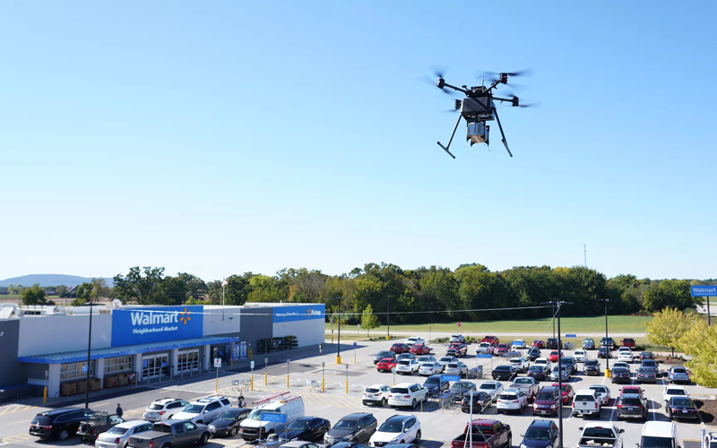
Two Walmart locations in Utah, one in Lindon and one in Herriman, are now providing UAV delivery for customers nearby. Walmart has UAV deliveries operated by DroneUp, Flytrex and Zipline at 36 stores in the United States.
For a $3.99 fee, customers within a mile of the stores can receive their groceries via UAVs. The two Walmart locations in Utah can deliver more than 120 times per day and each UAV can carry up to 10 pounds. The hubs for deliveries are in the parking lots of each Walmart location and are operated by Federal Aviation Administration-certified pilots.
Walmart is using UAV delivery in seven states, including Florida, Arizona, Texas, Utah, Virginia, North Carolina and Arkansas. The most common products delivered include ice cream, lemons, rotisserie chicken, Red Bull and paper towels, according to Walmart.
Walmart drone deliveries launched in October 2019 in Arkansas. In 2022, Walmart completed more than 6,000 deliveries across all 36 participating locations.
Autel Robotics has unveiled its EVO Max 4T UAV, an intelligent flight platform designed for enterprise and professional applications. The company made the announcement at CES 2023.
EVO Max 4T’s autonomous flight technology and artificial intelligence features give it self-reliance and navigation capabilities. It has omnidirectional obstacle avoidance and tri-anti-interference capability to ensure flight safety and stability in high-interference environments.
It is equipped with three high-quality cameras including a 48 MP telephoto camera, a 50 MP wide-angle camera and an infrared camera. The platform has a range of navigation and data-acquisition functions, including 3D flight routes, PinPoint Mode, Team Work, Polygon Mission, Waypoint Mission and Oblique Photography.
Autel Robotics also released the Dragonfish NEST and the EVO NEST. Dragonfish NEST is an automated electric vertical takeoff and landing (eVTOL) support system, with a range of up to 75 miles between units, and is suitable for long-range corridor inspections and large area coverage. EVO NEST is a base for automatic take-off, landing, charging and mission planning for EVO series UAVs. It is designed for all-weather operation and can be easily transported.
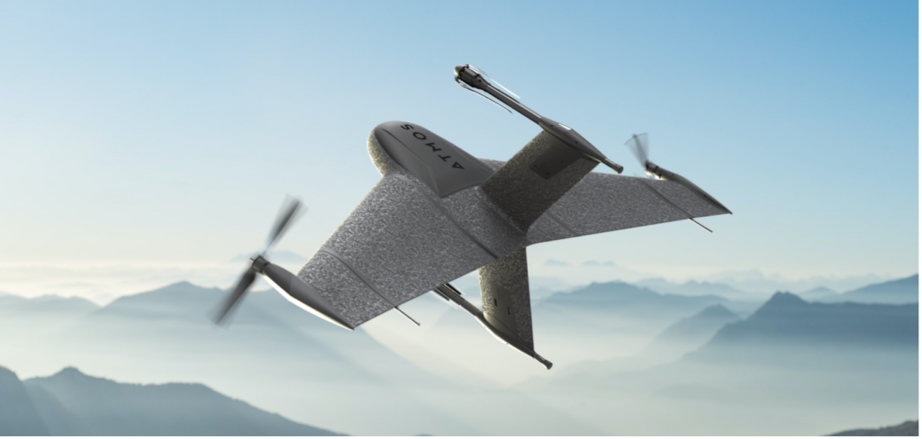
Atmos, a Dutch UAV manufacturer that develops high-end VTOL fixed-wing UAVs for mapping and surveying applications, expanded its global reseller network by signing a reseller agreement with Volatus Aerospace, a leader in commercial drones and UAV technology, in Canada.
Volatus will be responsible for the distribution of Marlyn Cobalt UAVs in Canada and will provide assistance and maintenance services to local UAV operators. The company brings extensive experience in aviation operations, safety, compliance and innovation to the evolving uncrewed aircraft market.
Marlyn Cobalt is the first fully autonomous hybrid (VTOL and fixed-wing) drone for mapping and surveying applications. With its patented design that combines the best of both worlds, Marlyn can take off vertically from anywhere and map fast and efficiently producing high-quality outputs for professional users. It is the only drone in its class that is built to perform even in harsh and windy conditions, while its easily swappable payloads provide operators with flexibility.
“We have an incredible team pushing the envelope on the entire spectrum of UAV technology,” said Glen Lynch, CEO at Volatus Aerospace. “The Marlyn Cobalt survey drone is an exciting new addition to our product offerings.”
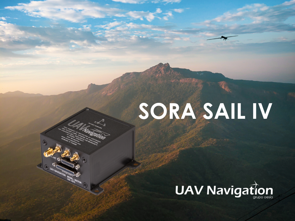
An independent study conducted by UAV Navigation has defined the operational envelope of the VECTOR-600 autopilot based on the Specific Operations Risk Assessment (SORA) methodology. The operational envelope defines the operational risk profile within which an aircraft can operate safely, taking into consideration all risk mitigations included within the system.
The SORA methodology evaluates the safety risks involved with the operation of an unmanned aerial system (UAS) of any class, size or type of operation. The concept of operation (ConOps) is normally used as the input for this analysis; the output takes the form of the Specific Assurance and Integrity Level (SAIL) for a particular operation, which indicates the level of robustness that must be demonstrated for the operational safety objectives.
In this case, instead of performing a conventional SORA analysis from the ConOps to the SAIL output, this study was performed the other way around because the objective of the study was to identify the operational envelope of the sytem.
EUROCAE ED-280, the guidelines for UAS safety and analysis for specific categories of low and medium levels of robustness, recommends to any operator a detailed definition of different mission and platform points: the ConOps, the entire UAS architecture including functions, systems, and implementation, identification and classification of failure conditions; verification that safety objectives are fulfilled and a complete probable failure analysis using FMEA-like techniques and Fault Tree Analysis (FTA).
UAV Navigation prepared an FMECA and FTA analysis performed by a third-party and independent company on the VECTOR-600 autopilot and its onboard sensor suite, the POLAR-300. The study concluded that within the operational envelope of the VECTOR-600, any failure – however remote the probability – is highly unlikely to result in a catastrophic outcome, such as the loss of the aircraft. The conclusions reached indicate that the system is perfectly suited for VLOS/BVLOS operations – including appropriate restrictions where applicable. The system has proved its robustness and suitability for safe operations over a wide range of missions usually performed by professional UAS.
The analysis is available on request to all clients interested. Contact UAV Navigation for more information.
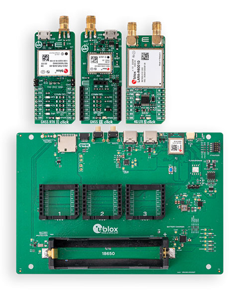
The development kits will bring together u-blox’s centimeter-level positioning and wireless communications expertise and services to support faster time-to-market for new products
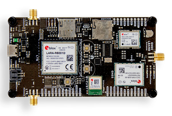
The XPLR-HPG-1 high-precision GNSS explorer kit. (Photo: u-blox)
U-blox has announced new explorer kits to make it quicker and easier for engineers to design and evaluate products requiring centimeter-level positioning capabilities.
Set to launch in early 2023, the ready-to-use XPLR-HPG-1 and XPLR-HPG-2 solutions will combine u-blox’s unique offering across the key technologies required to achieve highly precise positioning.
As well as an open microcontroller unit (MCU), the kits will include high-precision GNSS positioning with real-time kinematic (RTK), dead-reckoning, cellular, Wi-Fi and Bluetooth communications, along with the necessary antennas.
The kits are designed to integrate seamlessly with complementary u-blox services, such as PointPerfect GNSS augmentation service and the ubxlib software component.
The XPLR-HPG-2 High precision GNSS explorer kit. (Photo: u-blox)
The kits will assist engineers working in areas such as micro-mobility and low-speed robotics, helping them build, test and demonstrate early-stage proofs of concept more quickly, supporting faster overall time-to-market.
Both explorer kits will include the full gamut of u-blox technology and software required.
The modular XPLR-HPG-1 kit will be based around the wireless MCU in the u-blox NORA-W106 , with its Wi-Fi and Bluetooth LE capabilities, and will give engineers flexibility to adjust their solutions to their precise needs, using MIKROE Click boards featuring a variety of u-blox modules. The kit will include three Click boards, which respectively incorporate the ZED-F9R high-precision RTK GNSS module, the LARA-R6001D LTE Cat 1 module (global coverage and with built-in MQTT client), and the NEO-D9S L-band correction data receiver module. Engineers can purchase others based on their application’s needs. The kit’s source code will include example software for the Espressif IoT Development Framework (ESP-IDF), based on ubxlib software components.
The compact XPLR-HPG-2 will deliver an integrated solution, incorporating the ZED-F9R high-precision RTK GNSS, LARA-R6001D LTE Cat 1 (with global coverage and built-in MQTT client) and NEO-D9S L-band correction data receiver modules, as well as the NINA-W106 with its MCU, Bluetooth LE and Wi-Fi capabilities.
Groupe Gorgé has acquired navigation company iXblue. The move will bring together iXblue and Groupe Gorgé subsidiary ECA Group.
Groupe Gorgé is a European company specializing in high-tech industrial solutions for the robotics, maritime, navigation, aerospace and photonics markets. Together, iXblue and ECA Group will provide customers with components and complex systems to support critical missions in severe environments.
The two companies will have a global workforce of 1,500 people and will achieve an annual turnover of €250 million.
“In addition to our complementary activities, both our companies share a common DNA centered around innovation and entrepreneurship,” said Fabien Napolitano, president and CEO of iXblue. “This acquisition by Groupe Gorgé, which puts iXblue and ECA Group under the same roof, will enable us to create new synergies and strengthen our capacity to invest in research and development to offer solutions that are always at the cutting edge of technology.”
Dominique Giannoni, CEO of ECA Group, added, “With the combination of the technological expertise and global footprint of the two companies, we will provide unmatched value to our customers through our comprehensive portfolio of products and solutions. This operation consolidates our leadership in our markets and offers excellent growth prospects. The teams of our two companies have already started working closely together. We see great development opportunities that we are eager to share with our customers.”
A link to the live event will be sent to you two hours before the event. Your personalized event URL will be automatically generated by the ON24 system. To ensure receipt of the email, please whitelist this email address by adding it to your contacts: [email protected].
This presentation will begin at 1 p.m. EDT / 10 a.m. PDT on Thursday, August 11. A recording will also be sent to you the following day so you can watch it on-demand.
Audience members may arrive 15 minutes prior to live time. If you have any questions, please contact event producer Mackenzie Shoemaker at [email protected].
“Seen & Heard” is a monthly feature of GPS World magazine, traveling the world to capture interesting and unusual news stories involving the GNSS/PNT industry.
Xona’s first demonstration mission successfully completed testing at Experior Laboratories and prepares for launch on a Falcon 9 in May. (Photo: Xona)
TAKING GNSS PRIVATE
At press time, Xona Space Systems’ first in-space demonstrator satellite, named Huginn, was ready to launch on May 25 aboard Space X’s Transporter 5 mission. Xona said the launch is a significant step toward realizing its high-performance commercial navigation system, a constellation of small, powerful satellites in low Earth orbit that will meet the navigation and timing needs of intelligent systems.
U.S. cellular carrier AT&T is rolling out location-based routing to automatically transmit wireless 9-1-1 calls to the appropriate call centers, rather than relying on which cell tower handles the call. Cell towers can cover a 10-mile radius, and overlap with more than one call-center boundary. With location-based routing, a device can be located and routed within 50 meters of the device location. The “Locate Before Route” feature from Intrado enables AT&T to use device GNSS and hybrid information to route the call to the right call center.
Russian jets have been found using GPS receivers, while ground vehicles use paper maps, according to the UK Express. The GPS receivers were found taped to the dashboards of Russian SU-34s downed in Ukraine because of “the poor quality of their own systems,” UK Defense Secretary Ben Wallace said in a speech. With many reports of maintenance and aging issues for the Russian military, most likely the jets did not have quality GNSS receivers rather than the fault lying with GLONASS.
A Russian short-range ballistic missile, believed to be an unexploded Iskander missile, was found near Kramatorsk, Ukraine, in this photo released March 9 by Ukrainian authorities. (Photo: National Guard of Ukraine handout via Reuters)
UNEXPLODED BOMBS MAPPED
The HALO Trust is partnering with Esri to map unexploded ordnance in an immediate humanitarian response to the war in Ukraine. More than 10 million Ukrainians have been displaced by the war and many are forced to move across a landscape littered with unexploded rockets, bombs and landmines. In response, Esri has committed its cutting-edge geographic information system (GIS) software resources, expertise and staffing in support of HALO’s mission in Ukraine. HALO already is using GIS to map the heaviest conflict zones, and the partnership with HALO will support planning for future clearance operations.
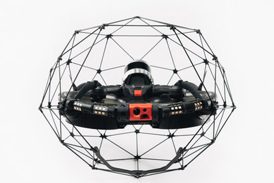
Flyability has unveiled the Elios 3, a collision-tolerant drone equipped with a lidar sensor for indoor 3D mapping. The drone is powered by a new SLAM engine called FlyAware that lets it create 3D models as it flies.
It also is accompanied by a new version of Flyability’s software for inspectors, Inspector 4.0.
The launch of the Elios 3 marks a new partnership with GeoSLAM. The Elios 3 comes with an Ouster OS0-32 lidar sensor, allowing inspectors to collect data for the creation of survey-grade 3D models using software from GeoSLAM.
The drone gives users real-time digital replicas of previously inaccessible areas with the inclusion of the lidar sensor and GeoSLAM’s Connect software. The drone is protected by a cage and has advanced collision-tolerance features that allow inspectors to fly it inside dangerous confined spaces such as boilers, pressure vessels and mines.
With its integration with Connect, the Elios 3 creates survey-grade point clouds. Fitted to the back of the drone, the lidar sensor maps the environment in real time using Flyability’s FlyAware SLAM algorithm.
Survey package option
Those that need highly accurate data can upgrade to the survey package, provided by GeoSLAM, providing access to the Connect software, as well as specialist Volumes and Draw modules. Powered by GeoSLAM’s established SLAM algorithm, Connect offers a simple and automated way to process point cloud data.
Using the survey package, data is processed to an accuracy of 8 mm, suitable for mapping hazardous environments such as mines and industrial applications including chimneys, production plants, warehouses, silos and tanks. Processed data can then be viewed in the easy-to-use 3D viewer and exported to industry-standard file types including LAZ, LAS, PLY and TXT for use in third-party software.
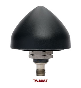
Tallysman Wireless has added the housed TW3885T dual-band (L1/L5) Accutenna technology timing antenna to its line of GNSS products.
The dual-band TW3885T antenna supports
GPS/QZSS L1/L5
Galileo E1/ E5a/b
BeiDou B1/B2/B2a
GLONASS G1/G3
Satellite-based augmentation systems (SBAS) in the region of operation: WAAS (North America), EGNOS (Europe), MSAS (Japan) or GAGAN (India).
Historically, dual-band antennas and receivers commonly supported GPS L1 and L2 and GLONASS G1 and G2. In recent years, GPS, GLONASS, Galileo, BeiDou and NavIC have added GNSS signals in the L5 frequency band (1164-1217 MHz). As a result, the new dual-band GNSS standard has become L1 and L5. Tallysman’s new TW3885T antenna has been tuned to provide optimal support for both the upper (L1/ G1/E1/B1/) and lower (L5/G3/E5/B2) GNSS bands.
The TW3885T is housed in a through-hole mount, weatherproof (IP69K) enclosure. For permanent installations, L-bracket (PN 23-0040-0) or pipe (23-0065-0) mounts are available. Tallysman provides an antenna installation guide that recommends a 100-125 mm ground plane and provides antenna installation and cable connector waterproofing best practices.
The radio frequency spectrum has become congested worldwide as many new LTE bands have been activated, and their signals or harmonic frequencies can affect GNSS antennas and receivers. In North America, the planned Ligado service, which will broadcast in the frequency range of 1526 to 1536 MHz, can affect GNSS signals. New LTE signals in Europe (band 32, 1452–1496 MHz) and Japan (bands 11 and 21, 1476–1511 MHz) have also affected GNSS signals. Tallyman’s new TW3885T mitigates the effects of these new signals.
Ola Rollén to be proposed as chairman of the board
Paolo Guglielmini, Hexagon
Hexagon AB has announced that Paolo Guglielmini will succeed Ola Rollén as president and CEO of Hexagon AB, effective Dec. 31.
Gun Nilsson has decided to step down as CEO for Hexagon’s principal shareholder MSAB on Oct. 1 and leave her position as chairman of Hexagon AB at the Annual General Meeting (AGM) 2023. MSAB, in consultation with Hexagon’s nomination committee, will propose Ola Rollén as new chairman of the board at the AGM 2023.
Guglielmini, currently Hexagon’s chief operating officer (COO) and president of Hexagon’s Manufacturing Intelligence (MI) division, has served in key roles since joining Hexagon in 2010, from strategy and business development to M&A and general management. He has been instrumental in expanding MI’s focus towards software-centric quality data solutions, and with his team driving the business towards all-time-high performance in 2021. Before joining Hexagon, Guglielmini held positions at CERN, the European Organization for Nuclear Research in Switzerland and Accenture. He holds a master of science in engineering and master of business administration from IMD.
”I’m happy that we have found an internal solution for my succession, which will bring long-term stability and continuity, but at the same time needed rejuvenation as we prepare this amazing company for the next big leap strategically,” Rollén said. “I have preoccupied myself with the well-being of Hexagon 24/7 for the last 22 years, and it’s a true privilege to be able to continue to follow the company’s successful development as chairman.”
“I’m honored by the opportunity to build upon the legacy that Ola and our team have created over the past two decades, and excited to lead Hexagon into the future,” Guglielmini said. “We are very well positioned to capitalize on the vast opportunities ahead, combining software, sensors and autonomous technologies to create sustainable value for our stakeholders.”
At the same time, the following organizational changes will be made:
Josh (Joshua) Weiss, currently COO of Hexagon Geosystems, will succeed Guglielmini as president for Hexagon Manufacturing Intelligence, effective July 1. Weiss has served in multiple leadership roles since joining Hexagon in 2015, from his most recent role to the president of Geosystems’ mining and heavy construction businesses. Weiss will report to Hexagon’s president and CEO and be a part of the Executive Management Team.
Michael Ritter, currently president of Hexagon Autonomy & Positioning, will assume a new senior role overseeing Hexagon’s Autonomy & Positioning, Mining and Agriculture divisions, effective immediately. In this role, Ritter will be responsible for leading the strategy of the businesses, to accelerate synergies and strengthening the solutions portfolio for Hexagon’s customers. Ritter will continue reporting to Hexagon’s president and CEO and be a part of the executive management team.
Maria Luthström, currently head of Sustainability and Investor Relations for Hexagon, will succeed Ritter as president of Hexagon Autonomy & Positioning, effective Oct. 1. Luthström joined Hexagon in 2015 and has been instrumental in expanding the company’s strategy and environmental, social and governance agenda, strengthening Hexagon’s culture and increasing shareholder value. Luthström will report to Michael Ritter.