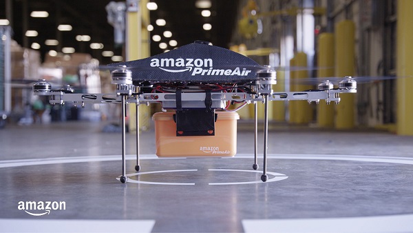
Amazon customers in Lockeford, California, will be among the first to receive Prime Air drone deliveries in the United States, later this year. According to an Amazon blog, the company has been working for almost a decade to make it a reality.
Customers in Lockeford will see Prime Air-eligible items on Amazon. They will place an order as usual and receive an estimated arrival time with a status tracker for their order. For these deliveries, the drone will fly to the designated delivery location, descend to the customer’s backyard, and hover at a safe height. It will then safely release the package and rise back up to altitude.
Customer feedback about Prime Air, with drones delivering packages in their backyards, will help Amazon create a service that will safely scale to meet the needs of customers everywhere, according to the company.
“Lockeford residents will soon have access to one of the world’s leading delivery innovations,” said California State Assemblyman Heath Flora, whose district includes Lockeford. “It’s exciting that Amazon will be listening to the feedback of the San Joaquin County community to inform the future development of this technology.”
“We are working with the Federal Aviation Administration (FAA) and local officials in Lockeford to obtain permission to conduct these deliveries and will continue with that collaboration into the future,” the blog said.
Amazon designed its drones’ sense-and-avoid system for two main scenarios: to be safe when in transit, and to be safe when approaching the ground. Its algorithms use a diverse suite of technologies for object detection, enabling it to identify a static object in its path, such as a chimney. It can also detect moving objects on the horizon, such as other aircraft, even when it’s hard for people to see them.
When obstacles are identified, the Amazon Prime drone will automatically change course to safely avoid them. As the drone descends to deliver a package into a customer’s backyard, it ensures that there’s a small area around the delivery location that is clear of people, animals or other obstacles.
Prime Air is one of three drone-delivery companies that has gone through the rigorous process to earn an FAA air carrier certificate, which will be required to operate drones using these advanced capabilities.
The company is engaged in trials with customers in mapping, surveying, robotics, construction, trucking, defense, aerospace and autonomous vehicle applications
Anello Photonics has made available an optical gyroscope and GNSS/inertial navigation system (INS) evaluation kit (EVK) for autonomous applications.
Powered by Anello’s optical gyroscope solution and sensor-fusion engine, the Anello EVK can maintain centimeter accuracy in conditions where far more expensive ground-truth positioning and localization systems degrade.
The Anello EVK is accurate in extended full GNSS-denied operation and is stable over wide temperature ranges and under extreme vibration.
“We are actively engaged with many customers to drive new technology adoption and explore how by providing high precision, highly scalable, optical gyro-based solutions we can accelerate and improve position accuracy for a wide range of autonomous use cases,” said Mario Paniccia, CEO of Anello Photonics. “We see a lot of interest around our unique and innovative integrated silicon photonics technology and our product roadmap, and are excited to be working with many industry leaders looking for cutting-edge innovation.”
The Anello EVK is designed to be easy to use while enabling seamless navigation and positioning in challenging GNSS-denied environments where accuracy is paramount.
“Anello’s optical gyroscope solution is perfect for our offerings due to its performance compared to other MEMS solutions currently available and used by the industry. The Anello solution provides ease of installation together with high accuracy and reliability,” said Sean Kish, CEO of Psionic. “Through our work with Anello, we’re seeing significant improvements in the performance of our SurePath product for long-range precision navigation in GNSS-denied environments.”
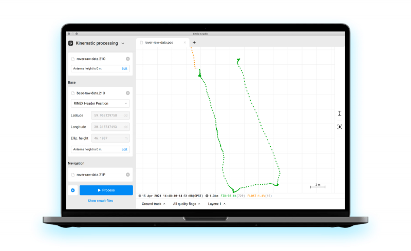
Emlid has released Emlid Studio, a new post-processed kinematic (PPK) application designed specifically for post-processing GNSS data. The app is free and available for Windows and Mac users.
Emlid Studio features a simple interface to make post-processing easy. The app allows users to convert raw GNSS logs into RINEX, post-process static and kinematic data, geotag images from drones (including DJI brand), and extract points from survey projects completed with Emlid’s ReachView 3 app.
With Emlid Studio, users can post-process data recorded with Emlid Reach receivers and other GNSS receivers or NTRIP services. Post-processing requires RINEX observation and navigation files. Raw data in UBX and RTCM3 format also can be used — Emlid Studio will automatically convert them into RINEX.
The post-processing workflow is straightforward. Users can receive precise positioning of a single point or track depending on the positioning mode. Users can simply add several RINEX files and enter the antenna height, click the Process button, and Emlid Studio will do the rest. Once the resulting position file is ready, the plot will show the result.
Another tool is available for the users of Reach receivers and the ReachView 3 app. The Stop & Go feature allows users to improve the coordinates of points collected in single or float modes.
Geotagging for drone mapping. Adding geotags to images’ EXIF data requires aerial photos and the POS file with the events. Emlid Studio also provides a chance to update data from the RTK drone in case of a float or single solution during a survey. A set of RINEX logs from a base and drone, an MRK file and images from the drone are dragged and dropped into specific file slots, providing result in seconds.
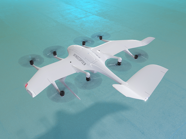
The U.S. Federal Aviation Administration (FAA) has issued the Special Class Airworthiness Criteria for the Wingcopter 198 U.S. unmanned aircraft. This approval marks a critical milestone in the certification process of Wingcopter’s flagship delivery drone in the United States.
Wingcopter is a German manufacturer of fixed-wing unmanned aircraft systems (UAS) and provider of drone delivery services, focused on optimizing medical supply chains, as well as last-mile logistics of packages, tools, spare parts, food, and groceries.
With the Airworthiness Criteria, the FAA defines technological requirements under title 14, Code of Federal Regulations (14 CFR), § 21.17(b) that must be met to have an aircraft type-certified for regular commercial operations in the United States.
The Wingcopter 198 is an electric vertical-takeoff-and-landing (eVTOL) drone engineered to meet stringent safety standards. In its development, Wingcopter was able to leverage the operational experience of more than five years with the company’s first delivery drone type in various geographical settings, from the Arctics to the Middle Eastern desert and from remote islands in the South Pacific to San Diego Bay in the United States.
Once type-certified, Wingcopter will be able to fly conventional routes through airspace and over populated areas, ultimately providing the basis for scaling commercial drone delivery operations across the United States that will help save and improve lives, the company said.
The certification is expected to have a positive impact on Wingcopter’s further certification efforts such as with the National Civil Aviation Agency (ANAC) in Brazil or the Japan Civil Aviation Bureau (JCAB).
Since applying for the Special Class Type Certificate in March 2020, Wingcopter has collaborated closely with the FAA. The issuance allows Wingcopter to focus its development efforts even more on what the FAA deems necessary for this particular aircraft to receive certification quickly and efficiently.
“We are proud to be among the first delivery drone companies worldwide to ever get their Airworthiness Criteria approved by the FAA,” said Tom Plümmer, co-founder and CEO of Wingcopter. “This is a very important milestone for us, not only in our Type Certification Process in the United States, but also for our international expansion efforts and for achieving our vision of building logistical highways in the sky. I would like to thank my team as well as the FAA for all the effort and great collaboration to reach this milestone.”
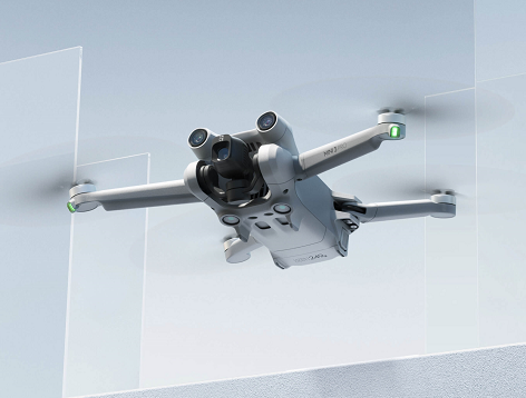
The DJI Mini 3 Pro is the high-end product of the DJI Mini series
DJI Mini 3 Pro. (Photo: DJI)
DJI has introduced the DJI Mini 3 Pro, its most powerful lightweight and portable camera drone. Weighing less than 249 grams — making it policy-friendly in many regions and countries — it delivers advanced features such as 4K/60 fps video, ActiveTrack, tri-directional obstacle sensing, and 90° gimbal rotation to shoot high-quality vertical imaging for social media. Its flight time extends past 30 minutes.
According to the regulations of many countries and regions, drones under 250 grams have been placed in the safest drone category. At under 249 grams, Mini 3 Pro’s weight, safety and performance is a new resource for content creators and new pilots.
Like its predecessors — Mavic Mini, Mini 2 and Mini SE — the Mini 3 can be folded for packing. Built-in features include enhanced flight performance, camera system, battery life and intelligent features previously available only in the Air and Mavic series.
New structural design. The arms and propellers have been adjusted for more aerodynamic flight, increasing flight time. Forward and backward dual-vision sensors broaden the sensing range for safer flight. A complete gimbal redesign unlocks more camera angles, enabling movements such as tilt-up shots and vertical shooting.
The Mini 3 Pro features tri-directional obstacle sensing, consisting of forward, backward and downward visual sensors. The forward and downward sensors have a wider field of view, providing seamless coverage for better route planning and environmental awareness. These sensors also enable Advanced Pilot Assistance System (APAS) 4.0, which automatically detects and finds a safer path around obstacles during flight.
In addition, these sensors enable the FocusTrack suite, which allows users to select a subject that the drone automatically keeps within the center of the frame during flight while automatically planning a safe flight route.
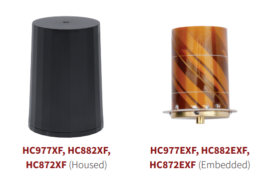
Tallysman Wireless has added eXtended Filtering (XF) to the housed and embedded lightweight HC977XF (triple-band + L-band), HC882XF (dual band + L-band) and HC872XF (dual-band (GPS and GLONASS) + L-band) precision helical GNSS antennas.
Tallysman has designed the XF feature to mitigate interference from all near-band signals and ensure that the antenna provides the purest GNSS signals.
The radio-frequency spectrum has become congested worldwide as many new LTE bands have been activated, and their signals or harmonic frequencies can affect GNSS antennas and receivers. In North America, the planned Ligado service, which will broadcast in the frequency range of 1526–1536 MHz, can affect GNSS antennas that receive space-based L-band correction service signals (1539–1559 MHz). New LTE signals in Europe (band 32, 1452–1496 MHz) and Japan (bands 11 and 21, 1476–1511 MHz) have also affected GNSS signals.
Tallysman’s housed helical antennas weigh ~42 g and are enclosed in a robust military-grade IP67 plastic enclosure. The antenna base has an integrated SMA connector, a waterproofing O-ring, and three screw holes to enable secure attachment. Tallysman’s embedded helical antennas weigh ~8 g and are easily mounted with an optional embedded helical mounting ring, which traps the outer edge of the antenna circuit board to the host circuit board or any flat surface.
An MCX connector is installed in the base of the antenna.
Tallysman helical antennas are suitable for a variety of applications, including lightweight unmanned autonomous vehicle navigation (land, sea and air), land survey devices, automotive positioning, timing and other precise-positioning applications.
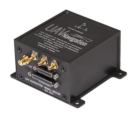
UAV Navigation has confirmed the safety and reliability of its Vector-600 autopilot for civil applications with an independent study. The study was performed as part of the European Union VaNeT project, and conducted by third-party company Anzen Engineering.
An autopilot system in an unmanned aerial vehicle (UAV) is the heart of the flight control system. For the Vector-600, the study included a reliability prediction report (RPR), failure mode effects and criticality analysis (FMECA) and fault tree analysis (FTA).
Reliability Prediction Report. The RPR analyzes probability of failure of every single sensor and component inside a system. It helps define component failure rates and, consequently, a prediction of the time that the VECTOR-600 is expected to operate free of failures under given operating conditions. According to this, the VECTOR-600 has shown a mean time between failures of more than 19,500 hours.
Failure Mode Effects and Criticality Analysis. A FMECA study identifies potential failures of system functions and assesses their effects, so that mitigation actions can be defined. It is a bottom-up analysis considering each single elementary failure mode and assessing its effects.
Fault Tree Analysis. Fault trees are a classic deductive analysis technique useful for both qualitative and quantitative analysis. For the Vector-600, a quantitative FTA provided probability estimates for major hazards, as well as identifying single-point failure modes and guiding further design for hazard reduction. According to the results, Vector-600 showed a probability of loss of mission per flight hour of 1,809E-05 under its operating conditions.
“The FMECA, RPR, and FTA analysis performed by the external and independent company Anzen have proven that our most advanced autopilot, Vector-600, is one of the most reliable GNC [guidance, navigation and control] systems for NATO Class I and II unmanned aircrafts available in the market and enables our clients to execute missions ensuring safety,” UAV Navigation stated in a press release.
The EU regulation framework defines three classes of operations: open, specific and certified. In specific and certified category operations, including most professional UAS flights, operators and aircraft manufacturers need to prove safe operation of their platforms. For this reason, the study of the reliability of the systems involved in the UAV becomes a must to demonstrate the system can operate free of failures under specific operational conditions.
Beluga is a new generation of small unmanned aerial systems (sUAS), the result of three years of design and development. The Beluga sUAS is designed to perform a wide variety of tasks including medical transportation, precision farming, search and rescue, and last-mile delivery.
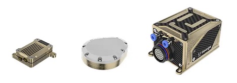
The system will include the uAvionix George G3, a CubePilot-based autopilot designed to DAL-C safety standards, and the truFYX EXT GPS which provides high-quality avionics at low size, weight and power consumption (SWaP) at a low cost. Beluga will soon include the ability to operate on skyLink C-band CNPC radios, fully integrated with George.
The George ecosystem includes a microLink radio, a truFYX GPS receiver and the George autopilot. (Photo: uAvionix)
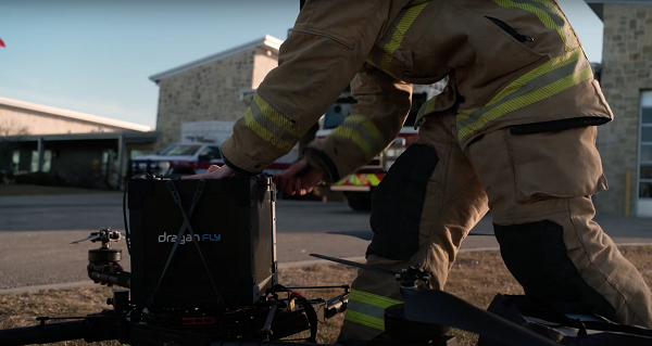
The first Draganfly humanitarian drone shipped to Revived Soldiers Ukraine (RSU) has arrived in Europe and will soon deliver insulin to hard-to-reach hospitals in Ukraine. Draganfly is a North American drone manufacturer.
RSU ordered 200 Draganfly medical response drones equipped with temperature-managed payload boxes that can transport up to 35 pounds of blood, pharmaceuticals, insulin/medicines, vaccines and wound-care kits. Because insulin is a temperature-sensitive product, quick and safe transportation of the hormone is a top priority.
About 2.3 million people in Ukraine live with diabetes. Many are Type 1 diabetics who need multiple daily injections of insulin to survive. For those living in high-conflict areas of the country, access to life-saving insulin is limited or non-existent.
NuGen Medical Devices donated the needle-free injection devices and 5,000 needle-free disposable syringes to be filled with insulin. Not only are life-saving medical supplies like insulin dwindling in Ukraine, but there is also an urgent need for many medicines across the country as hospitals have been under direct attack since Russia invaded on Feb. 24.
Draganfly medical relief drone. (Photo: Draganfly)
This month, we look at new applications that might interest even the most tech-savvy. From military Reaper unmanned vehicles being turned into civilian fire-fighters, through continuing drone flights on Mars, to e-scooters monitored by AI-system, the autonomous arena continues to grow.
Reaping Disaster-Response Benefits
The General Atomics Reaper unmanned aerial vehicle (UAV) is usually a weapon of war. Most of us picture them loaded with missiles to be fired on terrorist hideouts, with video of the impact appearing on the six-o’clock news. Soldiers in small control shacks guide these worldwide attacks, while politicians watch the outcomes remotely with their own direct TV coverage. This is how we tend to think of these destructive systems.
However, Reapers recently have been helping fight the huge fires devastating the California landscape — a more humanitarian, supportive role for a military asset.
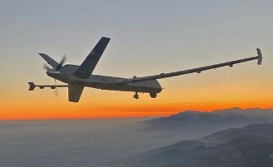
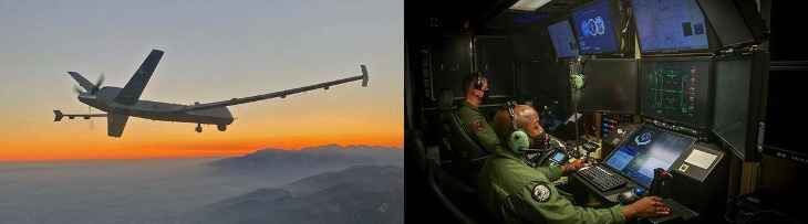
General Atomics Reaper UAV on patrol and remote pilots (Photos: California Air National Guard)
The California Air National Guard (ANG) has been assisting firefighters for many years by using helicopters and fixed-wing aircraft to determine the intensity of large California fires and to plot their boundaries.
In the past 10 years, with the availability of large reconnaissance UAVs and assistance from the Federal Aviation Administration to develop and approve operational procedures, an approach has been formulated to employ Reapers, with the potential to reduce costs and greatly improve response times.
Having large UAVs at altitude in civilian airspace requires an accompanying chase plane to ensure safe operation. With proven onboard detect-and-avoid capability and visibility through crew monitoring, the chase aircraft only monitors the Reaper’s climb to operational altitude. Using infrared and video from onboard cameras, data is downlinked and post-processed to create fire maps. Artificial intelligence (AI) automates this procedure to provide incident commanders with a near-real-time situational overview.
Besides mapping the fire, the incident commander can keep track of firefighters on the ground and gain a clearer picture of the fire’s intensity, rate of growth and direction. With a high altitude view of the landscape, Reaper pilots also help determine the best evacuation routes. Video downlinks provide real-time fire dynamics to commanders and even to firefighters on the ground who carry handheld devices.
When equipped with long-range fuel tanks, Reapers can remain on task for up to 18 hours. The pilot and systems operator in their remote mission-control shack can hand over control to a new crew for such a long mission. The new crew can even be in a different location when it assumes control.
The experience gained in California regarding flight approvals, operations and use of data is being shared with remote UAV crews and emergency-response controllers in other U.S. jurisdictions as well as other countries. The procedures can be used not only for firefighting, but also for earthquake, flooding and hurricane response.
Our Martian Adventure
NASA has extended the mission on Mars of its Ingenuity UAV, which arrived on the planet attached to the belly of the Perseverance rover. The original mission was to establish that controlled flight on the planet’s surface was possible.
Ingenuity has now spent more than one year on the surface of Mars and has 21 flights under its belt. The diminutive copter has taken on an extended role of scouting out potential routes for its SUV-sized mother ship.
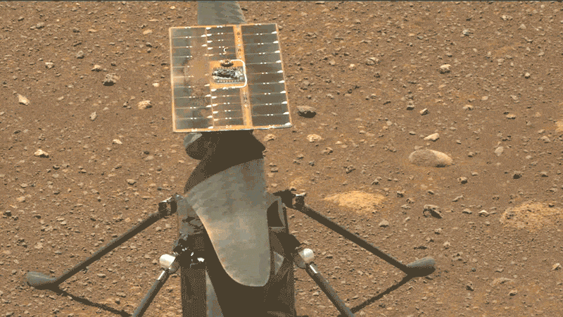
Integrity runs a “wiggle test” of its rotor blades prior to flight. (Photo: NASA/JPL-Caltech/ASU)
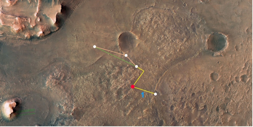
Ingenuity’s 21st flight is the first of at least three needed to transverse the Séítah region to reach its next base. From there, it will make flights to examine an old river delta. The whole relocation trip will cover about 1,150 feet as Integrity navigates around a large hill. While flying these investigative routes, the NASA team continues to gently push the drone’s capabilities to better understand improvements that can be applied to future Mars UAV designs.
Proposed route to reach river delta. (Image: NASA/JPL-Caltech/University of Arizona/USGS)
Once at the river delta, Ingenuity will encounter higher ground — up to 130 feet above the floor of the Jezero Crater, where it previously flew. The new area is expected to present significant obstacles: jagged cliffs, angled surfaces, rocky outcroppings and sand-filled traps. These obstacles could hamper the Perseverance rover or tip over the small drone on landing. But it’s also a place NASA thinks could harbor evidence of past life.
On arriving at the delta, Ingenuity’s first task will be to help decide which of two river channels Perseverance should take to climb to the delta. Data from the drone will also pick out science targets that Perseverance could investigate on the way. Once established in the delta region, NASA also hopes to fly Ingenuity to scout other features the rover might not be able to reach, but which might be accessible on future missions.
NASA has uploaded several upgrades to Ingenuity. They enabled higher, faster and longer flights and speed changes. The upgrades also have improved the drone’s perception of landing areas. Potential upgrades include adding terrain elevation maps and a hazard-avoidance capability for safer landing.
E-Scooters Adopt Pedestrian Defense
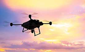
An outfit that rents e-scooters in more than 60 cities worldwide is adopting a “pedestrian defense” AI upgrade to prevent renters from abusing others around them and keep them riding within acceptable rules of operation.
LINK e-scooter. (Photo: Superpedestrian)
Previous efforts have only give riders visual and audio warnings that they should not enter a sidewalk. This new e-scooter active defense system slows the scooter to a stop and will not allow it to resume operation until it is moved outside the prohibited area.
Other unsafe behaviors — riding the wrong way up one-way streets, parking in the wrong place or aggressively swerving — also can be detected and actively deterred.
Sensors on the scooter provide data that relates location and activity to onboard stored city maps and geofenced areas. This enables application of enforcement commands within a second of them being detected.
The system provides cities and operators with visibility for the whole fleet of scooters. It shows what renters are doing within existing street safety restrictions, allowing both city and rental company officers to address perceived operational issues.
The U.S. Department of Transportation’s Federal Aviation Administration (FAA) has announced $4.4 million in drone research, education and training grants to seven universities.
Research will focus on three areas:
electromagnetic compatibility
detect-and-avoid classifications
cybersecurity oversight.
“This funding and our ongoing partnerships with these universities will allow the FAA to safely integrate the airspace that has a growing number of diverse aircraft users,” said FAA Acting Administrator Billy Nolen.
The research initiatives and grant awardees include:
Evaluate Unmanned Aircraft Systems (UAS) Electromagnetic Compatibility
This research will assess the risks, identify drone design vulnerabilities, identify material and procedural mitigations, and propose guidance for safer electromagnetic compatibility with emitted and static fields.
University of North Dakota, $325,042
University of Kansas, $325,000
Drexel University, $325,830
Investigate Detect-and-Avoid Track Classification and Filtering
This research will provide proposed metrics, guidance and test methods to assess the effects of false or misleading information on detect-and-avoid capabilities. The findings will support beyond-visual-line-of-sight operations.
The Ohio State University, $732,441
Embry-Riddle Aeronautical University, $371,000
Mississippi State University, $330,000
University of North Dakota, $80,000
Illustrate the Need for UAS Cybersecurity Oversight and Risk Management
This research will address UAS cybersecurity oversight and risk management as it pertains to the National Airspace System and other FAA systems.
The ASSURE Center of Excellence is one of six that the FAA has established to help advance technology and educate the next generation of aviation professionals. Research conducted through ASSURE is focused on helping the drone market safely grow and integrate into the nation’s airspace.
More than 800,000 recreational and commercial drones are in the active drone fleet, and that number is expected to grow.
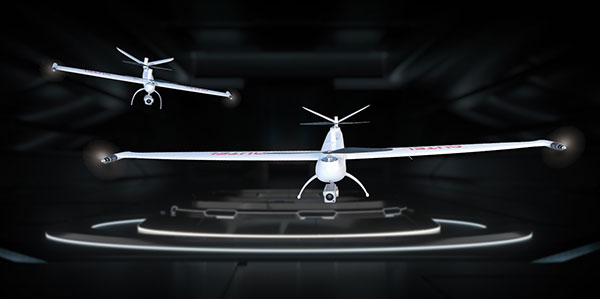
The Autel Robotics Dragonfish Lite and Pro UAVs are now available in the United States, joining the Dragonfish Standard and providing more options and choices for UAV pilots.
The rugged Dragonfish UAVs are capable of vertical takeoff and landing (VTOL) with both multi-rotor and winged flight, with an endurance of up to 180 minutes. They are suitable for professional applications such as energy, mining, defense and surveillance. Maximum winged flight speed is 30 m/s (108 km/h, 67 mph), and maximum video transmission range is 30 km (18.6 miles) with a base station.
The 1-tap take-off and landing capability point-and-click user interface, and other smart autonomous features make the Dragonish simple for anyone to operate, according to maker Autel Robotics. The aircraft can make a smart decision to either land or return to base in case of issues such as loss of GPS signal, loss of operator communications, or low battery power.
The Dragonfish tilt-rotor system will automatically transition to multi-rotor mode if adverse conditions cause fixed-winged flight to stall or become unsustainable. The Dragonfish battery, barometer, positioning system, compass and inertial measurement unit all have backup modules to ensure flight safety.
Dragonfish UAVs can carry a variety of payloads, including standard high-resolution cameras, 50x optical zoom cameras, 12-megapixel wide-angle cameras, 1280 x 1024 high-resolution infrared cameras, and laser rangefinders for various imaging, surveillance and mapping tasks.
All Dragonfish UAVs are built from tough carbon-fiber and fiber-glass composite, providing excellent IP43 wind and weather resistance. Despite the strong construction, these aircraft are designed to be easily disassembled for space-saving transport. They can be assembled in three minutes without tools. Disassembled, Dragonfish fits in the back of any car or SUV.
The larger Dragonfish Pro provides the longest flight time of the series, 180 minutes with payload, and has a 6,000-m (19,685-ft) flight ceiling, making it suitable for applications such as discreet long-endurance surveillance and wide-area mapping. The maximum payload capacity is 2.5 kg.
Compact and lightweight at 4.5 kg (including two batteries) with a 1,600-mm wingspan, the Dragonfish Lite can carry a 1-kg payload up to its service ceiling of 4,000 m, and has 75 minutes’ flight endurance.
Dragonfish Standard is already available. Dragonfish Lite and Dragonfish Pro will be available in the U.S. starting in April.
Firmware Release
The company also announced that pilots of Autel Robotics’ EVO Nano and EVO Lite series drones can download a firmware update that adds features including Dynamic Track 2.1 (person only), SuperDownload, 8-bit Log video, HDR video and other improvements. Some of these new firmware features are available now for selected models, and other features will become available for the EVO Lite, Lite+, Nano and Nano+ series in the near future.