The Business and Product Showcase for April 2013. Download the PDF.
Category: Uncategorized
-
Social Media and Big Data 101 for GIS professionals
Original Broadcast Date: Thursday, March 28, 2013
Webinar Topic/Abstract: Social Media and Big Data 101 for GIS professionalsExperts in this growing field will discuss the basics for those new to leveraging the technology in their GIS operation. Topics will include different kinds of social media, human geography, traits of each, other related public media, several case studies/examples.
Moderator:

Art Kalinski Art Kalinski
Editor, GeoIntelligence Insider NewsletterA career Naval Officer, Art established the Navy’s first Geographic Information System (GIS) in the mid-eighties. Completing a post graduate degree in GIS at the University of North Carolina, he joined the Atlanta Regional Commission (ARC) as the GIS Manager from 1993 to 2007. He pioneered the use of oblique imagery for public safety and participated in numerous disaster response actions including: GIS/imagery support of the National Guard during Katrina, UASI (Urban Area Security Initiative) a NIMS based field exercises in Atlanta and a fully manned, hardware equipped joint disaster response exercise in New York City. Art retired early from ARC to join Pictometry International to direct military projects using oblique imagery which led to him joining Soft Power Solutions, LLC. He has written articles for numerous geospatial publications including a monthly column for GeoSpatial Solutions/GPS World aimed at federal GIS users.
Speakers:Eric Gakstatter
Editor, Geospatial-Solutions.com, Geospatial Solutions Monthly NewsletterDr. Dan Tolley
CEO, Soft Power Solutions, LLCBob DowlingCo-founder, GeoCOPGen. Edwin “Skip” Vincent (USAF Ret.)Founder, Soft Power Solutions, LLCSteve LuttonDirector, Product Management, Geosemble Solutions -
GPS Innovation Alliance Welcomes New Affiliates
Five major national organizations representing a variety of industries are joining the GPS Innovation Alliance as affiliate members.
The alliance announced today that the American Trucking Association, the Association for Unmanned Vehicle Systems International (AUVSI), Boat U.S., the National Rural Electric Cooperative Association (NRECA) and the National Society of Professional Surveyors (NSPS) have signed on as alliance affiliates. Each shares in the alliance’s goal of protecting, promoting and further enhancing one of the world’s most important enabling technologies — technologies that improve the lives of people around the globe.
Headquartered in Washington, D.C., the GPS Innovation Alliance was launched in February. Its founding members are Garmin, John Deere, Topcon Positioning Systems and Trimble. Affiliate members previously announced include the Association of Equipment Manufacturers (AEM), General Aviation Manufacturers Association (GAMA) and the National Association of Manufacturers (NAM).
Following are comments from representatives of the newly announced affiliates.
Ted Scott, director of Engineering, American Trucking Associations: “GPS is important to the trucking industry. A robust and reliable GPS system enables drivers and fleet managers to select the best routes to guarantee pickup and delivery times, and to track shipments and fleets. It also helps save fuel by providing the most efficient routes. As GPS continues to modernize, we are pleased to support the GPS Innovation Alliance as an affiliate.”
Curtis W. Sumner, executive director, National Society of Professional Surveyors: “The productivity and precision benefits GPS provides professional surveyors are boundless. Virtually all surveyors use it for a growing number of applications that improve the national infrastructure every day. The modernization of GPS is critical to the future of surveying, which is why NSPS is pleased to offer the GPS Innovation Alliance its support moving forward.”
Michael Toscano, president and CEO, Association for Unmanned Vehicle Systems International: “All around the world, unmanned systems (air, ground and maritime) rely on accurate, dependable GPS signals. The lack of a reliable GPS signal poses a serious threat to our public safety and national defense, and this is why we support the GPS Innovation Alliance. We look forward to working with the Alliance in its effort to emphasize the importance of protecting our GPS.”
Margaret Bonds Podlich, president, Boat U.S.: “For anyone who has sailed their boat in unfamiliar cruising grounds, sought out new fishing holes, had to navigate in foul weather or simply stay the course in an unmarked channel, a reliable GPS system is a critical safety issue for everyone aboard. It is the only electronic navigation system available to boaters, and for our half a million BoatU.S. members, it must work every time, all of the time.”
Laura Marshall Schepis, senior director, Legislative Affairs, National Rural Electric Cooperative Association: “NRECA is pleased to be a part of the GPS Innovation Alliance. Electric cooperatives are increasingly relying on GPS technology as they upgrade and modernize the nation’s electric system. The GPS Innovation Alliance can support modernization by ensuring utilities have access to the spectrum they need for these new applications.”
The GPS Innovation Alliance recognizes the ever increasing importance of GPS and other GNSS technologies to the global economy and infrastructure and is firmly committed to furthering GPS innovation, creativity and entrepreneurship. The GPS Innovation Alliance seeks to protect, promote and enhance the use of GPS.
-
Apple’s $100M Settlement over Kids’ In-App Purchases Sparks Controversy
Developers and consumers are divided over where responsibility lies around in-app purchases for mobile games by children. Apple’s settlement of a class-action lawsuit over the use of in-app purchases (IAPs) by children for $100 million sparked considerable disagreement across social media.
According to the terms put forth by Apple, anyone whose children purchased currency, medals, weapons or other virtual goods in an iOS app will be given a $5 iTunes store credit. The parents need to prove they didn’t give their children their iTunes account password, and that the IAPs were made by a minor. If consumers can prove their child spent more than $30, they will be entitled to a full refund rather than an iTunes credit, Apple said.
While some consumers applauded Apple’s decision, there seems to be concern among some developers that the company gave into undue pressure from those involved in the class action suit.
-
Navigation Test Supplier IFEN Establishes U.S. Company
IFEN GmbH, based outside of Munich, Germany, has established IFEN Inc. in the United States. The new U.S. company will address the needs of the American market for GNSS test equipment, IFEN said.
“IFEN Inc., located in Corona, California, will greatly facilitate order placement, delivery and support for U.S. customers,” said Günter Heinrichs, head of Customer Applications and Business Development, of IFEN GmbH. “We look forward to addressing the needs of this market.”
IFEN has appointed of Mark Wilson vice president of sales at IFEN Inc. Wilson has more than 20 years of experience in the GNSS market. “I am very excited to join the IFEN team. They have extensive experience in all aspects of GNSS and I am looking forward to offering this expertise and the excellent IFEN products to the American Market,” Wilson said. “Our exceptional products offer unrivaled flexibility and capability, at realistic prices providing huge advantages to our customers.”
IFEN has more than 15 years of experience in GNSS and offers a range of GNSS test equipment, including simulators capable of simulating all GNSS constellations and frequencies and a multi-GNSS software receiver.
-
Precision Timekeeping with Chip-Scale Atomic Clocks
Broadcast Date: Thursday, March 7, 2013
Speaker: Steve Fossi, Director of New Business Development, Symmetricom
Panelist: Ravi Pragasam, Marketing Manager, Embedded Solutions, SymmetricomWebinar Topic/Abstract: Precision timekeeping with all the benefits of Size, Weight and Power (SWaP) – Quantum(tm) SA.45c Chip Scale Atomic Clock (CSAC)
Atomic clocks have enabled a world where ultra-precise timekeeping is now mandatory for communications, navigation, signal processing and many other applications critical to a modern functioning society. While smaller, lighter and more energy efficient solutions have been introduced to serve the above markets, the atomic clocks used in these systems have not kept in pace and continue to use more power and retain their large form factors. Symmetricom, the industry leader in precise time solutions, has utilized leading edge technology and multiple innovations in various disciplines such as semiconductor laser technology, silicon processing, vacuum-packaging and firmware algorithms to deliver the Quantum SA.45c CSAC (Chip Scale Atomic Clock). The CSAC is small in size, has low weight and consumes very little power. Such an atomic clock with excellent precision in time keeping is ideal for applications that have a constrained power budget and demand a very low-power clock.
Attend this webinar and learn how the CSAC can address your requirements for a precise clock without consuming excessive power or taking up too much space in your application.
-
Averna Wins 2013 DesignVision Award
Averna, developer of test solutions and services for communications and electronics device makers worldwide, today announced that its Proligent Analytics has been honored with a DesignVision award for most innovative verification tool of the year.
The awards ceremony took place on January 29, in Santa Clara, California, during the 2013 DesignCon show. The DesignVision awards, handed out annually, honor the most innovative design tools in the electronics industry. Winners were selected based on three criteria: how well the product met the market’s vision and offered unique insight into customer needs; the originality of the solution and if it offered a new approach to meeting market needs; and the quality of the implementation and how well it fits the market requirements.
Proligent Analytics gives OEMs a tool to centrally monitor and control manufacturing test operations across their supply chain. Version 6.0, released in August 2012, includes enhancements that provide easier navigation of test and quality data, broader reporting, and alarm capabilities for improved and quicker root-cause analysis.
“We had quite a challenging time choosing these winners among all of the innovative products we judged,” said Patrick Mannion, Content Director and Brand Director EDN, Test & Measurement World & Planet Analog. “Ultimately, our 2013 winners represent the best of the best in each of their respective industries.”
“With contract manufacturers and service centers dispersed across the globe, test data is often scattered across multiple sites and can require months to gather and transform it into useful information. Such delays can lead to significant quality-related issues. Proligent Analytics was designed specifically to offer product designers better access to their test data and give them important visibility regarding product development,” said Eric Lamontagne, Team Leader Proligent Analytics for Averna. “We are honored that Proligent Analytics was recognized with this prestigious award. It is a validation of our efforts.”
Be sure to check out Averna’s White Paper, “Expanding GNSS Testing,” offered by GPS World.
-
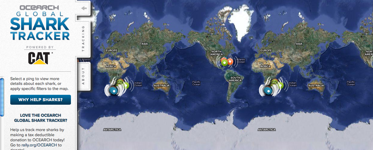
Shark in the Water! Find out Where
Did you just watch Jaws? Are you worried your trip to the beach might be interrupted by an unwelcome guest? Now you can go online and see if any great white sharks are visiting nearby waters (the tagged sharks, at least.)
The Ocearch Global Shark Tracker is a global project to tag and track the navigational patterns of great white sharks in the world’s oceans. The team is currently tracking nearly 40 sharks. The team of scientists have 15 minutes to pull a shark from the water, tag it, and release it, a process which was highlighted in an ABC Nightline feature.
Ocearch’s founder is Chris Fischer, former star of the History Channel reality TV show “Shark Wranglers.” Ocearch is “seeking to attain groundbreaking data on the biology and health of sharks, in conjunction with basic research on shark life history and migration,” according to its website.
On the Shark Tracker, sharks that have been tagged appear as bright colored dots. Orange means a ping is less than 72 hours old, green means a ping is less than 30 days old and blue means a ping is more than 30 days old.
-
Fujitsu Shows off High-Tech Walking Cane with GPS
Fujitsu has revealed a walking cane with built-in GPS. Fujitsu displayed the cane at Mobile World Congress 2013 in Barcelona, Spain, reports engadget. No launch date has been set for the device.
Fujitsu’s GPS cane allows users to set a route and get directions through an LED display in the handle, and follow directions along with a large arrow. If the walker turns the wrong way, the handle vibrates to alert him or her. The cane also allows friends and family to track a user’s location, and send an email alert if the user has fallen down.
The cane include medical monitoring features, with a sensor that monitors the heart rate and skin temperature of the user. This information can be viewed online in real time, giving caregivers peace of mind while allowing the cane user greater independence.
Read more about the device, and engadget’s hands-on demo, at the blog’s website.
-
Researchers See Ionospheric Signature of North Korean Nuclear Test
The explosion of an underground nuclear device by North Korea this week disturbed the Earth’s ionosphere. The blast generated infrasonic waves that propagated all the way to the upper atmosphere causing small variations in the density of electrons there.
By analyzing the signals from GPS satellites collected at ground-based monitoring stations in South Korea and Japan, scientists at the California Institute of Technology’s Jet Propulsion Laboratory, Purdue University, and the Korea Advanced Institute of Science and Technology independently confirmed the ionospheric disturbance generated by the North Korean test.
The researchers used the same GPS signals that are used by surveyors for precise positioning. These signals are slightly perturbed as they transit the ionosphere, and by processing the collected data with sophisticated software, the researchers were able to detect the small effect that the explosion-induced atmospheric waves had on the distribution of the ionosphere’s electrons.
The same technique is being used by the researchers and others to study the ionospheric effects from natural hazards such as tsunamis, earthquakes, and volcanic eruptions.
A team from The Ohio State University and Miami University are engaged in a similar project.
-
CryoSat-2 Mission Reveals Major Arctic Sea-Ice Loss
Arctic sea ice volume has declined by 36 percent in the autumn and 9 percent in the winter between 2003 and 2012, an international team of scientists has discovered.
Researchers used new data from the European Space Agency’s CryoSat-2 satellite spanning 2010 to 2012, and data from NASA’s ICESat satellite from 2003 to 2008 to estimate the volume of sea ice in the Arctic.
They found that from 2003 to 2008, autumn volumes of ice averaged 11,900 cubic kilometers (2,855 cubic miles) But from 2010 to 2012, the average volume had dropped to 7,600 cu. km. (1,823 cu. mi.) a decline of 4,300 cu. km (1,032 cu. mi.) The average ice volume in the winter from 2003 to 2008 was 16,300 cu. km. (3,911 cu. mi.), dropping to 14,800 cu. km (3,551 cu. mi.) between 2010 and 2012 — a difference of 1,500 cu. km. (360 cu. mi.).

A Polar-5 aircraft flying over an Arctic site uses its instruments to validate sea-ice thickness measurements made from space by the Cryosat-2 satellite. (Credit: R. Willatt) ‘The data reveals that thick sea ice has disappeared from a region to the north of Greenland, the Canadian Archipelago, and to the northeast of Svalbard,” said Katharine Giles, a research fellow at the Centre for Polar Observation and Modelling at University College London (UCL) and a member of the scientific team.
Giles and her colleagues report their findings in a paper that has been accepted for publication in Geophysical Research Letters, a journal of the American Geophysical Union. AGU has posted the manuscript online as an accepted article.
The findings confirm the continuing decline in Arctic sea-ice volume simulated by the Pan-Arctic Ice-Ocean Modelling and Assimilation System (PIOMAS), which estimates the volume of Arctic sea ice and had been checked using earlier submarine, mooring, and satellite observations until 2008.
Other satellites have already shown drops in the area covered by Arctic sea ice as the climate has warmed. Indeed, sea-ice extent reached a record minimum in September 2012. But CryoSat-2, launched in April 2010, differs in that it lets scientists estimate the volume of sea ice — a much more accurate indicator of the changes taking place in the Arctic.
“While two years of CryoSat-2 data aren’t indicative of a long-term change, the lower ice thickness and volume in February and March 2012, compared with same period in 2011, may have contributed to the record minimum ice extent during the 2012 autumn,” said Professor Christian Haas of York University, Canada Research Chair for Arctic Sea Ice Geophysics, co-author of the study and coordinator of the international CryoSat sea ice validation activities.
CryoSat-2 measures ice volume using a high-resolution synthetic aperture radar altimeter, which fires pulses of microwave energy down towards the ice. The energy bounces off both the top of sections of ice and the water in the cracks in between. The difference in height between these two surfaces let scientists calculate the volume of the ice cover.
The team confirmed CryoSat-2 estimates of ice volume using measurements from three independent sources — aircraft, moorings, and NASA’s Operation IceBridge.
The research was funded by the Natural Environment Research Council, the European Space Agency, the German Aerospace Center, Alberta Ingenuity, NASA, the Office of Naval Research and the National Science
Foundation. -
GPS Market Report Forecasts Growth, but Not Comprehensive
TechNavio’s analysts forecast the GPS market to grow at a CAGR of 25.8 percent over the period 2011-2015, stated in a press release for a recent report, “The Global Positioning System Market 2011-2015.” The company declined to provide any details of substance to back this claim.
The company’s press release states that “Key vendors dominating this market space include Garmin Ltd., MiTAC International Corp. and TomTom International BV.” This leaves out several key manufacturers of low-cost, low-precision GPS chips and devices, including the large suppliers into the smartphone market. It evidently makes no attempt to include the high-precision segment. Thus it is unlikely that the report presents a complete picture of the market, and its accuracy is also open to conjecture.
The press release goes on to say that “Other vendors mentioned in this report include Trimble Navigation Ltd. and DeLorme,” but does not say in what context or to what depth these two, among many others that could have been included, are “mentioned.”
