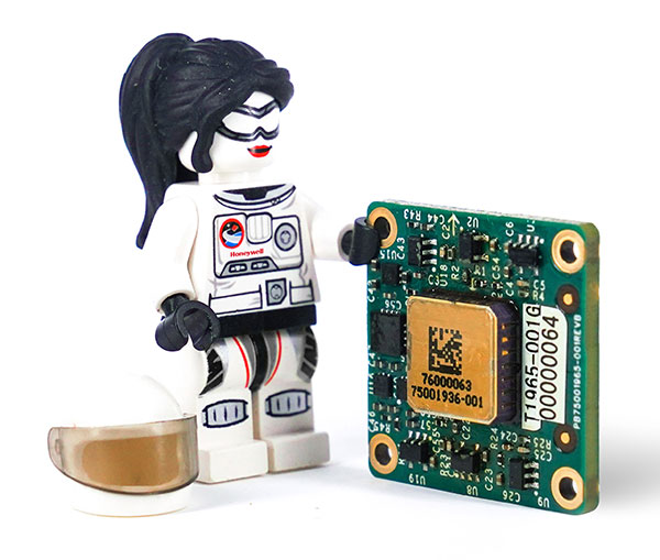
A LEGO Minifigure beside the MV60 shows its small size. (Photo: Honeywell)
Honeywell has unveiled a new accelerometer that delivers high performance and reliability in a small, rugged and low-cost package. The MV60 micro-electromechanical system (MEMS) accelerometer is designed for aerospace and defense, but also has potential uses in industrial and marine applications that require high-precision, navigation-grade accelerometers that are small, lightweight and require little power to operate.
The MV60 measures the acceleration experienced by an object during movement. These types of high-accuracy sensors are mainly used in inertial measurement units and navigation systems deployed on land, air and sea vehicles to measure velocity.
Additionally, inertial systems provide:
key orientation information for drilling operations
precision pointing and altitude determination for vehicles
platform stabilization
target location and surveying.
“The MV60 accelerometer is a technological breakthrough that leverages 50 years of Honeywell inertial sensor and MEMS experience to offer excellent reliability, ruggedness and performance,” said Matt Picchetti, vice president, Navigation and Sensors, Honeywell Aerospace. “Our customers in a wide range of markets will benefit from an accelerometer that is smaller, lighter and requires less power over similar offerings, and they won’t have to sacrifice performance.”
The highly reliable Honeywell MV60 accelerometer features a compact footprint of 1.2 square inches and has shock survivability of up to 5,000 g (g-force). It also offers bandwidth of greater than 300 Hz (hertz) — important for environmentally demanding missions.
The MV60 delivers accuracy and performance that previously had only been available in more expensive solutions. Now, customers have a more affordable, rugged, and small-scale offering suitable for the most demanding navigation applications.
Accelerometers are critical elements of navigation systems, and Honeywell provides a portfolio of precision accelerometers that deliver reliable performance at affordable prices to meet customer needs.
The open access portal for NAVIGATION: Journal of the Institute of Navigation is now live at live at navi.ion.org.
“ION has partnered with HighWire Press to host its new open access portal for NAVIGATION giving readers a sophisticated platform that offers superior search tools, advanced research capabilities, new citation tools and article alerts,” said Lisa Beaty, ION’s executive director.
“NAVIGATION’s open access portal will allow for the rapid dissemination of cutting-edge, high-impact research across the breadth of the field of positioning, navigation and timing (PNT) as well as all related areas intersecting with PNT,” Beaty added.
PNT researchers, academicians and industry members can now access free and open research through NAVIGATION’s new portal. The portal makes it easier to:
download NAVIGATION open access papers for reading, sharing and citating
A link to the live event will be sent to you two hours before the event. Your personalized event URL will be automatically generated by the ON24 system. To ensure receipt of the email, please whitelist this email address by adding it to your contacts: [email protected].
This presentation will begin at 1 p.m. EDT / 10 a.m. PDT on Thursday, April 28. A recording will also be sent to you the following day so you can watch it on-demand.
Audience members may arrive 15 minutes prior to live time. If you have any questions, please contact event producer Aurora Harris at [email protected].
Smith Myers showcased ARTEMIS, a mobile phone detection and location system designed specifically for airborne search and rescue (SAR) and disaster relief, at a helicopter trade show in Dallas.
The company, founded 35 years ago in the United Kingdom, also designed and developed software-defined radio and cellular protocol stacks designed specifically for the SAR role. According to the company, ARTEMIS turns any mobile phone into a rescue beacon, only requiring two antennas to generate a latitude/longitude fix at up to 19 nautical miles (35 km), offering an alternative to traditional airborne sensors.
ARTEMIS’s features include:
texting and calls in no service areas
possible automatic cueing of electro-optical/infra-red (EO/IR)
deployment as a stand-alone with embedded mapping or integration with mission system providers
making missions in low light / instrument meteorological conditions (IMC) safer and more successful and
availability in several SWaP configurations for manned/unmanned platforms.
Smith Myers announced in February that ARTEMIS has been integrated into the new Robotics Centre Echo SAR payload for small unmanned aerial systems (UAS) built by Teledyne FLIR Defense.
ARTEMIS airborne capabilities are available for use on manned rotary and fixed-wing platforms and drones with large and small payloads. It has already been in service with the AW101 Norwegian all-weather SAR helicopter and can be deployed across payload categories down to a small quad-rotor UAV.
Jack Dangermond, co-founder and president of geographic information system (GIS) giant Esri, told his customers on March 10 that he is “shocked and distressed by the grim circumstances in Ukraine.” Consequently, he announced, Esri and its distributor Esri CIS have stopped all their sales to Russia and Belarus. The company is also supporting several organizations across Europe “in their humanitarian and military efforts in support of the Ukrainian government and its people.”
“The invasion of Ukraine is a devastating chapter in our history,” Dangermond continued. “We have heard from so many members of our GIS community who, like us, stand with the Ukrainian people. Make no mistake, this is a daunting moment that will demand strength, compassion, and resolve from all of us.”
Hexagon AB, a provider of digital reality solutions combining sensor, software and autonomous technologies, has acquired ETQ, a provider of SaaS-based quality management system (QMS), environment, health and safety (EHS) and compliance management software.
Customers have long relied on ETQ’s QMS solution, ETQ Reliance, which provides the data backbone for automating the collection and delivery of manufacturing quality control data, non-conformance reports, customer feedback and more, providing an enterprise view of quality management across a product’s lifecycle. Its portfolio of applications comes with out-of-the-box functionality and no-code configurability, enabling customers to tailor the solution to their needs and optimize business processes to achieve their quality, safety and environmental goals.
ETQ’s data management capabilities, driven by machine learning and artificial intelligence, make quality data fully actionable and available further upstream. In addition to reducing defects, scrap, rework, and recalls, it enables an autonomous feedback loop, digital information trail and virtuous cycle of continuous improvement.
Founded in 1992 and with a staff of 185, ETQ is headquartered in Massachusetts with additional offices in Arizona and Dublin, Ireland. It operates in industries including the life sciences, healthcare, heavy manufacturing, electronics, food and beverage, heavy process, and automotive. ETQ will operate as part of Hexagon’s Manufacturing Intelligence division. Completion of the transaction is subject to regulatory approvals and other customary conditions, which are expected to be fully completed by early in the second quarter 2022.
Last month we attempted to provide an overview of the issue concerning Federal Communication Commission’s (FCC) licensing of C-Band radio spectrum, the subsequent fielding of wireless service for 5G phones and the Federal Aviation Administration’s (FAA) announcements that potential interference could be possible between 5G signals and C-Band radio altimeters on commercial aircraft.
Not a big deal most people might say, as faster and improved phone and data messaging on their smartphones begins to kick in, while wireless companies continue roll-out of the new 5G service. But wait – don’t some of these people fly out on vacation and then back and land at local airports, and many of us fly around the US to visit friends and family, or each week shuttle around the country doing fly-in/fly-out business?
Well FAA and the wireless companies have largely collaborated during 5G service roll-out, and the FAA has been rapidly clearing a good number of rad-alt (radio altimeter) equipped aircraft to continue regular operations into most airports. And it seems that wireless companies have limited 5G fielding around some US airports by reducing transmitted power and/or limiting the density of 5G towers.
But where are we now? Seems some aircraft equipped with some types of rad-alt can fly into some airports – the FAA published a list for aircraft operators and pilots identifying who can do what and where. They also published several ADs (Airworthiness Directives) which limit several aircraft types from flying into certain airports, ‘prohibiting certain operations, which require radioaltimeter data to land in low visibility conditions, when in the presence of 5G C-Band interference’. For any aircraft passengers flying into LaGuardia on a foggy day or Boston when ice-fog hangs in the air – low visibility landing capability on modern aircraft is a blessing and a wonder which allows us to travel, even in bad conditions.
Seems that, typically – ‘many systems on (XY Type) aircraft rely on the radio altimeter, including autothrottle, ground proximity warning, thrust reversers and Traffic Collision Avoidance System,’ says one recent FAA AD.
That’s a whole bunch of critical systems which help an aircraft land. Many experts over many years have spent whole careers supporting the process of developing safety systems for auto-land and those which assist in the manual landing of aircraft. And the FAA and other agencies around the world have made every manufacturer prove and prove again that these systems work and work extremely, reliably, well.
Not that I’m against 5G – I have a 5G phone and I’m eagerly waiting for 5G applications to use on my phone. – the service seems to be very fast when in an area where 5G has been fielded. There are some wireless companies who have decided that 5G can by-pass cable in the distribution of TV channels – this is good stuff! Let’s have more of it!
But why on earth do we need to even partially compromise any aircraft systems which safely land aircraft?
Japan and France have been cited as counties in which 5G has not had any impact on the very same aircraft and their operations with which the FAA has found problems. Well, except those countries seem to have taken steps in the fielding of 5G which have protected their aircraft operations. The FAA quotes several mitigations used in those countries:
• Lower power levels
• Antennas adjusted to reduce potential interference to flights
• Different placement of antennas relative to airfields
• Frequencies with a different proximity to frequencies used by aviation equipment
Let’s hope that FAA’s intense efforts to test and clear rad-alts under the simulated intensity of C-Band interference around airports will continue unabated and that soon we aviation nuts will begin to breath more easily.
And let’s hope that the wireless companies cooperation, acceptance and mitigation steps – for which the whole aviation community is extremely grateful – that these very positive steps will directly lead to the whole issue fading away over time as old news.
And then a few words about ‘the war‘ which Russia just began against its neighbor and previous member of the USSR – Ukraine has been independent from Russia since the USSR ‘dissolved’ (Wikipedia) in 1991.
Ukrainians are pretty resilient and the news today is that a woman in Kyiv brought down a Russian drone by throwing a jar of pickles at it from her (high-rise?) balcony. This story of course isn’t verified, but it’s a small lightness in a very grim situation.
General Atomics armed MQ-9 Reaper (Militaryanalizer.com)
And its reported that Poland just placed an urgent operational requirement for armed MQ-9 Reapers in order to better protect its Eastern border with Ukraine. The border is around 530 miles long and is the main crossing point for the thousands of refugees fleeing the Russian onslaught. Poland has apparently already taken in almost a million people seeking safety.
Drones are now part of modern warfare and both East and West have pretty sophisticated, capable, weapon-carrying unmanned aircraft. But they also usually carry highly accurate satellite navigation and laser-guided weapons which may minimize unintended casualties – unless casualties are exactly what the Russians are after.
Really sad state of affairs which we all may still follow in detail through news reports, even though Russia has completely shut down social media and virtually outlawed on-the-ground news reporting.
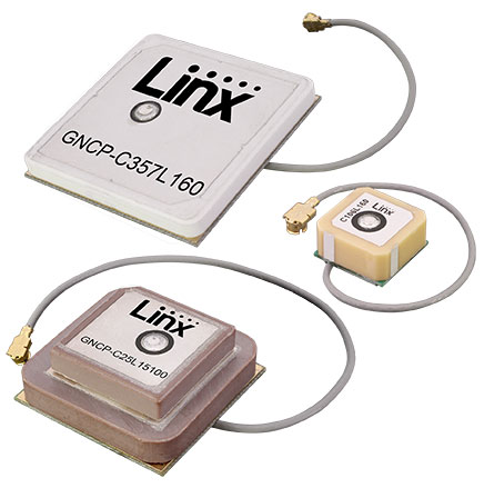
Linx Technologies has introduced seven GNSS active ceramic-patch antennas. These antennas support global GNSS applications including GPS, Galileo, GLONASS, Beidou, NavIC and QZSS systems in the L1/E1/B1, L2/E5/B2B, and L5/E5/B2A bands.
Each antenna integrates a high-gain low-noise amplifier (LNA) and right-hand circular polarization (RHCP) to provide a high-performance solution for GNSS signal reception. Each active GNSS antenna has either a 60-mm or 100-mm coaxial cable terminated in a MHF1/U.FL-type plug (female socket) connector.
“Linx Technologies continues to expand our popular GNSS antenna portfolio by adding more L1 options to serve our customers’ varied size and performance requirements,” said Linx CEO, Tolga Latif. “Our new active ceramic patch GNSS antennas also meet the need for multi-band L1/L2, L1/L5, and L1/L2/L5 GNSS offerings.”
The new active GNSS antennas are available now via Linx Technologies’ distributor and manufacturer representative networks. For larger quotes, contact Linx Technologies at [email protected].
The PureL5 Customer Evaluation System is being tested by California and Chinese companies
OneNav has announced the commercial availability of its pureL5 GNSS digital IP core.
The pureL5 digital IP core’s architecture enables it to directly acquire and track L5 signals from GPS, Galileo, BeiDou, QZSS and GLONASS without any L1 aiding. This eliminates the entire L1 RF chain, saves space on the printed circuit board, and simplifies the RF front-end and antenna subsystem in smartphones, wearables and trackers.
The pureL5 digital IP core’s massively parallel array processor searches the entire 1-millisecond L5 code space in parallel, delivering 1 second time to first fix (TTFF). The pureL5 digital IP core is 0.28mm2 in the 3-nm semiconductor process and consumes 4.7 mW of power in 1-Hz tracking mode.
OneNav has delivered the pureL5 digital IP core register-transfer level (RTL) to its first system-on-chip (SOC) customer. IP core RTL verification and physical implementation are complete, and oneNav’s SOC licensee will tape out in the first quarter of this year. The pureL5 digital IP core RTL is available for customer licensing and shipment now.
Customer Evaluation System. OneNav’s pureL5 Customer Evaluation System is being tested by companies in California and China. The system is available for smartphone and wearable OEMs and SOC providers who want to evaluate oneNav’s pureL5 in the field and the lab.
PureL5 GNSS Features
Smaller footprint than L1+L5 hybrids, simplifying implementation in highly space-constrained devices such as 5G smartphones and wearables
Lowers bills of material (BOM) cost and simplifies the RF front-end and antenna subsystem by eliminating the entire L1 RF chain
No L1 aiding required: directly acquires L5/E5/B2 with 1-second TTFF
Less software complexity, simplifies RF coexistence engineering
Better interference resiliency
Scalable IP signal processing core is semiconductor process-node independent
As a new member of the DIFI Consortium, WORK Microwave will help advance the digitization of satellite communication ground technologies
WORK Microwave, a leading European manufacturer of advanced satellite communications equipment, today announced that it has joined the Digital Intermediate Frequency Interoperability (DIFI) Consortium, an independent space-industry group that formed to advance interoperability in satellite and ground-system networks.
As a new member of DIFI Consortium, WORK Microwave joins a growing roster of leading organizations in the space industry committed to bringing innovation to the digital transformation of space, satellite and related technologies.
“With the new space boom and LEO constellations emerging, digitization of the ground segment plays a key role in scalability and sustainability,” said Jörg Rockstroh, director of business development and digital products at WORK Microwave. “Being a prime supplier of satellite communications equipment, WORK Microwave actively supports standardization and other industry-wide efforts to simplify the ecosystem. Joining the DIFI Consortium is an excellent opportunity to help shape the future digitization of the satellite communication ground segment.”
WORK Microwave is an early adopter of new technologies, including digital signal processing, modem infrastructures, optical communication and Q-/V-band equipment. As a long-term contributor to industry standardization, the company has a history of helping advance satellite communication ground technology.
“The DIFI Consortium’s goal is to provide a simple, open, interoperable digital IF/RF standard that replaces the natural interoperability of analog IF signals and helps prevent vendor lock-in,” said Stuart Daughtridge, chair of DIFI Consortium. “We welcome WORK Microwave to the group and look forward to seeing how they will contribute to moving interoperability forward across space networks.”
ST Engineering, Sumitomo Corp. and Skyports have formed a consortium to provide unmanned aircraft system (UAS) services for heavy-lift shore-to-ship parcel delivery in Singapore, home to one of the biggest ports in the world
Each consortium member will use its respective operational and technological capabilities to expand the use of UAS for deliveries of maritime essentials to anchored vessels. During a nine-month pilot program, the consortium will engage key customers for maritime UAS deliveries, with the goal of establishing a delivery network capable of carrying parcel payloads of 10 kg.
ST Engineering will provide the UAS technology using its end-to-end solution DroNet. Skyports will jointly conduct the beyond-visual-line-of-sight (BVLOS) flight operations with ST Engineering. Sumitomo Corporation will provide go-to-market support, including its own fleet of vessels.
As an unmanned systems participant in Singapore, ST Engineering has been testing and developing autonomous solutions to enable BVLOS UAS operations for shore-to-ship delivery in close collaboration with regulators and industry partners.
Through funding support from the Civil Aviation Authority of Singapore (CAAS), the group completed the initial development of a UAS for shore-to-ship parcel delivery based on the DroNet solution.
Compared to the traditional form of delivery by boats, UAS operations can significantly slash response time and speed up turnaround for shore-to-ship delivery, in addition to reducing logistics costs. Replacing launch-boat delivery with a UAS service also helps reduce carbon emissions and contribute to the maritime industry’s overall efforts to operate sustainably.
Space Codesign Systems has received funding from the European Space Agency (ESA) to support the design of a spaceborne GNSS receiver. The company is a provider of an end-to-end automated solution, from high-level application specification to physical board compilation.
The spaceborne receiver will target system-on-chip (SoC) field programmable gate arrays (FPGA). SpaceStudio software by Space Codesign Systems is a development environment that eases the design flow of advanced algorithms targeting FPGA technology without the inherent complexity of FPGA.
In avionic systems, transition from federated avionics architectures to integrated modular avionics (IMA) is observed. IMA architectures provide a shared computing platform, communications, and input/output resource pool that is partitioned by multiple tasks of differing design assurance criticalities. A similar transition is occurring in the world of satellite systems.
“The main objective of the project is to add features to explore different architectures and hardware/software partitions for spaceborne GNSS receivers, such as [for] GPS and Galileo, operating in both low Earth orbits (LEOs) and high Earth orbits (HEOs),” said Guy Bois, founder, Space Codesign System.
The project will also support the XtratuM Next Generation (XNG) hypervisor for mixed-criticality systems in the virtual platform offered by SpaceStudio, where multiple tasks with different criticality and certification assurance levels are integrated using a shared computing platform.
The funding is under ESA’s Navigation Innovation and Support Programme (NAVISP) Element 2, made possible thanks to the Canadian Space Agency’s participation in the NAVISP. NAVISP is an optional program of ESA initiated in 2017 to support the generation and introduction of innovation in various positioning, navigation and timing (PNT) market segments. The main goal of NAVISP is to generate innovative concepts, techniques and systems linked to the highly competitive and evolving global market for PNT technologies. Element 2 continues to demonstrate its relevance, with more than 120 projects incubated so far.