Category: Uncategorized

  • It’s Galileo time: Options for crystal oscillators in OSNMA-enabled receivers

    It’s Galileo time: Options for crystal oscillators in OSNMA-enabled receivers

    By Francesco Ardizzon, Nicola Laurenti, Carlo Sarto and Giovanni Gamba

    To ensure the authenticity of the Galileo navigation messages, the Open Service navigation message authentication (OSNMA) mechanism requires a loose synchronization between the receiver clock and the system time.

    To ensure the authenticity and the integrity of the transmitted messages, the Timed Efficient Stream Loss-tolerant Authentication (TESLA) protocol for broadcast authentication requires a loose time synchronization between the transmitter and the receiver — that is, an upper bound to the time offset between their clocks. In the context of the TESLA-based Open Service navigation message authentication (OSNMA) protocol, it is customary to assume that:

    • On the system side, the transmission is synchronous because the satellites are equipped with high-precision atomic clocks, the drift of which is assumed negligible with respect to those at the receiver side.
    • At the receiver side, commercial clocks can be found that are less accurate and less stable, which accounts for the substantial time mismatch between the transmitter and the receiver clocks accumulating over time.

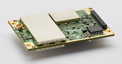
    To limit the impact of such mismatch on OSNMA operation, it is envisioned that clocks for authenticated tachographs onboard vehicles, such as the ones that will be employed for the position authenticated tachograph for OSNMA launch (PATROL) project, are reset and precisely realigned to system time in periodic workshop visits. However, the clock mismatch must satisfy the OSNMA constraint at all times between successive workshop resets, in the “holdover” period, and through all possible operating conditions, to ensure constant authenticity of the navigation message.

    In other contexts, this task is performed by such means as network synchronization protocols.

    However, we are considering a scenario where, during holdover, we cannot rely on other sources, such as an internet connection or other devices to synchronize with the reference time to assure the authenticity of our time reference and, consequently, of the PVT solution. We also cannot trust any signal received during the holdover period, thus we should not use the PVT solution to synchronize the clock.

    Here, we have two goals. First, investigate the causes of the misalignment and frequency deviation in clock generators commonly found on the market for GNSS receivers. Second, relate the clock specification parameters, taken directly from the real-time clock (RTC) device datasheets, the holdover period, and the OSNMA misalignment constraints.

    Atomic clocks at ESTEC’s Navigation Laboratory in The Netherlands independently validate Galileo timing performance. (Photo: ESA)
    Atomic clocks at ESTEC’s Navigation Laboratory in The Netherlands independently validate Galileo timing performance. (Photo: ESA)

    Frequency Accuracy and Stability

    Two metrics are usually employed to evaluate the performance of an oscillator.

    • Clock frequency accuracy is the normalized difference between the frequency output and its nominal value, f0.
    • Clock frequency stability is the normalized instantaneous frequency deviation from its local mean.

    Although devices are characterized in terms of their stability, we are interested in measuring their accuracy y(t)ΔF(t)⁄f0, where ΔF(t) is the instantaneous frequency deviation from f0 at time t. The calibration performed during each workshop reset brings the residual misalignment to a negligible value called phase calibration error. On the other hand, we will later discuss the residual frequency deviation, due to the frequency calibration error.

    The loose time synchronization requirement TL states that the authenticity of the navigation message received at time t is guaranteed if |ΔT(t)|≤TL, at every t during the holdover period.

    Finally, we can relate accuracy and misalignment using the bound

    Equation 1  (1)

    which allows us to upper bound the clock misalignment at any time t in terms of the frequency accuracy along the whole interval elapsed from the last calibration time t0.

    Accuracy Loss for Receiver Clocks

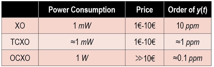
    Thanks to their affordable price and wide temperature operating conditions, quartz crystal oscillators are used for clock generation in GNSS receivers (see TABLE 1). We distinguish among simple, temperature-controlled crystal oscillators (TCXOs) and oven-controlled crystal oscillators (OCXOs). GNSS receivers typically employ TXCOs because they offer the best trade-off in terms of power consumption, price and typical accuracy.

    Table 1. Summary of the main quartz crystal oscillator characteristics.
    Table 1. Summary of the main quartz crystal oscillator characteristics.

    Sources of Frequency Accuracy Loss. Quartz crystals are piezoelectric materials, therefore any additional stresses and environmental changes generate an additional voltage, decreasing the clock stability. In the automotive scenario, the main sources of accuracy loss are temperature changes, long-term aging, and the residual calibration frequency offset, while the impact of accelerations, vibrations, gravity variation and supply voltage oscillation can safely be neglected as they result in changes of a few parts per billion.

    Currently, no analytic relationship is known between frequency accuracy and temperature for TCXOs (or OCXOs). Therefore, as reported in datasheets, the inaccuracy induced by the temperature changes is bounded by a constant value Ytemp across the whole operating temperature range. This yields a bound on the clock misalignment that increases linearly with the time from the last calibration.

    Long-term aging has significant impacts on the clock frequency accuracy and may affect the device even when it is not used for a long time (see Figure 1). A critical aspect of this effect is that it is time-variant, with the accuracy loss increasing over time.

    Figure 1. Graphical representation of the model for aging accuracy loss: upper-bound (red) versus estimated model (blue). (Image: R. Filler and J. Vig)
    Figure 1. Graphical representation of the model for aging accuracy loss: upper-bound (red) versus estimated model (blue). (Image: R. Filler and J. Vig)

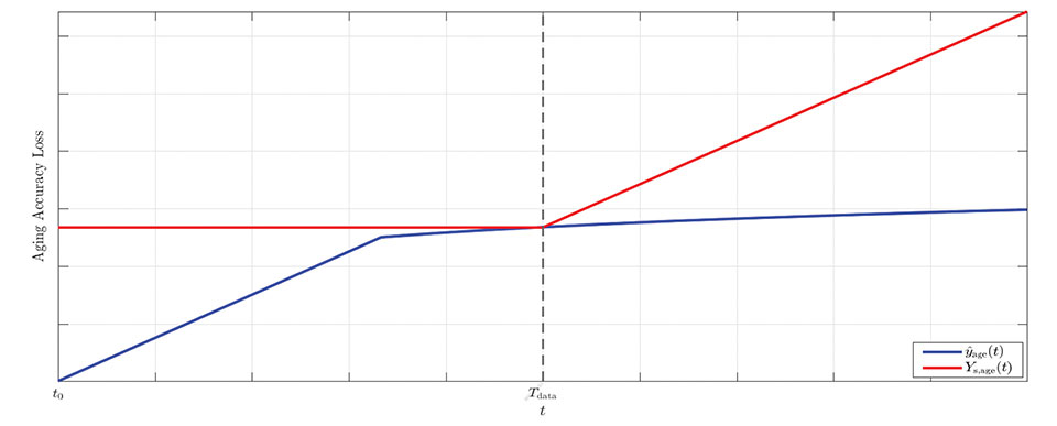
    However, datasheets typically report a single value, Yage (Tdata ), which bounds the accuracy at a fixed time Tdata.  

    The effect of long-term aging for both TCXOs and OCXOs was investigated in a 1993 study by R. Filler and J. Vig measuring the accuracies of oscillator models for several years. The study concluded that a logarithmic fit is better suited for long-term measurements, while a linear fit is better suited for initial measurements (t<30 days) and is a loose upper-bound for longer times. Because we are interested in establishing a prudential upper bound rather than a precise estimate, we use the constant upper bound Yage (Tdata) for all t<Tdata and a linear upper bound for t>Tdata. This leads to a linearly increasing bound on the time offset before Tdata, and a quadratically increasing bound after Tdata.

    Finally, the misalignment due to the frequency calibration error accumulates over time. An off-the-shelf oscillator has an initial accuracy that depends on the frequency tolerance ftol. To improve this, a precise calibration is performed, trying to synchronize the RTC with the nominal frequency f0, such as by using PTP. The contribution to the accuracy loss given by calibration can be bounded by Ycalib, a value set a priori either by system design or during the calibration process itself, yielding again a linearly increasing bound on the clock misalignment.

    Bound on the Total Misalignment. In general, the cross-correlation between the uncertainties is unknown; we can only consider the worst-case scenario where the total uncertainty is bounded by the sum of the single bounds. This choice represents a prudential and conservative approach that may yield a rather loose bound with very high probability.

    Thus, considering that all terms in the clock error bound increase over time, we can bound the total misalignment as
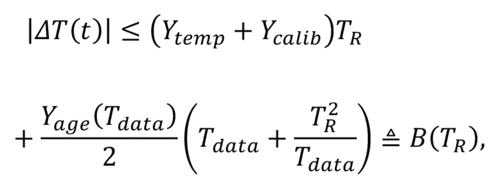
    Equation 2    (2)

    Example Values from Datasheet Specifications

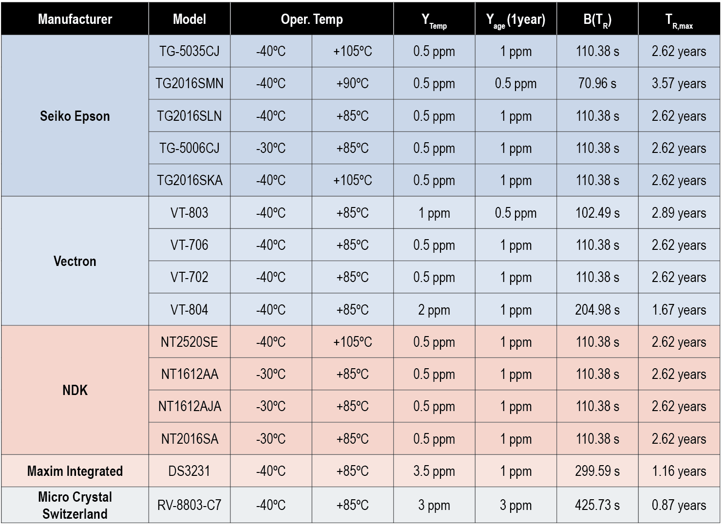
    Based on the above result, we can deem a commercial oscillator suitable for OSNMA operation if B(TR )≤TL. We can then compare the requirements for different RTCs, focusing on TCXOs designed for GNSS receivers suitable for the automotive scenario, with f0=52 MHz and a target operating temperature range between –20° Celsius and +85° Celsius. We assume that devices are subject to a calibration process, such that YcalibYtemp; thus we have neglected the calibration accuracy loss. We report in Table 2 the values of the misalignment bound, B(TR ), for TR=2 years and the maximum reset period TR,max such that B(TR,max)≤TL, with a loose time synchronization requirement TL=165s, as computed form the specs found in the datasheets. 

    Table 2. Bound values <i>B</i>(<i>T<sub>R</sub></i>) and <i>T<sub>R</sub></i><sub>,</sub><i><sub>max</sub></i> computed using several RTCs’ datasheet specs with <i>T<sub>L</sub></i>=165 s and <i>T<sub>R</sub></i>=2 years.
    Table 2. Bound values B(TR) and TR,max computed using several RTCs’ datasheet specs with TL=165 s and TR=2 years.

    Conclusions

    To ensure the authenticity of the GNSS navigation message, the Galileo OSNMA protocol requires a loose synchronization between the transmitter and the receiver. The misalignment between transmitter and receiver clock needs to be lower than a threshold TL for the whole holdover period TR. In this article, we have investigated the causes of the misalignment and frequency deviation in clock generators commonly found on the market and defined a general relationship between TL ,TR and the specifications commonly found in datasheets. Finally, we examined several mass-market temperature-controlled crystal oscillator datasheets, evaluating their performance in terms of worst-case offset bound B(TR).

    The bound represents a prudential conservative approach and may be rather loose. However, given the lack of a consistent statistical model, this is a reasonable solution. We conclude that most devices can satisfy the constraint B(TR)≤TL=165 s with a workshop reset period of TR = 2 years.

    Acknowledgements

    This study was conceived within the PATROL (Position Authenticated Tachograph foR OSNMA Launch) project, funded by the EU Agency for the Space Programme through the Fundamental Elements programme, under procurement No. GSA/OP/23/16 “Development, supply and testing of a Galileo open service authentication user terminal (OSNMA) for the GSA.”

    The authors acknowledge the invaluable support provided by the PATROL technical team: Davide Marcantonio (Qascom), Fabio Pisoni, Giovanni Gogliettino and Domenico di Grazia (ST Microelectronics), Alexandre Allien and Francois Riou (FDC), Jacques Kunegel (ACTIA), Simón Cancela Díaz and Belén Villanueva Coello (GMV).

    PATROL success was fostered by the commitment and support of Flavio Sbardellati (EUSPA Project Officer), Gonzalo Seco Granados and Alexander Rügamer (EUSPA external reviewers), Javier Simon (EUSPA reviewer), Ignacio Fernandez-Hernandez and Giovanni Vecchione (EC reviewers). The authors thank colleagues Giada Giorgi (UNIPD) and Lorenzo Dal Corso (Qascom) for reviewing this work.

    The content of this publication does not reflect the official opinion of the European Union or of the EU Agency for the Space Programme. Responsibility for the information and views expressed therein lies entirely with the authors.


    Francesco Ardizzon is a Ph.D. student and Nicola Laurenti an associate professor in the Department of Information Engineering of the University of Padova, Italy. Carlo Sarto is the head of the security engineering division and Giovanni Gamba the head of the SIGINT and EW division at Qascom S.r.l., in Bassano del Grappa, Italy.


    REFERENCES

    A. Perrig, R. Canetti, J. Tygar, and D. Song, “The TESLA broadcast authentication protocol,” RSA CryptoBytes, vol. 5, 11 2002.

    I. Fernandez-Hernandez, T. Walter, A. Neish, and C. O’Driscoll, “Independent time synchronization for resilient GNSS receivers,” in 2020 International Technical Meeting of The Institute of Navigation, 02 2020, pp. 964–978.

    I. Fernandez-Hernandez, V. Rijmen, G. Seco-Granados, J. Simon, I. Rodriguez, and J. D. Calle, “A Navigation Message Authentication proposal for the Galileo Open Service,” NAVIGATION, vol. 63, no. 1, pp. 85–102, 2016. [Online]. Available: https://onlinelibrary.wiley.com/doi/abs/10.1002/navi.125

    L. Cucchi, S. Damy, M. Paonni, M. Nicola, M. Troglia Gamba, B. Motella, and I. Fernandez-Hernandez, “Assessing galileo OSNMA under different user environments by means of a multi-purpose test bench, including a software-defined GNSS receiver,” in 4th International Technical Meeting of the Satellite Division of The Institute of Navigation (ION GNSS+ 2021), 9 2021.

    PATROL, https://www.patrol-osnma.eu/, last access 11 2021.

    “IEEE standard definitions of physical quantities for fundamental frequency and time metrology—random instabilities,” IEEE Std 1139-2008, pp. c1–35, 2009.

    J. Vig, “Quartz crystal resonators and oscillators for frequency control and timing applications – a tutorial,” in IEEE International Frequency Control Symposium Tutorials, 2016.

    M. Lombardi, “Fundamentals of time and frequency,” in The Mechatronics Handbook, CRC Press, 01 2002, ch. 17.

    J. Cartright, “Aging performance on crystals,” http://www.conwin.com/pdfs/aging perf crystals.pdf, 2008.

    R. Filler and J. Vig, “Long-term aging of oscillators,” IEEE Transactions on Ultrasonics, Ferroelectrics, and Frequency Control, vol. 40, no. 4, pp. 387–394, 1993.

    W. Riley and D. Howe, Handbook of Frequency and Stability Analysis. Special Publication (NIST SP), National Institute of Standards and Technology, Gaithersburg, MD, 2008-07-01 00:07:00 2008.

    “Performance specification: oscillator, crystal controlled, general specification for,” MIL-PRF-55310F, 2018.

    “Fundamentals of quartz oscillators, application note 200-2,” http://leapsecond.com/hpan/an200-2.pdf, last access November 2021.

  • Quectel’s new Android smart module integrates with GNSS

    Quectel’s new Android smart module integrates with GNSS

    Photo: Quectel
    Photo: Quectel

    Quectel Wireless Solutions has launched the SG865W-WF, a new generation of flagship Android smart module. The module is equipped with Qualcomm’s QCS8250 system-on-chip (SoC), which offers powerful performance and rich multimedia functions to meet industrial and consumer artificial intelligence IoT (AIoT) scenarios.

    Quectel made the announcement at the Consumer Electronics Show (CES) taking place this week in Las Vegas.

    With various peripheral interfaces such as dual USB, multiple PCIe and UART, the product can seamlessly integrate with cellular and GNSS modules such as Quectel’s EC20 LTE module, and the RG500Q 5G module, allowing customer terminals to be connected flexibly to 4G/5G networks and achieve faster and more accurate positioning.

    The SG865W-WF module will accelerate the efficient deployment of high-end AIoT applications such as video conferencing, cloud gaming, digital signage, unmanned aerial vehicles (UAVs), robots and smart retail.

  • SBG Systems provides major firmware update for its INS

    SBG Systems provides major firmware update for its INS

    Image: SBG Systems
    Image: SBG Systems

    SBG Systems has released a major firmware update for all its high-performance inertial navigation systems (INS), including its Ekinox, Apogee, Navsight and Quanta brand sensors.

    Developed in collaboration with customers, firmware 4.0 provides new features and is designed to make integration easier for system designers. It aims to provide improvements in these areas:

    System accuracy and robustness

    • Enhanced heading in a single antenna allows for easier UAV survey operations.
    • Improved GNSS antenna auto lever arm calibration provides a faster and easier system setup.

    Easier system integration

    • New PTP and NTP features for time synchronization eliminate the need and cost of an external timing module.
    • An integrated NTRIP client eases access to NRTK/VRS correction services.
    • A logged RTCM raw stream eases post-processing in SBG Systems’ post-processing software Qinertia using the user’s NRTK/VRS data.
    • A new Access Rights Management System sets up specific user roles.
    • Two serial outputs have been added on Navsight and Quanta for advanced survey setups.
    • REST API has been introduced for power users and integrators.

    Learn more and download the firmware 4.0 on the SBG Systems website.

  • Tallysman adds new signal support to TW7000 antennas

    Tallysman adds new signal support to TW7000 antennas

    Photo: Tallysman
    Photo: Tallysman

    Tallysman Wireless Inc. has added the TW7976 to its surface mount line of antennas. The TW7976 covers GPS/QZSS-L1/L2, QZSS-L6, GLONASS-G1/G2, Galileo-E1/E6, and BeiDou-B1/B3, as well as L-band correction signals.

    The addition of L6 and E6 coverage supports the Galileo High Accuracy Service (HAS) and the QZSS Centimeter Level Augmentation Service (CLAS) correction signals. Regional augmentation services such as WAAS (North America), EGNOS (Europe), MSAS (Japan), GAGAN (India) and high-precision L-band correction services are also supported.

    The TW7976 features a patented Tallysman Accutenna, which provides multi-constellation and multi-frequency support. Accutenna technology offers an excellent axial ratio that mitigates multipath signals and produces clean code and phase measurements. Accutenna antennas enable high-precision techniques, such as real-time kinematic (RTK) and precise point positioning (PPP), which provide accurate and precise position estimates (< 0.1 m).

    Another key feature of the TW7976 is a deep pre-filter that attenuates out-of-band signals. This is crucial in challenging urban environments where near-band and inter-modulated signal interference from LTE and other cellular bands is common.

    The surface-mounted TW7976 weighs 180 grams, is IP67-rated, and supports direct screw, magnet or adhesive-tape attachment. The TW7976 is ideal for many applications, including autonomous vehicle navigation (land, rail, sea, and air) and high-precision automotive and agricultural positioning.

  • Peering inside the box: A close look at GNSS OEMs

    Peering inside the box: A close look at GNSS OEMs

    OEM boards — the beating heart of the industry — power an ever-growing list of applications.

    JAVAD GNSS Ready for Lift-Off

    New Leaders and Markets

    JAVAD Board Guides ESA Vega Mission

    GNSS Makers Share Insights: OEMs Discuss Their Boards, Markets and Company Growth


    “Original equipment manufacturer (OEM)” is a widely used but poorly defined term. In general, it refers to a manufacturer that provides components or sub-assemblies to another one for use in the latter’s end products. In the GNSS industry, the purchasers of OEM boards typically are manufacturers of products that require positioning or navigation capabilities, such as guidance systems for tractors, UAVs or automobiles. Sometimes, such manufacturers integrate the OEM GNSS receivers with other sensors, such as inertial measurement units and lidar devices. Often, the OEM also will provide technical support to the integrator.

    Much of the OEM business is not visible to the end user of the equipment that contains OEM components, let alone to the casual observer, because those components are “inside the box,” such as a guidance system, and “the box,” in turn, is under the hood or in some other hidden place. There is almost never a sticker on the outside analogous to the one that says “Intel inside” on many computers to distinguish the Intel CPU inside from, say, an AMD processor. Furthermore, OEM sales are typically obscured by confidentiality provisions in OEM licensing agreements that also address issues of branding, payment, quality assurance, and the timing of deliveries.

    Integrators can choose from a wide variety of OEM GNSS boards depending on their intended use; the environment in which they will operate; their performance requirements; and their size, weight, power consumption and (of course) cost. OEM GNSS boards range from development kits that assist users to integrate GNSS into their product design to differential, multi-frequency, and, increasingly, multi-constellation boards.

    In the following pages, six GNSS OEM manufacturers address these questions:

    • How do you define OEM?
    • What distinguishes your latest generation of OEM receiver boards from previous ones?
    • What are the markets for your GNSS OEM receiver boards? Which ones are growing the most?

    Additionally, each one showcases a product.


    JAVAD GNSS Ready for Lift-Off

    JAVAD GNSS has been transitioning to a new position in the market since the passing in May 2020 of its founder, president and CEO Javad Ashjaee, a giant of the GNSS industry. For several decades, the company eschewed mass production for such markets as the automobile industry and cellular phones, choosing instead to focus primarily on high-accuracy surveying applications.

    “Our founder really loved the surveying market, created a lot of technology, and drove the rest of the industry through the evolutionary process to where it is today,” said Tom Hunter, the company’s chief sales officer. “You can see a little bit of JAVAD GNSS in just about any GNSS-based land survey product on the market today.”

    At the heart of each of JAVAD GNSS’ OEM boards is a proprietary ASIC. The boards it sells are the same ones it uses in its own reference stations, land survey products and marine systems, Hunter said. Aerospace is a key focus, an industry that requires very high accuracy, precision and reliability despite operating in environments of extreme shock, vibration, acceleration and temperatures.

    Photo: Javad GNSS
    Photo: Javad GNSS

    “Our successes have been in working with many of the companies that build these very large launch vehicles used to carry heavy payloads into orbit,” Hunter said. “Our customers are companies such as Orbital, Northrop Grumman and SpaceX.” Those heavy-duty launch vehicles, he pointed out, must also follow a pre-described flight path. “You don’t want to start another world war because another country sees something heading its way.”

    Tracing All Components. JAVAD GNSS’ boards “have complete component traceability,” Hunter said. The company does not buy any of its components from brokers. “We have to buy either directly from the manufacturer or from the manufacturers’ designated distributor, and it has full part traceability in our own factory in San Jose, California.” Should a component ever fail, the company could quickly trace when and where it was made. “That’s very important when we’re dealing with customers such as NASA, the Air Force or Boeing, because the safety of flight depends upon the performance and the quality of the product.”

    The company will soon supply a receiver that will spend about four and a half to five years in orbit on a cluster of small low-Earth-orbit satellites, Hunter said. (See “JAVAD Board Guides ESA Vega Mission” below.)

    To make sure none of its products are exported illegally from the United States, JAVAD GNSS also traces where each one ends up. “We know where every one of those boards is.”

    JAVAD GNSS must guarantee its aerospace customers, which have invested millions of dollars in designing their systems, that each model of its devices will remain exactly the same. Hence, it bought from some manufacturers their entire inventory of certain components, in case they discontinued making them, and certifies each

    JAVAD GNSS’ products are more expensive than those from other manufacturers because they are better, Hunter claimed. “We use really high-performance, temperature-compensated oscillators in our boards to make sure we have precise timing. We use a custom ASIC that we designed and built. Our receivers have 864 channels, so they can receive just about anything broadcast in the L-band.” The company constantly upgrades its devices to match modernization of the signal structures.

    “I can remember when the rest of the industry was saying, ‘You have a 12-channel GPS receiver? You’re nuts! I mean, who uses that much information?’,” Hunter recalled. “Today, we’re using every signal that comes out of GPS, whether it be L1, L2, L5, L1C, and the same thing with all of the GNSS constellations.” For example, when Japan will begin to broadcast its new QZSS signal soon, “we’re ready not only to find it, but to track it, decode it, and utilize it for position and timing solutions.” Anti-jamming and in-band interference rejection are standard in JAVAD GNSS’ products, while those from other manufacturers require external filtering or different types of antennas, Hunter pointed out.


    New Leaders and Markets

    After Javad Ashjaee — JAVAD GNSS’ founder, president and CEO — died in May 2020, Tom Hunter, who co-founded Ashtech with Ashjaee in 1987, returned to the company after a five-year retirement.

    “He left the company with an awful lot of technology, a lot of patents, and a lot of people who knew how to design and build products, not only for today, but for the future,” Hunter explained. “They needed some guidance.”

    So, in January, Nedda Ashjaee — Javad Ashjaee’s daughter and his close collaborator for the previous 25 years — and the board of directors asked Hunter to rejoin the company. “They said that they wanted me to help them make sure that we can be on a path where we can use our core technologies and enter into new market segments and new marketplaces.”

    Hunter added, “We made some changes to how we introduce surveying products into the marketplace.” The company no longer sells its products directly to end users. Rather, it goes through a new process and channel for getting products into the marketplace. It also brought on board a new chief technology officer this summer who will be driving engineering efforts. “We are becoming market driven. And to do that we needed to expand our marketing, sales and engineering capabilities. We are changing every aspect of the company,” Hunter said.

    JAVAD GNSS actually consists of two companies in San Jose: JAVAD GNSS, which designs, markets and sells products, and JAVAD GNSS EMS, which manufactures them. It also has a presence in Moscow — the company hired many engineers following the collapse of the Soviet Union, many of whom had worked on GLONASS. “Javad looked at that as an opportunity to hire them and use them to develop a multiple constellation receiver,” Hunter recalled. However, as a subcontractor for U.S. government projects, it is much easier for JAVAD GNSS to operate on U.S. soil with engineers who are U.S. citizens. “We’re expanding our San Jose operation to include on-site engineering development, not only in RF, but also in digital signal-processing software.” The company will continue to receive schematics from its Russian subsidiary. “Instead of exporting technology, we’re importing it.”

    JAVAD GNSS is now moving into markets that did not interest Javad Ashjaee. It recently launched new products in the machine control, marine navigation and accurate heading markets, as well as the agricultural and construction markets, with integrated sensors that can be readily installed on various machines. Other GNSS manufacturers have been producing such devices for decades, Hunter acknowledges. However, he adds, “ours will be able to use multiple sources not only for satellite- and terrestrial-based corrections, but a combination of those.”


    A JAVAD OEM GNSS board is at the heart of the navigation system of the Vega space vehicle developed by the European Space Agency to launch small satellites into low Earth orbit. It provides great flexibility of mission at an affordable cost and represents the European solution for space accessibility. (Photo: Avio, Italy)
    A JAVAD OEM GNSS board is at the heart of the navigation system of the Vega space vehicle developed by the European Space Agency to launch small satellites into low Earth orbit. It provides great flexibility of mission at an affordable cost and represents the European solution for space accessibility. (Photo: Avio, Italy)

    JAVAD Board Guides ESA Vega Mission

    A JAVAD OEM GNSS board is at the heart of the navigation system of the Vega space vehicle developed by the European Space Agency (ESA). ESA developed Vega to launch small satellites into low Earth orbit. It provides great flexibility of mission at an affordable cost and represents the European solution for space accessibility.

    The JAVAD OEM GNSS board is embedded in the gle/RGU/G2T/HDA/MB1 for space missions. (Photo: GreenLake Engineering)
    The JAVAD OEM GNSS board is embedded in the gle/RGU/G2T/HDA/MB1 for space missions. (Photo: GreenLake Engineering)

    The JAVAD OEM GNSS board is embedded in the gle/RGU/G2T/HDA/MB1 — a cost-effective, high-performance, compact and rugged GNSS receiver specifically designed and environmentally qualified. Installed on the upper stage of the VEGA launcher, it allows accurate trajectory verification during the entire flight mission. 

    ESA’s initial request was for a GNSS unit built with commercial off-the-shelf components, thus maintaining low costs, but which could still operate in the extreme vibration and shock conditions typical of a space launcher. After an initial feasibility analysis, GreenLake Engineering — a subsidiary of Instrumentation Devices — developed the unit mechanically and electronically to satisfy ESA technical specifications. Its biggest challenge was to pass ESA’s extensive qualification and quality process.

    For many years, Instrumentation Devices (based in Como, Italy) and JAVAD GNSS have been partners. Instrumentation Devices sub-contracted for the Vega project with Avio (based in Colleferro, near Rome), which is the prime contractor with ESA. Avio is an international group that designs and produces space launchers and both liquid and solid propulsion systems for space transportation. 

    ESA supervised the project and is responsible for all activities relating to flight safety and qualification of the equipment installed on board. JAVAD GNSS supported GreenLake Engineering with the integration and low-level configuration of the OEM board for this challenging application.


    A Massey Ferguson tractor guided by a NovAtel GNSS OEM receiver. (Photo: Hexagon | NovAtel)
    A Massey Ferguson tractor guided by a NovAtel GNSS OEM receiver. (Photo: Hexagon | NovAtel)

    GNSS Makers Share Insights 

    OEMs Discuss Their Boards, Markets and Company Growth 

    headshots

    Five prominent GNSS original equipment manufacturers discuss their current products and future markets.

    How do you define OEM?

    While all six manufacturers agree on the general definition of OEM given above, they focus on different aspects. OEM customers of JAVAD GNSS “require reliable, accurate and stable high precision measurements for positioning and timing,” Hunter said.

    The performance of OEM products from Hexagon | NovAtel reflects on its customers and itself, Gerein said. “Our OEM receiver cards are selected, valued and relied upon as the core positioning elements in many applications across vertical markets. We offer full rebranding options with custom logos, colors and industrial designs to seamlessly integrate our technology into their offerings.”

    At Trimble, OEM customers “combine Trimble’s GNSS technology with their domain expertise to deliver solutions to the end customer,” Norse said.

    For Hemisphere GNSS, OEM clients can range “from a tinker/maker hobbyist working with GNSS, to a large multinational organization designing navigation solutions for global clients,” Burnell said, but the company looks at all of them “in the same light.” Additionally, “Some OEM clients have all the tools they need already built into the Hemisphere products, while others come to us looking for advanced or custom features to help set their products apart in the market.”

    Septentrio has a worldwide support team that assists its OEM clients “in all the stages of their integration process, from validation to product release,” Freulon said.

    What distinguishes your latest generation of OEM receiver boards from previous ones?

    Septentrio’s most recent OEM receiver boards integrate the latest Septentrio GNSS and INS technology and algorithms. AsteRx-m3 OEM receiver boards use all GNSS constellations, can track all available satellites, and can be used as a base station to deliver RTK corrections or as a rover with a single or dual antenna.

    Improvements include lower power consumption, increased security with secure boot, and greater resilience with anti-jamming and anti-spoofing. Its new receiver boards, Freulon said, “are backward compatible with extended capabilities of the latest GNSS signals and several variants of the inertial navigation system.” Upcoming software releases will include Galileo’s free High Accuracy Service (HAS) as well as OSNMA, the latest anti-spoofing mechanism.

    Trimble’s latest generation of OEM GNSS boards are based on Trimble Maxwell 7 technology, which features the company’s seventh-generation baseband GNSS ASIC (application-specific integrated circuit). Trimble designed the Maxwell family of products to maximize the quality of observables derived from available signals transmitted from all GNSS constellations as well as satellite-based augmentation systems, Norse explained. This results in stronger signals, greater availability, reduced power consumption, advanced multipath mitigation and protection against spoofing.

    The boards also run Trimble’s ProPoint positioning engine, which improves performance in challenging environments such as tunnels, urban canyons and tree canopies and provides continuous RTK using a base station or Trimble RTX correction services delivered via cellular or satellite connections.

    JAVAD GNSS’ latest OEM products are “more cost effective” and integrate an IMU with an 874-channel multi-GNSS band module with up to 200Hz positioning and data output. “All are still proudly made in the United States,” Hunter said.

    NovAtel’s OEM7 receiver boards feature added options for interference robustness and situational awareness “to help protect the user’s GNSS signals from an increasingly crowded RF spectrum and growing jamming and spoofing threats,” Gerein said. The company enhanced the sensor fusion capabilities with SPAN GNSS+INS technology, enabling a deeply coupled integration with IMUs that strengthens positioning through GNSS interruptions and allows the rapid reacquisition of signals post-outages. The boards are compatible with PPP TerraStar Correction Services “for precise positioning anywhere in the world.”

    Hemisphere GNSS’ Phantom and Vega series of OEM board products can track all L-band GNSS signals, enabling the company’s OEM clients to upgrade the capabilities of their integrations and “tap into the performance of multi-GNSS, multi-frequency RTK and Atlas PPP solutions,” Burnell said.

    The boards consume less power than the previous generation and introduce Hemisphere’s Cygnus automatic interference mitigation technology, which monitors the GNSS signal bands for interference and automatically deploys filters “with no need for integrators or users to understand signal theory,” Burnell explained. Cygnus, which turns off the filters when the interference fades away, is “automatic interference mitigation for the masses.”

    What are your markets for your GNSS OEM receiver boards? Which ones are growing the most?

    NovAtel said its receiver cards are highly configurable and integrate easily across a wide range of markets, including survey, mobile mapping, agriculture, defense, marine and autonomous platforms for both on- and off-road applications.
    In particular, the company’s OEM7 cards “uniquely support the defense market and their requirements for increased protection against jamming and spoofing in mission-critical applications.” The cards also “meet the positioning availability and increasingly rigid product quality standards required in agriculture, automotive and autonomous system markets.”

    Trimble lists precision agriculture, construction, mining, forestry, autonomous vehicles, port automation, distribution centers and mobile mapping among the uses of its GNSS OEM receiver boards. “We are seeing growth in markets where reliable, robust and high-precision positioning is required for a solution such as autonomous platforms,” Norse said.

    Septentrio reports growing demand for its mosaic GNSS modules “due to their small footprint and impressive performance.” OEM boards, Freulon said, “remain very popular for applications where a quick integration is needed or where ultimate performance is expected.”

    However, the most important markets for its OEM boards remain “UAV, together with industrial-grade automations in agriculture, construction or logistics.”

    Septentrio sees an increase in “the number of positioning and mapping systems that require the ultimate performance of our receivers, especially when combined with other sensors,” Freulon said. In particular, he cites the performance of its single- and dual-antenna AsteRx-m3 receiver boards and of the AsteRx3i INS boards, which “provide a solution which combines industrial-grade IMU and GNSS all on a single OEM board, greatly simplifying the integration process in systems where both positioning and orientation are needed.”

    Hemisphere GNSS, which has a significant OEM presence in the agriculture, marine, survey and GIS markets, reports seeing growth in several markets. “We have seen significant growth in all aspects of autonomous integrations, from ground vehicles for on-road or off-road, to in-flight applications with UAVs, to maritime applications focusing on dynamic positioning in both nearshore and offshore environments,” Burnell said. “There is a recognition that using precision navigation equipment benefits everyone and protects our environment through efficiencies of operation, either in resource management or by improved operational capacity.”

    JAVAD GNSS lists maritime positioning and docking, timing, launch vehicle positioning and range safety, autonomous vehicle testing, in orbit positioning and drone guidance among the markets for its OEM receiver boards, with space-related applications the fastest growing market.

    OEM7700. (Photo: Hemisphere GNSS)
    OEM7700. (Photo: Hemisphere GNSS)

    Briefly describe one of your GNSS OEM receiver boards.

    The OEM7700 receiver card from NovAtel is used in agricultural auto-steering applications. “The OEM7700 can receive all GNSS constellations across all frequencies, enabling a highly available position,” Gerein said. “When combined with TerraStar corrections and our SPAN GNSS+INS technology for sensor fusion applications, the OEM7700 ensures highly precise positioning scalable from meter- to centimeter-level accuracy.”

    OEM7700 receiver boards help the company’s agriculture customers “solve the positioning challenge of repeatable pass-to-pass accuracy for auto-steering,” Gerein said. Plus, the card meets their strict environmental requirements for agriculture vehicles.

    Photo: iXblue
    Photo: iXblue

    Septentrio’s OEM client iXblue uses the company’s AsteRx OEM boards inside its Atlans A7 positioning and orientation system. “Atlans A7 was developed in close cooperation with Septentrio and is designed to provide continuous and accurate positioning in urban environments,” Freulon said.

    Atlans A7 combines iXblue’s inertial navigation system (INS), which is based on a fiber-optic gyroscope (FOG), with Septentrio’s multi-frequency GNSS receiver technologies. To develop this INS-GNSS mobile mapping solution, experts from iXblue and Septentrio worked closely with the aim to develop a smart coupling method that combines the advantages of the two companies’ technologies. The same smart coupling technique is also applied in the post-processing software for an optimal result. The main advantage of Atlans A7 is to maintain a high heading precision in any circumstance, which “allows precise georeferencing for both land and air applications and drastically limits the drift during GNSS outages,” Freulon said.

    Photo: Trimble
    AX940. (Photo: Trimble)

    At Trimble, Norse cites the case of an agribusiness company that wanted to make its robotic tractors able to drive autonomously, requiring centimeter-level positioning and orientation at high update rates in challenging environments. The company chose the Trimble AX940i because of its “combination of GNSS and inertial technology in an easy-to-install smart antenna.” The Trimble ProPoint engine tightly couples the onboard IMU sensor data with the GNSS observations to provide up to 100-Hz outputs utilizing the NMEA-2000 standard or other interfaces. Additionally, Trimble VRS Now service provides instant access to RTK corrections and an operator can use the built-in Wi-Fi to configure and monitor the receiver from nearby.

    The HydroBoard II flotation platform contains the RiverSurveyor M9 acoustic device, which measures the flow rates of rivers, streams and irrigation canals. (Image: Hemisphere GNSS)
    The HydroBoard II flotation platform contains the RiverSurveyor M9 acoustic device, which measures the flow rates of rivers, streams and irrigation canals. (Image: Hemisphere GNSS)

    Hemisphere GNSS’ Phantom 34 RTK receiver and antenna is employed by SonTek in its RiverSurveyor M9 product used by water districts and the U.S. Geological Survey to help monitor and manage water resources. The M9 is one in a series of SonTek products focused on determining flow rates for rivers, streams and irrigation canals. It consists of a small flotation platform with an acoustic doppler current profiler that measures the flow rate of the water column underneath it, a data telemetry system, and the Phantom 34 RTK to pinpoint the data collected.

    The platform is floated from shore to shore across a channel using a tether, measuring along the way. “Using RTK simplifies collecting measurements as the survey will have continuous velocity profile measurements the entire way across the waterway,” Burnell said.

  • Harxon offers two new GNSS antennas for intelligent vehicles

    Harxon offers two new GNSS antennas for intelligent vehicles

    Harxon is offering two new GNSS antennas for intelligent connected vehicles (ICV). ICVs are equipped with advanced sensors, controllers, actuators and other devices. They are enabled for  intelligent information exchanges between the vehicle and everything (car, road, people, cloud), technology known as V2X.


    The ICV antennas connect autos with GNSS, 5G, Wi-Fi, ultra-wideband  and more. Both highly integrated high-performance multiband automotive antennas provide swift, reliable connectivity to meet the increasing demands of seamless communication experience for intelligent transportation system (ITS) applications.

    The integrated antennas support dedicated short-range (DSRC) and cellar vehicle-to-everything (C-V2X) communication. The antennas embed a premium GNSS antenna with high gain for consistent and reliable precise positioning service. They also allow for multiple input and output of data to achieve swift internet download speed in 5G networks.

    The Harxon HX-AULT002. (Photo: Harxon)
    HX-AULT002. (Photo: Harxon)

    The Harxon HX-AUST002 is designed to connect unmanned passenger vehicles to networks, clouds, other vehicles, and ITS roadside infrastructure.

    The Harxon HX-AULT002 is designed for unmanned commercial vehicles, including short-distance delivery vehicles, mainline logistic heavy-duty trucks, and intercity shuttle buses.

    The versatile antennas are suitable for integration in on-board units (OBU), intelligent roadside units, chipsets and Tier 1 automobiles.

  • UAV company AgEagle to acquire senseFly from Parrot

    UAV company AgEagle to acquire senseFly from Parrot

    AgEagle will acquire senseFly, a Parrot Group subsidiary, for US$23 million.

    AgEagle Aerial Systems Inc. is a a provider of drones, sensors and software, and Parrot is a European drone company. Founded in 2009, senseFly develops and produces a proprietary line of eBee-branded, high performance, fixed wing drones for professional use.

    Photo: SenseFly
    The eBee Geo drone was introduced in March. (Photo: SenseFly)

    The development positions AgEagle to provide a full-stack fixed-wing drone solution for agriculture, government, engineering and construction, among other industry verticals. SenseFly also brings to AgEagle solid engineering talent focused on advanced research and development, a well-established global reseller network, and a strong portfolio of intellectual property, AgEagle stated in a press release.

    The eBee drones are designed to be safe, ultra-light and easy to use. They are in use by thousands of customers around the world in agriculture, government, engineering and construction to collect aerial data. Headquartered in Lausanne, Switzerland, senseFly employs 90 people, generating total annual revenues of US$12.5 million in 2020.

    “Recognized as the producer of the world’s most widely used fixed wing drones, senseFly is an ideal strategic fit for AgEagle,” said Brandon Torres Declet, chief executive officer of AgEagle.

    Moving forward, Parrot will focus its expertise and resources on the growth of its professional quadcopter drone equipment and drone data analysis software activities, according to Parrot founder and CEO Henri Seydoux. “The transaction will provide additional cash and lower operational expends to drive Parrot’s growth and industry standing,” Seydoux said. “With the capabilities of the ANAFI line of professional drones and of the Pix4D software suites, Parrot will continue to address its core market segments: 3D mapping, surveying and inspection, agriculture, and defense and security.”

    In tandem with the closing of the acquisition, which is expected shortly, Labossiere will resign as CEO of senseFly. Michael O’Sullivan, who previously served as the company’s head of global marketing, will be appointed managing director of the new AgEagle subsidiary. All other senseFly employees will retain their current responsibilities.

    For details relating to the terms and conditions of the acquisition, refer to the Form 8-K to be filed by AgEagle with the U.S. Securities and Exchange Commission upon closing of the transaction and accessible at www.sec.gov.

  • Microdrones updates mdCockpit app for safer drone surveying

    Microdrones updates mdCockpit app for safer drone surveying

    Screenshot: Microdrones
    Screenshot: Microdrones

    The mdCockpit app from Microdrones was designed for professional drone users to make it easy to plan, monitor, change and control flights from an Android tablet.

    The latest updates — in mdCockpit 2021.3 — include new features that improve flight safety and give more options for surveying in an aim to deliver a premier solution for planning, monitoring, adjusting, analyzing and controlling professional drone flight missions right from a tablet. Robert Chrismon, the marketing manager, and Maude Morin, Software Product Owner discuss the updates  in the video below.

    Key updates for mdCockpit version 2021.3 are in the Flight Editor, Flight Data and Drone Configuration components of the app.

    FLIGHT EDITOR

    • New layers section in Mission Dashboard
    • KML as a background layer
    • Optimized entry point on corridors

    FLIGHT DATA

    • Displays last position of the drone
    • Drop renamed to Descent in Quick Height Change dialog
    • Telemetry alerts

    DRONE CONFIGURATION

    • New maintenance program fields in drone config
    • Reminder of the next inspection or service
    • Read only homing height

    Drone pilots can download mdCockpit onto their Android table through the Google Play store.

  • U-blox releases u-center 2 GNSS evaluation software

    U-blox releases u-center 2 GNSS evaluation software

    Screenshot: U-blox
    Screenshot: U-blox

    U‑blox has launched its new GNSS evaluation software, u-center 2. The software, which runs on Microsoft Windows, offers anyone working with 10th-generation (M10) u‑blox GNSS technology a highly intuitive interface to configure GNSS products, evaluate their performance, improve the quality of their software, and experience the performance boost achieved using GNSS-related services.

    U-center 2 is the successor to the u-center GNSS evaluation software, which has been used by design engineers for almost two decades to develop GNSS receiver applications. Compatible with u‑blox M10 GNSS technology, u-center 2 is designed to offer improved performance over its predecessor, as well as new features that simplify configuration, evaluation and software development of GNSS-based solutions.

    Screenshot: U-blox
    Screenshot: U-blox

    U-center 2 provides personalized workspaces with adaptive window elements offering a choice of views to observe static and dynamic behavior of the connected GNSS receiver. The built-in log player, which accepts log files from the previous version of the software, features easy message- and time-based navigation and lets users set the playback speed, making development of end products more efficient. Automatic updates ensure that the software includes the latest features with minimal user effort.

    U-center 2 simplifies the evaluation of GNSS-related location services such as AssistNow, through which GNSS receivers gain access to GNSS aiding data, enhancing startup performance, and saving power.

    Predecessor u‑center will continue to be the go-to solution for GNSS solutions based on earlier technology platforms.

    “We are confident that users will immediately recognize how easy u-center 2 makes it to set up and evaluate the latest generations of our GNSS chips and modules,” said Bernd Heidtmann, product manager, Product Strategy for Standard Precision GNSS, u‑blox. “With its fresh and minimalist user interface, the upcoming quick product configuration designed for key use cases, and optimized data logging, u-center 2 will raise the benchmark for GNSS evaluation tools in terms of performance and user experience.”

    U-center 2 is free for download.

  • Thank you for registering

    Thank you for registering for the upcoming webinar, “How Inertial+GNSS technology enhances autonomous navigation with Autoware and RT Maps eco-systems” sponsored by SBG Systems.

    A link to the live event will be sent to you two hours before the event. Your personalized event URL will be automatically generated by the ON24 system. To ensure receipt of the email, please whitelist this email address by adding it to your contacts: [email protected].

    This presentation will begin at 11 a.m. EDT / 8 a.m. PDT on Thursday, October 28.  A recording will also be sent to you the following day so you can watch it on-demand.

    Audience members may arrive 15 minutes prior to live time. If you have any questions, please contact event producer Mackenzie Shoemaker at [email protected].

  • Telit launches SE150A4 series with GNSS for internet of things

    Telit launches SE150A4 series with GNSS for internet of things

    Photo: Telit
    Photo: Telit

    Telit has launched the SE150A4 system-on-module series with an embedded multi-constellation GNSS (GPS, BeiDou, GLONASS and Galileo) receiver for high-performance positioning and navigation.

    The SE150A4 module is designed for retail and point-of-service (POS) devices, home automation and security, law enforcement and other applications that need high data rates, advanced human-machine interfaces and edge-computing functionality. It features the Android OS and the Qualcomm QCM2150, and is designed to serve internet of things (IoT) device makers and customers.

    With LTE Category 4 for maximum data rates of up to 150 Mbps downlink and 50 Mbps uplink, the SE150A4 series is designed for bandwidth-intensive applications such as live, high-definition (1080p/30 fps) video from law enforcement cameras, home security systems and robots. Along with GNSS, Wi-Fi (802.11a/b/g/n) and Bluetooth Low Energy (BLE) 4.2 provide additional connection flexibility.

    The SE150A4 series provides native support for integrated peripherals such as high-resolution touch displays, advanced cameras, sensors and audio interfaces, as well as SDIO 3.0, USB 2.0, UART, SPI and I2C digital interfaces. Android OS gives device OEMs, systems designers and other users access to a vast developer community and broad selection of tools and ready-to-use software components.

    The modules are available in two versions.

    • The SE150A4-NA for North America supports 13 LTE bands, including Band 14 for AT&T FirstNet Band and Bands 66 and 71 for T-Mobile, as well as 3G fallback.
    • The SE150A4-EU for Europe and the rest of the world supports Band 28 and nine additional LTE bands, as well as 2G/3G fallback.

    At 40.5 x 40.5 mm, the LCC +LGA form factor allows easy integration in portable, wearable and handheld devices, including mobile point-of-sale terminals, medical monitors, industrial PDAs and telematics cameras. The modules are also suitable for fixed applications such as smart-home gateways and alarm systems.

  • Thank you for registering

    Thank you for registering for the upcoming webinar, “Measuring PNT Performance in Challenged Environments” sponsored by Orolia.

    A link to the live event will be sent to you two hours before the event. Your personalized event URL will be automatically generated by the ON24 system. To ensure receipt of the email, please whitelist this email address by adding it to your contacts: [email protected].

    This presentation will begin at 1 p.m. ET / 10 a.m. PT on Thursday, November 4.  A recording will also be sent to you the following day so you can watch it on-demand.

    Audience members may arrive 15 minutes prior to live time. If you have any questions, please contact event producer Mackenzie Shoemaker at [email protected].