Category: Uncategorized

  • Inertial Labs releases INS-DU GPS-aided unit for high-accuracy positioning

    Inertial Labs releases INS-DU GPS-aided unit for high-accuracy positioning

    The new INS-DU delivers high-accuracy RTK positioning for air, land and marine applications

    Photo: Inertial Labs
    Photo: Inertial Labs

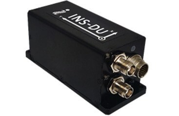
    Inertial Labs has released a new GPS-aided inertial navigation system (INS). The INS-DU is a high-performance strapdown system that determines position, velocity and absolute orientation to any platform it is mounted to.

    The INS-DU has a dual-antenna u-blox GNSS receiver that provides 1-cm real-time kinematic (RTK) position from RTCM 3 RTK corrections and supports a wide range of GNSS constellations.

    Designed for UAVs, land vehicles and marine vessels, the INS-DU is an effective, low-cost solution that uses a range of aiding data for different applications. With highly accurate navigation in GNSS-denied environments, the INS-DU delivers a cost-effective GNSS-denied solution, according to Inertial Labs.

    One of the key elements to the success of the INS-DU is its use of the miniAHRS, which utilizes 3-axes each of precision magnetometers, accelerometers and gyroscopes to provide orientation of the device under measure. It contains cutting-edge algorithms for the motion of robots, unmanned and autonomous vehicles, and antennas.

    MiniAHRS mini fluxgate magnetometers have an advantage over commonly used magneto-inductive or magneto-resistive alternatives and have been a trusted North reference for more than 70 years.

    The INS-DU provides a full navigation solution for both GNSS and GNSS-denied environments. With custom interfaces and a power consumption of two and a half of a Watts, the INS-DU is a versatile solution fit for a wide variety of users with power consumption restrictions.

    In addition, the INS-DU contains our on-board sensor-fusion filter, state-of-the-art navigation, and guidance algorithms and calibration software.

  • Global trends in the mapping industry during the pandemic

    Photo: SimActive
    Photo: SimActive

    By Philippe Simard, Ph.D.
    President, SimActive Inc.

    The COVID-19 pandemic has brought uncertainties to all businesses, and the mapping industry has been no exception.

    Slowdowns were observed during the first few months of 2020 as lockdowns were gradually enforced in Asia, then Europe, and finally the Americas.

    As expected, projects were delayed during that initial period as companies were reorganizing their operations to allow for remote work.

    Once that transition was overcome, a great number of projects resumed, and the geospatial field has been gradually coming back to normal since then. That can be explained by different factors, including, for example, several governments accelerating infrastructure projects to stimulate the economy.

    A lot of mapping firms have turned the pandemic into an opportunity to improve their processes. Slower times allow reviewing production workflows and assessing bottlenecks. Once identified, new hardware and software solutions can be evaluated to optimize production.

    Interestingly, the resulting investments into new solutions has been significant. Companies are seeing a quick payoff as their workload is rapidly accelerating, leading to an increase in their bottom line.

    Overall, the mapping industry was able to rapidly adjust to the new reality caused by the pandemic. The changes that are being made in performing projects not only allow us to minimize risks in the short term, but also to increase profitability in the longer term.


    SimActive is the developer of Correlator3D software, a patented end-to-end photogrammetry solution for the generation of high-quality geospatial data from satellite and aerial imagery, including drones. Correlator3D performs aerial triangulation (AT) and produces dense digital surface models (DSM), digital terrain models (DTM), point clouds, orthomosaics, 3D models and vectorized 3D features.

    Powered by GPU technology and multi-core CPUs, Correlator3D ensures high processing speed to support rapid production of large datasets.

    SimActive has been selling Correlator3D to leading mapping firms and government organizations around the world, offering cutting-edge photogrammetry software backed by exceptional customer support.

  • Bluesky 3D building models aid designs for London residences

    Bluesky 3D building models aid designs for London residences

    Image: Bluesky
    Image: Bluesky

    London building-design agency DCSK is using 3D building models from Bluesky to inform the design of high-profile urban residential developments.

    Derived from the most up-to-date and accurate aerial photography, the Bluesky 3D models allow DCSK to place a design within its real-world context, consider sensitive view and vantage points, and communicate ideas to clients, planning authorities and the public.

    DCSK has used a number of models from Bluesky, including a detailed representation of central Birmingham for the design of a 24-storey student accommodation on Lancaster Street.

    “We have always had to consider how a design sits within the existing cityscape and how it will interact with the buildings and infrastructure that surround it,” said James Khamsi, Director of DCSK. “Before geographically accurate computer representations, such as the Bluesky 3D models, were available and affordable, we relied on a combination of site photographs and traditional 2D maps. This was a crude workflow that raised potential concerns about the currency and accuracy of information that was informing both the design and resulting planning permissions.”

    DCSK is using 3D models from Bluesky for projects such as Curzon Circle Student Accommodation and others.Photogrammetrically derived from stereoscopic aerial photography, the Bluesky models are fully rendered and are provided as either wireframe or block models in a format suitable for use in both CAD and GIS software.

    All Bluesky 3D models are supplied with a digital terrain model (DTM) depicting the topography of the underlying surface.

    DCSK imports the Bluesky data into its 3D modelling software Rhino, where it is used to create a background layer for the design. The development site is isolated, and this data removed from the background layer, allowing for the detailed design to be dropped in. The proposed development can then be viewed and analyzed in its real-world context with detailed assessments of access ways and viewpoints, for example.

    “The Bluesky models allow us to inhabit the site and experience the design as if we were there,” said Khamsi. “We can explore potential sensitivities, and, as the models are agile, we can massage the design exploring different options without leaving the office. The Bluesky models are also intuitive and therefore easy to interpret allowing us to communicate complex design ideas.”

  • Thank you for registering.

    Thank you for registering for the upcoming webinar, “The Era of Autonomy is Here: Going Beyond the Vehicle Phenomenon” sponsored by Septentrio.

    A link to the live event will be sent to you two hours before the event. Your personalized event URL will be automatically generated by the ON24 system. To ensure receipt of the email, please whitelist this email address by adding it to your contacts: [email protected].

    This presentation will begin at 1 p.m. Eastern / 10 a.m. Pacific / 7 p.m. Central European Time on Thursday, October 29th.  A recording will also be sent to you the following day so you can watch it on-demand.

    Audience members may arrive 15 minutes prior to live time. If you have any questions, please contact event producer Mackenzie Schoenherr at [email protected]

  • GPS World adds Col. Bernard Gruber to Editorial Advisory Board

    GPS World adds Col. Bernard Gruber to Editorial Advisory Board

    Bernard Gruber
    Bernard Gruber

    Bernard Gruber, who previously headed the GPS program for the United States Air Force, has joined the GPS World Editorial Advisory Board.

    Gruber is senior director of Guided Projectiles and Precision Weapons, Innovation Systems, at the Armament Systems Division of Northrop Grumman in Plymouth, Minnesota. In this role, he is responsible for the capture and program execution of multiple U.S. Department of Defense and global programs within five business lanes:

    • Precision Guidance Kits
    • Advanced Weapons
    • Barriers/Area Denial Systems
    • Air Defense/Counter-Unmanned Aircraft Systems (C-UAS)
    • Air-to-Ground Precision Weapons

    Gruber joined Northrop Grumman (then ATK) in September 2013, where he was responsible for winning and managing cost, schedule and technical performance of a significant international co-production program before moving on to deputy for precision weapons and then senior director in 2015.

    Before joining Northrop Grumman, Gruber completed a distinguished 26-year Air Force career and retired as the program director of the Global Positioning System (GPS), Los Angeles Air Force Base. As GPS director,  he was responsible for development, acquisition, fielding and sustainment of all GPS satellites, command and control (ground segment) and military user equipment.

    The $32 billion GPS program, with a $1 billion annual budget and 700 member team, maintained the largest satellite constellation and the largest avionics integration and installation program in the entire DOD.

    Gruber earned his B.S. in mechanical engineering from North Dakota State University and his M.B.A. from Michigan. He is a graduate of Squadron Officer School, Air Command and Staff College, Air War College, Defense Systems Management College and the Joint Forces Staff College; he has commanded at the squadron, group and wing levels.

    Gruber has distinguished himself in a variety of leadership positions within the operations, intelligence, launch, engineering and acquisition disciplines, and had served in key positions at Major Command, Air Staff, Joint Staff, Corporate and Defense Agency levels. He is a National Defense Fellow, life member of the Air Force Association, National Eagle Scout Association, Program Management Institute and sits on the board of directors for AirSpace Minnesota and the Midwest Defense Alliance.

    Northrop Grumman is a global security company providing innovative systems, products and solutions in autonomous systems, cyber, C4ISR, strike and logistics and modernization to customers worldwide.

  • Sensonor launches space-dedicated gyro and IMU modules

    Sensonor launches space-dedicated gyro and IMU modules

    Photo: Sensonor
    Photo: Sensonor

    Sensonor has launched two new navigation devices. The high-accuracy tactical-grade STIM277H gyro module and STIM377H inertial measurement unit (IMU) are based on experiences and requirements from serving customers in the space segment during the past decade.

    The modules have a hermetic aluminum enclosure with a glass-to-metal sealed electrical micro-d connector and a laser-welded lid to secure long-term hermetic operation.

    All parts are tested for fine and gross leak to conform to MIL-STD-883J, Class H. The hermetic enclosure protects the system from the external environment and ensures long-term reliability to meet requirements within the space segment and other applications needing exceptional long-term reliability.

    The design is tested for a 20+ years’ operating life through high-temperature operating life (HTOL) testing. STIM277H and STIM377H are electrically and mechanically backward-compatible with Sensonor’s other IMU and gyro modules, and provide users with an easy implementation into an existing design.

    The components come in dust-free clean-room packaging and have SurTec650 as the only surface treatment. The components are International Traffic in Arms Regulations (ITAR)-free, and have a range of features that can be configured by the customer.

    While the new part is still a commercial off-the-shelf (COTS) product and not space-qualified, Sensonor has carried out extensive radiation characterizations to understand the capability of the parts. This data is available on request from Sensonor or can be downloaded.

    The parts are a good fit for satellite attitude and orbit control systems (AOCS), launchers, portable target acquisition systems, UAV payloads, land navigation systems, turret stabilization, missile stability and GNSS-supported navigation systems.

  • Thank you for registering.

    Thank you for registering for the upcoming webinar, “GPS Program Updates and its Role in the SMC Space Enterprise Architecture” sponsored by Spirent.

    A link to the live event will be sent to you two hours before the event. Your personalized event URL will be automatically generated by the ON24 system. To ensure receipt of the email, please whitelist this email address by adding it to your contacts: [email protected].

    This presentation will begin at 1 p.m. Eastern / 10 a.m. Pacific / 7 p.m. Central European Time on Thursday, October 8th.  A recording will also be sent to you the following day so you can watch it on-demand.

    Audience members may arrive 15 minutes prior to live time. If you have any questions, please contact event producer Allison Barwacz at [email protected]

  • Skyward-Parrot partnership brings integration and training for ANAFI USA

    Skyward-Parrot partnership brings integration and training for ANAFI USA

    The ANAFI USA drone. (Photo: Skyward)
    The ANAFI USA drone. (Photo: Skyward)

    Skyward, a Verizon company, and Parrot, a European drone group, are partnering to deliver Parrot ANAFI drones along with Skyward drone program management, flight-log sync and training to U.S. enterprises.

    In particular, the new speaks to a widespread need among U.S. companies and public agencies for a secure, high-end drone manufactured domestically. Sold by Skyward, the ANAFI USA and training package gives enterprises a one-stop shop for building and scaling a drone program with aircraft, policies and procedures, training, and automatic flight log sync to the software platform to manage it all.

    “ANAFI USA was designed to meet the needs of the most demanding professional users while offering enterprise data security and privacy,” said Henri Seydoux, founder and CEO of Parrot. “Now, combined with Skyward’s enterprise drone solutions covering training and integrated software platforms, professional users have access to one of the most comprehensive suites of hardware, software and services.”

    In addition to its security benefits, Parrot’s ANAFI USA features 32x zoom 4K HDR video and thermal imaging capabilities. It is portable, weather-resistant and ready to launch in seconds.

    “Now enterprises can maximize their investment in the ANAFI USA by pairing it with Skyward’s in-person and online operator training and robust management platform,” said Mariah Scott, president of Skyward, A Verizon company. “This is just the beginning of a strong partnership with Parrot. Look for continued feature integration and connectivity offerings as we move the industry forward together.”

    Skyward users can automatically log flights from the Parrot FreeFlight 6 piloting application for the ANAFI, ANAFI Thermal and ANAFI USA drones with additional integration features coming soon to maximize the value of both platforms.

  • GMV NSL launched: GMV merges UK company with Nottingham Scientific

    GMV NSL launched: GMV merges UK company with Nottingham Scientific

    GMV-NSL logoGMV Innovating Solutions Limited — the U.K. aerospace company belonging to the Spanish technology multinational GMV — has signed a merger agreement with Nottingham Scientific Limited (NSL).

    GMV trades in the aerospace, defense, ICT and intelligent transportation systems markets, while NSL is a U.K. leader in satellite navigation and critical applications.

    After the agreement, GMV becomes sole shareholder of NSL and sets up the company GMV NSL, to be integrated seamlessly into GMV’s set of companies. NSL was founded in 1998 by Vidal Ashkenazi, a former member of GPS World’s Editorial Advisory Board.

    Headshot: Vidal Ashkenazi
    Vidal Ashkenazi

    In 2013, as part of its international expansion, GMV rolled out a business development strategy in the U.K. This involved setting up a new company, which came on stream in late 2014 to join the suite of companies and offices in Spain, USA, Germany, France, Poland, Portugal, Romania, The Netherlands, Malaysia and Colombia.

    Working from its Harwell innovation center in Oxfordshire, GMV’s main U.K. business is Earth observation, space debris tracking, mission planning, flight dynamics, navigation, autonomy and robotics. Its principal clients include the European Space Agency (ESA) and the European Commission (EC), as well as U.K.’s space agency (UKSA), the Defence Science and Technology Laboratory (DSTL), Innovate UK, ASUK, Satellite applications Catapult and the Science Technology Facility Council (STFC).

    Set up in 1998 and with a solid and acknowledged track record in high-tech projects, NSL is a U.K.-based SME specializing in satellite navigation and critical applications. From its Nottingham head office in the East Midlands, NSL offers GNSS-based services, systems, solutions and intellectual property, helping to ensure that navigation and positioning are precise and reliable, secure and protected, resistant and robust. NSL’s major clients include UK Space Agency, ESA, U.K. Government departments, QinetiQ, Inmarsat, and the European Commission.

    GMV NSL, 80 strong, will be integrated into GMV’s set of companies, which closed 2019 with a staff of 2,176 and a turnover of more than €236 million. Membership of the GMV powerhouse will enable GMV NSL to rise to even greater challenges and tap into the opportunities offered by the U.K. market, especially the space market, not only in satellite navigation and in critical applications, but also in Earth observation, telecommunications and new technologies, with the overarching aim of winning pole position in Britain’s space sector.

    Jesús B. Serrano, GMV CEO (Photo: GMV)
    Jesús B. Serrano, GMV CEO (Photo: GMV)

    “This merger will enable the resultant firm to tap into significant commercial, technological and operational synergies, boosting GMV NSL’s rate of growth and winning it a place in the space programs of both the U.K. and Europe as a whole,” said Jesús B. Serrano, GMV CEO.

    “In our different ways, GMV and NSL are regarded as world leading space companies and this agreement will expand our capabilities and capacity enabling us to successfully tackle even greater challenges and consolidate GMV NSL’s position as the benchmark space company,” Mark Dumville, co-founder and director of NSL, added.

    The sheer quality of both teams and the like-mindedness of GMV and NSL on company values, heritage, technological excellence and client satisfaction were all deal clinchers in this merger agreement.

  • Tallysman Wireless acquired by Calian Group

    Tallysman Wireless acquired by Calian Group

    Effective Sept. 1, Tallysman Wireless Inc. was acquired by Calian Group Ltd. to expand Calian’s reach in the satcom industry to markets requiring smaller antennas used in end-user devices that need a different range of fidelities, according to Patrick Thera, president, Advanced Technologies, Calian.

    Calian is a publicly owned Canadian company listed on the Toronto Stock exchange. Its solutions include satellite gateways and infrastructure for RF communications, telemetry, tracking and control systems, space science and earth observation. Calian also provides leading-edge communication products for terrestrial and satellite networks.

    Based in Ontario, Canada, Tallysman designs, manufactures and sells a wide range of GNSS, Iridium and Globalstar antennas and related products into a market with a broad range of vertical applications that include precision reference systems, survey, timing, precision agriculture, unmanned and autonomous vehicles, marine and more.  The company also produces cloud-based wireless tracking systems over two-way radio systems and 4G category M cellular systems, for applications ranging from school buses to municipal public works.


    Development of Tallyman’s VeroStar antenna is the topic of the September issue’s Innovation column.

    FIGURE 2 . (a) VeroStar antenna element; (b) VeroStar antenna current distribution. (Images: Tallysman)
    FIGURE 2 . (a) VeroStar antenna element; (b) VeroStar antenna current distribution. (Images: Tallysman)

    The company is widely recognized as a technology leader and is the supplier of high-precision antennas to precision GNNS systems providers. Under the Calian umbrella, Tallysman will continue to operate as it has been, with no changes in product availability, fulfilment, support, management or engineering services.

    Tallysman will also continue to invest in research and development, and bring new and innovative GNSS products to the market, the company said.

    The definitive agreement is valued at up $24.5 million. Amount paid on closing is $15.7 million (net of cash received) and contains two earnout periods of $4M and $4.8M based on the achievement of a certain level of EBITDA performance over the next 30 months. Tallysman’s results will be consolidated and reported with Calian’s Advance Technology segment.

    “This important acquisition supports both customer diversification and service line innovation, two key pillars within our four-pillar growth strategy,” stated Kevin Ford, Calian president and CEO. “The Tallysman acquisition demonstrates Calian continued our focus on innovation and growth.  The wide range of products and applications Tallysman brings to Calian expands our product line and entry into new markets.  We are excited with the opportunity to support innovation in exciting growth industries such as autonomous vehicles, precision agriculture and wearables.  We could not be more pleased to welcome Tallysman to the Calian team.”

    Sampford Advisors acted as exclusive M&A advisor to Tallysman.

    “We are extremely pleased to join the Calian team,” said Gyles Panther, Tallysman president and CTO states. “We look forward to continuing, profitable growth of our core GNSS businesses with  products that we sell to a broad customer base. As a member of the Calian family, we also look forward to leveraging additional resources, new technologies and markets deriving from Calian’s deep expertise in satellite communications.”

    “Calian welcomes Tallysman to our team,” Thera said. “The Tallysman product line and services add a complementary component to our ground-based satellite communications business. GNSS is one of the fastest growing markets for satellite ground systems and we are excited to join forces with a leader in this field.”

  • Orolia selected for NIST workshop on PNT profile development

    Orolia selected for NIST workshop on PNT profile development

    Photo: Orolia
    John Fischer. (Photo: Orolia)

    John Fischer, vice president of advanced R&D at Orolia, will join three industry leaders as a panelist in a National Institute of Standards and Technology (NIST) workshop about the federal government’s PNT Executive Order. Fischer is a member of GPS World’s Editorial Advisory Board.

    Other workshop panelists include Michael Calabro, chief engineer at Booz Allen Hamilton; Michael J. Lewis, senior staff security strategist at Chevron; and Gerardo Trevino, technical leader in cyber security at the Electric Power Research Institute. The workshop will take place Sept. 15-16.

    The PNT Executive Order requires the development of positioning, navigation and timing (PNT) profiles to ensure that the nation’s critical infrastructure is resilient to disruptions or denial of service attacks on GPS signals and PNT data, Orolia said.

    NIST, the organization hosting the workshop, is working to provide a ybersecurity framework-based profile to promote the responsible use of PNT services and help critical infrastructure owners make risk-informed decisions to protect their systems.

    NIST is also seeking feedback on the Cybersecurity Profile for the Responsible User of Positioning, Navigation, and Timing (PNT) Services Draft Annotated Outline, which can be viewed here.

    Register for the workshop here. Registration closes Sept. 11.

  • Septentrio announces global partnership with Digi-Key

    Septentrio announces global partnership with Digi-Key

    Septentrio, a provider of high-precision GNSS positioning solutions, has partnered with Digi-Key Electronics, a global electronic components distributor. Digi-Key now offers mosaic-X5 globally for customers who need secure and reliable high-accuracy positioning in a compact and low-power form factor.

    Image: Septentrio
    Image: Septentrio

    Septentrio’s mosaic-X5 features complete multi-frequency multi-constellation technology and tracks every existing and future signal from all GNSS constellations.

    Such signal diversity coupled with advanced anti-jamming technology allows mosaic-X5 to deliver centimeter-level positioning with maximum availability even in challenging industrial environments. This makes mosaic-X5 an ideal positioning solution for applications such as robotics, automation, telematics and many more.

    “Our mosaic-X5 is an advanced GNSS receiver module without performance compromises. With its small form factor and low-power design, mosaic-X5 brings high-performance positioning to volume applications,” said Francois Freulon, head of product management for Septentrio. “Having Digi-Key as a distributor enables us to scale and reach out to find new markets and applications where secure high-accuracy positioning is required.”

    “Digi-Key is excited about the new partnership with Septentrio,” said David Stein, vice president of global supplier management for Digi-Key. “Demand for high-accuracy GNSS receivers with secure and robust positioning is growing strongly, as they continue to be implemented into new applications and devices. Digi-Key offers customers an easy path to order, develop and deploy with the latest technologies available, including Septentrio’s robust and precise GNSS devices, which have the latest anti-jamming and anti-spoofing technology.”