SBG Systems has built a program designed to sponsor student teams participating in competitions, as well as offer discounts for universities and research centers on inertial sensors and post-processing software.
Through the program, the company sponsors students participating in competitions in various fields, such as robotics, autonomous vehicles, UAV, rockets, unmanned and solar boats and more. This includes support during the competition, as well as during the installation of SBG’s latest inertial navigation systems in the teams’ vehicle prototype, the company said.
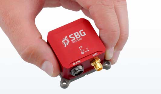
SBG’s Ellipse series is also eligible through its education program. The series is composed of SBG’s miniature inertial measurement units, attitude and heading reference systems and inertial navigation systems. In addition, the entire product line has been renewed. The new Ellipse INS/GNSS embeds a quad constellation, dual frequency, and dual Antenna RTK GNSS receiver to bring centimetric position and higher accuracy orientation in the smallest package, SBG added.
In addition to being compatible with CAN and ROS, the Ellipse Series’ sensors are compatible with SBG’s Qinertia Post-Processing Software, the SBG Systems’ in-house INS/GNSS post-processing software. Qinertia allows users to replay, analyze, improve their trajectories and access RTK corrections worldwide to bring their project to the centimetric accuracy.
SBG Systems designs and manufactures MEMS-based inertial motion sensing solutions. According to SBG, its products are ideal solutions for industrial and research projects such as unmanned vehicle control, antenna tracking, camera stabilization and surveying applications.
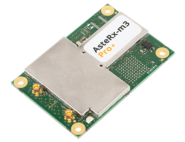
The new AsteRx-m3 family features state-of-the-art GPS/GNSS OEM boards optimized for power consumption and ease of integration.
Photo: Septentrio
Septentrio has expanded its GPS/GNSS OEM portfolio with the AsteRx-m3 product family. AsteRx-m3 receivers target various use cases and offer flexibility and affordability with no compromises of performance.
The AsteRx-m3 family features very low power consumption, allowing longer operation times. Its easy-to-integrate design enables short set-up times and faster time-to-market.
“With the AsteRx-m3 product family, Septentrio redefines state-of-the-art GNSS positioning performance,” said Danilo Sabbatini, product manager at Septentrio. “It was a challenge to design a product that delivers multi-frequency and multi-constellation positioning, combined with Septentrio’s renowned GNSS+ technology while optimizing power. The AsteRx-m3 product not only excels in this but does so at a reduced cost.”
All AsteRx-m3 products represent the next generation of technology in the GNSS OEM market, delivering centimeter-level accuracy, availability and reliability in a credit-card sized board, Septentrio said.
The new product family includes three types of GNSS OEM boards.
The AsteRx-m3 Pro rover receiver tracks signals from all available GNSS constellations on three frequencies. Simple and powerful, it operates both in single- and dual-antenna modes.
The AsteRx-m3 ProBase is designed to operate as a reference station for RTK and PPP-RTK networks. It can be used as a base station or for network densification.
The AsteRx-m3 Pro+, a full-feature OEM receiver board flexible enough to fit into any application and to be used either as a rover or a base station in a single- or dual-antenna mode.
By offering its next-generation GNSS technology in a diversity of products Septentrio aims to improve customer experience while optimizing prices.
The number of GNSS constellations, satellites and signals is constantly growing. The threats to GNSS — from unintentional radio frequency interference (RFI), jamming, spoofing, multipath… and Federal Communications Commission rulings — are increasing, as are the public’s expectations of GNSS accuracy.
All these factors contribute to the need for ever more powerful and advanced simulators that can realistically simulate a wide range of optimal and suboptimal environments. That is why simulators are a rapidly growing sector of the GNSS industry.
At present, the main defense against jamming are continuous radiation pattern antennas (CRPA). Therefore, it is essential that simulators be able to accurately reproduce signals from CRPAs. They are even more useful when they can generate M-code (MNSA) signals, which not all simulators do.
Additionally, the development of autonomous vehicles requires engineers to simulate driving millions of miles, under a variety of environmental and traffic circumstances. To accomplish this in a reasonable amount of time requires them to run simulations faster than in real time, or run many simulations in parallel.
Finally, there is an increasing need to simulate alternative positioning, navigation and timing (PNT) signals being developed as supplements to and substitutes for GNSS signals in circumstances that make the latter unavailable or unreliable.
These are some of the challenges facing manufacturers of GNSS simulators. What follows are their brief descriptions of the approaches they are taking and the innovations they are introducing.
What is your most recent innovation?
Our latest simulator innovations contain wave-front generation signal technology, which allows you to generate GNSS and interference signals that represent the received signals for each antenna element in a phased array antenna manifold, usually referred to as a controlled radiation pattern antenna (CRPA). Our modular design approach enables users to simulate IMU data commensurate with the wave-front signals for a complete coherent GNSS/IMU simulation that is ideal for stimulating receivers that contain CRPA and IMU capabilities. Our simulators also contain proprietary synchronization technology that allows users to synchronize multiple systems to produce a “wave-front” of GNSS and IMU signals for multiple vehicles, or even an entire fleet.
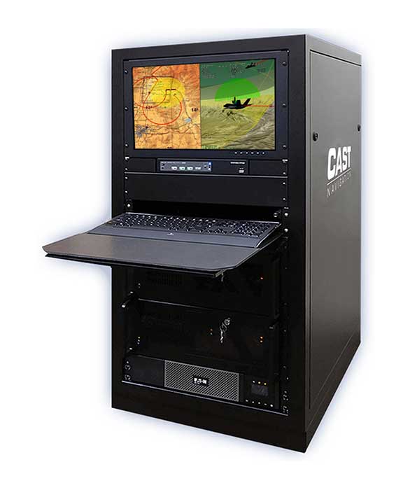
Photo: CAST Navigation
What is your approach to jamming and spoofing?
CAST Navigations’ family of GNSS simulators are capable of realistically simulating a wide range of suboptimal conditions—such as jamming/spoofing, multipath, RF interference and satellite constellation perturbations—for virtually any commercial or military environment. Our interference signals or “jammers” can be located at any terrestrial location and can be static or dynamic in nature. A distinguishing feature of CAST Navigations’ simulation systems is that our interference signals are phase-controlled and coherent, allowing for proper phase transmission of each signal type for each receiving antenna element. You can also add an INS capability to any of our systems. These types of systems are perfect for testing GNSS and GNSS/INS types of navigation equipment.
What’s coming by 2023?
One of the key trends is the ability to generate M-code (MNSA) signals. Jamming and spoofing are becoming more prevalent, not just to the military but also to consumers. Every day, the military, as well as people like you and me, are starting to encounter more instances of interference that can deny GNSS equipment and even phones the ability to track some GNSS satellites or that transmit incorrect GNSS data, causing receivers to display incorrect position solutions. So, our focus is on products and capabilities that enable our customers to simulate those types of environments and help them to mitigate those kinds of events.
Orolia
Lisa Perdue Product Manager
What is your most recent innovation?
At Orolia we continue to evolve our innovative software-defined simulator approach. Our most recent innovation is our advanced spoofing option. We have taken our ability to define multiple jamming transmitters, each with their own trajectory and antenna pattern, and added the ability for the transmitters to send spoofing signals as well. By utilizing our capability to run multiple simulations on a single system, we give the user the ability to control every parameter of the generated spoofing constellation(s). The system automatically calculates the signal time of flight and the propagation loss, making this advanced capability powerful and easy to use.
What is your approach to jamming and spoofing?
Simulation of threat environments is a critical component of GNSS receiver testing. As awareness of the impact that jamming and spoofing can have on a GNSS-based system rises, so does the need to test. That is why we have implemented advanced jamming and spoofing options into our Skydel simulator’s core engine. Replication of degraded environments with threats ranging from one to hundreds is possible using the same hardware and software used for generating GNSS signals. No third-party hardware or software is required for complete testing against jamming and spoofing because we feel that this capability should be part of the core system, not an afterthought.
Photo: Orolia
What’s coming by 2023?
In the coming years, we expect to see more requirements for simulation of alternative positioning, navigation, and timing (PNT) signals. As governments and organizations continue to investigate alternate technologies, it will become necessary to simulate low Earth orbit (LEO) PNT, ground-based transmitters, and other signals being considered.
Another growing trend is the adoption of controlled reception pattern antennas (CRPAs) for their anti-jam capabilities. These anti-jam antenna systems can only be tested by specialized simulation systems, so we can imagine these simulation systems being commercialized for a broader market around 2023.
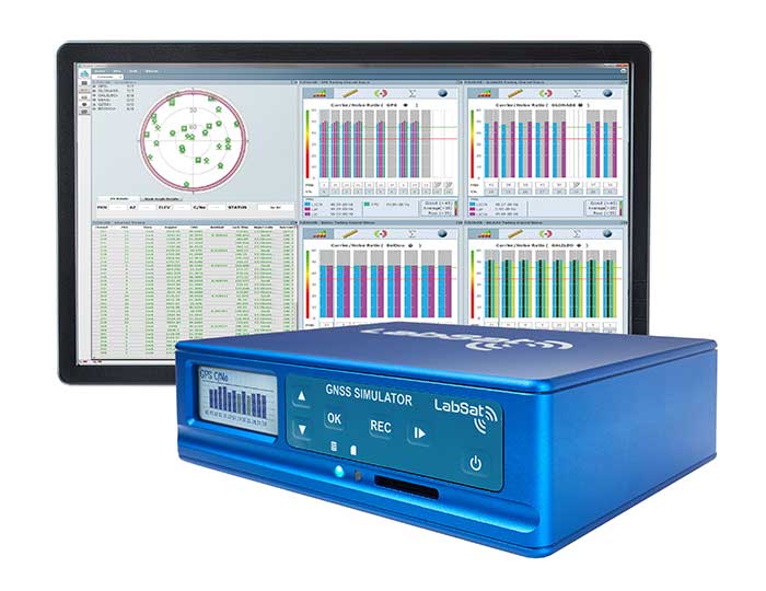
Racelogic
Julian Thomas Managing Director
What is your most recent innovation?
Recognizing the need of our customers to test their products with a simple solution that uses the latest GNSS signals, we have updated our SatGen software to create accurate simulations using all satellite data currently being transmitted across the various constellations. We have also optimized the performance of SatGen so that a standard desktop PC can be used to simulate these signals in real time. Also, the simulation can now be driven using an external NMEA stream, allowing full remote control of the trajectory.
What is your approach to jamming and spoofing?
The LabSat 3 Wideband records and replays all available GNSS signals in high fidelity, allowing jamming and spoofing signals to be reproduced accurately on the test bench.
Photo: Racelogic
What’s coming by 2023?
With so many employees now working from home due to COVID-19, the pressing concern for many companies developing GNSS technology is how to provide employees with suitable equipment that is required for them to carry out their jobs efficiently away from the office. Usually these employees would utilize the shared resources of a well-equipped office, with experts on hand to help, but working from home has made access to these devices challenging. Due to LabSat 3’s small size, low cost and ease of use, we have seen a significant increase in sales to companies furnishing their employees with a suitable method of testing their GNSS devices while working from home.
With the advent of a new breed of high-performance, low-cost GNSS receiver, many new applications are being developed in new and exciting sectors, utilizing a level of accuracy previously considered too expensive to be a commercial proposition. The number of GNSS engines will therefore increase rapidly in the marketplace, with a corresponding increase in demand for cost-effective signal simulation for test and development.
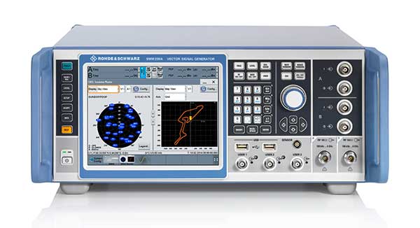
Rohde & Schwarz
Markus Irsigler Product Manager Signal Generators, Power Meters
What is your most recent innovation?
We further improved multi-frequency, multi-constellation simulation capabilities in our high-end segment. The GNSS high-end simulator R&S SMW200A provides signals for all GNSS frequency bands on a single RF output. A second internal RF path can be used for advanced interferer simulation, testing the receiver’s resilience to spoofing or to address dual-antenna scenarios. This keeps setups simple and compact. When more than two RF paths are required, two or more R&S SMW200A can be operated together in a master/slave configuration. Such setups are required for multi-antenna receiver test applications where the signals’ relative carrier phases are analyzed, like CRPA or attitude determination tests. Our new RF ports alignment software automates alignment of the GNSS signals and guarantees correct amplitude, time and phase relations at the RF inputs of the device under test. We also increased the maximum channel count to more than 600 channels to improve testing of multi-constellation, multi-frequency receivers against multipath, jamming and spoofing.
What is your approach to jamming and spoofing?
Besides our recent innovations, Rohde & Schwarz plans to provide new interference simulation capabilities within the GNSS simulator. This new feature will allow the user to replay recorded jammer signals as well as user-defined waveforms. The R&S Pulse Sequencer software helps with the definition of most complex interferer scenarios.
Photo: Rohde & Schwarz
What’s coming by 2023?
Developments in the field of advanced driver-assistance systems (ADAS) aiming for fully autonomous vehicles raise new challenges for reliable PNT solutions. Simulation of interference and jamming scenarios will hence become important in the automotive market. Antenna arrays have proven suitable to counteract RF interference (RFI) by incorporating spatial-processing techniques and might therefore find greater entry into the automotive market. Test solutions must address requirements for simulating all kinds of intentional and unintentional RFI for multi-constellation, multi-frequency and multi-antenna receivers. Apart from simulating GNSS and interference sources, test solutions for autonomous driving will require several other techniques and signals to be applied or simulated, such as RTK/PPP or outputs from other vehicle sensors to perform sensor fusion.
Spirent Federal Systems
Jeff Martin Vice President, Sales
What is your most recent innovation?
Launched in 2018, SimMNSA became the first MNSA simulator to achieve GPS Directorate security approval. The software enables users to simulate true MNSA M-code with real-time code and message generation, removing the constraints imposed by simulator data sets (SDS). SimMNSA v2.0 does even more. It is able to broadcast nominal M-code conditions and recreate SDS-defined events. It incorporates an advanced editor to edit military navigation (MNAV) content, allows users to craft and define scenarios, and much more.
What is your approach to jamming and spoofing?
Spirent offers numerous capabilities for emulating GNSS signals in the presence of interference and spoofing attacks. Our solutions provide accurate, repeatable and quantifiable signals, enabling customers to conduct accurate tests with trusted results. We can test against internally generated interference enabling multiple “fields” of jammers with various interference types; hundreds of interference signals using external IQ blended with simulator-generated GNSS, and Blue Force Electronic Attack jamming waveforms for testing MGUE devices operating in GPS-denied environments. Spoofing capabilities include signal, navigation data and cyber-level attacks via manipulation of up to 12 copies of each primary GNSS constellation, each fully editable; intuitive spoof attack generation via Spirent’s SimSAFE software option — which also allows live sky synchronization/spoofing, and more.
Photo: Spirent
What’s coming by 2023?
Threats to reliable and accurate GNSS navigation and timing are developing rapidly. Fortunately, innovative solutions for resilient PNT are in development and will continue to challenge the industry for years to come. The ability to simulate these threats and the mitigation techniques to overcome them is changing the landscape for the simulator industry. It’s more important than ever to have up-to-date test tools. Robust signals along with frequency and constellation diversity will continue to drive the market in addition to GNSS backup systems, or AltNav. The FCC has certainly presented the GNSS industry with an immense challenge.
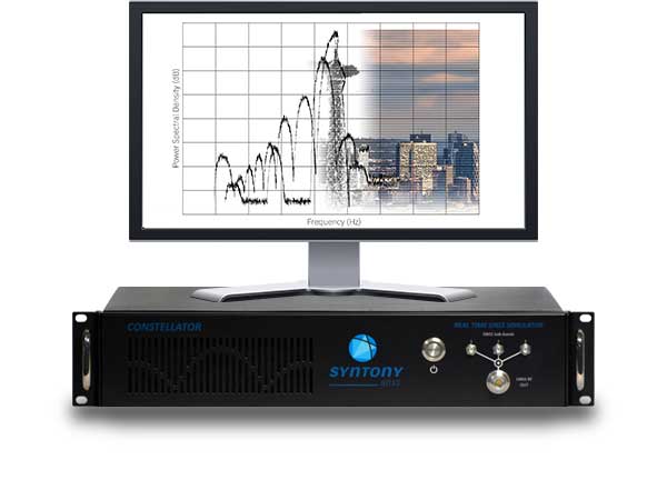
Syntony GNSS
Sylvain Daubas Simulator Activity Manager
What is your most recent innovation?
Yesterday, GPS systems had to “work.” Today, they must work fine. This is the difference, and all equipment vendors have realized this. It is no longer acceptable to have 200 meters or more of error in an urban environment. Because of the extreme complexity of the electromagnetic situation in the GNSS spectrum, making a reliable and precise location system requires more and more powerful and advanced simulators. This is why the GNSS simulator market is booming.
Among the many new features implemented in Syntony’s GNSS simulator this year, two stand out.
First, 1000-Hz hardware-in-the-loop now allows an accurate simulation for high-dynamic receivers (up to more than 100 Gs!), with zero artifact and zero-effective latency. This is the ultimate in trajectory management.
Second, signal computing capacity has made a significant leap forward due to hardware and software optimizations. Constellator can now simultaneously generate up to 660 L1 C/A-equivalent signals. And this level of performance can be unlocked remotely, without a hardware update.
Photo: Syntony GNSS
What is your approach to jamming and spoofing?
Simulating a GNSS environment with a set of jamming or spoofing signal sources today is the standard. But what about a simulation of an extremely complex urban scene with 50 or 100 jamming/spoofing sources? The only reasonable solution to implement this would be a massive parallel software-defined radio (SDR)-based simulator solution. This is what Syntony can and will do, thanks to its full software GNSS simulator architecture, which can be distributed on a server farm.
What’s coming by 2023?
A revolution is arriving: the possibility of generating a full GNSS simulation including many hundreds of satellites and signals, in real time and in pure software. This is now possible, and Syntony has demonstrated it with the Constellator. This will change the simulation world. First of all, Moore’s law will bring significant improvements to this domain year after year. More importantly, new systems and services will be possible: massive parallel scenario simulation including jamming and spoofing, floating simulator licenses, software as a service, etc. In this trend, playback machines will be needed, and obviously a strong internet connection will be necessary to download hundreds of gigabytes of I/Q files overnight.
Feature image: Samuel King Jr./United States Air Force
Walmart is teaming up with drone delivery company Zipline to launch a drone delivery operation in the United States. According to Walmart, this first-of-its-kind drone delivery service will make on-demand deliveries of select health and wellness products with the potential to expand to general merchandise.
Trial deliveries will take place near Walmart’s headquarters in Northwest Arkansas. The trials will use Zipline’s proprietary technology.
Zipline will operate from a Walmart store and can service a 50-mile radius, Walmart said. The company’s launch-and-release system allows for quick on-demand deliveries in under an hour, and it also eliminates carbon emissions, Walmart added.
Zipline began operating in 2016 in Rwanda, primarily focusing on the on-demand delivery of medical supplies. According to Zipline, it has safely delivered more than 200,000 critical medical products to thousands of health facilities serving more than 20 million people across multiple countries.
The operation will likely begin in early 2021, Walmart said.
YIC is a manufacturing and design company for quartz crystals, crystal oscillators, GPS/GNSS modules, GPS/GNSS receivers and RF antennas. It provides low-power solutions to solve product problems that require frequent charging.
YIC’s new product — the Ultra Low Power GPS/GNSS Module (Model YIC71009EBGG and YIC71513PGMGG) — is designed as an IoT product solution, targeted to improve the operating times of IoT applications such as trackers, wearables and portable devices.
According to its press release, YIC “is dedicated to providing the best solution for GPS devices and sees a tremendous opportunity in the GNSS market to solve power consumption problems.” The recent industry trend of multi-frequency GPS, low-power consumption, and dead reckoning will be advantageous to YIC in terms of high-grade products entering the global market.
Models YIC71009EBGG and YIC71513PGMGG provide:
Ultra-low power consumption – 6mA (Typical).
Multi-constellation – GPS/QZSS + GLONASS.
Small size
About YIC
Founded in 1994 and headquartered in New Taipei City, Taiwan, YIC is a professional partner in frequency control, GPS/GNSS modules, receivers and RF antennas, advanced low power GPS, and small size solutions.
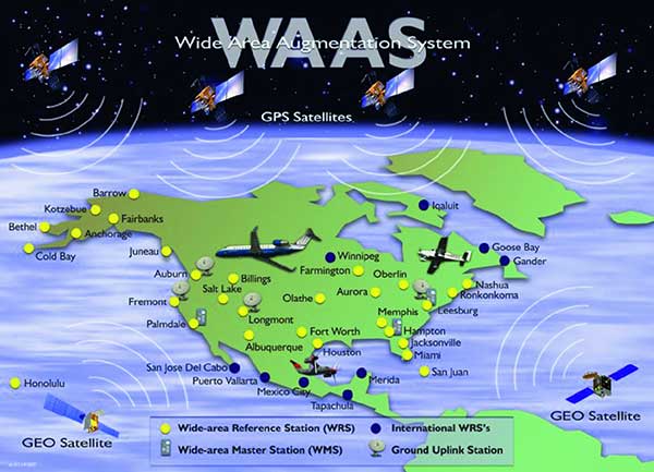
Thirty years ago, NAVSYS was deep into the development of the Wide Area Augmentation System (WAAS). I had the honor of being the chair of the RTCA SC-159 Integrity Working Group, which developed the first concepts for what evolved into three integrity standards for GPS: multi-sensor integration, receiver autonomous integrity monitoring (RAIM) and wide-area differential GPS using a GPS integrity channel (GIC) to broadcast corrections over a geostationary overlay.
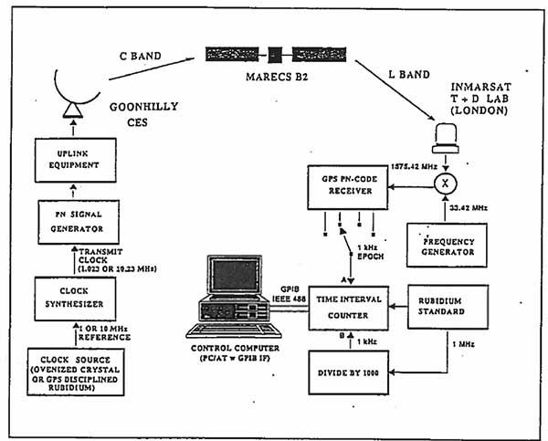
NAVSYS, working with Inmarsat Corporation, built the first prototype WAAS SIGGEN equipment, which was deployed at the Coonhilly Coast Earth Station and used to transmit an L-band C/A-code signal over the Inmarsat Atlantic Ocean Region MARECS-B satellite to a software GPS receiver that we had developed and installed at Inmarsat’s Test and Development Laboratory in London.
First Inmarsat Geostationary Overlay Test-Bed, 1991. (Image: NAVSYS)Image: FAA
This evolved into the FAA’s WAAS program, which used the NAVSYS SIGGEN for the initial deployment, test and evaluation. The algorithms developed by NAVSYS were ultimately licensed to Raytheon for use on the operational WAAS and MSAS systems.
Earth-imaging and scientific payloads have arrived in French Guiana, both designed for Ariancespace’s Vega mission in November.
The spacecraft were delivered by a chartered Antonov AN-124 cargo jetliner that touched down at Cayenne’s Félix Eboué Airport. They were then transported by road to the Spaceport, where processing is now underway in separate clean room areas of the S5 payload processing facility.
According to Arianspace, the Vega’s mission with these satellites is designated Flight VV17 in Arianespace’s launcher family numbering system.
The two satellites include SEOSAT-Ingenio, Spain’s optical observation satellite, and Taranis.
SEOSAT-Ingenio
Arianespace’s launch services contract for the SEOSAT-Ingenio satellite was signed with the European Space Agency for Spain’s Center for Development of Industrial Technology (CDTI). The satellite features optical technology, developed primarily by the Spanish space industry with Airbus in Spain as the prime contractor. Its liftoff mass will be approximately 840 kg.
High-resolution imagery from SEOSAT-Ingenio is to be used for civil and military purposes in such applications as security, land management, natural resources, border surveillance, agriculture and natural disaster crisis management, Arianspace said. The satellite is owned by the Spanish Ministry of Science and Technology, with the CDTI leading the spacecraft project by delegation and also assuming its cost.
Spain’s SEOSAT-Ingenio (left) is readied for the startup of its checkout process in the Spaceport’s S5 payload preparation facility, which will begin after the external wrapping is removed. The French Taranis scientific satellite (right) undergoes an initial inspection in another of the S5 clean room areas. (Photos: Arianspace)
Taranis
Taranis, or Tool for the Analysis of RAdiation from lightNIng and Sprites, is named after the god of thunder in Celtic mythology. It will study impulsive transfers of energy between the Earth’s atmosphere and the space environment that occur above thunderstorms.
Funded by the French CNES space agency, this satellite will have a liftoff mass in the 200-kg. category and is to provide data on the transient luminous events that have been observed in the past 30 years, particularly such phenomena that are called sprites, jets and elves.
According to Arianspace, both SEOSAT-Ingenio and Taranis will operate in similar orbits at an altitude of approximately 700 km. In ride-sharing this launch on Arianespace’s light-lift Vega launcher, the two spacecraft will be deployed by a VESPA payload dispenser, produced by Airbus in Spain for Avio.
A link to the live event will be sent to you two hours before the event. Your personalized event URL will be automatically generated by the ON24 system. To ensure receipt of the email, please whitelist this email address by adding it to your contacts: [email protected].
This presentation will begin at 1 p.m. Eastern / 10 a.m. Pacific on Thursday, October 22. A recording will also be sent to you the following day so you can watch it on-demand.
Audience members may arrive 15 minutes prior to live time. If you have any questions, please contact event producer Kelly Limpert at [email protected]
Orolia Defense & Security has been granted security approval by SMC Production Corps. for BroadSim MNSA (modernized Navstar security algorithm).
The company delivered its first batch of MNSA M-Code to multiple customers in late August. BroadSim MNSA joins P(Y)-Code and AES M-Code as another GPS encrypted signal that Orolia Defense & Security supports, the company said.
Thought, skill, and patience went into developing this solution,” said Tyler Hohman, director of products at Orolia. “Not only have we taken an innovative approach to ensuring the security of this technology, our implementation was designed with ease of use being top-of-mind — from procurement, to delivery, to installation, to testing — so our customers can spend more time supporting their mission and less time making their simulator work.”
According to Orolia, BroadSim is a proven and trusted solution among government, Department of Defense and military customers with more than 100 systems fielded. BroadSim was recently selected by the U.S. military to support diverse testing of military GPS receivers, the company added.
BroadSim MNSA users receive a step-by-step guide allowing them to effortlessly set-up and generate MNSA in minutes and quickly downgrade the system on a moment’s notice, Orolia said.
The capability is currently available as a software upgrade to current BroadSim users or as a purchase alongside Orolia’s BroadSim hardware platform.
Orolia Defense & Security, which operates as a proxy-regulated company and wholly-owned subsidiary of Orolia, provides resilient PNT solutions to U.S. government agencies, defense organizations and their contractors.
Several agriculture groups have been added to the Keep GPS Working Coalition, which was launched in June to protect GPS users from harmful interference resulting from the Federal Communications Commission’s (FCC) decision to permit Ligado Networks to operate a terrestrial wireless network in the band adjacent to GPS.
The new members from the agriculture sector join the Association of Equipment Manufacturers, American Farm Bureau Federation, American Road & Transportation Builders Association, Aircraft Owners & Pilots Association and Boat Owners Association of The United States in urging the reversal of the FCC’s Ligado order.
“The FCC’s decision represents a sweeping governmental and regulatory assault on farmers who are already facing unprecedented challenges including severe weather, low commodity prices and supply chain vulnerability as a result of COVID-19,” said Dale Leibach, spokesperson for the Keep GPS Working Coalition. “The order must be stopped. The FCC’s decision must be reversed.”
According to the coalition, farmers are increasingly relying on precision agriculture applications that deliver centimeter-level accuracy that enables farmers to maximize crop yields while lowering costs and environmental impact. Precision farming also reduces costs for consumers, delivers economic benefits for rural economies and enables the efficient production of the foods required to meet a growing global demand for food, fiber and fuel, the coalition added.
“Ag retailers often fill a role as trusted advisor to their farmer customers, suggesting new and emergent technologies in the precision ag space,” said Daren Coppock, president and CEO of the Agricultural Retailers Association. “Without the GPS location services needed for proper planning and implementation of these resources, farmers may not have the tools they need to increase crop yields, lower input loads and decrease inefficacies. ARA stands behind the coalition’s work to protect GPS as a valuable resource to farmers.”
Agriculture industry leaders and a member of the House Committee on Agriculture will participate in a conversation discussing how the FCC’s decision to allow Ligado Networks to operate a terrestrial wireless network will threaten the reliability of GPS receivers used in precision agriculture at 11 a.m. EDT on Oct. 1. Details can be found here.
The United Kingdom will explore new options for satellite navigation and timing capability to support critical infrastructure, it announced in a press release.
The Space-Based Positioning Navigation and Timing Programme (SBPP) will explore new and alternative ways to deliver vital satellite navigation services to the U.K. for transport systems, energy networks, mobile communications, and national security and defense.
The SBPP also aims to boost the British space industry and develop the U.K.’s own capabilities in these services.
UK GNSS program reinvented
The new program follows the work of the UK GNSS program, which concludes Sept. 30. UK GNSS began in 2018 as a result of Brexit and the U.K.’s departure from the Galileo program.
UK GNSS is an exploration programme that has developed outline plans for a conventional satellite system as an alternative to American GPS or the EU’s Galileo. The program will now be reset as the SBPP to build on this work to consider newer, more innovative ideas of delivering global satnav and secure satellite services to meet public, government and industry needs.
In 2018, the government announced an 18-month program, led by the UK Space Agency, to develop a conventional GNSS, which could meet U.K. security requirements and support the U.K.’s sovereign space and cryptography sectors.
Work completed by the UK GNSS Programme so far has developed cutting-edge British expertise in areas such as spacecraft and antenna design, satellite and ground control systems, systems engineering and simulation, which have wider applications across the space sector, in addition to supporting specialist U.K. jobs and industrial GNSS capability.
The refocused SBPP program could include technology that supports people’s everyday lives, such as emergency services to locate incidents, financial services companies to regulate exchanges on the U.K. stock market, or energy networks to ensure households receive power. Satellite navigation systems are also necessary to unlocking future technologies such as driverless cars, smart cities and artificial intelligence.
Capitalizing on the ingenuity of British businesses and academics, the program will explore the use of different kinds of satellites at various levels of orbit by exploiting technologies offered by companies at the cutting-edge of innovation such as OneWeb, Inmarsat and Airbus.
A Cabinet Office Study examining the need for a U.K. space-based system for secure positioning, navigation and timing concluded that any solution would need to examine more options and further work is needed to determine what form a potential system takes so it provides value for money.
To meet U.K. industry and government needs for resilient global navigation and timing while also providing value for money to the public, the new SBPP will consider collaboration with international allies to share satellite navigation services, costs and technology.
“Satellites underpin so many of the services that we all use every single day, from precise train timetables on our phones and satnavs in our cars,” said Business Secretary Alok Sharma. “Through our Space-Based Positioning Navigation and Timing Programme, we will draw on the strengths of the U.K.’s already thriving space industry to understand our requirements for a robust and secure satellite navigation system. This includes considering low-orbiting satellites that could deliver considerable benefits to people and businesses right across the U.K., while potentially reducing our dependency on foreign satellite systems.”
“I am delighted to see a further boost to the U.K.’s already thriving space industry,” said Scotland Office Minister Iain Stewart. “The U.K. government works closely with industry and academia to support the sector. We have high ambitions for the U.K. to be a global sector leader. The U.K. government is expanding its plans to understand requirements for a satellite navigation system. Satellite navigation provides the core services that we all use every day such as our mobile networks and is the key to unlocking further technical innovation in the future. This new programme will potentially pave the way for greater independence from foreign systems such as the United States’ GPS or the EU’s Galileo system which will allow greater opportunities for British businesses.”
“Our work to date has developed cutting-edge U.K. expertise in satellite navigation spacecraft, antenna design and control systems, while supporting high-skilled jobs,” Graham Turnock, CEO of the UK Space Agency said. “Now is the time to drive this work further to look into wider, more innovative ways of delivering this important national capability — to help protect our critical infrastructure and put the U.K. at the forefront of the development of new space technologies.”
Currently, the U.K. is entirely dependent on foreign systems for these critical navigation services. SBPP will enable to the U.K. to build on its thriving space industry, home to global players such as Inmarsat, Airbus, Surrey Satellites (SSTL) and others, to become a global leader in space navigation technologies, developing new opportunities for businesses in the U.K. and overseas and creating new highly skilled jobs.
The government has made clear its ambitions for the U.K. to become a globally competitive space power and is taking action through the newly established National Space Council, emerging National Space Strategy and the Integrated Review of Security, Defence, Development and Foreign Policy, to create the conditions for a strong, secure and innovative space sector that delivers for the British people.
A government-backed study from London Economics estimated that sustained disruption to existing satellite navigation capabilities would likely cost the U.K. economy £1 billion per day. Investment in space technology and services will enable the U.K. to build back better, unleashing the country’s global competitiveness and underpinning growth and high-skilled jobs.
The U.S. Federal Aviation Administration (FAA) has made it easier for drone pilots to quickly and safely access controlled airspace by adding 133 air traffic facilities to the Low Altitude Authorization and Notification Capability (LAANC) system. The expansion is based on feedback from the drone community.
LAANC is an automated application and approval system for drone pilots requesting to fly below 400 feet in controlled airspace.
As the FAA continues to modernize the national airspace to accommodate more users, the agency made LAANC accessible for 726 airports and 537 facilities, covering 81% of eligible airspace.
LAANC is a collaboration between the FAA and the unmanned aircraft systems (UAS) industry which directly supports the safe integration of drones into the nation’s airspace. The service is accessible to all pilots who operate under the FAA’s small drone rule.