ARPAS-UK — the Association of Remotely Piloted Aircraft Systems UK — is requesting the nation’s drone operators to let them know whether they could help fight the battle against coronavirus.
“We are aware there are thousands of Commercial Drone Operators out there; we may need your help,” ARPAS-UK said in a statement to the drone industry.
ARPAS-UK said it is “working hard to push the capabilities of the drone industry and making sure that government departments are reminded of the expertise and capabilities of the drone community in the UK.”
ARPAS-UK is especially targeting relief for emergency services, as well as delivery of emergency food and medicine to vulnerable people, spraying of disinfectant, and collection of imagery and video to help monitor various situations.
Current activities that could be expanded include vital inspections necessary to keep infrastructure running or maintain safety, such as monitoring following floods or environmental activity, and monitoring gas levels on sites.
ARPAS-UK is creating a secure database of the information that will be destroyed when no longer required. To fill out a form for the database, visit this page.
“Seen & Heard” is a monthly feature of GPS World magazine, traveling the world to capture interesting and unusual news stories involving the GNSS/PNT industry. This month, we focus on UAVs.
Screenshot: Quaternium video
Non-stop flight in Valencia
On Feb. 3, drone company Quaternium broke its own record for long flight time with a hybrid-fuel electric drone. The Quaternium HYBRiX UAV took off at 08:52 a.m. in Valencia, Spain, and landed at 17:02 p.m., after performing a stationary flight of 8 hours and 10 minutes. The new endurance record for non-stop flight time was accomplished with an experimental version of the company’s HYBRiX 2.1 drone, which carries 25 kilograms of maximum take-off weight.
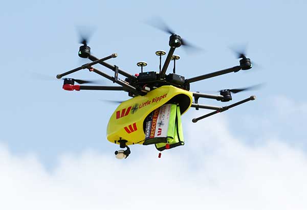
Westpac Little Ripper. (Photo: The Ripper Group/SLSA)
Dye-dropping drones
A company is providing drones that can drop sea- marker dye into ocean surf, allowing lifeguards on shore to spot riptides. The drones have been developed by The Ripper Group, reports the Brisbane Times. A fleet of 51 drones is being deployed across 25 beaches on the Gold and Sunshine coasts in Australia, as well as farther north. The drones also could be used to rapidly assess situations such as people swimming or climbing on rocks. Plus, the company has deployed drones to detect sharks and crocodiles.
Agricultural diseases cause significant crop losses worldwide. One widespread disease is yellow Sigatoka, which limits banana cultivation. Scientists at Brazil’s Federal University of Ceara have used high-resolution aerial images from an Inspire 1 UAV and machine learning to monitor yellow Sigatoka in banana crops, identifying and classifying disease symptoms such as leaf spots. The system also provides humidity and temperature data that can help assess and manage the disease.
Rescue from above
A blind man who spent 33 hours lost in February in the freezing Connecticut woods was rescued thanks to a police drone. Richard Doty, 62, was trapped in the woods near his Enfield home after he became disoriented, Enfield police said on Facebook. Temperatures had dipped as low as 9° F. Officers borrowed a drone and a skilled pilot from police in neighboring Vernon. Within 30 minutes of lift-off, the drone spotted Doty about 100 yards into the woods, hidden from view down an embankment.
The virtual, student-driven hackathon challenges teams to develop innovative solutions to the problems posed by the COVID-19 pandemic. Over the course of the event, teams will work on urgent problems and challenges that have been identified and validated by subject matter experts, said CBID. Solutions to these problems have the potential for timely impact in the fight against COVID-19.
In addition, each team will have access to lectures and Q&A sessions with experts on the disease, as well as the design process.
Esri is providing developer licenses and software guidance to participants, the company said. An Esri expert also will serve as a judge for the competition.
Teams presenting the best ideas will be invited to work with CBID to secure resources and contacts to further develop their concepts. Monetary prizes may be awarded based on funding, but the spirit of the competition is to contribute to the global war against COVID-19, CBID added.
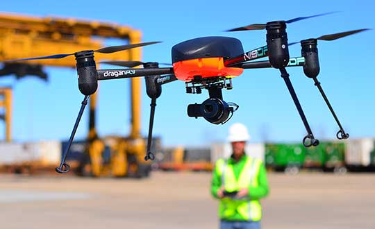
Draganfly will integrate a breakthrough health diagnosis onto cameras and UAVs to combat coronavirus.
In a rush to combat the global spread of the deadly coronavirus (COVID-19) in the U.S., Draganfly will deploy “pandemic drones” to remotely monitor and detect people with infectious and respiratory conditions to help stop the spread of the disease.
The Draganfly drones will be fitted with a specialized sensor and computer vision system that can monitor temperature, heart and respiratory rates, as well as detect people sneezing and coughing in crowds and other places where groups of people may work or congregate.
Draganfly will serve as the global systems integrator for the Vital Intelligence Project, a health and respiratory monitoring platform from Vital Intelligence Inc. The breakthrough technology was developed in a collaboration between the University of South Australia and the Science and Technology Group (DST), which is part of Australia’s Defence Department.
Coughing detected
The sensing system uses existing and new camera networks, UAVs and remotely piloted aircraft systems for health monitoring and detection of infectious and respiratory conditions — including monitoring temperatures, heart rates and respiratory rates.
The drones can monitor people in public crowds, workforces, airlines, cruise ships, convention centers, border crossings or critical infrastructure facilities. The technology can also be used to monitor potential at-risk groups, such as seniors in care facilities.
The Draganfly demonstration video below shows the camera detecting not only temperature, heart rate and respiration, but when a person is coughing.
Draganfly Video
Under the exclusive contract, initially budgeted at $1.5 million, Draganfly will use its engineering, integration and distribution expertise as well as its secure supply chain for immediate commercialization and deployment of the technology.
“The university and Defence supported my team’s efforts to develop automation for use in epidemics and disasters,” said Javaan Chahl, Defence Science and Technology Chair at the University of South Australia. “We had imagined the technology being used in a future relief expedition to some far-away place. Now, shockingly, we see a need for its use in our everyday lives immediately. Draganfly’s industrial know-how is quickly helping us ensure our research can save lives.”
The Draganflyer Commander UAV is a remotely operated miniature helicopter designed to carry wireless camera systems. (Photo: Draganfly)
“Draganfly has been selected because of its proven leadership in an industry so important to public safety at such a critical time. We look forward to working with global agencies and industry to rapidly deploy this important technology,” said Cameron Chell, Draganfly CEO.
“Draganfly is honored to work on such an important project given the current pandemic facing the world with COVID-19,” said Andy Card, Draganfly director and former U.S. Secretary of Transportation and White House chief of staff. “Health and respiratory monitoring will be vital for not only detection, but also utilizing the data to understand health trends. As we move forward, drones and autonomous technology doing detection will be an important part of ensuring public safety.”
“With fighting epidemics rising as a global priority, new versatile technologies, such as humanitarian mission UAVs, are immediately needed to detect and track outbreaks so that critical interventions can be deployed sooner and with greater effectiveness,” said Jack Chow, advisor to the Vital Intelligence Project. Chow is a former first assistant director-general on infectious diseases for the World Health Organization (WHO).
Smart speakers such as the Amazon Alexa or Google Home haven’t mastered determining user location in the home. Solving this problem was the focus of a University of Illinois at Urbana-Champaign research team’s recently published paper.
The team — led by Coordinated Science Lab graduate student Sheng Shen — explores the development of VoLoc, a system that uses the microphone array on Alexa as well as room echoes of the human voice to infer user location inside the home.
If applied, after receiving commands such as “turn on the light” or “increase the temperature,” Alexa would know which light and room is intended. Using a technique known as reverse triangulation, Shen and advisor Romit Roy Choudhury are getting closer to voice localization.
“Applying this technique to smart speakers entails quite a few challenges,” Shen said. “First, we must separate the direct human voice and each of the room echoes from the microphone recording. Then, we must accurately compute the direction for each of these echoes. Both challenges are difficult because the microphones simply record a mixture of all the sounds altogether.”
VoLoc addresses these obstacles through an align-and-cancel algorithm that iteratively isolates the direction of each arriving voice signal, and from them, reverse triangulates the user’s location. Some aspects of the room’s geometry is spontaneously learned, which helps with the triangulation.
While this is an important breakthrough, Shen and Roy Choudhury plan to expand the research to more applications. “Our immediate next step is to build to the smart speaker’s frame of reference,” Shen said. “This could mean superimposing the locations, as provided by VoLoc, on a floorplan to determine that the user is in the laundry room. Alternatively, if the smart speaker picks up the sounds made by the washer and dryer in the same location as the voice command, it can come to the same conclusion.”
Citation. S. Shen, R. Choudhury et al., “Voice Localization Using Nearby Wall Reflections,” to be presented at MobiCom 2020: 26th Annual International Conference on Mobile Computing and Networking, Sept. 21–25, London, UK.
Photo: Michael Wapp/iStock Editorial / Getty Images Plus/Getty Images
The research and demonstration projects addressed topics such as drone operations; critical communications; surveillance and tracking; information management; aircraft systems; ground-based technologies; cyber-resilience; and geo-fencing.
“Drones are disrupting business as usual in air traffic management,” said Florian Guillermet, executive director, SESAR Joint Undertaking. “A simple adaptation of our current air traffic management system is not enough; accommodating these air vehicles in the numbers forecast requires a new approach.”
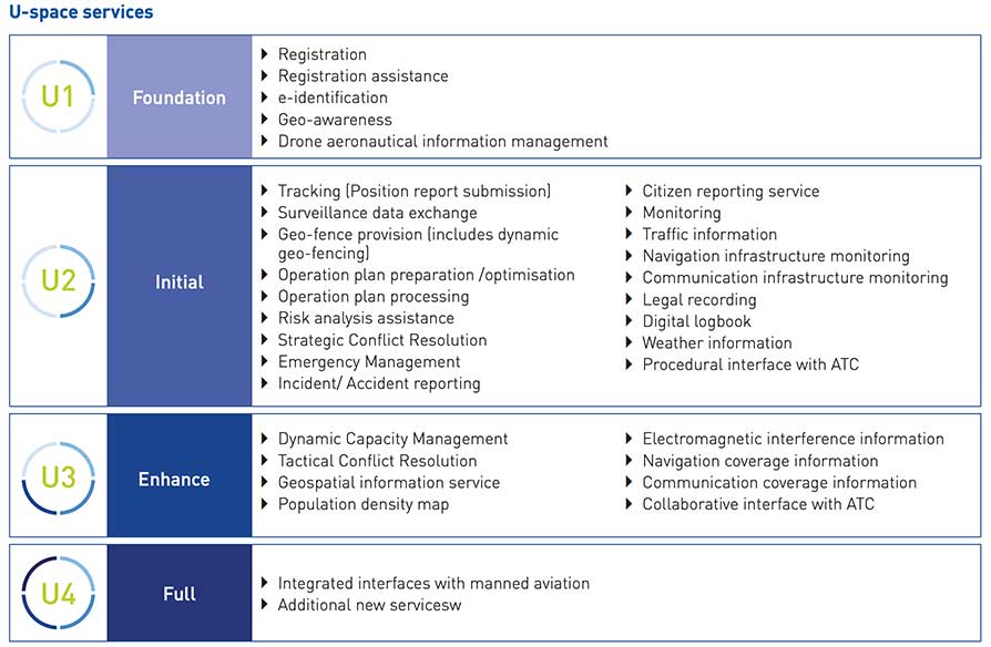
The projects map progress on development of the technological capabilities and all services
required for making U-space a reality, starting with foundation services (U1) before progressing to initial services (U2), advanced services (U3) and finally full services (U4).
Results of the projects summarized in the brochure will be fully detailed in a comprehensive report, expected to be published in the second half of 2020.
Chart: SESAR JC
SESAR 2020
SESAR 2020 is a European Union innovative program for researching the future of air traffic management in Europe. It builds on its predecessor, SESAR 1, to deliver high-performing operational and technological solutions for uptake by the aviation industry.
With a budget of 1.6 billion euros between now and 2024, SESAR 2020 will support projects to deliver solutions in these four key areas:
GMV has been awarded the SUGUS project (Solution for E-GNSS U Space Service), which aims to speed the adoption of GNSS and Galileo in the unmanned aerial vehicle (UAV) segment and ensure safe airspace access by unmanned aircraft.
SUGUS is an 18-month, 485,000-euro European Union research and development project. A series of trials will be held to show the benefits of E-GNSS for drone operators as well as its approval by aviation authorities.
The demand for UAV services is steadily increasing, with the potential to generate significant economic growth, as recognized in the 2015 European Union Aviation Strategy. More recently, the 2016 European Drones Outlook Study (by SESAR — Single European Sky ATM Research) estimated that the European drone market will clock up 10 billion euros a year by 2035 and more than 15 billion euros annually by 2050.
U-Space services
U-Space is a set of new airspace-management services and procedures designed to ensure airspace access too UAVs while looking out for operational security, the right to privacy and the safety of persons and infrastructure. These services rely on a high level of digitization and function automation, whether onboard the drone itself or part of the ground-based environment.
Several initiatives are underway in Europe to develop U-Space and work toward the safe and efficient coexistence of manned and unmanned air traffic.
At the same time, new European legislation on operating unmanned systems is providing a uniform, Europe-wide framework. The new regulation is broken down into three drone operation categories:
Open, calling for no AESA clearance or operator declaration
Specific, where both clearance and declaration will be necessary
Certified, reserved for riskier operations.
To help integrate drones into the airspace, SUGUS will center on the Open and Specific flight categories.
SUGUS tasks
SUGUS will demonstrate the benefits for drone operations of the measures implemented at service-provision level and the new EGNSS API (European GNSS application programming interface) to be implemented in the project.
These benefits included the mitigation of operating risks, improvement of preparation processes and clearance of the operator’s mission. Such measures as expected to ease future urban aerial mobility operations, such as aero taxis or parcel delivery.
For the first step in this endeavor, SUGUS will carry out a review of the results of previous EGNSS projects while also pinpointing the needs of drone operators and unmanned traffic service providers in complex operations and built-up areas.
This analysis will help to define and then implement the new EGNSS-based API.
SUGUS will also be running several flight trials in complex environments to prove the benefits of the drone-operation measures. The overarching idea is to raise awareness and contribute towards drone standardization and regulation to maximize the chances of the proposed services being implemented as a U Space service.
For an industry that makes its living identifying people and objects at a particular point in space, the geolocation industry — made up of applications providers, mapping companies and device manufacturers — has been very slow to make the move from two dimensions (2D) to three dimensions (3D). There is no excuse for this, as the ability to locate in 3D is fully tested and operable. What explains the holdup and what is being done to meet the growing need for 3D solutions?
Industry participants recognize the inevitable move towards 3D but give four main reasons for the delay:
There is a lack of awareness about some of the robust, scalable solutions that are available for deployment today
Businesses continue to make money from 2D applications
The investment required for 3D applications is too high
The eco-system for 3D applications is not fully developed
It seems that applications using location data simply rely on whatever information is made available through devices, mostly driven by GPS. There are more specific location technologies that offer fully tested, citywide vertical location solutions.
Despite years of deployments and generating effective use cases in two dimensions, the industry must do a better job of keeping up with technology advancements, especially those most likely to benefit from 3D location, and articles like this help!
But why is there a lag in the industry to move to a 3D world?
2D complacency
The explanation for the lag in moving to 3D is that the geolocation industry is still making money from 2D applications and, as the old saying goes, “If it’s not broken don’t fix it.”
While it’s true that many non-mission critical applications are getting along fine using 2D and will for the foreseeable future, the need for 3D is now. At a basic level, traffic directions don’t really require a 3D layout of the topography of your daily commute, although I could argue the traffic use case would benefit from knowing whether traffic on a map is on an overpass or ground level roadway. Certainly rideshare companies could benefit from communicating to their customers what level in a parking garage or airport they are on.
Other use cases are demanding more sophisticated 3D technology. One of the initial drivers for high-accuracy 3D (and indoor) location has been the needs of the public safety community. When lives are at stake, first responders require the most specific possible location accuracy in order to quickly find emergency callers and others needing help.
Beginning in April 2021, Emergency Communications Centers (911 call centers) will receive vertical location of emergency callers from wireless carriers. Computer-aided dispatch (CAD) systems are exploring how best to incorporate this information and direct first responders to the 911 caller’s 3D or floor-level location.
The benefit is obvious, as emergency callers cannot always provide their exact location to the 911 operator, so technology fills the gap. Other industries ranging from mining to healthcare to enterprise security similarly are also demonstrating demand for 3D applications, and we are seeing moves to meet this demand, but there is a long way to go.
High stakes
Another reason for the relatively slow development of 3D applications is the investment required. Even with a demonstrable demand across several industries, many players in the geospatial industry aren’t willing to invest funds to pioneer new solutions.
For every big player like Samsung or Apple, who have committed to developing state-of-the-art 3D sensors in their devices, there are many small players who must instead follow the market and adopt white-label solutions that don’t require as much upfront investment.
While it’s true that some 3D technologies can require significant investment and a committed strategy on the part of geospatial industry players, locating devices in 3D is possible today and there is a huge potential to serve new markets and improve business and consumer applications.
The 3D eco-system
As the market for commercial applications reaches a tipping point where 3D is not just a curiosity but is becoming a must-have for many consumers and businesses, the industry ecosystem must step up and deliver all parts of the solution. The mapping industry presents an interesting use case in this regard.
Digital maps have been in use for years, since the advent of the first fleet tracking devices in the 1980s, which led to the widespread use of consumer car tracking systems, and then onto Waze and other Smartphone-based mapping applications. Even these maps, which are huge advancements over their predecessors, do not fully reflect the 3D world we live in, and generally do not include accurate maps of the indoor environments in which we spend most of our time.
The next step in mapping is the digitization of entire buildings and other structures to create accurate 3D representations. However, even pioneers in this space aren’t fully utilizing 3D technology throughout their product roadmap, and, until there is a fully developed 3D ecosystem, it’s difficult for a company to go ahead alone.
As one leading company explained to us, without a consistent protocol for the use of 3D data and its conversion into 3D maps, they can’t justify converting their entire production from 2D, so they instead create 3D maps as one-offs where needed. They haven’t yet seen the critical mass in the industry required to go full 3D, and they are still working with, and making money from, 2D partners.
They are preparing for the time when the industry is fully 3D, which they believe will come soon.
A 3D world
Stepping back and taking a broader view of where we are, I think we are witnessing an industry in transition. With the deployment of city-wide, scalable location solutions that incorporate location data from a variety of sources, the initial building blocks are in place for the move to a fully 3D world.
Pioneering companies are going after growing demand (and in some cases creating that demand), even with limited resources, and seeding an ecosystem for others to build upon. I would in fact challenge the industry to produce a use case that would not benefit from improved location and 3D awareness — from the daily commute through complex freeway systems to shoppers navigating a multi-story mall to find a specific retailer, to protecting workers running large hotels, and more, the applications are endless and promise to multiply as users realize the benefits of 3D technology.
It is only a matter of time until the location industry will fully embrace the fact that the world indeed is not flat.
About Matt Rothschild
Matt Rothschild
Matt Rothschild is the Mountain View-based Head of 3D Location Customer Engagement for Polaris Wireless. He is a wireless and telecommunications industry leader with more than 20 years’ experience leading sales, marketing, product and operations organizations internationally. Rothschild successfully led sales and marketing teams for Nokia in Asia (Singapore), the Middle East & Africa (Dubai) and the Americas (Miami/Silicon Valley). Most recently, Rothschild led the Nokia/Microsoft acquisition and integration for North America, building partnerships with key mobile operators and channel partners, as well as building important ecosystem and developer relationships for the Windows platform.
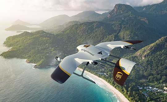
UPS Flight Forward (UPSFF) is collaborating with German drone-maker Wingcopter to develop the next generation of package delivery drones for a variety of use cases in the United States and internationally. UPSFF is a subsidiary of UPS dedicated to drone delivery.
UPS chose Wingcopter for its unmanned aircraft technology and its track record in delivering a variety of goods over long distances in multiple international settings.
“Drone delivery is not a one-size-fits-all operation,” said Bala Ganesh, vice president of the UPS Advanced Technology Group. “Our collaboration with Wingcopter helps pave the way for us to start drone delivery service in new use-cases. UPS Flight Forward is building a network of technology partners to broaden our unique capability to serve customers and extend our leadership in drone delivery.”
Drone fleet. As part of this collaboration — UPSFF’s first new relationship with a drone manufacturer since its formation — both companies will work toward earning regulatory certification for a Wingcopter unmanned aircraft to make commercial delivery flights in the United States. It also is a critical step toward building a diverse fleet of drones with varying capabilities to meet potential customer needs.
The Wingcopter drones feature vertical takeoffs and landings in tight spaces, transitioning to efficient, high-speed horizontal flight, enabling ranges suitable for a variety of uses. These capabilities will allow UPSFF to begin developing solutions that, if approved, will go well beyond the healthcare and retail industries to solve long-standing challenges for high-tech, industrial manufacturing, hospitality, entertainment and other customers.
Wingcopter drones have taken part in numerous beyond-visual-line-of-sight (BVLOS) projects and been used by diverse customers around the world — from commercial, factory-to-factory deliveries to life-saving humanitarian projects and emergency medical supply.
For example, Wingcopter delivered insulin to an Irish island in the North Sea that is frequently cut off from the mainland because of bad weather. On the South Sea island of Vanuatu, the start-up, on behalf of the local Ministry of Health and supported by UNICEF, successfully set up an on-demand vaccines supply, delivering the urgently needed serums within minutes to multiple different health centers.
Core innovation. The company’s electric vertical takeoff and landing drones have a patented tilt-rotor mechanism, which enables a seamless transition between two drone modes: multicopter for hovering and fixed-wing for low-noise forward flight. The aerodynamic Wingcopter aircrafts operate with stability even in harsh weather conditions.
In 2019, UPSFF began operating commercial drone delivery flights in the UPS network, starting with delivery service at WakeMed’s flagship hospital and campus in Raleigh, N.C. Since then, the company has delivered thousands of medical samples via drones, supplementing a ground courier service.
UPSFF later announced plans to establish drone delivery services on several healthcare campuses and has been exploring the use of drones to deliver retail, prescriptions and medical products in residential settings.
In September 2019, UPSFF received the U.S. government’s Standard Part 135 certification to operate a drone airline, and has also completed drone deliveries under the U.S. Federal Aviation Administration’s Part 107 rules within the FAA’s Integration Pilot Program.
“We are proud to partner with UPS, a global giant in delivery and logistics. Together we aspire to extend the speed and reach of package delivery,” said Tom Plümmer, Wingcopter chief executive officer and co-founder. “Our vision has always been to leverage technology to improve the lives of people around the world, and the strategic relationship with UPS will further accelerate our growth and global expansion, strengthening our role as an industry leader in drone technology.”
Septentrio is starting high-volume production of mosaic-X5, its next-generation multi-constellation and multi-band receiver module.
Featuring the company’s latest GNSS technology, mosaic-X5 brings centimeter-level positioning to technologies such as robotics, automation, smart wearables and telematics among others. Its small form factor and low-power design makes high-performance positioning accessible to volume applications, the company said.
“For smooth, uninterrupted operation in the field mosaic-X5 is the logical choice for an industrial-grade GNSS positioning module,” said Francois Freulon, head of Product Management at Septentrio. “In an industrial setting the cost of equipment downtime can quickly get out of hand. We designed mosaic to be robust in difficult environments, ensuring continuous operation as well as quick set-up times for our customers.”
Septentrio’s mosaic-X5 was conceived to be the first GNSS receiver module on the market without performance compromises. Featuring complete multi-frequency multi-constellation technology mosaic receives every existing and future signal from all GNSS constellations including the American GPS, European Galileo, Russian GLONASS, Chinese BeiDou, Japanese QZSS, Indian NavIC and L-Band satellites. Such signal diversity allows maximum positioning availability even in difficult environments such as near tall structures or under foliage.
The compact GNSS module features Septentrio’s proprietary Advanced Interference Mitigation (AIM+) technology, which shields the receiver from jamming and malicious spoofing. This allows machinery and robotics equipped with GNSS to keep on working, instead of being grounded by RF interference. mosaic-X5 also includes the unique RAIM+ integrity engine essential for safety-critical applications such as autonomous systems.
For those who want to try out the mosaic-X5, evaluation kits can now be ordered directly at shop.septentrio.com.
As a valued member of GPS World‘s family, we’d like to share with you a short update. COVID-19 is impacting all of us — individuals, businesses and communities — in unprecedented ways. GPS World continues to be here for you, and while working remotely, will deliver the same information resources across our print and web-based platforms. Consider bookmarking GPSWorld.com and GPSWorld.com/gps-world-coverage-of-COVID-19 or subscribe to GPS World‘s free resources, if you aren’t already receiving them.
Along with delivering the most relevant information GPS/GNSS professionals need to run their businesses, we will continue to share ideas and information to keep our industry moving forward. This moment in history affords us the opportunity to look at new ways to operate and stay connected with each other. With that said, we always welcome your inquiries, insights and ideas, so please reach out. We’d love to hear from you.
Sincerely, Marty Whitford Publisher & Editorial Director
GEO Business 2020 organizer Diversified Communications U.K. has decided to change both the venue and date for the event. The event will now be taking place Sept. 24-25 at ExCeL London.
According to show organizers, GEO Business is the U.K.’s largest geospatial event designed for those involved in the gathering, storing, processing and delivering of geospatial information.
“GEO Business is one of the most important business events for the geospatial industry,” said Carsten Holm, managing director of Diversified Communications U.K. “A lot of companies rely on it to meet new and current customers, so this decision has not been taken lightly. However, the response to the outbreak is unprecedented and I think many would agree that it is not a climate in which we want to hold the show. The success, as well as the safety of our exhibitors and visitors, have always been our priority and this continues to be the case. We have been overwhelmed with support on the decision to move the show to new dates, including from our show partners AGI, CICES, TSA, ICE and RICS.”
Portfolio Director Caroline Hobden also addressed the location change.
“After six successful years at the Business Design Centre, we have taken the decision to move GEO Business to the new venue ExCeL London,” she said. “As the show has continued to grow, we have been looking to move to an alternative venue in 2021. However, the current situation presented an opportunity to make the move ahead of plan this year. Best of all, this new tenancy keeps the show in the heart of London.”