The AUVSI Xponential trade show has been postponed due to COVID-19, with a tentative reschedule date planned for August.
AUVSI Xponential 2020 was scheduled be held at the Boston Convention and Exhibition Center May 4-7. AUVSI has identified Aug. 9-12 as tentative dates to reschedule the event.
AUVSI Xponential is a large event for the unmanned aerial vehicle (UAV) and unmanned, autonomous industries. Held for the past 47 years, the conference attracts more than 8,500 attendees and 700 exhibitors from around the world.
“Based on currently available information, and with the best interests of our members, exhibitors, attendees and the global community in mind, the AUVSI Board of Directors has made the difficult but necessary decision to postpone AUVSI Xponential 2020,” said Brian Wynne, president and CEO of AUVSI.
Plans to conduct Xponential 2020 in August may change given how rapidly the COVID-19 situation is evolving. In the meantime, AUVSI will provide updates as information becomes available.
“We will continue to actively assess all potential opportunities to best serve the needs of our community while delivering the world-class event you have come to expect from AUVSI,” Wynne said.
AUVSI has created an email address, [email protected], for submitting inquiries about the plans to reschedule Xponential 2020. The association’s staff will respond to questions and concerns about the conference as quickly as possible.
“We appreciate the incredible support, cooperation and patience we have received from the unmanned systems community as we work through this evolving global issue,” Wynne said.
UAVOS company is collaborating with King Abdulaziz City for Science and Technology (KACST), Saudi Arabia, on scientific research and development of a new Flight Control System (FCS). The FCS is designed to fit and leverage multi-mission, multi-domain UAV platforms.
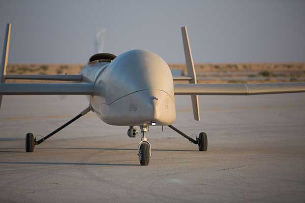
Together, the research and development (R&D) partners have created a Saker-1B Medium Altitude Long Endurance (MALE) UAS (unmanned aerial system). The specifications of the UAV system has been confirmed by more than 500 hours of day and night test missions under various weather conditions.
A total of 1,000 hours of take-off and landing test missions were successfully performed, with the long-endurance flights lasting up to 19 hours. The UAV is equipped with a satellite communication data link for beyond-visual-line-of-sight (BVLOS) operation.
Watch the Saker-1B in action:
UAVOS and KACST have been jointly developing Flight Control System capability for UAS for 10 years. R&D partners have completed performing the flight tests of their UAS in Saudi Arabia to verify easy and fully autonomous online and offline operation of the unmanned aircraft from takeoff to landing.
These test missions followed various other successful operational exercises performed in the last few months. The Saker-1B MALE UAS has been proven to operate in harsh desert with long-endurance, high-altitude and high-speed flights. High performance of satellite data link for command and control was demonstrated.
Due to availability of the current UAVOS autopilot technology, the UAS received sustainability to jamming attacks and advanced data security.
The Saker-1B performed a series of heavy weight landing tests with the maximum weight (MTOW) 2,500 pounds (1,100 kilograms). A number of different payloads were tested in surveillance experimental missions to confirm overall system performance and its readiness for real applications.
The UAS uses a direct radio link when flying within line of sight, switching seamlessly to a satellite link when flying BVLOS.
The Saker-1B MALE is an advanced unmanned aerial system with fully autonomous operation capability. It is equipped with automatic taxi-takeoff and landing systems, satellite communication for extended range, and fully redundant avionics.
The UAV is designed to operate in harsh environments and is adapted to perform in an extremely hostile, dry and dusty ambient air. The UAS is capable of flying for more than 19 hours at an altitude of up to 16,500 feet (5000 м) with a range 1600 miles (2600 km).
“We’re excited to work with KACST, a world-class organization in science and technology, fostering innovation and promoting a knowledge-based society in the Kingdom of Saudi Arabia,” said UAVOS CEO and Lead Developer Aliaksei Stratsilatau. “Our ultimate goal of the scientific research and development partnership is to make UAV technologies, which can turn vision into the UAV of tomorrow. For 10 years in partnering with KACST, we hold to a singular and enduring mission: to make breakthrough technologies for the unmanned system industry,”Aliaksei Stratsilatau added.
NASA Langley opened registration for its Safeguard with Autonomous Navigation Demonstration (SAND) Challenge, which will be held May 2020 in Hampton, Virginia. According to NASA Langley, the SAND Challenge will be an opportunity for small businesses to compete in an autonomous unmanned aerial vehicle (UAV) competition.
The challenge will address some of the safety critical risks associated with flying UAVs in the national airspace system.
NASA released the competition scenario, which reads: Hampton, Virginia, was hit by a large and devastating hurricane. The effect of the hurricane was to flood much of the area, knock down trees, damage houses/buildings, disrupt power lines and cause some injuries to residents. As part of the recovery effort, crews are working to locate incapacitated people, assess the damage to neighborhoods, look for downed power lines and determine the extend of the remaining flooding. To meet those objectives, both manned and unmanned aircraft are being leveraged to expedite the response. The Concept of Operations employed assumes UAS will remain within a specific volume of airspace to ensure the safety of unmanned aircraft operating in the vicinity, as well as the safety of first responders that are working in adjacent zones. UAS are assigned to specific areas to perform search and surveillance efforts. Safeguard provides range containment for vehicles independent of the UAS operator’s ability to monitor the vehicle, either by direct line of sight or through telemetered data. Its use for SAND is similar to beyond visual line of sight applications.
NASA Langley’s patented Safeguard technology will be used to help small business competitors mitigate such risks while they complete a set of complex mission profiles. For this competition, it will be configured to warn competitors (and auto-pilots) of impending excursions (or violations) while also objectively measuring performance with respect to the rules of the competition. The challenge will follow the Federal Aviation Administration Part 107 Regulation Small Unmanned Aircraft Regulations.
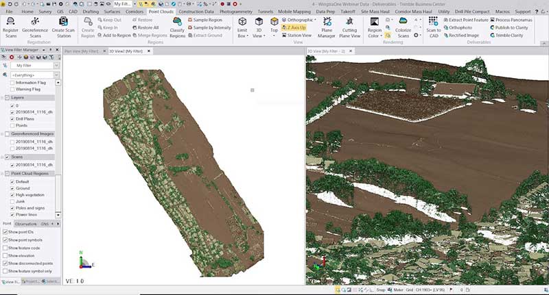
With Wingtra’s latest software release, surveyors and geospatial professionals can now directly import WingtraOne drone data into the Trimble Business Center (TBC).
According to Wingtra, the new integration seamlessly combines WingtraOne high-accuracy drone data within TBC, optimizing drone mapping workflows for survey and construction projects within a single software platform.
The integration allows users to drag and drop data into the software suite. Automated point cloud tools, such as classification and feature extraction, can then be used to quickly generate surface models, topographic plans and as-built deliverables.
Photo: Wingtra
“It’s a solid step forward to enable our data to work smoothly with Trimble Business Center,” said Francois Gervaix, Wingtra’s geospatial expert. “TBC is a reference software in the industry, because of its success as a data hub for construction and geospatial workflows. Optimizing the workflow lets TBC users smoothly integrate data from the fastest drone data capture platform on the market — WingtraOne.”
This latest Wingtra software release that introduced JobXML (TBC file format) compatibility also brought various other product updates. Namely, high-altitude flight capabilities, longer flight times and more intuitive battery level readings in-flight, Wingtra added.
The Center for Systems Science and Engineering at Johns Hopkins University is tracking the coronavirus, COVID-19, via an Esri ArcGIS map.
The map is updated in almost real time, and it includes a zoomable map identifying confirmed cases of the virus throughout the world. It also includes numerical data on how many cases have been confirmed in each country, as well as deaths and recoveries.
“In response to this ongoing public health emergency, we developed an interactive web-based dashboard hosted by the Center for Systems Science and Engineering at Johns Hopkins University, to visualize and track reported cases in real-time,” John Hopkins stated on its website. “The dashboard, first shared publicly on Jan. 22, illustrates the location and number of confirmed COVID-19 cases, deaths and recoveries for all affected countries. It was developed to provide researchers, public health authorities and the general public with a user-friendly tool to track the outbreak as it unfolds.”
Drone-maker DJI has filed an 89-page formal comment urging the U.S. Federal Aviation Administration (FAA) to allow drone pilots to choose which method of remote identification to use with their drones.
DJI’s filing includes an independent economic study that concludes the FAA’s Remote ID proposal would prove nine times as costly as the FAA’s estimates, imposing $5.6 billion worth of burdens on society over the next decade. The analysis finds many of those costs could be obviated if drone pilots could choose between two different methods of compliance, rather than doing both as the FAA proposed.
The economic analysis was prepared by Christian Dippon, Managing Director at NERA Economic Consulting, who considered the societal costs of the FAA’s proposed rule. He concluded the average monthly cost of a remote ID network-based service for a drone user would be $9.83, rather than the FAA’s $2.50 estimate; that demand for drones would fall 10 percent if the FAA’s proposals were imposed as written; and that total costs over 10 years would be $5.6 billion instead of the FAA’s $582 million estimate.
“We have known for years that Remote ID will be required by governments worldwide and will provide members of the public with confidence in productive drone uses, but the FAA’s deeply flawed proposal poses a real threat to how American businesses, governments, educators, photographers and enthusiasts can use drones,” said DJI vice president of Policy & Legal Affairs Brendan Schulman. “We hope our detailed economic analysis and comments, as well as tens of thousands of comments from other concerned parties, will encourage the FAA to develop a more risk-based, balanced and efficient remote ID rule, so our customers and the entire industry are not hurt by the final outcome.”
Remote ID allows authorities to identify and monitor airborne drones in near-real time, so they can see the location of the drone as well as a serial number to identify its owner. Congress tasked the FAA in 2016 with exploring consensus-based technology standards that could lead to Remote ID regulatory solutions.
In late 2019, the FAA proposed that almost all drones should broadcast that information directly to nearby receivers, as well as transmit it over wireless networks to a service provider’s database, with an anticipated monthly subscription fee for that service.
DJI and many other drone stakeholders have instead said the FAA should let drone operators choose whether to use broadcast or network solutions for Remote ID. Any new Remote ID rule is unlikely to take effect before 2024.
On Feb. 3, drone company Quaternium broke its own record for long flight time with a hybrid-fuel electric drone.
The Quaternium HYBRiX UAV took off at 08:52 a.m. in Valencia, Spain, and landed at 17:02 p.m., performing a stationary flight of 490 minutes.
The new endurance record of 8 hours and 10 minutes of non-stop flight time was accomplished with an experimental version of the company’s HYBRiX 2.1 drone, which carries 25 kilograms of maximum take-off weight.
Six years ago, the startup Quaternium developed its first hybrid fuel drone, inspired by hybrid cars from the automotive industry.
In 2015 the company flew its hybrid drone, the multirotor HYBRiX, for 3 hours and 10 minutes. According to the company, Hybrid multirotors multiply flight time more than 10 times compared to electric solutions.
The company has published a flight video with the demonstration of the record.
Most multicopter drones provide flight times of 25 to 40 minutes, with the pilot needing to carry multiple batteries into the field.
The HYBRiX project is supported by the European Union through its Horizon 2020 innovation program, which fosters disruptive projects in innovation, excellent science and industrial leadership. The project has received awards from institutions such as AUVSI, CDTI and the Spanish government.
The Quaternium team was motivated to develop a long-endurance drone because it will help first responders and and firefighters to identify hot spots and search for survivors in the event of a catastrophe, the company said in a press release.
1Spatial has released 1Data Gateway, an intuitive self-service web-portal for handling data validation, data processing and data enhancement.
1Data Gateway forms part of 1Spatial’s Location Master Data Management (LMDM) suite of products which ensures spatial data quality and consistency across the enterprise.
Available in the cloud or on-premise, 1Data Gateway offers internal and external users a secure, fully scalable and customisable product to handle both spatial and non-spatial data files. Transportation and infrastructure companies, government agencies, and utility companies are among the types of organisation that can utilise 1Data Gateway to help improve productivity, lower costs and guarantee control, compliance and data governance, for their data supply chains.
1Data Gateway applies 1Spatial’s renowned rules-based approach to help users manage their data. For organisations dealing with complex and varied supply chains, 1Data Gateway ensures data is checked at source. Using the centralised management of suppliers, partners and rules to create a collaborative approach, it promotes efficiency in data capture and submission across the supply chain.
Users simply upload their data files by dropping them onto the interface and 1Data Gateway applies the high-performance rules that have been pre-configured by an administrator in order to perform validation, correction or enhancement. This process means that users do not require training and can get results within minutes.
Once processed, results can be previewed on a map or downloaded into a local system. 1Data Gateway empowers administrators by providing analytics and dashboard capabilities to track and analyse the quality of the data that groups or organisations are submitting.
“We believe 1Data Gateway has the power to transform the manipulation of spatial data. We’re always driven by the needs of our customers, and in identifying the requirement for an easy to use, yet powerful portal for data quality and integration, we’ve developed 1Data Gateway,” Seb Lessware, CTO, 1Spatial said.
“Our customers need to unlock information contained within spatial data from multiple suppliers, in multiple formats, often submitted via different means. 1Data Gateway provides a single place for data submission, allowing the data to be validated, harmonised, cleaned and enhanced, making it fit for purpose and allowing the insight it can provide to be unlocked. It’s an exciting update to our product range, and should help revolutionise the way organisations manage their data flow.”
A link to the live event will be sent to you two hours before the event. Your personalized event URL will be automatically generated by the ON24 system. To ensure receipt of the email, please whitelist this email address by adding it to your contacts: [email protected].
This presentation will begin at 1 p.m. Eastern / 10 a.m. Pacific on Thursday, March 26. A recording will also be sent to you the following day so you can watch it on-demand.
Audience members may arrive 15 minutes prior to live time. If you have any questions, please contact event producer Kelly Limpert at [email protected]
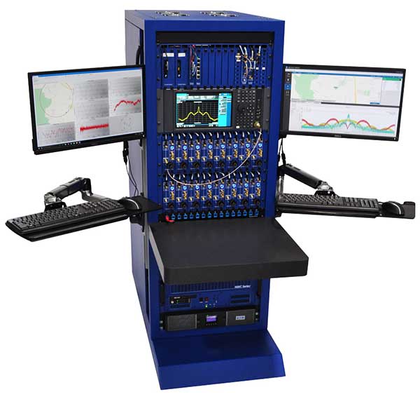
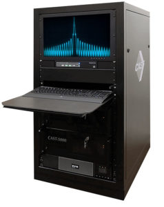
The CAST-5000 produces a coherent wavefront of GPS RF signals to provide repeatable testing in the laboratory environment or anechoic chamber. The basic system generates four independent, coherent simulations that reference a single point and is configurable to support up to eight elements for CRPA testing. With an intercard carrier-phase error of less than 1 millimeter, the CAST-5000 is extremely accurate.
The system generates a wavefront of GPS when its GPS RF generator cards are operated in a ganged configuration. Each generator card provides a set of GPS satellites coherent with the overall configuration. Several RF generator cards may be utilized together, ensuring phase coherence among the bank of signal generator cards. The CRPA antenna, antenna electronics and the GPS receiver can be tested as a unit with or without radiating signals.
The CAST-8000 is a new simulator that merges the CAST-5000 CRPA tester with a CAST-3000 EGI tester. The CAST-5000/8000 has the ability to be “ganged” together with additional CAST simulators to provide multiple vehicle and/or multiple antenna test configurations.
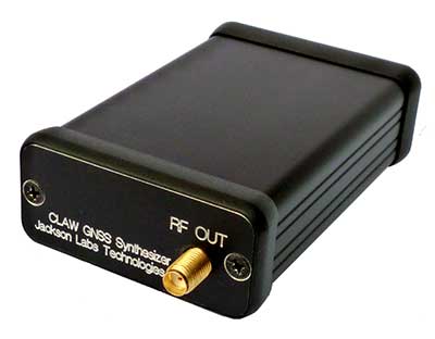
The 18-channel miniature full-constellation CLAW GPS Simulator is a fully self-contained, low size, weight, power and cost (SWaP-C) miniature GPS simulator. It is very popular in manufacturing environments as well as R&D applications that require consistent and repeatable local GNSS signals at low price points.The CLAW simulator does not require external computers for processing and control — it works fully self-contained by simply applying power, and storing location/time/date data in internal non-volatile (NV) memory, or by storing complex vector data to simulate highly dynamic scenarios. The CLAW also can be used to transcode NMEA or SCPI position/velocity/time (PVT) data into GPS RF signals. JLT offers an easy to use, highly configurable and cost-free SimCon Windows application program that is downloadable from the JLT website.
The SimConapplication allows random scenario generation and is thus usable to simulate leap-second events, week 1023 rollover events, or any other GPS live-sky scenarios including highly complex yet easy-to-create dynamic vector simulations. For authorized U.S. government users, a version that does not have altitude and velocity limitations is popular for low-Earth-orbit (LEO) simulations. Multipath simulation allows use of the entire 18-channel simulator capability. The unit can be field-upgraded with an easy to use in-field software upgrade feature. The CLAW is also very useful in GNSS receiver sensitivity testing for R&D or mass-production assembly lines as it allows accurate control of RF output power ranging from –100 dBm to less than –130 dBm with 0.1-dB resolution and typically better than 1-dB accuracy over the controllable power range.
The CLAW GPS Simulator also has a built-in RF signal generator with sweep, CW and random noise functions that are useful in simulating GNSS jamming scenarios, as well as GPS spoofing scenarios. The simulator comes in an FCC-certified metal desktop enclosure with numerous accessories.
The Orolia family of GNSS simulators offers a wide breadth and depth of tools for those responsible for mission-critical positioning, navigation and timing (PNT) applications. The simulation tools enable users to test a variety of scenarios, from simple to complex. Orolia’s simulators are feature-rich and easy to use, offering a way to harden GPS/GNSS-based systems without the limitations of testing from live-sky signals. Orolia’s approach allows users to buy only what they need today and upgrade later.
ESSENTIAL
Photo: Orolia
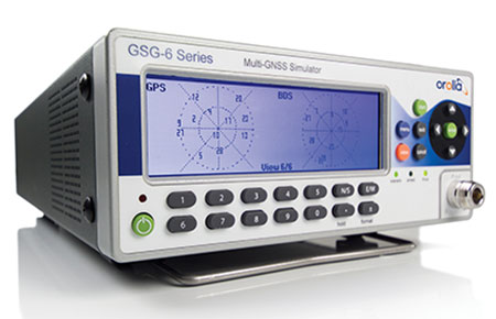
GSG 5/6. An essential scenario-based simulator used for testing a variety of smart applications such as drones, the internet of things (IoT), connected cars, cellular and more. GSG 5/6 offers ease-of-use with an out-of-the-box configuration and comprehensive set of pre-defined scenarios, plus the ability to create scenarios. It can simulate all constellations, all frequencies, and movements/trajectories anywhere on or above Earth. This enables a multitude of test solutions covering accuracies and sensitivities due to environmental conditions, technology factors and other events. Application packages are available for real-time kinematic (RTK), eCall, high-velocity, jamming and sensors.
ADVANCED
Skydel Software Engine. The software behind Orolia’s high-end GNSS simulators: GSG-8, BroadSim, BroadSim Anechoic and BroadSim Wavefront. All share the same software-defined benefits and interoperability. In addition to Orolia’s turn-key systems, Skydel can run on the user’s own commercial off-the-shelf (COTS) hardware. It is suitable to test and validate GNSS systems for a variety of applications, with advanced signal customization and configurable outputs. Users can create advanced scenarios with multiple parameters and variables: antenna patterns, orbits, multipath, hardware-in-the-loop (HIL) and more. The easy-to-use API configures all aspects, available in Python, C#, C++ and LabVIEW. User interactions can be recorded and exported as executable Python script — a learning tool that drastically reduces the automation learning curve.
Photo: Orolia
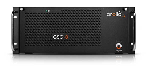
GSG-8. An advanced software-defined GNSS simulator supporting multiple constellations, frequencies and hundreds of signals all-in-view. With a 1000-Hz iteration rate, high dynamics and real-time synchronization, GSG-8 delivers ultra-high performance and flexibility. It is designed for space trajectories, custom PNT signals, HIL and more. Advanced jamming and spoofing options allow users to create benign and threat scenarios required for critical applications. Complex objects such as Differential GNSS (RTK), multi-antenna vehicles, attitude measurements and sophisticated GNSS receivers can be tested. A comprehensive software development kit (SDK) allows users to incorporate encrypted or proprietary signals. Powered by the Skydel Simulation Engine.
Photo: Orolia
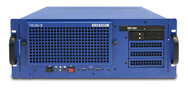
BroadSim. Available through Orolia Defense & Security, BroadSim was designed to meet the demand of NAVWAR testing. BroadSim supports high dynamics, advanced jamming and spoofing simulation tools, and encrypted military codes including Y-code, M-AES and M-MNSA. BroadSim uses a custom Linux operating system for security and better performance. BroadSim excels in NAVWAR applications due to its four independent RF outputs, a wide dynamic range with up to 0 dBm transmit power, and integrated jamming and spoofing scenario creation. BroadSim’s ease-of-use and functionality to configure multiple vehicles allows any user to seamlessly test the performance and vulnerability of their system without requiring a high level of expertise. Powered by the Skydel Simulation Engine.
Photo: Orolia
BroadSim Anechoic. Available through Orolia Defense & Security, BroadSim Anechoic enables users to accurately simulate over-the-air (OTA) GNSS environments in their anechoic chamber. Designed from the ground up for the user, by users, the system has 32 individual RF outputs enabling it to drive 16 dual-frequency antennas. The automation of antenna mapping, time delay and power loss calibration cuts set-up time from days to minutes. Easily verify signals with a built-in spectrum analyzer. The 48-dB transmit chain amplifier and 80-dB transmit chain dial attenuator allow for complete signal control and high dynamic range. Powered by the Skydel Simulation Engine.
Photo: Orolia
BroadSim Wavefront. Available through Orolia Defense & Security, BroadSim Wavefront enables fully featured testing of controlled reception pattern antenna (CRPA) and multi-element antenna electronic systems. Scaled upon the same easy-to-use software-defined platform and interface, it supports 4-16 antenna elements with integrated high dynamics and a phase coherence of 1° σ. Users can simultaneously simulate multiple spoofers, jammers, repeaters and alternate PNT sensors with just a few clicks. The Wavefront makes no compromise between the number of signals and the iteration rate, which remains at 1,000 Hz. It is designed to help engineers deliver results and make decisions, and can be calibrated in a matter of minutes. Powered by the Skydel Simulation Engine.
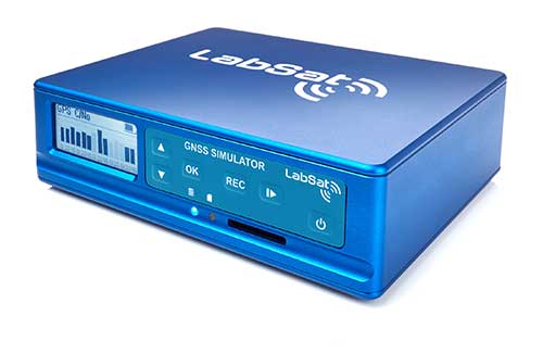
The LabSat 3 Wideband is a compact yet powerful multi-constellation and multi-frequency GNSS testing solution.
The easy-to-use, one-touch record and replay function provides an efficient way to test and develop GNSS-based technology without the cost and limitations of live-sky signals.
With simple-to-install upgrade options available, customers can invest with the confidence that its capabilities can grow alongside their future requirements.
LabSat 3 Wideband can record and replay up to three different channels at 56-MHz bandwidth across all major constellations and signals including:
GPS: L1/L2/L5
GLONASS: L1/L2/L3
BeiDou: B1/B2/B3
QZSS: L1/L2/L5
Galileo: E1/E1a/E5a/E5b/E6
L-band correction services including SBAS and IRNSS
2x CAN, RS232 and digital inputs tightly synchronized with GNSS data
Future signal launches are also supported, including L2C, L5 and L1C
LabSat 3 Wideband has a removable SSD (up to 7TB) and a two-hour runtime provided by an internal battery. It is lightweight and portable, making it ideal for field testing in any environment.
SatGen Signal Simulation Software
SatGen software allows users to quickly create bespoke, accurate scenarios with their own time, location and trajectory, that can be replayed via a LabSat GNSS Simulator.
The latest version of SatGen can be used to create a single scenario containing all the upper and lower L-Band signals for GPS, Galileo, GLONASS and BeiDou.
Precision-sensitive applications such as autonomous driving, control of unmanned aerial vehicles (UAV), or positioning of aircraft during landing procedures in coordination with ground-based augmentation systems (GBAS) require that modern GNSS receivers undergo detailed tests before implementation.
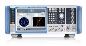
Rohde & Schwarz signal generators like the R&S SMW200A and the R&S SMBV100B offer a unique approach to generating complex and highly realistic scenarios for testing of GNSS receivers that are able to work with diverse navigational systems such as GPS, GLONASS, Galileo, BeiDou and QZSS/SBAS signals. Both simulators can emulate them all for testing.
R&S SMW200A. The R&S SMW200A GNSS simulator (pictured above) can be used to produce complex interference scenarios with multiple interferers — all generated within the instrument itself. It can emulate up to 144 GNSS channels and can be equipped with up to four RF outputs. With its ability to simulate multi-constellation, multi-frequency, multi-antenna and multi-vehicle scenarios, the R&S SMW200A is able to cover a variety of high-end GNSS applications.
R&S SMBV100B. The R&S SMBV100B supports the same navigational systems, with access to 60 GNSS channels and one RF output, with the same ability to configure realistic scenarios including obscuration, multipath and atmospheric effects, as well as the specific characteristics of the antenna and the simulated vehicle. An integrated noise and CW interference generator also can be added.
Since the devices do not require an external PC for scenario configuration, all the tests can be created quickly through the user-friendly GUI. Due to all-encompassing instrument options available, both simulators can be set up to fit unique user requirements.
For testing GNSS receivers under controlled and repeatable conditions, the R&S SMW200A and the R&S SMBV100B provide extensive and cost-effective solutions. The platforms are ready to adapt to future requirements and testing of newly implemented GNSS signals.
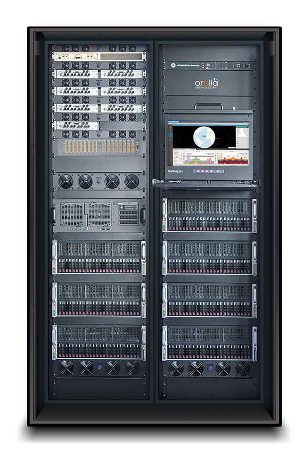
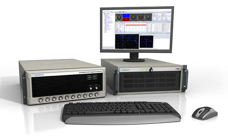
GSS9000, SimMNSA, CRPA test system, anechoic chamber testing, mid-range testing
Photo: Spirent Federal
Spirent Federal provides GPS/GNSS test equipment that covers all applications, including research and development, integration/verification and production testing.
GSS9000. The enhanced GSS9000 Multi-Frequency, Multi-GNSS RF Constellation Simulator is Spirent’s most comprehensive simulation solution. It can simulate signals from all GNSS and regional navigation systems and has a system iteration rate (SIR) of 1000 Hz (1 ms), enabling higher dynamic simulations with more accuracy and fidelity. The GSS9000 supports restricted/classified signals. Users can evaluate the resilience of navigation systems to interference and spoofing attacks, and have the flexibility to reconfigure constellations, channels, and frequencies between test runs or test cases.
SimMNSA. The first fully approved MNSA M-code simulator. Authorized users of the GSS9000 series of simulators will be able to utilize the advanced capabilities of SimMNSA to create more robust solutions for their customers. SimMNSA has been granted Security Approval by the Global Positioning System Directorate.
CRPA Test System. Spirent’s Controlled Reception Pattern Antenna (CRPA) Test System generates both GNSS and interference signals. Users can control multiple antenna elements. Null-steering and space/time adaptive CRPA testing are both supported by this comprehensive approach.
Anechoic Chamber Testing. Spirent’s GSS9790 Multi-Output, Multi-GNSS RF Constellation Wave-Front Simulator System is a development of the GSS9000. The GSS9790 is a unique solution providing the core element for GNSS applications that require a test system that can be used in both conducted (lab) and radiated (chamber) conditions.
Mid-Range Solutions. Spirent also offers solutions that cater to intermediate GPS/GNSS testing needs. The GSS7000 multi-constellation simulator provides an easy-to-use solution for GNSS testing that can grow with users’ requirements. The GSS6450 RF record and playback system enables replay of a real-world GNSS/GPS test repeatedly in the lab.
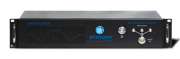
High-end GNSS simulation solutions for R&D, integration and production testing
Photo: Syntony GNSS
Constellator. Syntony’s GNSS simulator Constellator supports all constellation signals available and provides a high level of service in different ranges. It covers, in a single unit, a wide spectrum of use cases from entry-level with L1C/A up to very demanding configurations such as multi-frequencies and 400 channels management.
Extensively used in aeronautics, space and defense industries, Constellator answers complex requirements:
Standalone mode (on the ground and in space)
Multi-frequencies
All constellations and their signals, including NavIC/IRNSS
Hardware in-the-loop (HIL) mode with zero-effective latency and 1000-Hz update rate
All typical synchronization interfaces
Particularly in the space industry, Constellator implements the advanced models (Earth gravity, drag, 3D ionospheric models, side lobes, etc.) needed to achieve accurate simulations for all kinds of orbits (from LEO to GEO and SSTO). Combined with other Syntony GNSS simulation products (interference generator, Recorder & Player Echo, GBAS simulator, etc.), Constellator can be used to tackle challenging use cases such as jamming, spoofing, multipath, and multiple antennas testing. Constellator is based on a software-defined radio (SDR), making it hardware-ready for future constellations, signals and codes. It is easily upgradeable and versatile.
GNSS Recorder & Player. Syntony’s Echo is an ultra-high-fidelity GNSS recording and playback solution. It is designed to capture real-life signals and environments, for instance from airplanes, and then replayed for R&D or production tests. Echo offers:
3 RF channels of 100-MHz bandwidth each (for the whole set of GNSS signals from all constellations)
16-bit resolution (I&Q)
from 7 to more than 1,000 hours of record/replay capabilities depending on configuration
Echo-R can also record complex and very long realistic scenarios from a simulator; Echo-P can replay them with very high fidelity for long-run or production tests. Please ask Chief Sales Officer Francois Goudenove for distributor contacts in the U.S., Europe, India, China, South Korea and Japan.
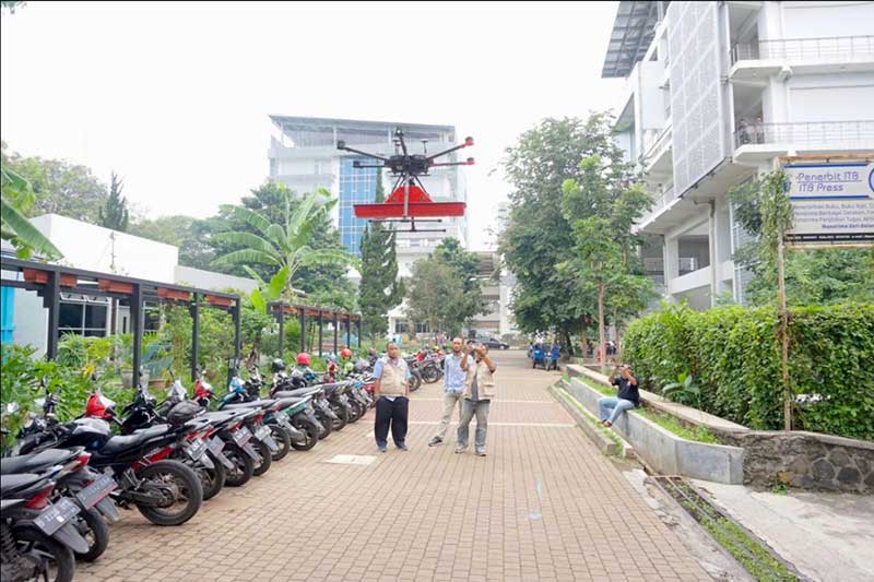
Terra Drone Indonesia, a group company of Japan-based Terra Drone Corp., has successfully completed a pilot project at the Bandung Institute of Technology (ITB) in Indonesia. The project included flying a drone equipped with a Ground Penetrating Radar (GPR) system over the campus to map tunnels and underground utilities.
The drone data was then processed and compared with the infrastructure records of the university by geophysicists, who determined the underground assets were accurately and precisely mapped, Terra Drone Indonesia said.
According to Terra Drone Indonesia, the combination of GPR and drones opens up new potential for the use of unmanned technologies in areas that are traditionally challenging and unsafe, such as post-blast areas in open-pit mines. A GPR drone also could be used to locate underground pipes, map the conditions of the assets and detect hazards like pipeline leaks.
“The conventional GPR method requires field personnel to go to the field and carry GPR tools to conduct surveys,” said Michael Wishnu Wardana, managing director at Terra Drone Indonesia. “But this method has its own dangers because not only are some areas unsafe and difficult to reach, but also because severe weather conditions in the field can hamper workers from carrying out their jobs diligently. GPR drones, in contrast, have emerged as a much safer and efficient surveying solution.”
Terra Drone Indonesia worked on this project in collaboration with PT Airborne Geophysics Indonesia and the Geophysics Laboratory at ITB. TerraDrone Indonesia has worked with ITB in the past as well, validating Terra Lidar’s topographic mapping capabilities at ITB’s Jatinangor Campus.
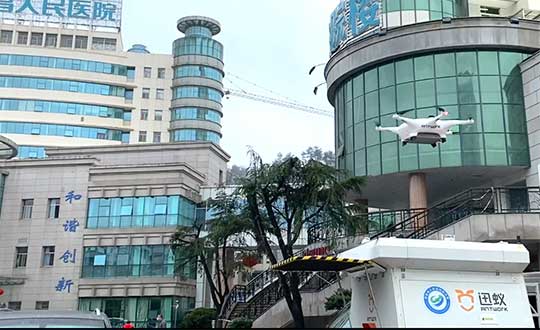
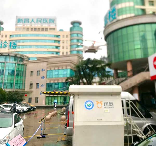
Through its group company Antwork, Japanese company Terra Drone is employing its UAV system to transport medical samples and quarantine supplies in China to fight the coronavirus.
At 9 a.m. on Feb. 6, a medical delivery drone flew from the People’s Hospital of Xinchang County to the disease control center of Xinchang County, marking the launch of the first urban-air transportation channel to help to fight the novel coronavirus (COVID-19 ), a global health emergency.
Take off and landing point of Xinchang people’s Hospital. (Photo: Terra Drone)
The World Health Organization reports at least 95,270 people are infected and at least 3,280 have died. China, where COVID-19 originated, is in a tense period of epidemic prevention and control. Xinchang County is in Zhejiang province — one of the areas most severely hit by the virus.
As soon as the Wuhan quarantine began on Jan. 23, Antwork petitioned to provide drone technical support.
Antwork’s RA3 and tr7s drones and unmanned RH1 station are ensuring that medical samples and quarantine materials can travel with minimal risk between Xinchang County People’s Hospital and Xinchang County’s disease control center. The automatic, unmanned air delivery system significantly reduces contact between samples and personnel, as well as improves delivery speed.
Antwork branch company Aerodeli, which undertook the operation, obtained the first urban drone delivery license issued by the Civil Aviation Administration of China (CAAC) in October 2019. The sample delivery work is carried out in strict accordance with certified operation procedures to ensure the safety of medical samples during transportation.
Take off and landing point of disease control center of Xinchang County. (Photo: Terra Drone)
Using drones has increased the speed of transport by more than 50% compared to road transportation, proving to be a more efficient means of transportation for epidemic prevention and control. The drones also relieve the personnel shortage as more and more medical staff and ambulances are transferred to the front lines — making the best use of human and material resources.
After the project for Xinchang People’s Hospital was put into operation, Antwork began assisting more medical institutions in China to deploy drone transport services for the anti-epidemic effort.
A drone departs from the disease control center of Xinchang County. (Photo: Terra Drone)