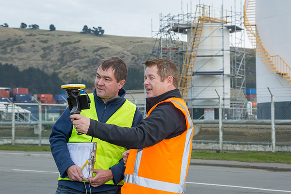
Verified photomontages for UNESCO World Heritage sites achieves accuracy with Spectra Geospatial SP80
Verified photomontage is an important planning tool to envision how proposed surrounding development plans would affect UNESCO World Heritage sites. Verified photomontage demands the best accuracy for the best visualization to determine what a development may look like to a person standing at the photographic viewpoint.
For MS Environmental (MSE), selected to provide verified photomontage for multiple UNESCO World Heritage sites, including in the UK Royal Botanical Gardens at Kew and the City of Bath, the Spectra Geospatial SP80 GNSS receiver enabled the highest quality visualization.
“The one-centimeter accuracy delivered by the SP80 is essential,” said Mike Spence, a verified photomontage specialist and founder of MSE. “The highest level of accuracy in the relationship between the actual camera location and the 3D model camera gives confidence in the visualization. In addition, The SP80 offers both simplicity and a robust design though it’s taken a few knocks over the years, it gives us the confidence we can use the equipment anywhere in the world and get the best results.”
At Kew Gardens, MSE was commissioned to produce accurate visualizations of views from within the UNESCO World Heritage Site. There was concern about development proposals for tall tower blocks in west London and how these might affect historic views from Kew Gardens.
The work culminated in a public inquiry, where evidence was presented that showed how views would change as a result of the proposed development. “Without the level of accuracy provided by the SP80 together with a transparent technical methodology it would have been unclear precisely how these historic views would change,” Mike Spence said.
At the UNESCO World Heritage City of Bath, the Bath and North East Somerset Council commissioned MSE to produce technical photography from strategic views around the World Heritage City to show how development proposals would affect strategic views across the city.
Course takes learners on a deep dive into concepts and applications
Esri logo
Esri will offer a new massive open online course (MOOC) on spatial data science early this year. The no-cost course, which will run for six weeks on Esri’s Training website, includes full access to ArcGIS Pro, ArcGIS Online and ArcGIS Notebooks software.
Spatial Data Science: The New Frontier in Analytics opens on Feb. 26 and provides a comprehensive introduction to how incorporating location enhances traditional data science workflows.
“Spatial data science builds on foundational data science techniques and adds the spatial perspective that really makes a huge difference in the outcomes of an analysis,” said Lauren Bennett, software development lead on Esri’s spatial analysis and data science team.
The course includes video presentations by Esri experts, discussion forums, and hands-on software exercises. Participants will discover how including spatial data and spatial analysis tools and techniques can dramatically improve predictive modeling, uncover previously hidden patterns, and solve problems.
“At its core, spatial data science is about solving problems,” Bennett continued, “using spatial algorithms, taking the latest and greatest techniques (statistics, machine learning, deep learning) and all the tried and true, more traditional techniques to turn data into information.”
Each section of the course will focus on a specific topic and application of spatial data science. From data engineering and visualization to suitability modeling, pattern detection, space-time pattern mining, and object detection with deep learning, participants will explore a wide range of scenarios using realistic data and powerful ArcGIS tools.
While many practitioners emphasize craft when sharing results, course authors champion the notion that successful analysts and data scientists must be able to effectively communicate the impact of their work with leaders and colleagues. For this reason, the final section of the course will explore the use of ArcGIS StoryMaps to craft visually appealing and information-rich narratives that resonate.
Spatial Data Science: The New Frontier in Analytics is open to learners worldwide. All that’s needed to attend is an Esri account, which is free and easy to create at accounts.esri.com.
Participants with a background in statistics, data science and Python are encouraged to attend, but anyone interested in exploring technology hot topics and learning the latest analytical capabilities of ArcGIS software will benefit as well. A certificate of completion will be awarded to all participants who finish the course.
Swift Navigation, a firm specializing in GNSS positioning technology for autonomous vehicles, looks back on a year of progress in 2019 and forward to what’s ahead in 2020.
2019 highlights include the expansion of operations to Australia, continued Firmware Releases to improve Swift’s multi-band, multi-constellation GNSS receivers, the expansion of Skylark cloud corrections service across the United States and announcing a partnership with Arm to bring precise positioning technology to autonomous vehicle compute platforms.
While Swift is proud of these accomplishments, the company is most excited about its shift from a company providing RTK GNSS receivers to one that provides a full ecosystem of precise positioning GNSS solutions for autonomous and mass-market applications.
Swift has made it possible for customers and partners alike to incorporate Swift’s patented technology into a multitude of autonomous platforms.
From the receiver-agnostic Starling positioning engine that enables the accuracy of Swift GNSS receivers and opens it up for industry use, to cloud-based corrections delivered nationwide with Skylark, Swift is poised to bring precise positioning to those who can benefit from centimeter-level location accuracy the most — autonomous platforms and applications.
While Skylark and Starling work independently with many leading industry components and receivers, it is the two paired together that makes the precise positioning powerhouse that will make 2020 a pivotal year for Swift.
At this year’s CES, the following Swift partners and customers are showcasing how they are integrating Swift’s precision positioning solutions in their platforms:
Arm — a global leader in semiconductor IP — utilizes Starling to deliver a high-integrity, high-accuracy GNSS positioning solution enabling automotive OEMs, as well as Tier 1 and 2 auto suppliers, to integrate precise positioning into their sensor suite. Arm is hosting meetings by appointment on Level 2 of the Venetian at Veronese 2505 and Veronese 2506.
STMicroelectronics — a global semiconductor leader — provides GNSS measurement engines and ASIL-rated processors for autonomous driving and high-accuracy GNSS solutions. ST has integrated Starling on the ST ASIL-rated Telemaco Platform for OEM applications. ST is hosting meetings by appointment only at their Hospitality Suites during CES 2020.
Aceinna — a provider of sensing solutions — announced its OpenRTK330 precise positioning module at CES. The new OpenRTK330 is based on the ST TeseoV receiver and includes three ST ASM330LHH IMUs for inertial measurements. Skylark is the preferred corrections provider for the OpenRTK330 and evaluation kits. Aceinna will be demonstrating its new module in booth 6738 in the North Hall Automotive pavilion.
See Swift in action at the CES locations above or contact the Swift team at [email protected] to schedule a meeting.
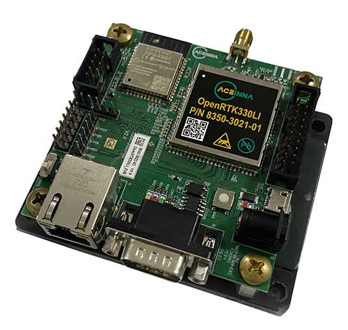
Module designed for developers creating guidance and navigation systems for autonomous vehicles, robots, drones, industrial, construction and agricultural machinery
Aceinna launched its OpenRTK330L at CES 2020, the massive annual consumer electronics show taking place Jan. 7-10 in Las Vegas. The company is located at Booth 6738, CES North Hall, Automotive Pavilion.
OpenRTK330L is a low-cost,high-performance triple-band RTK/GNSS receiver with built-in triple redundant inertial sensors. Designed to replace the expensive and bulky precision RTK/INS systems used in today’s autonomous systems, the compact navigation solution meets the challenging performance, reliability and cost requirements of the automotive market along with the needs of robot, drone, construction and agriculture systems, Aceinna said.
Demonstration Drive
Aceinna is demonstrating its GNSS/INS-based autonomous vehicle localization technologies on its test vehicle, which drove from Silicon Valley to Las Vegas.
The company is recording live drive-test data that demonstrates how its precision positioning solutions provide high accuracy and reliability. Precision location capability is critical for all levels of autonomous driving.
OpenRTK330L includes a triple-band RTK/GNSS receiver coupled with redundant inertial sensor arrays to provide cm-level accuracy, enhanced reliability, and superior performance during GNSS outages.
The OpenRTK330L integrates a precise 2 Degree/Hour IMU to offer ten to 30 seconds of high accuracy localization during full GNSS denial. This enables autonomous system developers to safely deliver highly accurate localization and position capabilities in their vehicles at prices that meet their budgets.
Image: Aceinna
OpenRTK330L’s embedded Ethernet interface allows easy and direct connection to GNSS correction networks around the world. OpenRTK330L’s CAN bus interface allows simple integration into existing vehicle architectures.
The multi-band GNSS receiver can monitor all global constellations (GPS, GLONASS, BeiDou, Galileo, QZSS, NAVIC, SBAS) and simultaneously track up to 80 channels. The module has RF and baseband support for the L1, L2 and L5 GPS bands and their international constellation signal equivalents.
The inertial measurement unit and dead reckoning function contains a total of 9 accelerometer and 9 rate gyro channels based on Aceinna’s unique triple redundant six-axis IMU array. By integrating a triple-redundant IMU array, the OpenRTK330L is able to recognize and utilize only valid sensor data, ensuring high-accuracy protection limits and certifiability under ISO26262 standards.
Open Navigation Platform
“The combination of a triple-band GNSS receiver and a high-precision IMU has enabled us to make a remarkably accurate, small, reliable and cost-effective GNSS/INS solution,” said Mike Horton, CTO of Aceinna. “The OpenRTK Precise Positioning Engine optimizes satellite tracking and high RTK fixes rates while integrating seamlessly with Aceinna’s open-source, developer-friendly Open Navigation Platform.”
The Open Navigation Platform allows custom embedded application development on top of Aceinna’s positioning engine and dead-reckoning algorithms. Autonomous solution developers have full access to all resources on the OpenRTK330L module including the GNSS receiver measurement data, IMU measurement data and all interfaces.
The OpenRTK330L GNSS receiver supports GPS (L1 C/A, L2C and L5), GLONASS (L1OF, L2OF), BeiDou (B1I, B2I), GALILEO (E1, E5a, E5b, E6) QZSS (L1 C/A), and NAVIC. The IMU sensor array includes a triple-redundant, 3-axis MEMS angular rate sensor, and a triple-redundant, 3-axis MEMS accelerometer.
Hardware also includes, Ethernet, UART, SPI and CAN interfaces for versatile integration into a host system. Additional specifications include operating temperature range of -40C to +85C, and qualification to standard automotive shock and vibration levels.
The U.S. Department of Transportation’s Federal Aviation Administration issued a proposed rule that would require unmanned aircraft systems (UAS) to be identifiable remotely.
The rule, deemed the “Notice of Proposed Rulemaking for Remote Identification,” would apply to all drones that are required to register with the FAA (recreational drones weighing under 0.55 pounds are not required to register), as well as to persons operating foreign civil UAS in the U.S.
“Remote ID technologies will enhance safety and security by allowing the FAA, law enforcement and federal security agencies to identify drones flying in their jurisdiction,” said U.S. Transportation Secretary Elaine Chao.
According to the FAA, nearly 1.5 million drones and 160,000 remote pilots are registered with the administration. Equipping drones with remote identification technologies would build on previous steps taken by the FAA and the UAS industry to safely integrate operations, including the small UAS rule, which covers drones weighing less than 55 pounds, and the Low Altitude Authorization and Notification Capability, which automates the application and approval process for most UAS operators to obtain airspace authorizations, the FAA added.
“As a pilot, my eye is always on safety first,” said FAA Administrator Steve Dickson. “Safety is a joint responsibility between government, pilots, the drone community, the general public and many others who make our nation so creative and innovative.”
The proposed rule will be accompanied by a 60-day comment period to receive public feedback and help the FAA develop a final rule to enhance safety in the skies over the U.S.
Hitec stated in a press release, “SUI’s experience in engineering and manufacturing small unmanned aircraft systems contributes perfectly with our expanding unmanned product platforms and progressive mapping and data acquisition solutions.”
Hitec Commercial Solutions continues to obtain integral assets which strengthen those products utilized for efficient surveying in agriculture, energy and gas, public safety, construction and first response services.
The acquisition agreement was closed Aug. 9 after approval by core members of the board of directors.
Hitec offers a variety of unmanned platforms, including the XENO FX, its proprietary fixed wing platform. The company also partners with Quantum Systems.
Founded in 2015, SUI provides technology in professional-use small unmanned aircraft systems (sUAS) with its Endurance and Endurance LT customized multirotor packages and ground controller system.
A roundup of recent products in the GNSS and inertial positioning industry from the December 2019 issue of GPS World magazine.
OEM
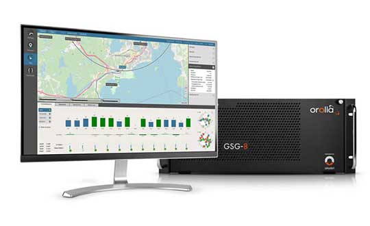
GNSS simulator
Testing for signals and sensors
Photo: Orolia
The GSG-8 is an advanced software-defined simulator that offers ultra-high performance and flexibility in an easy-to-use format. It was developed to deliver the highest standard of GNSS signal testing and sensor simulation performance in an upgradable, scalable platform. The GSG-8 uses the robust 1000-Hz Skydel software engine. It is designed for customers who require complex capabilities to validate product and program performance in harsh, high-risk environments where failure is not an option, such as government agencies, space programs and specialized commercial programs.
The Edge Locate GNSS L1/L2/E5 module combines antenna, RF electronics and receiver technology to deliver reliable centimeter-level positioning for the internet of things (IoT). It provides 1- to 3-centimeter-level accuracy using multi-band GNSS technology. With Edge Locate, manufacturers can quickly and effectively build devices with centimeter-level positioning technology. Its multi-band GNSS positioning can be used in conjunction with real-time kinematic (RTK) positioning capability. It uses a common connector for integration into any electronics device. It also connects directly to the Taoglas Edge board for immediate connectivity options.
The VSP600L VeroStar precision antenna supports the full GNSS spectrum, as well as L-band correction services, and provides low-elevation satellite tracking with a high-efficiency radiating element. It is suitable for real-time kinematic (RTK) and precise point positioning (PPP) applications, and features a light, compact and robust design. It also has a low axial ratio through all elevation angles, providing strong multipath rejection. The VSP600L VeroStar provides high receive gain over the full GNSS spectrum: low GNSS band (1164 MHz to 1300 MHz), L-band correction services (1539 MHz to 1559 MHz) and high GNSS band (1559 MHz to 1610 MHz).
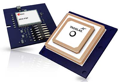
Tallysman, www.tallysman.com
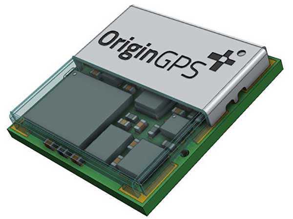
L1 + L5 chip
Suitable for IoT and auto OBD
Photo: OriginGPS
The ORG4600-B01, OriginGPS’ first dual-frequency GNSS module, is supported by the BCM47758 chip, enabling ultra-accurate GNSS positioning. It was developed for solutions requiring super-precision GNSS and a dual-frequency combination. The module enables customers to build solutions with sub-1-meter accuracy without implementing external components. Measuring 10 x 10 millimeters, the ORG4600-B01 supports L1 + L5 GNSS reception with one RF port, enabling use of a low-cost, dual-band antenna delivering sub-1-meter accuracy performance in real-world conditions. An alternate build option allows for separate L1/L5 RF outputs when dual antennas are required. The module is suitable for solutions requiring ultra-accurate positioning, such as telematics, the internet of things (IoT) and auto OBD applications.
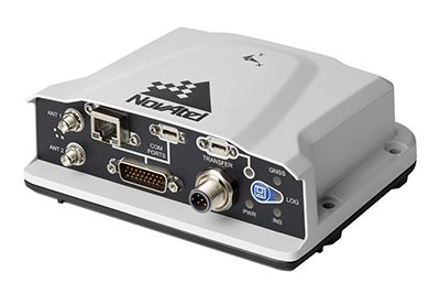
The PwrPak7-E2 contains an advanced Epson G370N MEMS inertial measurement unit (IMU) to deliver NovAtel SPAN technology in an integrated, single-box solution. It has a powerful OEM7 GNSS engine, built-in Wi-Fi, onboard NTRIP client and server support, and 16 GB of internal storage with higher performance and INS data rate. Connection options include serial, USB, CAN and Ethernet. Features include a 555-channel, all-constellation, multi-frequency positioning solution and multi-channel L-band that supports TerraStar correction services. It can be paired with an external receiver to support ALIGN GNSS azimuth aiding for low dynamic applications.
The MobileMapper 60 is a durable, efficient and accurate handheld device for geographic information system (GIS) and professional data-collection applications. The all-in-one GNSS receiver and smartphone offers 2-4 meter positioning accuracy in an all-weather design with a hand strap. It operates in extreme temperatures and rugged field conditions. It features a 6-inch high-resolution screen, large capacity all-day battery, Android 8.0 operating system and 2.2-GHz processor. Its 4 GB of memory and 64 GB of storage can manage large data sets with ease and speed. Bluetooth 4.1, 4G LTE and Wi-Fi capable, the MobileMapper 60 is suitable for cadastral, survey, topography and forestry.
Spectra Geospatial, spectrageospatial.com
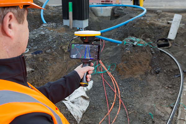
Outdoor AR
Enables visualization of 3D data
Photo: Trimble
The SiteVision outdoor augmented reality (AR) system enables users to visualize 2D and 3D data with cellular or internet connectivity for planning, collaboration and reporting. Combining hardware and software in an integrated, lightweight handheld or pole-mounted solution, users can view 3D models and assets in a real-world environment at a 1:1 scale, from any angle or position. SiteVision integrates a Trimble Catalyst DA1 antenna, electronic distance measurement (EDM) rangefinder and power management into a lightweight, handheld device that connects to a user-supplied Android mobile phone. The SiteVision subscription is available monthly or yearly, and combines Trimble’s high-accuracy positioning services and cloud-based processing technology to create a centimeter-accurate AR system. Users can visualize digital models from a wide range of data collection, design and constructible modeling tools in open industry-standard formats, including IFC and LandXML. For civil projects, SiteVision accurately visualizes data from Trimble’s Quantm, Business Center and Novapoint; design data from Civil 3D and Bentley OpenRoads; and GIS data from Esri ArcGIS software.
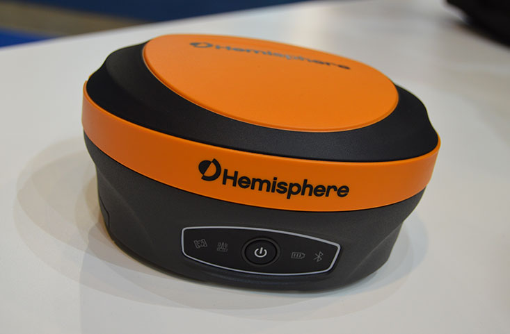
The S621, powered by the Phantom 40 GNSS OEM board, is a redesign of Hemisphere’s previous S321+. It processes and supports more than 800 channels with flexible and scalable simultaneous tracking of every modern and planned GNSS constellation and signal including GPS, GLONASS, BeiDou (including Phase 3), Galileo, QZSS, IRNSS, SBAS and Atlas L-band. The S621 combines Hemisphere’s Athena GNSS engine and Atlas L-band correction technologies with a new web user interface. It meets IP67 requirements and is immune to magnetic interference. It is designed for use in land or marine survey, GIS, mapping, construction or other applications requiring high-performance precision and positioning.
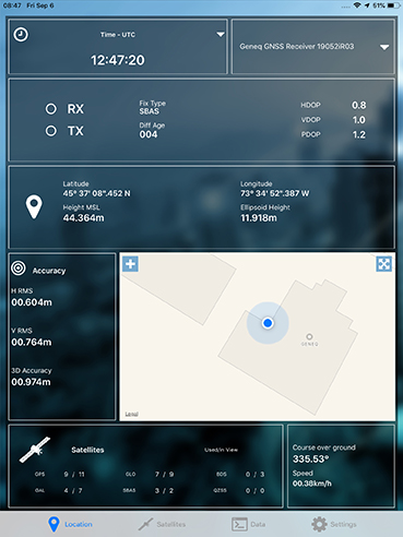
Records and transfers raw data for post processing
Photo: Geneq
The SXblue ToolBox is now available for iOS-compatible devices. The application was developed with special interest paid to raw data recording and NTRIP service connection. The Android application debuted in 2018. With the new iOS application, iPhone and iPad users can analyze the position data provided by the SXblue receiver, as well as location metadata. The application can record, save and transfer raw data from the GNSS receiver, thereby allowing post-processing activities. The application also acts as an NTRIP client, capable of connecting to an NTRIP server for real-time kinematic (RTK) corrections, and thus allows the receiver to issue very accurate location information. Receiver configuration is easy through the application, with the ability to set up and save user-defined commands for subsequent use. The settings include constellation to be used, differential source, NTRIP login credentials list and more.
TRANSPORTATION
Telematics for Ford
Simplifies mixed-fleet management
Photo: Ford
The Geotab Integrated Solution for Ford Vehicles integrates Ford vehicle data into the MyGeotab platform to give fleet managers a dedicated portal to process data. Ford Data Services securely transfers data from Ford vehicles with a factory installed or plug-in modem to Geotab’s cloud environment. It provides access to the Geotab Marketplace, a portfolio of mobile apps, hardware add-ons and software add-ins.
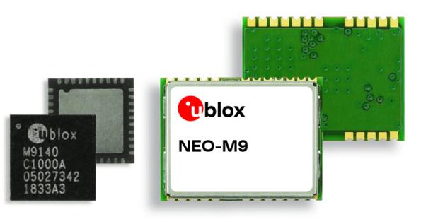
The M9 platform is designed for demanding automotive, telematics and UAV applications. With the u-blox UBX-M9140 GNSS chip, the M9 technology platform and the NEO-M9N (the first module based on the platform) can receive signals from GPS, GLONASS, BeiDou and Galileo concurrently. It can achieve high positional accuracy in difficult conditions such as deep urban canyons. The M9 offers a position update rate of up to 25 Hz, enabling dynamic applications to receive position information with low latency and has special filtering against RF interference, jamming and spoofing. U-blox also provides Explorer Kit M9 (XPLR-M9) for developers.
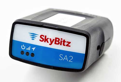
The SA2012 GPS tracker is equipped with the latest 4G LTE with 3G fallback. It is designed for customers looking for a scalable vehicle telematics solution. The hardware can be installed using the SkyBitz Ops Center mobile device, either directly plugging it into the vehicle diagnostic port or covertly installing it behind the dashboard. Once installed, the device feeds into the Ops Center platform, where users can manage the new device and others via a single interface. Coverage is across North America.
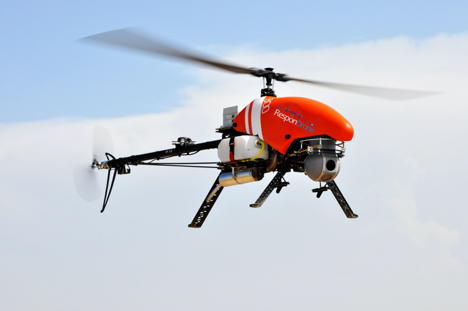
Emergency response providers participating in a Design Thinking workshop organized by the ResponDrone Project have indicated that they would like to use drones to gather and distribute crucial information and provide communication networks in disaster areas.
Preliminary results from the workshop, held in Thessaloniki, Greece, in November, indicate that first responders view the constant provision of real-time information in crisis situations as one of the most valuable benefits arising from using drones in disaster management missions.
The results of the Design Thinking workshop will be presented and discussed with the ResponDrone consortium at the project’s General Assembly, which will take place on Dec. 10–12 in Paris.
ResponDrone is an international project co-funded by the EU and the Korean government, which aims to develop an integrated solution for first responders to easily operate a fleet of drones for multiple synchronized missions to enhance their situation assessment capacity and their own protection.
The workshop, attended by representatives from first-responder organizations and industry partners of the ResponDrone consortium, took place to assess the best possible system requirements.
The aim of the ResponDrone project is to develop and evaluate a situation awareness system for first responders in emergency situations. The system will provide crucial information and communication services to all relevant stakeholders in a disaster situation.
First responders said they would like the ResponDrone system to:
provide reliable and validated real-time information
be flexible and open to information from already existing data sources
be able to visualize different information layers in a customizable manner
be fast and easy to deploy
be able to provide near future predictions regarding the development of the disaster situation.
Workshop participants included regional and national authorities in charge of first response, state agencies responsible for carrying out on the ground first response actions, rescue services and fire departments from Greece, France, Armenia, The Netherlands, Latvia, Bulgaria and Israel.
According to the first responders, a disaster can initially be described as a black box, which needs to be opened. Gathering relevant and reliable information from the disaster area and combining it with already available data, as well as rapid distribution of information to all relevant stakeholders, are the top priorities in disaster management.
The deployment of drones as a means of enabling the afore-mentioned capabilities seems to be a promising approach. It is crucial that the data gathered by drones is presented to the right people as soon as possible, preferably in real time.
“The workshop clearly showed the urgent need for the constant provision of real time information,” said ResponDrone project coordinator Max Friedrich from the German Aerospace Center (DLR).
“First responders wish to receive real-time data on current occurrences in the disaster area, on the position and status of potential victims and the first response units deployed in field, as well as the status and current location of available resources.”
Friedrich added that the ResponDrone system would be designed to provide highly accurate real-time information. The flexible system would gather information from various data sources and should be designed for fast and easy deployment.
ResponDrone has already begun developing an integrated solution for first responders to easily operate a fleet of drones with multiple synchronized missions to enhance their situation assessment capacity and their own protection. This system of systems will simplify and accelerate situation assessment and sharing, decision making and operations management, while requiring only a small crew to operate it.
GE Aviation and Hybrid Project team to provide commercial high-endurance vertical takeoff and landing (VTOL) UAV, with Auterion and GE Aviation providing comprehensive integration of ground, cloud and airborne components
GE Aviation has teamed with Hybrid Project to provide a VTOL UAV designed for high-endurance commercial applications at scale. Flight testing is underway, with commercial availability targeted for the first quarter of 2020.
The agreement enables Hybrid Project’s 35-pound hybrid-powered SuperVolo VTOL UAV with a full stack airborne computing hardware platform, flight and safety management, and integration from GE Aviation and Auterion.
GE Aviation’s computing platform enables flight control and airborne computing power at the edge while maintaining an independent and authoritative safety controller. Auterion’s Enterprise PX4 operating system resides on the vehicle, in the cloud, and the ground station.
The integration is the result of an agreement announced earlier this year between GE Aviation and Auterion to provide all-in-one hardware and software platform for commercial drones.
“The combination of Hybrid Project’s SuperVolo airframe, GE Aviation’s computing platform, and Auterion’s software stack enables an all-in-one solution that readily scales for commercial applications,” said Matt Vacanti, product leader, Avionics Systems for GE Aviation. “A highly integrated system is critical to achieving scalable commercial UAV operations.”
Hybrid Project’s SuperVolo has been designed from the ground up with an emphasis on endurance flight, ease of maintenance, and modularity. The combined system is comprised of technologies and services which have the capability to enable commercial operations in complex environments while meeting regulatory and mission outcomes.
“This collaboration, and the combined solution, will increase commercial operator flexibility, efficiency, and overall performance to a level not previously available in its class,” said Ryan Pope, co-founder of Hybrid Project.
Auterion’s Enterprise PX4 software is built on top of open software standards that are supported by a global developer community. Auterion’s enterprise software also provides the infrastructure enabling online workflows, compliance monitoring, and enterprise fleet management. “With Auterion software, the Hybrid Project SuperVolo flies farther, safer, and more efficiently, unlocking new BVLOS capabilities and missions that were previously not possible before commercial drones of this class were available,” said Kevin Sartori, co-founder of Auterion.
Skyward has updated its InFlight mobile ground control system app. It now offers operation planning and mobile LAANC requests.
In October, Skyward released a major update to its airspace intelligence map on both web and mobile platforms. The update included a new airspace design, clear LAANC grids, and a redesigned user experience.
It also integrated essential ground intelligence, including information on transmission lines, pedestrian walking paths, and 1 million vertical obstacles, as well as 3D views of key structures.
The new features announced this month include the ability to create and plan flights from mobile device. Users can now plan flight areas, check airspace and deploy without leaving InFlight, directly from the airspace intelligence map.
Users can now also make LAANC requests in the field to give users faster, greater access to controlled airspace. With LAANC, users can request access to airspace around airports and receive authorizations in near real time.
The funding enables continuation of a national effort by state government geospatial information officers and coordinators to work with other state agencies, local elections officials and state elections offices, national GIS (geographic information system) and elections organizations, and federal partners to identify opportunities to leverage this powerful technology to strengthen elections management and citizen engagement.
“As an organization made up of GIS leaders in state government, NSGIC is uniquely positioned to leverage the innovative work of states to use GIS for elections data,” said Molly Schar, NSGIC executive director. “We have enlisted those innovators to contribute and advise throughout the project. Collaboration has been key to the success of the project. Relationships built in the first phase of the project will be invaluable to the work of the second phase as the project seeks to increase engagement and, ultimately, impact.”
Two more years. The Geo-Enabled Elections project was launched in October 2017 and will now continue for an additional two years. The project aims to help strengthen electoral systems by supporting states in the adoption of GIS.
In practical terms, this means encouraging state governments to replace non-spatial address-file systems with election precinct and voter data in a GIS format, leveraging that format’s inherent visual and analytical advantages.
With its second phase, the project turns to focus on working hands-on with up to 10 more states through the pilot program, developing a curriculum for elections officials on foundations of GIS in elections, increasing awareness of the benefits of geo-enabling elections systems among elections stakeholders, and developing policy guidance and advocacy tools to support integration of GIS in elections.
“Accurate boundary lines and efficient voter placement are the building blocks of our elections and are tantamount to the integrity of the democratic process,” said Tammy Patrick, senior advisor at Democracy Fund Voice. “Democracy Fund Voice is a proud sponsor of efforts such as NSGIC Geo-Enabled Elections as a way to further ensure that the American electorate is well served.”
A report of the work done in the first phase of the project is now available.
Accomplishments in the first two years include:
developing an inventory of state implementations of GIS-based elections systems
giving workshops and presentations at national conferences
publishing detailed reports sharing the state of GIS in elections from the perspective of election officials and state GIS leaders
five pilot and case studies
development of a best-practices guide (both in detail and brief versions) was developed
Also, an inaugural Elections GeoSummit in August convened stakeholders from the national, state, and local levels to discuss best practices for geo-enabling elections in the United States.
These documents and other important resources can be found in a PDF format on the NSGIC website.