Telecom, technology and aviation industry leaders join forces to create the HAPS Alliance to connect more people, places and things by using the stratosphere
A group of global industry leaders is forming the HAPS Alliance, an association of world-leading telecommunications, technology, aviation and aerospace companies united in promoting the use of high-altitude vehicles in the Earth’s stratosphere to eliminate the digital divide and bring connectivity to more people, places and things worldwide.
Members who have committed to join the HAPS Alliance include
SoftBank Corp.’s HAPSMobile Inc.
Alphabet’s Loon LLC
AeroVironment Inc.
Airbus Defence and Space
Bharti Airtel Limited
China Telecom Corporation Limited
Deutsche Telekom AG
Intelsat US LLC
Nokia Corporation
SoftBank Corp.
Telefónica S.A.
Telefonaktiebolaget LM Ericsson
The HAPS Alliance is being created so member companies can
collectively advocate for High Altitude Platform Station (HAPS) business development with the relevant authorities in various countries
build a cooperative HAPS ecosystem
develop common product specifications and promote the standardization of HAPS network interoperability
All of these activities will be key to the Alliance’s aim of addressing diverse social issues and creating new value by providing telecommunications network connectivity worldwide through the utilization of high altitude vehicles.
Polar stratospheric clouds. (Photo: Paul Newman, GSFC/NASA)
The Alliance, originally an initiative from HAPSMobile and Loon, will have members from participating leading companies across the aerospace, technology and telecom industries to carry out the Alliance’s activities.
The launch of the HAPS Alliance follows an April 2019 announcement between HAPSMobile and Loon where the companies formed a strategic alliance to advance the use of high-altitude vehicles.
High-altitude network connectivity platforms operate in the stratosphere — above ground infrastructure but below satellites — allowing for near ubiquitous coverage that avoids ground clutter and significant latency issues.
These advantages make such vehicles a promising solution for expanding mobile coverage to areas where connectivity is lacking — mountainous terrain, remote islands, marine regions and developing countries — as well as for IoT and 5G use-cases. The HAPS Alliance seeks to create an ecosystem to support next-generation global connectivity needed to revolutionize the world’s mobile networks.
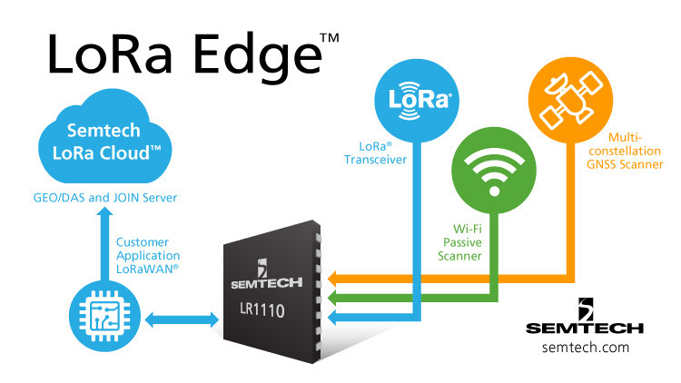
Semtech Corporation, supplier of high-performance analog and mixed-signal semiconductors and advanced algorithms, has launched LoRa Edge, a versatile and low-power software defined LoRa-based platform.
Semtech said LoRa Edge will enable a wide portfolio of applications for indoor and outdoor asset management, targeting industrial, building, home, agriculture, transportation and logistics markets.
The first product from this portfolio is a geolocation solution for development of internet of things (IoT) devices for asset management applications. It features low-power Wi-Fi and GNSS sniffing capabilities combined with LoRa Cloud geolocation and device management services to significantly reduce the cost and complexity of locating and monitoring IoT assets.
“Semtech continually delivers internet of things (IoT) solutions that simplify and accelerate the development of LPWAN applications,” said Pedro Pachuca, director of IoT Wireless in Semtech’s Wireless and Sensing Products Group. “LoRa Edge and LoRa Cloud geolocation services enable customers to develop ultra-low power applications for a variety of industries and will expand the mass adoption of LoRa in the IoT ecosystem.”
Over the next decade, 500 billion devices are expected to connect to the internet (according to Cisco), as organizations continue to shift towards a more IoT-focused business strategy, and the majority of those IoT devices require some form of localization capability either at point of install or through the assets life.
The LoRa Edge geolocation platform will enable solution providers to leverage the unique localization capabilities of LoRa as well as GNSS and Wi-Fi scanning capabilities from a single chip solution, allowing customers to choose the best localization tool for the application task they are addressing.
By removing the need for incremental GNSS and Wi-Fi components, LoRa Edge reduces the bill of material (BOM) costs of devices and significantly reduces design and procurement complexity, Semtech said.
The first LoRa Edge chipset targeted with geolocation (LR1110) is available today; more products from this portfolio will be released in the first half of this year.
Product Features
Multi-Purpose Radio Front-End
150 – 2700 MHz continuous frequency synthesizer range
GPS/BeiDou scanning
Wi-Fi passive scanning
Low-Power LoRa/(G)FSK RF Transceiver
Worldwide frequency bands support in the range 150 – 960 MHz
High power PA path +22 dBm
High efficiency PA path +15 dBm
Fully compatible with the LoRaWAN standard
Cryptographic Engine
Hardware support for AES-128 encryption/decryption based algorithms
Handling device parameters such as DevEUI and JoinEUI
Protects confidential information such as encryption keys
Stores NwkKey, AppKey, as defined in the LoRaWAN standard
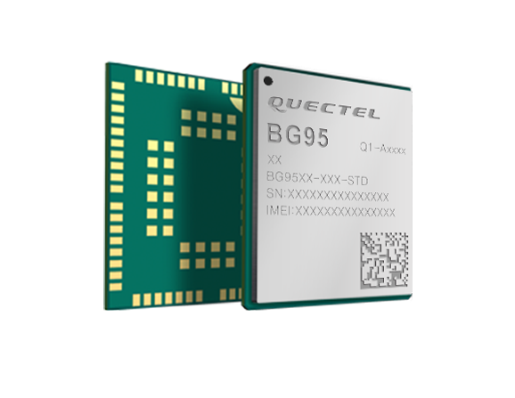
Quectel Wireless Solutions is collaborating with Microsoft and Qualcomm Technologies to integrate its new LPWA module BG95 with Microsoft’s Azure Device SDK.
The integration will provide direct and secure connections to Azure IoT Hub and provide full support for Azure device management capabilities.
Targeting global markets, the BG95 module is a cost-optimized, highly-integrated variant supporting integrated GNSS, Cat M1, Cat NB2 and EGPRS (also called EDGE). The module complies with 3GPP Release 14 and delivers improved capabilities in power consumption, data rates and hardware-based security.
The BG95 cellular module is based on the Qualcomm 9205 LTE modem, to be integrated with Microsoft’s Azure Device software development kit (SDK). As a result, customers can connect their BG95 devices to the Microsoft Azure cloud where they can build, manage and deploy internet of things (IoT) solutions at scale, significantly accelerating time to market.
By integrating RAM/flash, an ARM Cortex A7 processor supporting ThreadX, the BG95 is engineered to reduce power consumption significantly in idle mode.
By doing this, the BG95 has the potential to support decade-plus battery life, which is critical for IoT devices serving long life spans, such as asset trackers, smart meters, smart city sensors, home security and wearable trackers.
Additionally, Azure IoT is built for security. It simplifies the complexity of IoT security solutions with built-in protection at each stage of deployment (including cloud services and devices) and minimizes security weaknesses wherever they exist. Leveraging Azure IoT security features, Quectel BG95 will offer IoT devices end-to-end security capability in order to prevent potential risks.
“We’re excited for the Azure edge device ecosystem to continue to grow. Our partnership with Quectel and Qualcomm Technologies will deliver what our customers need — bringing together ultra-low power cellular modules and Azure to drive their digital transformation,” said Roanne Sones, corporate vice president at Microsoft.
“The BG95 module is the first Qualcomm 9205 platform to support IoT Plug and Play, accelerating LPWAN solution deployments like smart meters and asset trackers that connect seamlessly to our IoT Central offering,” Sones said.
“With its cutting-edge performance and power-saving capabilities, the Qualcomm 9205 LTE Modem is the gold standard for multimode IoT modules looking to offer NB-IoT, Cat-M1, GPRS, and GNSS connectivity,” said Jeffery Torrance, vice president, business development, Qualcomm Technologies, Inc. “We are proud to continue our long-standing collaboration with Quectel to jointly drive the IoT forward.”
“We are happy that the BG95-M3 has been verified on Microsoft Azure IoT Plug and Play. This validates our ability to jumpstart customers’ IoT projects with pre-tested modules and operating system combinations. Leveraging our close relationship with Microsoft and Qualcomm Technologies, we will jointly provide more integral ‘Device-Cloud’ solutions to customers,” said Doron Zhang, Chief Operation Officer, Quectel. “As one of the first wave Azure IoT PnP partners, Quectel has worked with Microsoft on LTE Mobile Broadband (MBB) modules, which have been widely adopted by top laptop OEMs. In the future, we will extend the partnership to more fields, such as Artificial Intelligence (AI) and Intelligent Edge, in order to help the Microsoft partner ecosystem connect their devices even more intelligently.”
Our nation’s sewers are under critical examination now more than any other time in history. The act of collecting sewage and stormwater, transporting it to the treatment system, and processing waste is no doubt a feat of science and engineering that we take for granted in the developed world.
Sewer infrastructure is a critical public asset whose importance in modern life cannot be overestimated, and to keep things running properly takes round-the-clock maintenance and operations. It’s only when the system fails or floods that we fully appreciate our dependence on it.
At last count, there are at least 16,000 publicly owned wastewater treatment systems (also called Publicly Owned Treatment Works, or POTWs) in the United States, providing sewer service for more than 245 million people. Additionally, about 860 communities have combined sewer systems (CSS) that serve about 40 million people.
These CSS capture both sewage and stormwater before the combined mixture is treated and either reused, recycled or discharged to the environment. In wet weather events, untreated waste and stormwater can escape capture due to overfilled combined storm sewers, known as combined sewer overflow (CSO). These CSO events can spill sewage into rivers and streams, creating a major source of water pollution across the country.
To make matters even more complicated, the effects of climate change and increased rainfall in some areas have created new challenges to our nation’s sewer infrastructure.
Additionally, federal and state regulations like those for municipal separate storm sewer systems (MS4) that discharge untreated runoff into the environment have added new demands of our publicly owned entities that manage these systems.
A map of the continental U.S. depicting POTWs, from the EPA Facility Registry Service’s Wastewater Treatment Plants Dataset. (Image: CivicMapper)
The impact of sewer overflow is especially felt in the eastern United States where the combination of aging infrastructure and increasingly frequent and severe rainfall events have presented significant challenges in the capture, handling and treatment of sewage.
With some eastern cities receiving record rainfall in the past few years, it’s now more important than ever to understand our sewer infrastructure, including: where it is, who is responsible for it, when it was installed, how it is networked, and what are its defining characteristics. These data are essential for performing maintenance, for planning growth, and for undertaking new construction projects. The need for better understanding, visualizations, and communication of sewer data assets is a perfect use case for Geographic Information Systems.
The Case for Mapping Sewer Networks
There are many moving parts to a sewer network. Representing each manhole, sewer line, pump station, inlet, and outlet within a unified map requires expertise in the art and science of mapping. Spatial data from a breadth of sources like engineering drawings, as-builts, CAD datasets, spreadsheets, field surveys, sewer cameras, flow meters, and aerial imaging have traditionally been the go-to datasets for constraining the topology, attributes, and capacities of sewer networks. Additionally, new kinds of data procured from emerging geospatially-enabled technologies like subsurface robotic pipe inspections and simultaneous localization and mapping (SLAM) provide a glimpse of where sewer map data will come from in the future. For POTWs and their stakeholders, information from both old and new sources can synergistically come together in a GIS as part of a greater asset management program.
Creating a unified map of sewer infrastructure from many data sources requires time and effort to construct proper geospatial data topology, correct directionality, and accurate attributes. These undertakings are greatly supported by the development of data models, workflows, tool sets, metadata, and documentation that will make it easier for workers to maintain sewer data now and in the future. The added bonus of developing these data for use in a GIS is a highly valuable and functional data asset that can be used to inform operational and business processes at every level of the organization.
An organization’s data represents the outcomes of some of the mostly costly investments and operational endeavors undertaken by that entity. When big or important projects are completed, it is the data collected during the work that lives on after staff turnover and retirements. With respect to mapping sewers, many POTWs already have much of the data they need to put into a mapping system, whether it be in a CAD file, on paper, or living in a spreadsheet. GIS liberates these data so that it becomes a living product and enables them to be leveraged in powerful ways and across multiple operational areas.
Implementing a sewer GIS increases the return on investment of data, creates a platform for data sharing across other systems, and sets the stage for innovation and efficiency improvements.
While creating and maintaining a sewer GIS might sound like a big-ticket item, modern mapping tools are making it more cost effective than ever before. Competitively priced software licensing, open-source GIS technologies, cloud computing, and in-browser processing can lower the costs of geospatial application development. Further, establishing geospatial data pipelines and application programming interfaces (APIs) can reduce the time needed to condition data before they are ingested into mapping systems and across multiple software platforms.
Taking sewer GIS to the next level with network tracing
One of the most exciting applications of a sewer GIS is the capability to perform network tracing. These traces can show the locations and direction of wastewater flow from any point within the system and are commonly performed by POTW engineering personnel. The ability to perform a sewer network trace within a GIS is valuable for several reasons.
An example of a network trace map. (Image: CivicMapper)
The trace helps operators and engineers better visualize the contributing sources to main sewers that collect wastewater from the many lateral and branch sewers that service buildings, businesses, and homes. Enabling this capability in a GIS environment makes it more accessible to other personnel, and especially those working on site. Allowing POTW easier access to network tracing through a GIS helps teams across the organization stay informed on what addresses are connected to which sewer mains, facilitating better communication and collaboration on maintenance and expansion projects.
The network trace can operate upstream to locate which buildings might be contributing to problems downstream. From any manhole or service location, the sources of industrial or commercial waste violations or exceedances can be better identified through upstream sewer tracing. The ability to query any point along the sewer network and constrain the sewershed from that point saves time and resources of field personnel when diagnosing problems and finding solutions.
Sewer systems are vital, publicly funded resources yet most people know very little about the way their homes and businesses connect to this system. Inviting the public to view a unified and continuous map that represents their sewer network is a great learning resource and facilitates increased awareness and familiarity with the work of the POTW.
Once such example is the Flush-It web application. This app allows the public to interact with an engaging map that shows the path their flush takes on its way to the treatment facility. The tool was built on open source geospatial technology and uses a unified, topologically correct sewer data set as the backbone of the network trace. Applications like these are also great for educating students on the importance of science and engineering on daily life.
The Flush-It web application, built on a sewer network GIS dataset. (Image: CivicMapper)
The process of building a GIS of networked sewer map from a set of historic and disparate set of data sources might seem daunting for many POTWs, but the benefits of doing so profoundly outweigh the headaches.
This type of mapping system saves time and money in the long run by ensuring that the best and most current data are shared across multiple operational units and opens up new pathways for innovation and outreach.
As cities continue facing the complications of aging infrastructure and a changing climate, there is no better time than the present to modernize sewer data and use this amazing data resource to both protect communities and equip them with the information needed to tackle future challenges.
Emily Constantine Mercurio is the CEO and co-founder of CivicMapper. Emily grew up in Pennsylvania’s coal country, and at a young age became interested in geoscience, maps, and the interplay of nature and human activity. Her career has centered on creating innovative, data-driven, and tangible solutions to support decisions at the intersection of our natural and built environments. She leverages more than 25 years of experience with Earth science data and geospatial technologies for leading the development of CivicMapper’s products and services. Emily has a Ph.D. in Geology and is a licensed professional geologist.
Earlier this month, Apple applied to the Federal Communications Commission for to a license to install GPS testing equipment on its headquarters campus.
This may be related to an application filed by Apple Inc. with the U.S. Patent Office in August 2019, which describes the company’s “Machine Learning Assisted Satellite Based Positioning.”
From the patent application:
MACHINE LEARNING ASSISTED SATELLITE BASED POSITIONING
A device implementing a system for estimating device location includes at least one processor configured to receive an estimated position based on a positioning system comprising a Global Navigation Satellite System (GNSS) satellite, and receive a set of parameters associated with the estimated position.
The processor is further configured to apply the set of parameters and the estimated position to a machine learning model, the machine learning model having been trained based at least on a position of a receiving device relative to the GNSS satellite.
The processor is further configured to provide the estimated position and an output of the machine learning model to a Kalman filter, and provide an estimated device location based on an output of the Kalman filter.
In 2015, Apple acquired the small enhanced-GPS company Coherent to aid the speed and accuracy of its devices’ location services. Presumably, Apple intends to incorporate its machine-learning positioning method into its navigation software.
The Federal Aviation Administration (FAA) and Association for Unmanned Vehicle Systems International (AUVSI) will co-host the 5th Annual FAA Unmanned Aircraft Systems (UAS) Symposium June 16-18 in Baltimore. The event will take place at the Baltimore Convention Center.
The symposium will bring together representatives from the FAA, other government agencies, the industry and academia. According to the show organizers, the presenters and panelists will discuss the latest information and advancements related to the diverse uses of unmanned aircraft, and how these new entrants are being safely integrated into the National Airspace System.
The show will include four primary educational tracks, including public safety, technology and innovation, international and policy. The public safety track will explore topics such as addressing community concerns, security, and using drones to conduct safer and more effective public safety missions. The technology and innovation track will cover how drones and drone technologies are innovating rapidly and fundamentally changing aviation. The international track will feature discussions on how national and international UAS experts, industry representatives, civil society stakeholders, non-governmental organizations and policy makers are working to integrate and use drones across the globe. Finally, the policy track will allow attendees to hear directly from policy decision makers and get their thoughts on regulatory, operational and technical concerns.
In addition, the FAA will operate as an on-site resource center to answer questions from UAS owners and operators. Subject matter experts will be on hand to answer questions about airspace authorizations, waivers, the Part 107 small UAS rule, changes in hobbyists’ drone operations, the Remote Identification rulemaking, and other policies and regulations, the organizers added.
Duncan Guthrie (left) of 1Spatial and Peter Russell of Neueda. (Photo: 1Spatial)
1Spatial has formed a strategic partnership with international technology company Neueda. 1Spatial and Neueda will jointly provide digital solutions that enable customers to transform and improve the way they do business.
1Spatial is a software solutions provider and global expert in managing location and geospatial data.
Neueda provides digital transformation services to customers in the private sector, public sector and capital markets across the globe. Headquartered in Belfast, Neueda has bases in Dublin, London, Malaga and New York.
As a software solutions provider and global experts in managing location and geospatial data, 1Spatial will complement Neueda’s services by provisioning geospatial digital services that support customer transformation and improvement projects.
“We are excited to announce this partnership with Neueda and really look forward to working together with their highly talented specialists,” said Duncan Guthrie, managing director, 1Spatial. “We both have a similar approach with our customers and always ensure we deliver the best solutions to meet their business needs. Through this partnership we look forward to delivering success for our customers and helping them unlock the value of their spatial data.”
“We are delighted to formally partner with 1Spatial and look forward to working with a global leader in geospatial data,” said Peter Russell, managing director, Enterprise Services, Neueda. “Neueda sees data as a key enabler to true digital transformation and geospatial data is certainly a key challenge for many of our customers. We hope this partnership will also allow us to develop joint propositions to break into new markets.”
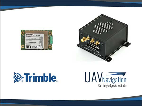
UAV Navigation’s flight control solutions for remotely piloted air systems/unmanned aerial vehicles (RPAS/UAVs) are compatible with the Trimble UAS1 high-precision GNSS receiver. The core benefits of Trimble’s GNSS solution include centimeter-level precision and easy integration.
Image: UAV Navigation and Trimble
The light, small Trimble UAS1 receiver is less vulnerable to vibrations or temperature fluctuations, making it suitable for UAVs and RPAS. In addition, the receiver can provide real-time kinematic (RTK) positioning using a base station, enabling users to achieve higher precision for their projects.
Most UAV missions demand precision in its subsystems. The Trimble UAS1 receiver meets these requirements and includes a 336-channel high-precision GNSS engine. It tracks L1/L2 frequencies from the GPS, GLONASS, Galileo and BeiDou constellations.
The Trimble UAS1 supports OmniSTAR and Trimble CenterPoint RTX GNSS corrections, which enable precise and robust positioning without the use of a base station via a subscription service. The receiver also offers an industry-standard camera hot-shoe interface and a wide DC voltage range to work in a broad range of UAVs.
While Trimble is highly specialized in providing advanced GNSS solutions, UAV Navigation’s focus is on innovations in flight control systems. With this combined technology, current UAV/RPAS systems can now operate in more demanding environments and deliver higher precision through better navigation, UAV Navigation stated in a press release.
Septentrio’s new web shop offers direct access to mosaic multi-frequency GNSS receiver module. Customers can purchase the mosaic development kit quickly and easily to evaluate this unique module.
Septentrio has opened an online store shop.septentrio.com, selling high-performance GPS/GNSS module receivers. The web shop is accessible via the Septentrio website, offering customers multi-constellation multi-frequency GNSS technology, which provides reliable centimeter level positions suitable for demanding applications.
The first product available for sale online is mosaic, Septentrio’s most compact GNSS receiver module. This light-weight, low-power receiver brings robust high-accuracy positioning to the mass market. With its security-centered anti-jamming and anti-spoofing technology, mosaic provides positioning to numerous demanding applications such as automotive ADAS, logistics automation, and robotics.
“We see a growing demand for reliable high-accuracy positioning across various industries. As GNSS receivers move towards becoming a commodity, we are providing our customers with easier and faster access to GNSS technology,” said Francois Freulon, senior product manager, Septentrio. “We are happy to offer the mosaic development kit as the first product in the shop, which makes it easy for people to purchase and evaluate the mosaic module and discover its capabilities for delivering robust, highly-accurate positions. “
True multi-frequency multi-constellation technology of mosaic ensures access to every possible signal from all available GNSS constellations including the U.S. GPS, European Galileo, Russian GLONASS, Chinese BeiDou and Japanese QZSS satellites. Septentrio’s advanced field-proven algorithms exploit this signal diversity to deliver maximum positioning availability even in the most difficult environments such as under foliage or in urban areas.
GNSS signals can become jammed by nearby electronics or illegal jammers that emit radio signals interfering with GNSS. Mosaic uses jamming-resistant signal processing making it robust against interference. Its design focuses on continuous, reliable high-accuracy positioning making mosaic suitable for demanding applications such as ADAS, UAVs and industrial automation.
“With due regard to the safe and healthy environment in Barcelona and the host country today, the GSMA has cancelled MWC Barcelona 2020 because the global concern regarding the coronavirus outbreak, travel concern and other circumstances, make it impossible for the GSMA to hold the event,” said GSMA CEO John Hoffman in a statement. “The host city parties respect and understand this decision. The GSMA and the host city parties will continue to be working in unison and supporting each other for MWC Barcelona 2021 and future editions. Our sympathies at this time are with those affected in China, and all around the world.”
GSMA, which organizes Mobile World Congress, represent the interests of mobile operators worldwide, uniting more than 750 operators and nearly 400 companies in the broader mobile ecosystem, including handset and device makers, software companies, equipment providers and internet companies.
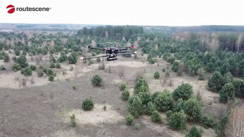
Professor Tom Scott, from the School of Physics at the University of Bristol, U.K., led a group of researchers from NCNR to conduct surveys on multiple sites of interest, including the Buriakivka village, a settlement abandoned following contamination from the power plant accident, and the “Red Forest,” a natural woodland area located the closest to the reactor.
Working closely with local Ukrainian authorities, the team operated unmanned aerial vehicles (UAVs) — Routescene’s LidarPods flown on DJI M600 hexacopter drones — to perform a series of radiation mapping surveys over the course of 10 days.
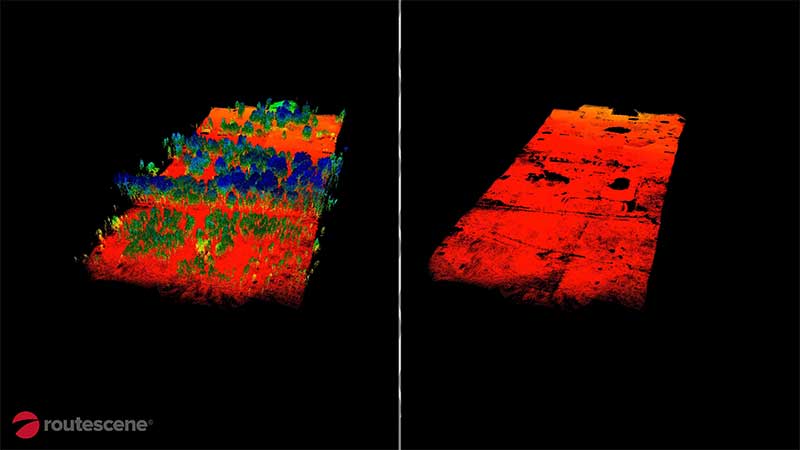
According to Routescene, the point cloud data collected was processing using its LidarViewer Pro software to generate a detailed digital terrain model. It was then overlaid with the results from a gamma spectrometer survey, undertaken to measure radiation intensity, to locate the exact sites of the radiation hotspots.
“The algorithm converts the aerial radiation intensity recorded by a UAV survey into a ground intensity map,” said Kieran Wood, senior research associate at the University of Bristol. “This process is heavily affected by the distance between the airborne radiation sensor and the ground/buildings. Hence, high accuracy lidar-based models were essential.”
Photo: Routescene
Results
While the general widespread radiation contamination in the Red Forest was already known, the results revealed that the radioactivity was unevenly disturbed. Although radiation intensity had reduced in some areas, other areas remain highly contaminated confirming continued danger to anyone accessing those areas, Routescene reported.
In addition, the researchers detected one unexpected hotspot in the ruins of a facility that was used to separate contaminated waste during clean-up efforts immediately after the accident.
This expedition was the first in a series of surveys NCNR will conduct in Ukraine over the next year. The new maps will help officials prevent risks to visitors to the area and the full results will be published soon, Routescene said.
Xag is setting up a 5-million-yuan fund on coronavirus response, calling for voluntary drone disinfection operations in China.
According to Xag, the 5-million-yuan fund is committed to providing Xag’s agricultural drone users with technical support to properly carry out aerial disinfectant sprays that help curb the spread of virus, especially in rural villages with weaker health system and poorer sanitation condition.
Operations will target densely populated outdoor public places and those communities having confirmed or suspected cases of coronavirus, the company added. Another focus of the initiative is to clean and disinfect medical and epidemic prevention vehicles moving between affected and unaffected areas.
According to Xag, it will cover all the spare parts and maintenance expenses for those who voluntarily engage, and disinfection actions would be taken under the permission of Centre for Disease Control and Prevention and relevant government authorities.