Pointfuse has developed smart software that automates the identification and classification of objects for facilities management applications using data from mobile mapping systems like the new Leica BLK2GO.
Pointfuse software converts the millions of individual measurements captured by laser scanning and photogrammetry into useable 3D mesh models. The unique ability to classify objects within Pointfuse, both automatically and manually, has already had a huge impact on how as-built data is used within design and construction. It can now realize real time records for space utilization and optimization projects, reducing costs and speeding workflows within facilities management.
The Leica BLK2GO. (Photo: Leica Geosystems)
Pointfuse Simple BIM (sBIM) leverages the core functionality of Pointfuse — the segmented mesh model; automatically converting classified mesh models into “family” groups, such as walls, floors, doors, windows, etc. for use with popular downstream BIM and FM software. Pointfuse sBIM data can then be exported as IFC (Industry Foundation Class) parametrized objects and 2D floors plans and space management reports easily derived. Pointfuse sBIM also automatically calculates quantities, areas and dimensions in an easy to read PDF report.
“This ability to convert classified objects into family place holders has a huge impact on how as-built data is used within a Scan2BIM workflow with the potential for a real return on investment for facilities and space management applications,” said Mark Senior, regional sales director at Pointfuse. “The combination of ease and speed of data capture, as offered by modern hand-held indoor mapping systems like the newly launched Leica BLK2GO, with the automation of Pointfuse processing will release the potential of laser scanning across this sector.”
Pointfuse sBIM was developed in response to a large scale client opportunity that saw the scanning of millions of square feet of facilities with the final deployment of data in Archibus facilities management software using Autodesk Revit as a bridge. Early testing identified that 3D was as quick to create as traditional 2D workflows and exported data is in the region of hundreds of Kbs compared to the Gb volumes of the original point cloud. Taking the process one step further Pointfuse provides an accurate record of the as-built scene by allowing users to create Hybrid meshes combining Pointfuse models with the sBIM IFC container.
Pointfuse will be showcasing the sBIM functionality at the Autodesk University (AU) Expo which takes place Nov. 19-21 at the Sand Expo Convention Centre in Las Vegas, Nevada.
A link to the live event will be sent to you two hours before the event. Your personalized event URL will be automatically generated by the ON24 system. To ensure receipt of the email, please whitelist this email address by adding it to your contacts: [email protected].
This presentation will begin at 1 p.m. Eastern / 10 a.m. Pacific on Thursday, Dec. 12. A recording will also be sent to you the following day so you can watch it on-demand.
Audience members may arrive 15 minutes prior to live time. If you have any questions, please contact event producer Grace Rybak at [email protected].
“Seen & Heard” is a monthly feature of GPS World magazine, traveling the world to capture interesting and unusual news stories involving the GNSS/PNT industry.
Photo: i viewfinder/Shutterstock.com
It’s their land, too
Animal tracking is helping biologists see how many animals rely on wildlife crossings over or under highways. In the United States, specially designed crossings protect pronghorn antelope (Wyoming), panthers (Florida), mule deer (Nevada), moose (Utah) and grizzly and black bears (Montana), while crossings in Asia benefit rhinos, tigers and elephants. With crossings, mortality drop as much as 90%, says The Washington Post. In New Mexico, state agencies and tribes are tagging animals with GPS collars to identify roads that hinder migration. Meanwhile, engineers in Southern California are designing the world’s largest animal crossing, an $87 million overpass that will span a 10-lane Los Angeles freeway for the region’s mountain lions.
Tesla, come to me
Photo: Tesla
The new Tesla Smart Summon feature in Autopilot v10 autonomously drives the car to meet its owner, such as in a parking lot. Smart Summon has been used more than 550,000 times, Tesla CEO Elon Musk said on Twitter. But it has a few glitches: Owner tests have resulted in fender-benders, near crashes, ignored stop signs and a police run-in. And don’t test it with another Tesla nearby — the cars get confused.
Help, I’m shark bait!
Photo: European GNSS Agency
The Galileo Search and Rescue (SAR) service was demonstrated Sept. 26 off the coast of Belgium. In Operation Shark Bait, a volunteer “victim” — Australian broadcaster Tara Foster — operated her Galileo-enabled SAR beacon from a life raft off the port of Ostend. The service quickly triggered, with the rescue initiated in under four minutes.
Wheelchair navigation
A new app launched in Portsmouth, England, helps people with limited mobility plan their travel routes. The Route4U pavement navigation app benefits both wheelchair and pram (stroller) users, allowing them to discover safer, more accessible routes across the city. The app indicates pavement obstacles, surface quality, curb heights and widths, inclines and travel distances.
Which of several proposed terrestrial PNT technologies is best suited to complement and back up GPS?
Jules McNeff
“Seeking PNT resiliency for critical functions, a layered, multi-source terrestrial RF backup strategy could include eLoran for continental coverage and Locata, or similar system(s), for high-precision, localized service where needed. However, don’t forget feature-aided navigation using optical, radar, lidar, etc., and positioning/timing from ‘validated’ signals of opportunity in data-rich environments.” Jules McNeff
Overlook Systems Technologies
Terry Moore
“No single technology can provide a backup to GNSS to match the ubiquity of satellite-based PNT. However, placing inertial navigation systems at the core of our PNT solution, and focusing on bounding the growth of the positioning errors using whatever other space or terrestrial measurements are available, could provide an alternative paradigm to resilient positioning and navigation.” Terry Moore
University of Nottingham
Members of the EAB
Tony Agresta Nearmap
Miguel Amor Hexagon Positioning Intelligence
Thibault Bonnevie SBG Systems
Alison Brown NAVSYS Corporation
Ismael Colomina GeoNumerics
Clem Driscoll C.J. Driscoll & Associates
John Fischer Orolia
Ellen Hall Spirent Federal Systems
Jules McNeff Overlook Systems Technologies, Inc.
Terry Moore University of Nottingham
Bradford W. Parkinson Stanford Center for Position, Navigation and Time
Letter signed to advance role of geospatial knowledge infrastructure in global society and economy
Geospatial Media & Communications has signed a letter of cooperation with the United Nations Statistics Division (UNSD) to work together to advance the role of geospatial knowledge infrastructure in global society and economy.
Consistent with their respective mandates, the UNSD and Geospatial Media will collaborate to carry out activities related to their common objective of demonstrating the value of global geospatial knowledge, the data ecosystem, public-private partnerships, and their contribution towards building Geospatial Knowledge Infrastructure and the Global Development Agendas.
The agreement was signed by Stefan Schweinfest, director, UNSD, Department of Economic and Social Affairs, and Sanjay Kumar, CEO, Geospatial Media, in New York on Oct. 31.
“The United Nations 2030 Sustainable Development Agenda is ambitious and requires countries to have solid national information systems to successfully stir the process of implementation. It is a central task of my office, the United Nations Statistics Division, to support countries in building the necessary national information capacities, both in the area of statistics and geospatial information. For this challenging task we need the cooperation of the private sector through well established public-private partnerships. Geospatial Media & Communications is a unique partner in this respect, due to its global reach and its in-depth knowledge and understanding of country needs. I am, therefore, delighted to cooperate with them closely in the coming years,” said Mr. Schweinfest.
“Pursuing its vision to make a difference through geospatial knowledge in world economy nad society, Geospatial Media has been evangelizing geospatial industry globally for over two decades through research, advocacy, media and knowledge exchange platforms. It has contributed in the formation and strengthening of several institutions, including the Association of Geospatial Industries (AGI), World Geospatial Industry Council (WGIC), UNGGIM Private Sector Network and the National Think Tank on Geospatial Strategy for New India. Through this collaboration, our intent is to further our vision to showcase high level value of geospatial knowledge in global development agenda and facilitate alignment and evolution of geospatial stakeholders with emerging socio-economic development models in the fourth Industrial age,” said Mr. Sanjay Kumar.
The intended collaboration will focus on a number of common objectives at national, regional and global levels which will include:
Working together to create joint programs and projects to develop geospatial knowledge infrastructure, networks and human resource capacities;
Assessment of the prospective role of geospatial knowledge infrastructure in global society and economy;
Collaboratively developing broader methods, guidelines, architectures and policy frameworks for the adoption, utilisation and benefits of geospatial knowledge infrastructure;
Develop documents, training modules and other resources to assist National Geospatial Information Agencies in their transformation and modernization aspirations in alignment with the national to global vision of the Integrated Geospatial Information Framework;
Facilitate a collaborative knowledge exchange and engagement atmosphere between the commercial geospatial industry, national geospatial agencies, and the broader user industries and civil society, towards developing public-private partnership models for co-creating geospatial knowledge infrastructure and strengthening of industry and institutional capacities; and
Advocate, communicate and promote the value and utility of geospatial information and enabling technologies for sustainable development.
A link to the live event will be sent to you two hours before the event. Your personalized event URL will be automatically generated by the ON24 system. To ensure receipt of the email, please whitelist this email address by adding it to your contacts: [email protected].
This presentation will begin at 1 p.m. Eastern / 10 a.m. Pacific on Thursday, Nov. 21. A recording will also be sent to you the following day so you can watch it on-demand.
Audience members may arrive 15 minutes prior to live time. If you have any questions, please contact event producer Kelly Limpert at [email protected].
On Sept. 19, in conjunction with the ION GNSS+ conference, GPS World hosted its annual Leadership Awards dinner. Five honorees — chosen by a panel of GNSS experts — were recognized for their outstanding recent contribution or achievement in four categories: Satellites, Signals, Services and Products.
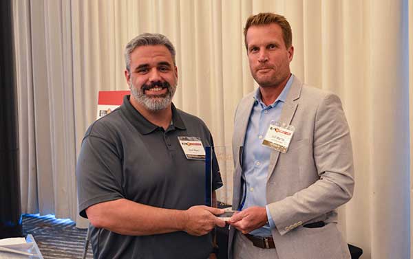
SATELLITES AWARD: Presented by Johnathan Caldwell (left) to Mark Crews, both of Lockheed Martin. Crews accepted on behalf of Tim Hartman. (Photo: GPS World)
Satellites Award
TIM HARTMAN: Satellites Award winner
Tim Hartman, Chief Engineer, Military Space Programs, Lockheed Martin
Hartman was recognized for serving as the program manager for GPS IIRM and GPS III Space Segments. Tim’s leadership and program dedication helped support the U.S. Air Force’s decision to declare GPS III ready for launch on Oct. 17, 2017.
On Aug. 22, Lockheed Martin Space celebrated the successful launch of the second of up to 32 next-generation GPS III/IIIF satellites that the U.S. Air Force contracted the company to design and build. Lockheed Martin’s commitment to positioning, navigation and timing can be found in the exemplary performance of the 18 Lockheed Martin-built GPS IIR and IIRM satellites that are a proud part of today’s 31-satellite GPS constellation. The company also is proud to support the Air Force with its continued sustainment of the current GPS Operational Control Segment.
SIGNALS AWARD: Presented by Joe Rolli of L3Harris (left) to Ramsey Faragher. (Photo: GPS World)
Signals Award
Ramsey Faragher, Founder and CEO, Focal Point Positioning
Focal Point Positioning’s new supercorrelator approach to indoor and urban GNSS signal processing could revolutionize smartphone-based GNSS. New signal processing methods for the correlation stage of a GNSS receiver enable several seconds of coherent integration while the receiver is undergoing dynamic motions. This improves accuracy and integrity, and provides anti-spoofing and spoofer-localization capabilities — without hardware changes or requiring access to encrypted signals.
L3Harris Technologies is an agile global aerospace and defense technology innovator, delivering end-to-end solutions that meet customers’ mission-critical needs. The company provides advanced defense and commercial technologies across air, land, sea, space and cyber domains. L3Harris has approximately $17 billion in annual revenue and 50,000 employees, with customers in 130 countries.
SERVICES AWARD: Presented by Mike Shepherd of Collins Aerospace (back) to Simon Banville (front left) and Denis Laurichesse. (Photo: GPS World)
Services Award
Denis Laurichesse, Navigation Systems Department Expert, Centre National d’Études Spatiales (CNES)
Simon Banville, Senior Geodetic Engineer, Natural Resources Canada (NRCan)
Laurichesse and Banville demonstrated instantaneous, centimeter-level, multi-frequency precise point positioning (PPP). Their work shows PPP might become, within a few years, a practical alternative to real-time kinematic (RTK) for a wide range of applications.
Collins Aerospace Systems, a unit of United Technologies Corp., is a leader in technologically advanced and intelligent solutions for the global aerospace and defense industry. Created in 2018 by bringing together UTC Aerospace Systems and Rockwell Collins, Collins Aerospace has the capabilities, comprehensive portfolio and expertise to solve customers’ toughest challenges and meet the demands of a rapidly evolving global market.
PRODUCTS AWARD: Accepted by Paul Alves (left) from presenter Jeff Martin of Spirent Federal Systems. (Photo: GPS World)
Products Award
Paul Alves, P.Eng, Ph.D., Technology Manager — Correction Services, NovAtel, part of Hexagon
Alves was recognized for his work on localization of interference sources for GNSS users leveraging the Interference Tool Kit. With the ITK, users can detect and mitigate adversarial jamming of GNSS signals, as well as unintentional interference from external sources.
Spirent has more than 30 years of experience delivering the world’s best test equipment. Spirent’s test solutions for GPS and GNSS, critical infrastructure SCADA vulnerabilities, Internet L3-L7 common vulnerabilities and exposures, and mobile vulnerabilities allow the world to communicate and collaborate faster. Spirent Federal Systems is a wholly owned subsidiary of Spirent Communications and was established to offer the world’s leading simulation equipment to U.S. government customers, armed services, education institutions, and prime contractors. Spirent Federal’s SimMNSA was the first to be granted Security Approval by the Global Positioning System Directorate.
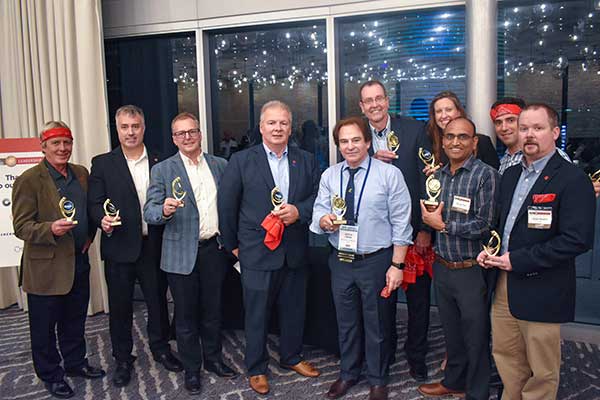
PNT CHAMPS: The L3Harris team earned the most total points in all six games, and took home a trophy each. (Photo: GPS World)
PNT Games
After dinner, guests broke into teams to test their personal positioning, navigation and timing skills, precisely determined by their ability to toss rings and throw horseshoes under time pressure. Each team rotated through yard games such as ladder toss, ring toss, corn hole and horseshoes to prove who was the most accurate and resilient. The L3Harris team took home the first-place prize.
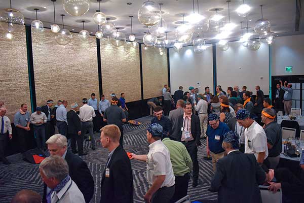
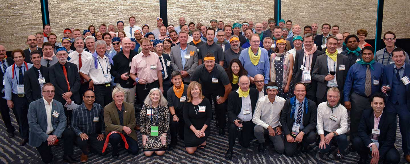
RAINBOW CONNECTION: Taking on giant pong are members of the rainbow bandana team, (from left) Sanjeev Gunawardena, Thomas Pany, Steffen Thoelert and André Hauschild. (Photo: GPS World)ORGANIZED CHAOS: Wearing different-colored bandanas, teams cheer on their team members and fight for every point. (Photo: GPS World)After all the awards were given, everyone got together for a memorable group photo. (Photo: GPS World)
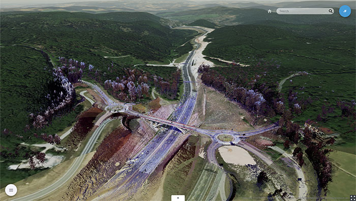
Trimble Clarity features cloud integration and support for 3D point cloud, imagery and mesh model formats. (Photo: Trimble)
Trimble’s browser-based viewer Trimble Clarity is now offered as a stand-alone web application, designed to simplify the visualization and navigation of 3D data.
According to the company, Trimble Clarity enables geospatial professionals to view, use and share 3D point cloud data, models and meshes with engineers, architects, city planners and other project stakeholders via a web browser, which can be viewed on desktop and mobile devices.
The Trimble Clarity web application allows users to generate private or public web links to share project information and 3D data. It also supports data from Trimble products, such as the Trimble SX10 scanning total station, Trimble TX Series 3D scanners and Trimble MX9 mobile mapping system, as well as data from non-Trimble sources.
In addition, with the upcoming version of Trimble Business Center office software 5.20, users can publish their 3D data directly into Trimble Clarity, creating a seamless integration and workflow between both platforms. Trimble Clarity provides a visual directory, which allows users to view 3D data as location-based projects.
Trimble Clarity also features cloud integration and support for 3D point cloud, imagery and mesh model formats.
“Trimble Clarity enables users to easily share and view rich 3D point clouds without having to transfer, copy or mail large data sets,” said Tim Lemmon, marketing director of Trimble Geospatial. “By leveraging an intuitive, browser-based experience, stakeholders can easily visualize and understand project data, enabling greater collaboration and informed decision making.”
Uber Elevate, Uber’s aviation division, unveiled a new food-delivery drone at Forbes’ Under 30 Summit in Detroit, according to various news reports.
The six-rotor UAV is vertical- and horizontal flight-capable, Uber Elevate head Eric Allison said at the conference. It has a range of 18 miles and an 18-minute flight time, and can carry enough food for two adults.
The drones will land in designated safe-landing zones, where human couriers will pick up the food and bring it to customers’ doors. The company might also land the drones on parked Uber cars (tagged with QR codes), which will carry the meals to their final destinations.
Uber’s Elevate Cloud Systems will track and guide the drone, as well as notify a delivery driver when and where to pick up the food.
The program is expected to roll out next summer in San Diego, where Uber Elevate has been testing urban aerial delivery via the UAS Integration Pilot Program (IPP).
Uber’s vision of a city sky filled with Eats delivery drones. (Image: Uber)
New solution integrates the real-time Kongsberg IRIS UAS airspace management picture into the AiRXOS’ Air Mobility Platform to provide integrated unmanned traffic management services around critical infrastructure
AiRXOS, part of GE Aviation, has fully integrated the real-time airspace picture from the Kongsberg Geospatial IRIS airspace management application into its own Air Mobility Platform for unmanned traffic management.
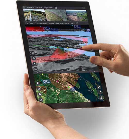
IRIS UAS is a spatial awareness system that allows UAS pilots to operate safely beyond visual line of sight (BVLOS). The system is shown here running on a Windows Surface Pro tablet. (Photo: Kongsberg Geospatial)
IRIS UAS fuses multiple disparate, real-time sensor feeds to create a highly accurate airspace picture around critical infrastructure locations such as airports.
This provides real-time calculation of aircraft separation, airspace monitoring alerts and communications line-of-sight prediction to enable detect and avoid for safe beyond visual line of sight (BVLOS) operations.
The real-time local airspace picture is then integrated into the cloud-based AiRXOS’ Air Mobility Platform, a dynamic, cloud-based foundation, purpose-built for advanced operations and the evolving future of transportation.
The Air Mobility Platform manages the volume, density, and variety of unmanned traffic management (UTM) data, and provides enterprises with a single platform to connect and manage operations, applications and devices.
Through this collaboration, the companies will provide UTM customers with a fully integrated view of airspace for real-time airspace insights, and greater scalability and repeatability of advanced operations.
“Situational awareness of the airspace across applications, unmanned aerial system (UAS) advanced operations, conformance monitoring, compliance, and pilots is critical to a UTM environment — allowing enterprises to be more responsive and efficient,” said Ken Stewart, CEO, AiRXOS. “Our partnership combines Kongsberg Geospatial’s expertise in airspace management with AiRXOS’ dynamic platform, applications, and services, providing customers with the opportunity to truly scale critical infrastructure advanced UAS operations like BVLOS and multi-vehicle, helping to lower risk and increase savings.”
“We’re very pleased to be working with an unmanned traffic management innovator like AiRXOS,” said Ranald McGillis, president of Kongsberg Geospatial. “Their ability to create a comprehensive surveillance view of operations and then to scale it for a nationwide use provides an excellent and very unique use case for our technology.”