Lidar USA has become the Titanium sponsor for the first UAS Rodeo, hosted by GEOHuntsville out of Hunstville, Alabama.
Operating since 1999, Lidar USA offers unmanned aerial vehicle (UAV) and mobile mapping systems for scanning, imaging and navigation.
Its products will be on display at the UAS Rodeo, which is designed to give Part 107 UAS pilots involved in public safety activities a full-scale training, skill-building and competitive environment to share knowledge in UAS operations.
The company said that integrating its mobile mapping solutions with the rapidly growing UAV industry has been pivotal to its success to adapt to a customer’s needs. UAS Rodeo will provide Lidar USA an avenue to show the UAS community its cutting-edge technology.
The UAS Rodeo takes place Oct. 9-10 in Huntsville at the Public Safety Training Academy, 6001 Cecil Fain Drive NW.
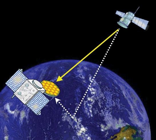
Your phone or satnav receiver routinely picks up signals from navigation satellites in order to tell you precisely where you are. But have you ever thought what happens to those satnav signals afterwards? A foresighted ESA inventor had the idea of using them as a tool for observing the Earth.
More than 120 satellite navigation satellites are in orbit, making up multiple constellations including Europe’s Galileo system, sending down a continuous rain of satnav signals for the benefit of users worldwide. Just like visible light, these microwave signals go on to reflect off Earth’s land and sea surfaces.
The traditional attitude to these reflected signals is to see them as something of a nuisance — known as multipath, they can confuse satnav receivers and reduce their overall accuracy.
ESA microwave engineer Manuel Martín-Neira, inventor of the PARIS reflectometry concept. (Photo: ESA)
But back in 1993 — at the same time as the US GPS satnav system reached its full constellation of 24 satellites — a young ESA microwave engineer called Manuel Martín-Neira came up with the idea of treating these satnav reflections as a scientific resource instead.
“My head of division asked me to come up with a budget-friendly way of increasing the overall sampling rate to build up a fuller picture of mesoscale phenomena, and that led me to start looking into making use of additional signals of opportunity, chiefly satnav signals.
“The initial reaction was mixed, because the forecast accuracy was not as precise as the ERS-1 altimeter could deliver — but on the plus side there would be a lot of these signals to make use of, and the performance has improved a lot since those early days.”
PARIS, detecting reflected satnav. (Photo: ESA)
Inspiration from reflection
The basic idea of what Manuel christened the Passive Reflectometry and Interferometry System, or PARIS, comes down to a two-sided antenna. As the topmost side picks up a satnav signal from the satellites in orbit, the other side picks up the version of the signal bounced back from Earth.
By comparing this initial, overhead signal with its reflected equivalent using a process called interferometry — measuring tiny differences in signal phases – the extra travel time of this reflected beam can be determined, down to an accuracy of less than five centimetres, determining sea height and sea ice thickness.
Additional amplitude waveform processing can deliver further data on wind and wave measurements over the ocean, and soil moisture and biomass over land.
Satellite reflectometry has since grown into a thriving field. This summer, Manuel attended the latest international workshop on the method he first devised 26 years ago.
Reflectometry reaches space
“It’s been fantastic to have experimental evidence, and that’s really been made possible by the growing availability of smaller satellites,” explains Manuel.
“Because satellite reflectometry is a passive form of remote sensing, it makes for an attractive potential payload because it doesn’t need a lot of power to operate. Then one of the results is meteorology data that private companies intend to make money with by delivering to public agencies.”
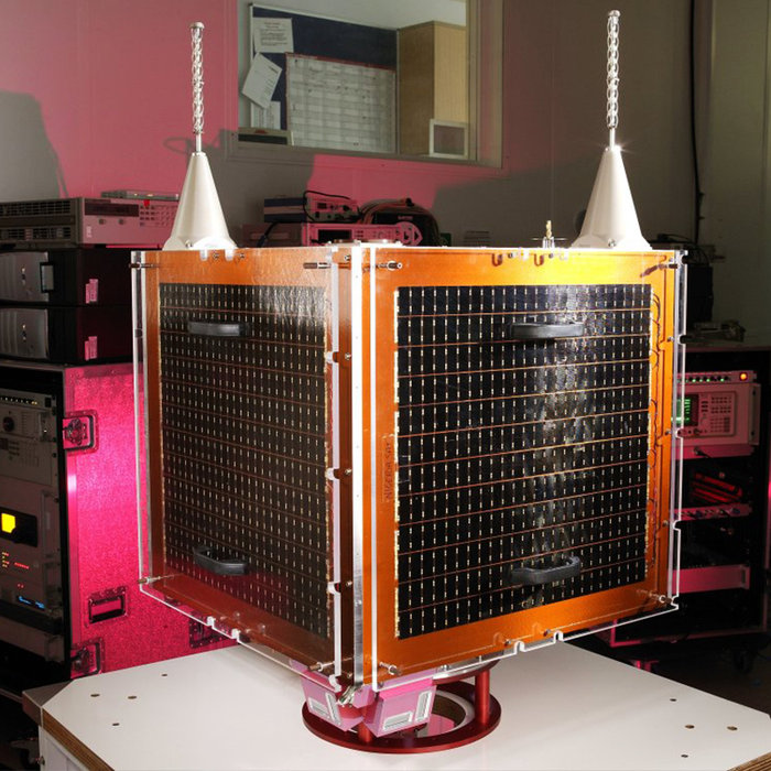
Surrey Satellite Technology Ltd.’s UK-DMC satellite was the first orbital mission with a reflectometry payload. (Photo: ESA)
In 2003, the UK-DMC satellite was the first mission to fly a reflectometry payload, followed in recent years by, for example, the UK’s TechDemoSat-1, NASA’s CyGNSS constellation to monitor hurricanes and the Spire global constellation of commercial nanosatellites.
“These satellites have really given the reflectometry community a wealth of signals, demonstrating what reflections look like over different surfaces including sea ice, forests, and even inland water bodies such as the Amazon River and its tributaries.
“In parts of the ocean near continental masses and within atolls we are seeing reflected signals from very calm waters which resembled a mirror, giving us very high precision down to 1 cm level. Such measurements could potentially complement current altimetry missions, by for instance measuring sea level rise.”
Example of a CYGNSS Microsatellite Observatory. (Image: Southwest Research Institute)
ESA activities taking flight
ESA meanwhile is active on reflectometry in various ways, having developed and tested a steerable airborne antenna called the Software PARIS Interferometric Receiver or SPIR, capable of steering separate antenna beams to build up a rapid surface picture, and differentiating between different signal sources, such as GPS from Galileo.
Manuel adds: “ESA’s GNSS Science Support Centre, based at the Agency’s European Space Astronomy Centre near Madrid, has been taking a keen interest in these activities.”
Missions are also in development, including a dedicated CubeSat with RUAG-Austria and the University of Graz called PRETTY (for Passive REflecTomeTry and dosimetry, which would also carry a radiation detector), and a small satellite pair called FSSCat from Spain’s Universitat Politècnica de Catalunya, backed through the Copernicus Masters competition, seen as a prototype for a future reflectometry constellation.
ESA’s Directorate of Telecommunications and Integrated Applications is also working with the Spire company to fly enhanced reflectometry instruments, starting at the end of this year.
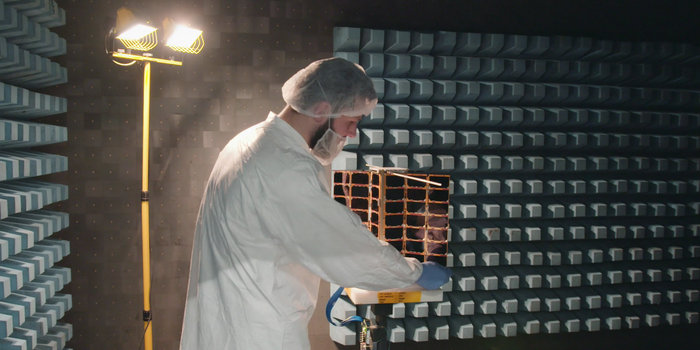
One of Spire’s Satellite Manufacturing Technicians (Tomasz Chanusiak) tests the Radio Frequency capabilities of a LEMUR2 nanosatellite in Spire’s cleanroom in Glasgow, Scotland. (Photo: ESA)
When it comes to the thriving state of today’s reflectometry community, Manuel recalls the patenting of his idea as a turning point: ‘Having had this idea, which was not particularly well received, the proposal by ESA’s Patents Group to patent it made all the difference. It gave me a feeling of confidence, that somebody else at least saw the potential of this idea — and the rest is history.”
Averna celebrated its 20th anniversary Sept. 20 as a test and quality solutions provider. Founded in 1999 by a team of three in Montreal, Quebec, Averna has grown to 400+ employees with 10 offices and more than 300 customers around the world.
“I am proud to see what Averna has become,” said Adil Lahlou, one of the co-founders of Averna. “We started Averna by understanding our clients’ manufacturing challenges and now reflecting on the continuing success we’ve had, it’s a reminder that we are still on the right path, particularly with the growth of Industry 4.0.”
Averna’s growth can also be attributed to business alliances. Company founders Kurt Hensen (T&M Solutions NV) and Darren Lingafeldt (Nexjen Systems) both believed that combining more than 100 years of test and quality experience would only benefit their customers and the industry.
“With each company bringing their own expertise to the forefront, different technologies are being exposed to a wider range of clients internationally,” the two said in a press release.
With proficiency in vision, RF signals, optics, precision assembly, robotics and automation, Averna has developed hundreds of unique solutions to service major industries such as medical technology, automotive and transport, and consumer goods and electronics.
Through standalone projects and complete program outsourcing, Averna’s global team has demonstrated its capability to support their customers at every step of the product life-cycle, the company said.
“What makes Averna outstanding is the willingness to consistently evolve and stay in front of our customers’ business needs,” said Francois Rainville, president and CEO of Averna. “It’s our employees’ enthusiasm to understand and tackle customers’ evolving requirements that has kept us ahead for the last 20 years and will continue to through the next 20.”
The new portfolio offers a comprehensive array of GNSS validation technology, as well as signal and PNT data protection through jamming/spoofing detection, suppression and countermeasure solutions.
The capabilities are built on Orolia’s legacy of resilient PNT solutions, together with two key acquisitions completed this year: Skydel Solutions and Talen-X. These companies were selected based on their demonstrated GNSS testing and simulation experience.
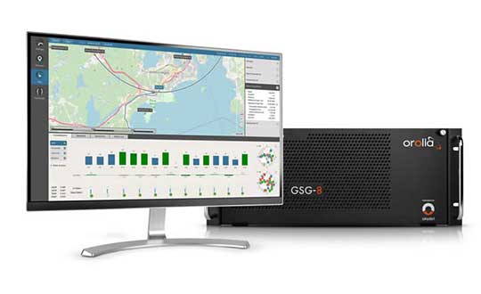
GSG-8, the latest advanced simulator from Orolia, was also introduced to the global GNSS community this week at ION GNSS+. This software-defined simulation solution offers ultra-high performance and unmatched flexibility in an easy-to-use format. GSG-8 was developed to deliver the highest standard of GNSS signal testing and sensor simulation performance, in an upgradable and scalable platform.
“With its scientific precision and advanced simulation capabilities, GSG-8 is revolutionizing the GNSS simulation industry with Orolia’s robust 1000Hz Skydel software engine and COTS software-defined radios,” said Stephane Hamel, director of testing and simulation at Orolia. “GSG-8 is designed for customers that require complex capabilities to validate product and program performance in harsh, high risk environments where failure is not an option- such as government agencies, space programs and specialized commercial programs.”
It can be programmed to simulate operations with multiple GNSS constellations and to incorporate the use of encrypted or proprietary signals. GSG-8 can also be configured for Wavefront and Anechoic chamber simulation protocols to test anti-jam antennas and complete systems, to serve the most challenging program requirements.
Hexagon showcased the Leica DSX utility detection solution at Intergeo 2019. (Photo: Allison Barwacz)
Hexagon AB presented its Smart Buildings & Infrastructure and Smart Cities & Nations portfolios at Intergeo 2019, which took place Sept. 17-19 in Stuttgart, Germany.
At the show, the company exhibited a number of its solutions designed to help manage the life of a building — from initial land surveying, through design, build, maintenance, renovation and demolition — and optimize the completion of infrastructure projects. These solutions include the Leica DSX utility detection solution, the BricsCAD building design software and HxGN SmartBuild.
Reality capture solutions showcased at Intergeo 2019 include Hexagon’s Leica BLK2GO mobile reality capture solution, the HxGN Content Program, and the Hexagon Smart M.Apps and Luciad portfolios.
“The ultimate form of data leverage is when tasks and processes become autonomous, which is the goal of our smart solutions portfolios,” said Ola Rollén, president and CEO at Hexagon. “We help customers leverage the data within their workflows to achieve the greatest efficiency, productivity and quality outcomes possible. When we collectively achieve these outcomes at scale, not only can we sustain growth for our businesses, but also this finite planet we all share…fewer resources, less waste, less pollution.”
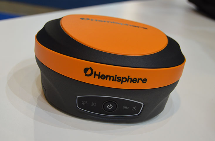
Hemisphere GNSS has introduced its multi-frequency, multi-GNSS S621 GNSS survey smart antenna and R620 GNSS receiver at Intergeo 2019 in Stuttgart, Germany, and ION GNSS+ 2019 in Miami.
S621 GNSS survey smart antenna
The S621 GNSS survey smart antenna is a complete redesign of Hemisphere’s previous generation version, the S321+. (Photo: Allison Barwacz)
The S621, powered by the company’s Phantom 40 GNSS OEM board, is a complete redesign of Hemisphere’s previous generation version, the S321+.
According to the company, the S621 processes and supports more than 800 channels with flexible and scalable simultaneous tracking of every modern and planned GNSS constellation and signal including GPS, GLONASS, BeiDou (including Phase 3), Galileo, QZSS, IRNSS, SBAS and Atlas L-band.
The S621 combines Hemisphere’s Athena GNSS engine and Atlas L-band correction technologies with a new WebUI. It meets IP67 requirements and is immune to magnetic interference. It is designed for use in land or marine survey, GIS, mapping, construction or other applications requiring high-performance precision and positioning, the company added.
“The S621 represents the advanced technology, durability, and ease-of-use that our customers have come to expect,” said Miles Ware, director of marketing at Hemisphere. “By redesigning this system from the ground up with increased functionality and management capabilities, we are offering unbeatable value.”
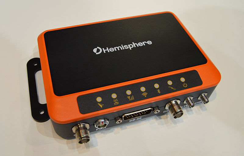
R620 GNSS receiver
The R620 GNSS receiver is a complete refresh of Hemisphere’s previous version, the R330. (Photo: Allison Barwacz)
The R620 GNSS receiver, powered by the Vega series, is a complete refresh of Hemisphere’s previous version, the R330, and includes an all-new low-profile ruggedized enclosure.
According to Hemisphere GNSS, the R620 GNSS receiver processes and supports more than 1,100 channels and offers flexible and scalable simultaneous tracking of every modern and planned GNSS constellation and signal including GPS, GLONASS, BeiDou (including Phase 3), Galileo, QZSS, IRNSS, SBAS and Atlas L-band.
The R620 combines Hemisphere’s Athena GNSS engine and Atlas L-band correction technologies with status LEDs and a WebUI. It also comes equipped with UHF (400 MHz and 900 MHz) radio, cellular modem, Bluetooth and Wi-Fi.
“With its all-new design and feature set, the R620 GNSS receiver is Hemisphere’s offering to what the market desires — smaller machine, lower cost and less power,” Ware said. “The receiver boasts a feature- and performance-packed combination of greater performance, improved robustness and excellent value.”
The VSP600L VeroStar supports the full GNSS spectrum, as well as L-band correction services. (Photo: Allison Barwacz)
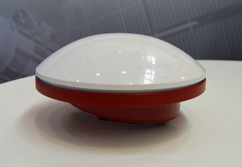
Tallysman has released its VSP600L VeroStar precision antenna at Intergeo 2019, which took place Sept. 17-19 in Stuttgart, Germany.
The VeroStar supports the full GNSS spectrum, as well as L-band correction services. The antenna provides low elevation satellite tracking with a high efficiency radiating element, the company said.
Its performance is suitable for real-time kinematic (RTK) and precise point positioning (PPP) applications. It features a light, compact and robust design. The antenna also has a low axial ratio through all elevation angles providing strong multipath rejection.
According to Tallysman, the VSP600L VeroStar also provides high receive gain over the full GNSS spectrum from low GNSS band (1164MHz to 1300MHz) L-band correction services (1539MHz to 1559MHz) to high GNSS band (1559MHz to 1610 MHz).
The antenna also has a low axial ratio through all elevation angles providing strong multipath rejection.
“The most unique feature of the VeroStar antenna is the high gain at low elevations,” Allen Crawford, director of key accounts at Tallysman, told GPS World at the show. “It can track low elevation satellites with a really high signal level, which is really important for those using correction services coming off of geostationary satellites. So as you go further away from the equator, you’re dealing with some very small link margins and you need those extra up to 4dB higher signal strength that this antenna provides.”
According to the company, it will soon be releasing embedded models of the VSP600L VeroStar.
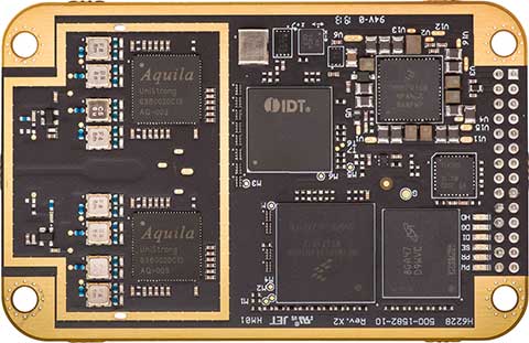
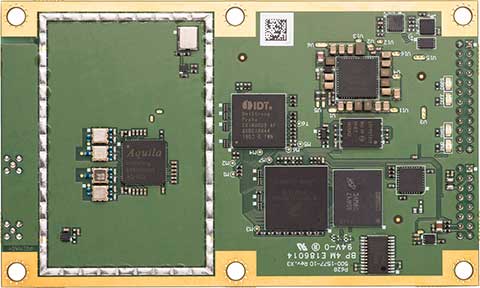
Hemisphere GNSS showcased its next-generation digital ASIC and RF ASIC interference mitigation platforms, and five positioning and heading OEM boards — the first products incorporating these powerful technological advancements.
Hemisphere is showcasing its new boards and technology at the Intergeo expo (hall 3, booth C3.030) and conference in Stuttgart, Germany, and the ION GNSS+ conference (booth 411) in Miami, Florida, both taking place this week.
Hemisphere’s Lyra II digital ASIC and Aquila wideband RF ASIC designs optimize performance and provide the ability to track and process more than 800 channels for position-only (the Phantom series boards) and more than 1,100 channels for position and heading (the Vega series boards), the company said.
Phantom 40. (Photo: Hemisphere GNSS)
This new ASIC technology offers flexible and scalable access to every modern and planned GNSS constellation and signal, including GPS, GLONASS, Galileo, BeiDou, QZSS, IRNSS, SBAS and Hemisphere’s Atlas L-band.
Signal support and tracking for AltBOC and BS-ACEBOC, BeiDou phase 2 and phase 3, L5 and QZSS/L6 (L6-D and L6-E) are also available.
The Lyra II and Aquila ASIC technology provides the foundation for a new GNSS receiver chipset architecture that significantly reduces the number of board components, thereby reducing complexity, improving reliability, and dramatically lowering power consumption.
Cygnus interference mitigation. The powerful technology platform also includes Hemisphere’s new Cygnus interference mitigation technology with built-in digital filtering capabilities and spectrum analysis. The new Cygnus technology provides enhanced anti-jamming, interference detection, and mitigation.
“This new technology platform and OEM boards represent significant improvements upon previous generation technology and hardware,” said Farlin Halsey, president and chief executive officer of Hemisphere. “With these outstanding advancements in our core technology and hardware, our customers and OEM partners are future-proofed and have flexibility and scalability with the highest-value access to all modern and planned signals.”
Vega 28. (Photo: Hemisphere GNSS)
The next-generation Lyra II, Aquila, and Cygnus technologies are available with the new Phantom 20, Phantom 34, Phantom 40, Vega 28, and Vega 40 OEM positioning and heading boards.
The Phantom 20, 34, and 40 positioning boards are the first Lyra II-based offerings in a line of all-new, low-power, high-precision OEM boards. They are multi-frequency, multi-GNSS receivers that boast more than 800 channels including access to Hemisphere’s Atlas GNSS global corrections network and offer serial, USB, Ethernet (Phantom 40-only), and CAN connectivity for ease of use and integration.
The Phantom 20 (41 x 72 mm module with 20-pin header), Phantom 34 (41 x 71 mm module with 34-pin header), and Phantom 40 (60 x 100 mm module with 24-pin and 16-pin headers) are significant upgrades for existing designs using these industry-standard form factors and offer power consumption of less than 1.8 W when tracking all signals, including L-band.
The Vega 40 and 28 are the first introductions in a line of all-new, low-power, high-precision, positioning and heading OEM boards. The multi-frequency, multi-GNSS Vega 40 and 28 GNSS receivers offer access to more than 1,100 channels including Hemisphere’s Atlas GNSS global corrections network.
The Vega 40 is a 60 x 100 mm module with 24-pin and 16-pin headers and is the ideal upgrade for existing designs using this industry-standard form factor. The Vega 28 is a 45 x 71 mm module with 28-pin header and is the smallest GNSS OEM heading module ever offered to the geospatial market by Hemisphere.
Combining data from GNSS and IMUs ensures accuracy during GNSS outages.
Leti, a research institute of France’s CEA Tech, and Orolia have announced a new sensor-data-fusion engine that ensures resilient positioning and navigation even in cases of GNSS jamming or spoofing.
Orolia is a leader in accuracy and performance for terrestrial, aeronautic and naval transportation positioning, navigation and timing applications.
Called FlexFusion, the algorithm technology processes data from GNSS, inertial management units (IMU) and odometers to provide precise positioning in all conditions.
Orolia will present its latest technological developments at ION GNSS+, booth 311, taking place in Miami, Florida, Sept. 17-19.
FlexFusion’s design relies on a modelization of GNSS and IMU (triple-axis accelerometer, triple-axis gyrometer and triple-axis magnetometer) output for synthetic trajectory generation.
The fusion approach exploits Bayesian estimators, such as Kalman filters. The first algorithm was setup on modeling signals, and its optimization relies on an extensive real-life sample database acquired through field test. This process used CEA-Leti’s HYLOC reference platform, which provides a reference positioning of a few centimeters.
More than 100 trajectory samples were collected in urban, suburban, forest and mountain environments with different GNSS outage conditions.
The new positioning technology supports edge artificial intelligence (AI) because the data-fusion algorithm is performed locally to ensure that positioning and navigation information is available locally and is failsafe even in case of jamming or spoofing of GNSS data.
“Recent events have demonstrated that it is possible to change the course of a ship or force a drone to land in a hostile area by simply spoofing GPS signals,” said CEA-Leti CEO Emmanuel Sabonnadière. “The increasing reliance on a GNSS for the execution of military operations and terrestrial, aeronautic and naval transportation requires using positioning and navigation systems that are able to detect GNSS outages and provide resilient position and navigation features.”
A version of FlexFusion that demands less of the CPU implements a loose coupling algorithm that uses GNSS receiver-output positions as entry of the algorithm. An advanced version implements a tight coupling fusion algorithm of GNSS and IMU data that significantly enhances the resilience of positioning and navigation under real-world conditions.
This novel approach enables total control of treatments and filtering applied to raw signals, which increases performance of the fusion. It also improves positioning performance in particular if there are fewer than four GNSS satellites available, or when there are recurrent multi-trajectories, which sometimes occur in urban canyons.
CEA-Leti has licensed the patented FlexFusion algorithm to Orolia.
“Orolia is integrating FlexFusion in a new version of its VersaPNT product, the first compact, all-in-one and resilient positioning, navigation and timing (PNT) system for vehicles and blue force tracking, tactical UAV navigation and marine applications,” said Thierry Delhomme, EMEA general manager, Orolia. “This powerful algorithm helps deliver on the promise of VersaPNT as an always-accurate PNT system that operates in any environment.”
FlexFusion development was supported and partially funded by the Easytech program of IRT Nanoelec, thanks to the French National Program “Programme d’Investissement d’Avenir” ANR-10-AIRT-05.
The u-blox ZED-F9P, a high-precision GNSS module that delivers centimeter-level accuracy within seconds, has been incorporated into the latest electric Tron F90+ fixed-wing unmanned aerial vehicles (UAVs).
Quantum-Systems, a German company that specializes in electric VTOL (vertical take-off and landing) aircraft for civilian use, manufactures the Tron F90+, which is employed in mission-critical logistical activities such transporting emergency blood reserves to remote locations. Other uses include mining and agriculture-related tasks.
Quantum-Systems and u-blox are both exhibiting at Intergeo in Stuttgart, Germany, Sept. 17-20. Quantum-Systems is at booth K1.074, and u-blox at booth L1.025.
The Tron F90+ has a 3.5-meter wingspan and can travel at speeds of up to 160 km/hour with a 100-km flight range. It is the latest addition to the Quantum-Systems eVTOL UAV platform designed for cargo, inspection, survey and mapping, and reconnaissance in adverse conditions. Other models include the Trinity F9, Scorpion and Vector UAVs, all of which feature u-blox F9 high-precision GNSS technology.
In developing the Tron F90+ UAV, the Quantum-Systems engineering team needed accurate enough position data to ensure that VTOL operations would always go smoothly, and the valuable payloads were protected from damage.
Through the multi-band real-time kinematic (RTK) and raw code and carrier-phase data available to the ZED-F9P, the necessary positioning correction is assured and the pilot can complete even difficult maneuvers. Absolute position accuracy can be brought down to 3-5 centimeters.
EOS has partnered with four high-resolution imagery providers — Airbus Defense and Space, SI Imaging Services, SpaceWill and 21AT — so users can purchase the latest images directly from LandViewer, the official high-resolution data reseller, or view the images of an area of interest in high resolution on the map.
LandViewer collects the latest up-to-date satellite imagery from commercial satellite providers and incorporates it into an easy-to-use platform. The collection is constantly being improved with new sensors.
LandViewer offers two data sources of commercial imagery:
High-resolution imagery (for analytics), to find and purchase high-resolution images for further in-depth analysis. In this case, the price is based on the size of the area of intersection between the selected image and your area of interest (AOI).
Image from Landviewer for analytics. (Image: EOS)
High-resolution imagery (view only) to view high-resolution images for your area of interest (AOI). In this case, the price is based on the number of tiles within your AOI. The view only option is designed as a stand-alone data source for the everyday business user.
Image from Landviewer (view only). (Image: EOS)
The EOS platform uses commercial imagery from LandViewer with a resolution between 0.3 meter and 1.5 meters, enabling a close look at assets of interest, anywhere in the world.
Pointfuse has released the latest version of its advanced point cloud processing software that converts the millions of individual measurements captured by laser scanning and photogrammetry.
Featuring new streamlined classification to ensure maximum efficiency and multicore processing for unlimited conversion power, the new version of Pointfuse is set to transform workflows within digital construction, facilities management and virtual design applications.
“Pointfuse is designed to make the use of point cloud data more accessible by removing many of the traditional barriers to use,” said Mark Senior, regional sales director at Pointfuse. “Obstacles such as processing time and computer power, incompatibility within existing workflows and outputs files that are large and complex; these have all been obliterated with the latest Pointfuse release.”
Pointfuse now includes a new streamlined workflow which makes object classification easy, using templates and shortcuts to ensure maximum efficiency. This ability to classify objects within Pointfuse has had a huge impact on how as-built data is utilized within digital design workflows; being able to quickly compare specific as-built objects with the design enables more accurate clash detection, reducing the number of false clashes being flagged.
IFC (Industry Foundation Classes — an open format data model that is intended to describe architectural, building and construction industry data) templates can also be created and edited for specific applications. With applications including architectural, MEP and HVAC, selected objects can be classified and mapped to ensure compatibility with onward workflows.
Pointfuse also includes a new conversion engine which uses multicore processing to manage and enable unlimited point cloud conversion to provide real scalability. In addition, Pointfuse’s mesh models are intelligently optimized, reducing the working data size by a factor of up to 100, making them easy to share with online 3D collaboration platforms, such as BIM 360, 3D Repo, Revitzo and Trimble Connect.
“Using Pointfuse we can create intelligent 3D mesh models in a fraction of the time,” commented Ben Callan, BIM coordinator in global construction services company ISG’s UK Fit Out business. “This accelerated modelling and reduced risk of error contributes to a direct reduction in costs when compared against traditional methods of modelling and point cloud data analysis. The easy to use, easy to consume outputs are also paving the way for new applications of the data including existing versus design clash avoidance and checks of temporary works against required construction activities.”