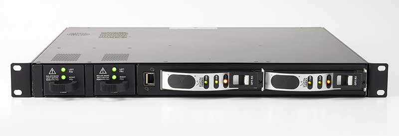
ViaLite’s new Local Integrated GPS Splitter was designed to minimize rack space. Suitable to applications requiring a fan-out of GPS/GNSS signals within a single local area, the unit can accept optical inputs from up to four antennas.
Though it has a height of only one rack unit, the system is suitable for feeding timing and synchronization signals to single or multiple floors or rooms through 8 to 32 optical fiber links with no system loss.
Available with 1×8, 2×8, 4×8, 1×16 and 2×16 options, the easy-to-install GPS Splitter has a 1000-1800-MHz frequency range. Built-in simple network management protocol (SNMP) control is included as well as dual-redundant power supply units.
Typical application areas include data centers, banking institutions, scientific research establishments, cellular test environments, fixed satcom Earth stations and teleports, oil and gas platforms, and big data.
“Our new GPS Splitter was developed in response to customer demand across a wide range of sectors,” said ViaLite Product Manager John Golding. “We are pleased to have been able to meet their needs by providing a very high-quality product at a reasonable cost.”
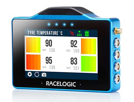
The VBOX Touch from Racelogic is the first in a new generation of highly flexible, enhanced accuracy GNSS dataloggers. The powerful hardware can be used in many types of diverse automotive tests such as acceleration, braking, speed verification, tyre temperature monitoring, lap-timing and durability, according to the company.
The VBOX Touch comes preloaded with a sophisticated performance application that covers many common use cases. Other applications can be downloaded free of charge from the Racelogic online library. Racelogic can also write custom scripts based on customer requirements.
The VBOX Touch has a daylight readable colour touchscreen, 10-Hz GNSS engine, Wi-Fi, Bluetooth, twin CAN ports, serial port, digital input and four multi-color LEDs.
Applications are written in Python script, offering greater flexibility as well as the potential for users to write code to solve their specific testing requirements. If you need a configurable, touchscreen display which can interact with two different CAN buses, log data, know the precise position and speed whilst giving clear feedback to drivers, then the VBOX Touch is for you.
A high-accuracy 2-cm RTK GPS version is available, which uses the latest dual-frequency GPS, GLONASS and Galileo signals to deliver accuracy even under difficult conditions. These new signals significantly increase the RTK resilience near trees and tall buildings, providing precise lap-timing, position triggers and trajectory maps in places where 2-cm GPS has typically not been available.
Founded in 1992, RACELOGIC are based in Buckingham, UK, and have supplied the Automotive industry with reliable and accurate GPS dataloggers for the last 18 years. In the development of the VBOX Touch we have worked closely with our end users to create a powerful tool to help them deliver results faster and more accurately on the test track or open road.
Flirtey, a pioneer of the commercial drone delivery, has unveiled the Flirtey Eagle, along with a video of the next-generation delivery drone performing consumer and automated external defibrillator (AED) deliveries to homes.
Flirtey’s system is designed to safely get packages to customers with the delivery goal of less than 10 minutes using drones.
Along with the Flirtey Eagle, the aircraft designer and manufacturer unveiled the Flirtey Portal, a sophisticated takeoff and landing platform that enables scalable store-to-door operations. Also part of the system is an autonomous software platform that enables drones to deliver safely to American homes.
Flirtey said it is on course to conduct drone deliveries to U.S. homes as early as 2019.
Here are highlights of the UAV’s technology.
Flirtey’s aircraft is designed to operate in 95% of wind and weather conditions, making it highly reliable for flight.
The Flirtey Eagle is designed to fit 75% of packages that get delivered to its customers’ homes during last-mile deliveries.
The Flirtey Eagle safely and precisely delivers its contents by lowering a tether, while the drone is suspended in air, and once the package is delivered, it then retracts the tether.
Flirtey’s aircraft is controlled by its autonomous software platform, which has received Federal Aviation Administration (FAA) approval for the first multi-drone delivery operation in the United States, enabling a single remote pilot to simultaneously oversee ten Flirtey drones.
Flirtey’s Portal is a sophisticated takeoff and landing platform that fits into one parking space, making its infrastructure easily scalable to the company’s partners for store-to-door delivery.
Flirtey’s drone delivery technology has been developed from the ground up, originating from NASA’s drone program. Flirtey Founder and CEO Matthew Sweeny has brought together a team of aviation industry veterans from NASA, Raytheon, Lockheed Martin, and SpaceX, as well as military veterans from the army, navy, and air force.
“We expect Flirtey’s advanced drone delivery system will become the industry standard in America,” said Matthew Sweeny, Flirtey founder and CEO. “Flirtey’s latest technology makes life-saving and commercial drone delivery to homes in the United States an imminent reality.”
The Flirtey Eagle builds upon the advanced technologies developed for Flirtey’s previous generation aircraft that conducted the first Federal Aviation Administration (FAA)-approved drone delivery in the United States, which is going on display alongside the Wright Flyer in the Smithsonian National Air and Space Museum in Washington, D.C. Flirtey’s goal is to not only meet, but to surpass the rigorous safety standards of the FAA. Flirtey’s regulatory approvals include:
Approval to conduct multi-drone delivery operations, enabling a single remote pilot to simultaneously oversee 10 Flirtey drones
Approval to conduct drone delivery flights beyond visual line of sight (BVLOS), enabling Flirtey to conduct drone delivery operations with a pilot controlling the flights from a remote location
Approval to conduct drone delivery flights at night, making drone delivery accessible at any time
Flirtey and the City of Reno were chosen for the FAA and Department of Transportation’s Unmanned Aircraft System (UAS) Integration Pilot Program (IPP). Within the IPP, Flirtey and the City of Reno have partnered with REMSA, local emergency medical services provider, to deliver AEDs to those in need. Flirtey’s AED delivery technology has the potential to save 150,000 lives per year, the company said.
Based on demand from customers, Flirtey expects demand initially to outstrip supply. Flirtey’s drone delivery system was designed from the outset to meet the anticipated high demand.
Updated GSS9000 Series takes a bow, joining range of test solutions on show
The Enhanced GSS9000 Series GNSS constellation simulator. (Photo: Tyler Gunter)
Spirent Communications will unveil its enhanced GSS9000 Series GNSS constellation simulator at ION GNSS+ 2019 in Miami, which will take place Sept. 16–20. It joins Spirent’s already impressive range of test solutions on display at the world’s largest showcase of GNSS technology, products and services.
“The industry is at a very important point,” said Spirent Marketing Director Steve Hickling. “With the volume of GNSS signals growing, more multi-constellation receivers being developed every day, and the need for greater precision increasing all the time, it’s vital that testing solutions are able to stay ahead of this reality. This is why we’re excited to demonstrate the enhanced GSS9000 Series at ION.”
The GSS9000 Series constellation simulator has been improved with enriched features and enhanced capabilities combined with an increased channel capacity. Most importantly, this greater flexibility, coherence, fidelity, performance, accuracy and reliability is maintained under all test conditions.
At ION, Spirent (booth E) will also be showing its GSS6450 — the highly portable 16-bit RF record and playback system — and the GSS7000 series multi-frequency, multi-GNSS RF simulation solution. Visitors can also learn more about Spirent’s realistic multipath and obscuration simulation tool, the new Sim3D.
Spirent’s expertise will also be demonstrated during three ION GNSS+ speaking panels:
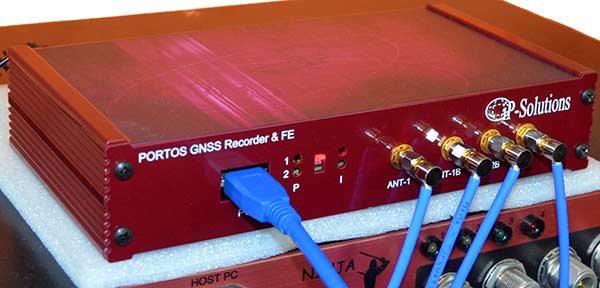
Portos Team paired with the Ninja. (Photo: iP-Solutions)
Japan-based iP-Solutions has introduced Portos Team, a new GNSS RF signal record-and-playback system.
The Portos Team can record and play back — or simulate —multi-frequency, multi-system GNSS signals when paired with the company’s Replicator. It can do the same for CRPA signals when paired with the Ninja (see photo).
The Portos itself can also operate as multi-frequency or CRPA front-end for a GNSS software receiver.
The high-end Ninja simulator allows for multi-antenna controlled radiation pattern antenna (CRPA) and local-area augmentation system (LAAS) simulation, the company said.
The 24-channel Replicator — developed in collaboration with the Japan Aerospace Exploration Agency (JAXA) — provides real-time generation of GNSS signals, recording and playback of dual-frequency GNSS RF signals, and GNSS RF signal analysis with JAXA COSMODE ionospheric scintillation monitor.
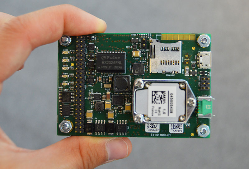
Septentrio has introduced a GNSS/INS receiver designed specifically for unmanned aerial vehicles (UAVs). The AsteRx-i S UAS combines GNSS technology with industrial-grade inertial sensor to provide high-accuracy, reliable positioning and 3D orientation (heading, roll, pitch) to aerial drones and other compact robotic systems.
Septentrio’s introduction of AsteRx-i S UAS builds on top of the success of the company’s existing UAV products, AsteRx m2 and m2a UAS. Its optimized SWaP (size, weight and power) increases UAV battery life resulting in longer flight times and improved productivity.
Intergeo, Hall 1, Booth D1.040, Sept. 17-19, Stuttgart, Germany
Photo: Allison Barwacz
This credit-card-sized receiver is designed for easy integration into any UAS (unmanned aerial system) and is compatible with popular autopilots such as Pixhawk and ArduPilot. It is a single-package GNSS/INS product, with an on-board IMU (inertial measurement unit) and standard connectors, allowing flexibility of sensor choice.
“Quick receiver integration makes the lives of our customers easier. It also speeds up their system’s time-to-market,” said Danilo Sabbatini, Product Manager at Septentrio. “Our goal was to combine a high-performance product with a simple and flexible plug-and-play integration design, suitable for any aerial system.”
Septentrio reliable centimeter-level positioning is based on multi-frequency, multi-constellation GNSS technology (GPS, GLONASS, Galileo, BeiDou, QZSS). AsteRx-i S UAS combines a GNSS receiver with a high-quality IMU to deliver reliable positioning together with 3D orientation.
Septentrio’s unique GNSS — IMU integration algorithm provides continuous positioning during short GNSS outages (coasting) which can happen in flight near high structures, under bridges or during banking turns.
AsteRx-i S UAS comes with built-in industry leading Advanced Interference Mitigation (AIM+) technology. In aerial drones, where lots of electronics are crammed into a small space, neighboring devices can emit electromagnetic radiation which interferes with GPS and GNSS signals.
AIM+ offers protection against such interference resulting in faster set-up times and robust continuous operation. A built-in power spectrum plot allows users to analyze interference, helping locate its source and mitigating it.
Skyfront’s Perimeter 4 long-range hybrid gas-electric drone this summer successfully performed the first civilian beyond-visual-line-of-sight (BVLOS) flight without visual observers under the FAA’s Part 107 rules.
The flight serves as a significant step toward the safe integration of unmanned aerial vehicles into the national airspace, according to the company.
During the round-trip flight, the Perimeter UAV flew over mountainous, rugged terrain along a four-mile stretch of the Trans-Alaska pipeline. The UAV maintained a constant above-ground altitude of 400 feet with multiple ascents and descents of 1,000 feet on 45-degree slopes. Radio-based telemetry, command and control of the vehicle was uninterrupted during the flight.
FAA representatives observed all aspects of the mission, including planning, system setup and ground-station operation. The Perimeter “did [the flight] safely, effectively and efficiently. It accomplished a beyond-visual-line-of-sight mission, and it was approved by the FAA,” said Robert Huber, program manager for the Integration Pilot Program (IPP) of the FAA.
“Today’s flight was a milestone in the unmanned community,” said Troy Mestler, CEO of Skyfront. “We at Skyfront are excited to be pushing the limits of unmanned aerial vehicles here in the United States.”
The Perimeter UAV was integrated with Iris Automation’s Casia collision avoidance system and was observed by Echodyne’s ground-based detect and avoid systems.
The University of Alaska Fairbanks and the Alaska Center for Unmanned Aircraft Systems Integration purchased the UAV and organized the flight over the pipeline, with the approval of the Alyeska Pipeline Service Company.
Japan-based Terra Drone’s newest branch, Terra Drone Australia, will focus on the mining, oil and gas, power and forestry sectors.
Terra Drone Corporation, an industrial drone services provider headquartered in Tokyo, has finalized its expansion into the Australian market after completing an equity investment in Australian firm C4D Intel Pty Ltd. As part of the deal, C4D Intel will immediately rebrand to Terra Drone Australia.
The move by Terra Drone is the latest of the company’s investments into drone technology businesses across the globe and demonstrates the Japanese company’s commitment to the Australian market. The terms of the transaction were not disclosed.
Founded in 2016, C4D Intel provides surveying, inspection and 3D modeling services to a diverse client base across mining, oil and gas, power and forestry industries in Western Australia.
The company specializes in large-scale unmanned aerial surveys, confined space infrastructure inspections, high-altitude inspections, bridge and pipeline inspections, and asset 3D modeling.
As Terra Drone Australia, the company will be able to leverage the additional growth capital to expand its service offering to include unmanned airborne lidar, bring innovative Terra Group technologies to Australia, and expand its operations to the East coast of Australia, Terra Drone stated in a press release.
The Australian drone service provider’s existing clients include mining companies Rio Tinto and Fortescue Metals Group, and large utilities such as ATCO Gas Australia and Synergy.
“We are delighted to join the No.1 industrial drone services company in the world, Terra Drone. When the world’s fastest-growing drone business chooses to expand to Australia, and selects our business to invest in, it speaks volumes about the opportunities available here and the vision we have for the company,” C4D Intel Operations Manager Will Wishart said.
“There are many advantages of being a part of a global organization and this next phase of growth makes for very exciting times. We have already leveraged Terra Drone’s international network to bring new technology to Australia and look forward to accelerating this as we expand our operations across the Australian continent.”
Terra Drone Corporation CEO Toru Tokushige added, “The establishment of Terra Drone Australia is another milestone for our international expansion strategy. Australia bears a strategic significance in our growth plans. Having a local presence in the region allows us to be close to our customers and strengthen our support to them.”
Later this month, Terra Drone Australia will bring innovative drone technology from The Netherlands to Australia for proof-of-concept trials for global mining company Rio Tinto. The Terra UT Drone from Terra Inspectioneering will allow Terra Drone Australia to offer ultrasonic thickness testing of steel in hard to reach places, such as bin walls which are subject to wear.
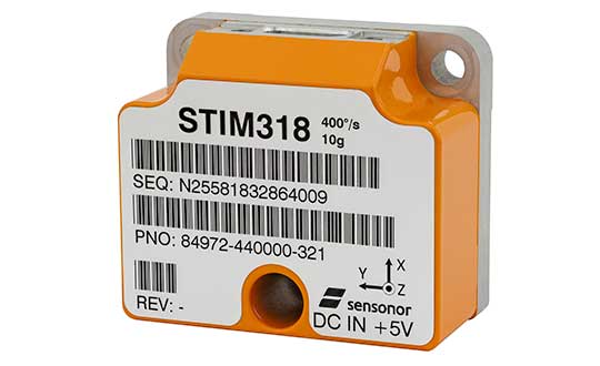
The new high-accuracy tactical-grade STIM318 inertial measurement unit (IMU) from Sensonor provides greatly increased accelerometer performance to support demanding guidance and navigation applications, the company said. Its performance can in many applications competitively replace fiber-optic gyros (FOGs).
Offering improved system performance with respect to robustness, reliability, size, weight, power and cost, it is designed for use in autonomous machine control, UAV payloads, satellites, portable target acquisition systems, land navigations systems, turret stabilization, missile stability and navigation, and mortar aiming systems.
STIM318 is comprised of three highly accurate MEMS gyros, three high-stability accelerometers and three inclinometers. Its development took place in close cooperation with a global customer developing autonomous machine control for accurate contour guidance. The IMU is built on the established STIM design that is field proven in commercial and military applications.
An ITAR-free product, STIM318 is available in export controlled and non-export controlled versions. It is compatible with Sensonor’s STIM300 IMU, and can bring additional capability to applications already using STIM300. STIM318 is available from stock.
In addition to the performance increase, STIM318 comes with a new Bias Trim Offset (BTO) function. This allows the user to individually zero out any bias of all 9 axes. The bias offset can be stored in flash, and then recalled at next system startup.
Providing significantly improved capability, flexibility and performance, the GSS9000 Series has been updated to meet the ever more demanding test needs of high-performance satellite navigation systems.
Spirent already leads the market in multi-frequency, multi-GNSS RF constellation simulators, and the enhanced GSS9000 Series’ enriched features and capabilities raise the bar for GNSS development and test still further.
Photo: Spirent
“We’re seeing the number of GNSS signals growing all the time, and an ever-increasing number of the receivers and systems we rely on every day are making use of these signals to improve accuracy, availability and continuity,” said Spirent Managing Director of Positioning, Martin Foulger. “That’s why it’s important that GNSS testing today and going forward reflects the reality of real-world situations, where simultaneous generation and testing of all signals is vital.”
The enhanced GSS9000 Series addresses this need by doubling the number of supported channels (320 in a single chassis) while maintaining its full performance specification, including in key areas such as signal iteration rate and low latency, under maximum signal dynamics.
These attributes, together with the ability to produce a comprehensive range of emulated multi-GNSS, multi-frequency RF signals, enables full and future-proofed testing of advanced applications.
“Because the GSS9000’s dedicated platform and software are designed from the ground up to work together, there is no need for a trade-off between capacity and performance,” says Foulger. “The newly-enhanced platform provides full control and verification at maximum performance across all channels at all times, removing any need for our customers to compromise their testing regimes.”
Greater signal flexibility is also built into the enhanced GSS9000 Series, through its open API and flexible system architecture. This delivers a highly-sophisticated arbitrary waveform generator (AWG) capability.
It also provides unrivalled coverage and support for all current Signal-in-Space Interface Control Documents (SIS ICDs), with even greater flexibility for both system and signal evolutions.
This includes built-in and user-defined parameter controls for generation of non-current SIS ICD PRN codes, navigation data content, navigation data rate, chipping rate, edge shaping and modulation types.
The enhanced GSS9000 Series also features sophisticated spoofing test capabilities, with full parametric control of multi-copy constellations, and trajectory spoofing/meaconing. Precise phase-aligned signal wavefront generation and multi-antenna/output capability is supported, creating the most capable anti-jam and anti-spoof test system available anywhere.
“Spirent has an unmatched pedigree in GNSS test, stretching back more than 30 years. The enhanced GSS9000 Series is the next step in the continuous advances we’ve been making over that period,” Foulger said. “Once again, we have applied our unique expertise and experience to provide those working in high-end GNSS technology and application development with an advanced test solution that meets their current and future needs.”
The enhanced GSS9000 Series will be officially unveiled at ION GNSS+ 2019 in Miami, Florida (Sept. 16 – 20).
UAvionix is offering free pingRX unmanned aircraft system (UAS) ADS-B receivers to first responders and UAS service organizations participating in rescue and recovery efforts associated with Hurricane Dorian.
Hurricane Dorian is expected to travel along the Eastern coast of the U.S. northward at a slow pace, creating extensive damage from winds and flooding.
UAvionix is a designer and manufacturer of communications, navigation and surveillance (CNS) equipment for unmanned and manned aircraft.
The pingRX. (Photo: uAvionix)
PingRX is a dual-frequency ADS-B receiver designed for use onboard a UAS. Retailing for $249 and weighing 5 grams, pingRX can provide the operator with a digital view of ADS-B-equipped aircraft in the airspace up to hundreds of miles away.
When integrated with a compatible autopilot — such as ARDUPILOT, Pixhawk, PX4 or the Cube — local ADS-B traffic is displayed on the ground control station (GCS) display.
Image: National Weather Service
The FAA’s mandate for ADS-B OUT equipage on manned aircraft has a deadline of Jan. 1, 2020, so equipage levels are currently high. Users are cautioned, however, that equipage is not at 100%, so reliance on ADS-B as a sole means of detect and avoid (DAA) is not advised.
In 2017, in response to Hurricane Harvey’s landfall in Houston, Texas, UAS were used extensively for the first time in recovery and rescue efforts. The use of UAS has continued to grow in response to hurricane efforts ever since.
Photos: NOAA
“Over the past few years, the use of drones in hurricane and natural disaster recovery efforts has increased significantly due to the value of the real-time data collected in combination with ease of deployment,” said Christian Ramsey, uAvionix president. “First responders and recovery crews will undoubtedly work tirelessly for weeks in response to Dorian. We hope to make these efforts just a bit safer and encourage good airspace safety practices with the use of the pingRX systems.”
The FAA has published guidance for UAS operators, urging strict adherence to Notices to Airmen (NOTAMS) and Temporary Flight Restrictions (TFR). The airspace in these areas can be crowded and unpredictable.
First responders and UAS service organizations are encouraged to contact uAvionix at [email protected] for details on the offer.
Grand Bahama Island before Hurricane Dorian. (Photo: Google)
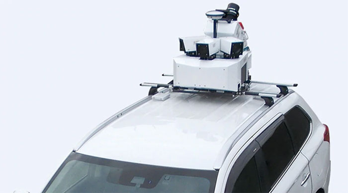
According to Mitsubishi Electric, its Mobile Mapping System uses car-mounted GNSS antennas, laser scanners and cameras to gather 3D positioning data for road assets with high-level accuracy. (Photo: Mitsubishi Electric)
Mitsubishi Electric Europe B.V. has established a High Precision Positioning Systems Division at its German branch headquarters in Ratingen, Germany.
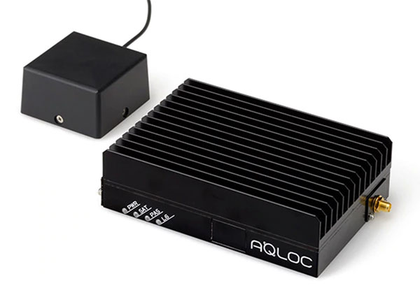
According to the company, the new division offers key technologies to German and European customers to accelerate the introduction of centimeter-level autonomous driving and safe driving assistance. These solutions include the Mobile Mapping System (MMS) and the high-precision AQLOC positioning receiver with centimeter-level accuracy for applications in road and utility vehicles, harbors and drones, as well as the agricultural sector.
AQLOC will be compatible with GNSS services and positioning data augmentation services by Sapcorda, a joint-venture by Mitsubishi Electric, Bosch, Geo++ and u-blox. MMS uses car-mounted GNSS antennas, laser scanners and cameras to gather 3D positioning data for road assets with high-level accuracy, creating the comprehensive, high-definition 3D maps needed to support autonomous driving, the company said.
The high-accuracy positioning receiver AQLOC will be compatible with GNSS services and positioning data augmentation services provided by joint venture Sapcorda. (Photo: Mitsubishi Electric)
“We are happy to add this new business area to our wide-ranging mobility solution portfolio, which already includes automotive equipment, power devices and railway systems,” said Andreas Wagner, president of the German Branch of Mitsubishi Electric Europe B.V. “The High Precision Positioning Systems Division rounds out our mobility sector and will offer German and European customers essential technologies for highly precise autonomous driving systems in a variety of scenarios.”
Mitsubishi Electric Corporation is making mobile mapping and high-precision positioning systems available in Europe, North America, Asia and Oceania. The company also will showcase the new business unit’s portfolio at Intergeo 2019, which will take place Sept. 17-19 in Stuttgart, Germany.