NovAtel, part of Hexagon’s Positioning Intelligence division, now brings users greatly improved processing speed and accuracy as well as significantly reduced signal acquisition time through the latest 7.07.03 firmware release.
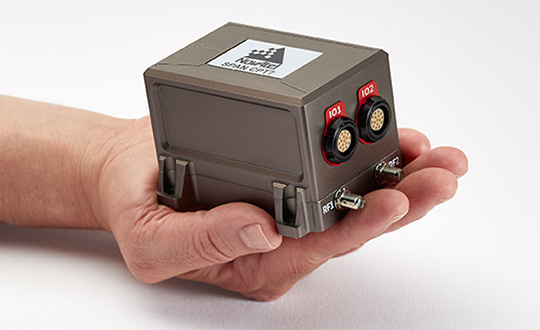
The SPAN CPT7. (Photo: NovAtel)
The firmware works best with the recently launched TerraStar-X correction service, which delivers accuracy and reliability, as well as the OEM7, SPAN CPT7 and PwrPak7 products, which use signals from all GNSS constellations and frequencies to provide users with reliable autonomy and exceptional positioning availability.
The 7.07.03 firmware offers a significant improvement to the SPAN GNSS + INS (inertial navigation system) technology. SPAN with 7.07.03 shows improvements of up to 20% in the horizontal position over the entire SPAN IMU catalog and across various industry use cases including agriculture and marine. SPAN with 7.07.03 also provides improved motion detection, resulting in more robust time to convergence.
“The 7.07.03 firmware features improvements to both our SPAN Marine and SPAN Rail profiles that will greatly impact application performance and consistency,” noted NovAtel Director of Product Management, Neil Gerein, “The SPAN Marine Profile sees improvements to the heave performance and will allow users to start their work significantly faster thanks to a simplified setup for applications in marine dynamics. The SPAN Rail Profile improves position accuracy over long GNSS outages, which is crucial for applications in rail environments that often deal with potential signal obstructions such as trees, tunnels and dense urban areas.”
To download the 7.07.03 firmware update for your platform, click here.
3D modeling solution creates true-to-life synthetic environments for more accurate testing.
Spirent Communications plc has launched an innovative multipath simulation solution, Spirent Sim3D. The 3D modeling solution enables the testing of realistic multipath and obscuration effects on GNSS signals in a true-to-life synthetic environment.
Sim3D is suitable for use by automotive, chipset, handset and receiver manufacturers, as well as in aerospace, military, mining and precision agricultural applications.
Spirent will demonstrate Sim3D at ION GNSS+ 2019 in Miami, Florida, Sept. 16-20.
Studying multipath. Historically, researchers and developers of GNSS receivers have had to rely on statistical models and time-consuming field testing to study the effects of multipath on GNSS signals.
With Sim3D, the industry can now gain a greater understanding of the impact of multipath and obscuration in a broad range of real-life situations. It offers the level of control and traceability needed for developers to improve their customers’ experience in the most challenging environments.
A satellite signal reflecting off surfaces, such as a building, a high-sided vehicle, a tree, or even the ground, alters the pseudorange, causing the signal to arrive at the receiver slightly later than line-of-sight signals.
Without proper mitigation, this can cause a receiver to output an inaccurate position.
“Obscuration and multipath effects are one of the major obstacles faced by engineers trying to achieve accurate GNSS positioning solutions,” said Spirent Managing Director of Positioning Martin Foulger. “The accelerating development of connected autonomous vehicles and other precision applications means the need to test for higher precision positioning, navigation and timing in a variety of environments is growing rapidly. Sim3D is an important and timely development.”
Image: Spirent
Simulation of 3D environments. The unique system has been developed in partnership with OKTAL Synthetic Environment. It offers the ability to simulate multipath effects in a range of lifelike geo-typical environments, using different models to recreate locations such as urban highway, an inner city or a forest. Geo-specific models of real locations can also be commissioned.
During simulation with Sim3D, the GNSS signals interact with fully customizable 3D environments to simulate real-life applications in operation, like a vehicle on a highway, or a wearable device on a pedestrian.
This gives a level of detail, control and realism in testing not previously available. Such realistic multipath and obscuration simulation will add greater credibility to GNSS testing and assure that developed solutions are optimized and tested for their intended environments.
“As vehicles become increasingly autonomous, it’s vital to get a more detailed understanding of the effects of obscuration and multipath on a vehicle’s ability to generate an accurate GNSS-based position” explained Foulger. “Statistical models cannot sufficiently achieve this.
“Sim3D’s ability to realistically simulate different environments provides this greater accuracy and brings a host of benefits to researchers and developers of autonomous vehicle systems,” Foulger said. “It will help to guide critical design decisions like where to place the GNSS antenna on the vehicle, what GNSS receiver to use and when to hand over to other position sensors as GNSS signals degrade.”
Safely integrating autonomous drones into global airspace is the goal of Altitude Angel.
The company has completed its involvement in the Gulf of Finland (GOF) U-Space project, declaring the trials to have been a “huge success” and an “amazing showcase” of its unmanned traffic management (UTM) technologies.
The GOF U-space demonstrations are funded by the SESAR Joint Undertaking for European sky air traffic management research.
In July and August, advanced drone operational demonstrations took place across Estonia and Finland, showcasing use cases that involved both manned and unmanned aircraft in shared airspace. The demonstrations relied on systems such as Altitude Angel’s GuardianUTM O/S to remain safe.
GuardianUTM, the company’s core system, is already helping drones operate in controlled airspace. It powers the UK’s national UTM system, operated by NATS, the UK’s main air navigation service provider.
Altitude Angel was a key UTM partner for the trials, providing services that included integration to the FIMS (flight information management system) for the transport of flight plans, telemetry/position reports, AIM (geofencing/volume reservations), as well as alerts and registration data to-and-from the drone operators and manned aviation which were involved in the trials.
Altitude Angel was able to demonstrate its UTM platform across a number of scenarios that varied in scope and range, and included:
urban drone fleet operations with police intervention,
long-distance multisensory inspection flights over forests,
urban drone operations in controlled airspace,
powerline inspection in rural areas, maritime search and rescue, and
international parcel delivery.
The demonstration series concluded with an urban Volocopter air taxi flight around Vantaa International Airport, Helsinki.
“We’ve been working with the SESAR team for over a year on this project. It’s been a great few months in Finland and Estonia supporting the live demonstrations which have been huge success and an amazing showcase of our world-leading UTM technologies,” said Simon Wynn-Mackenzie, Altitude Angel’s head of products.
“Not only did the scenarios give us another opportunity to demonstrate our production UTM platform in another real-life environment, they went a long way to showing the public how drones can be used in a positive and socially beneficial way on a daily basis,” Wynn-Mackenzie said.
“Our only disappointment was that we were not able to demonstrate our world-first Conflict Resolution Service which we unveiled in July, as the trial scenarios had already been agreed. However, we’ll be looking to showcase our constantly evolving platform and several new services very soon,” he said.
Other UTM demonstrations. In November 2018, Altitude Angel led the team behind Operation Zenith, which gave a view of the future of air traffic management and drone integration into busy, complex airspace, demonstrating how by using the right technology, it’s possible to safely integrate unmanned traffic into controlled airspace and open the skies to commercial airspace worldwide.
The U-space initiative. The GOF U-space project, with a broad consortium of 19 members, demonstrates Europe is on course with its implementation of U-space, an initiative that aims to ensure safe and secure drone traffic management, taking into account the rapid growth in the use of drones.
The GOF concept enables shared situational awareness for all aviation stakeholders. The success of the project is based on deep air traffic management experience of all consortium members, including three world-leading UTM technology vendors and two air navigation services providers, developing interoperability and data-sharing solutions that are aligned with SESAR’s overall U-space architecture.
The U-Space project has received funding from the SESAR Joint Undertaking under the European Union’s Connection Europe Facility (CEF) programme under grant agreement SJU/LC/343-CTR.
At Intergeo 2019, Bentley Systems will be focusing on digital construction, digital cities, reality modeling and civil design. (Photo: iStock.com/alexsl)
Bentley Systems will be focusing on smart cities, specifically digital twins for digitally advanced smart cities and other technology solutions, at Intergeo 2019, which will take place Sept. 17-19 in Stuttgart, Germany.
During the show, the company will offer demonstrations and discuss digital construction, digital cities, reality modeling and civil design. In the realm of digital construction, Bentley Systems will cover the use of a mixed reality solution for 4D construction featuring Bentley’s SYNCHRO (4D construction software) with Microsoft HoloLens.
The company also will demonstrate how its OpenCities Planner software enables visualization of 2D, 3D and GIS data in a 3D world. Bentley colleagues will discuss how OpenCities Planner’s capabilities combined with Bentley’s reality modeling offerings make city-scale digital twins broadly accessible, the company said.
In addition, the company will key in on reality modeling, including the process of capturing the physical reality of an infrastructure asset, creating a representation of it and maintaining it through continuous surveys. Bentley experts also will demonstrate the use of ContextCapture, which enables users to generate spatially-classified and engineering-ready reality models at any desired level of accuracy and scale, including entire cities.
Finally, the company will discuss how civil design can be made better though its open applications, including OpenRoads, OpenSite and OpenRail.
During the show, Robert Mankowski, vice president of Bentley Systems’ Digital Cities Business Unit, will present a keynote on Sept. 18 titled, “The Digitally Advanced City: Trusted Information Whenever and Wherever Needed.” Håkan Engman, business development director of reality modeling at Bentley Systems, also will present a spot talk on Sept. 19 titled, “Digital Transformation for Increased Efficiency and Sustainability.”
Bentley Systems will be in Hall 3 at booth A3.010 at Intergeo.
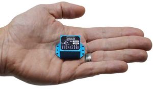
Higher rate, higher acceleration applications benefit from SWaP-C advantages of MEMS-based inertial systems.
Gladiator Technologies’ LandMark 007 inertial measurement unit (IMU) combines low noise, high range sensors and Velox high-speed output in a rugged IMU package measuring 0.7 inches square. With rate ranges up to 2000°/s and acceleration ranges as high as 200 g, the LandMark 007 IMU provides demanding, precision performance for a range of high dynamic, rugged applications.
Photo: Gladiator Technologies
All LandMark 007 IMUs feature Velox high-speed message timing to minimize digital message phase lag. They also include high-speed output data rates (up to 10 kHz) for measurement accuracy and flexibility.
These high-speed features are complemented by low-noise gyros with a gyro angle random walk (ARW) of <0.0035°/s/√Hz (0.15°/√hr) and low-noise accelerometers with a velocity random walk (VRW) of <6 mg/√Hz.
“The LandMark 007 IMU is uniquely designed to meet the industry’s need for a compact, rugged and high performance, cost-effective IMU. Extensive conditioning and testing ensure reliable, stable measurements for our customers with high dynamic applications,” said Eric Yates, Gladiator Technologies’ sales manager. “We are seeing strong interest in the LandMark 007 and LandMark 007X IMUs from applications which otherwise have been limited to highly specialized, and therefore expensive, IMU solutions.”
IMUs with less than or equal to 98 g linear acceleration range are designated as LandMark 007 IMUs. IMUs with greater than 98g linear acceleration range are designated as LandMark 007X IMUs. The LandMark 007 IMU is exported categorized as ECCN7A994 and the LandMark 007X is export categorized as ECCN7A103.
A LandMark 007 IMU development kit is available for set-up, configuration and data collection.
Hyperspectral imagery of U.S. East Coast. (Image: NOAA)
Raytheon will build the Geostationary Littoral Imaging and Monitoring Radiometer (GLIMR) sensor under a contract from the University of New Hampshire. GLIMR, NASA’s selected Earth Venture Instrument-5 investigation, will be NASA’s first hyperspectral imager in geostationary (GEO) orbit.
Hyperspectral imaging collects and processes information from across the electromagnetic spectrum including visible light, infrared and ultraviolet frequencies to create a highly detailed view of physical and biological conditions in coastal waters.
The instrument will provide high-sensitivity, high-spatial and high-temporal resolution measurements of coastal and ocean ecosystems in the Gulf of Mexico, parts of the southeastern U.S. coastline and the Amazon River plume.
Decision-makers will use the GLIMR data to respond rapidly to natural and manmade coastal water disasters, such as harmful algae blooms and oil spills. It will also help improve the coastal ecosystem’s sustainability and resource management.
“GLIMR will collect the sharpest and most colorful view of physical and biological conditions in coastal waters ever seen from GEO,” said Jeff Puschell, GLIMR instrument scientist and principal engineering fellow at Raytheon Space Systems. “A hyperspectral imager is essential technology to capture new insight about our changing coastal ecosystems.”
The University of New Hampshire is NASA’s lead organization for the GLIMR contract. The instrument will launch aboard its host spacecraft in the 2026-2027 timeframe. Its data will be available to scientists, researchers and educators around the world.
SenseFly, a drone solutions provider, will be demonstrating its drone solutions at Intergeo 2019, which will take place Sept. 17-19 in Stuttgart, Germany.
According to the company, visitors to its booth will be able to explore the flexibility of senseFly’s eBee X drone and its role in optimizing GIS and surveying workflows to achieve high quality outputs, such as centimeter-precise 3D point clouds, orthomosaics and digital surface models.
Attendees will be able to learn about the range of payloads and software solutions the eBee X platform can be used with, including the senseFly Aeria X, senseFly Duet T, senseFly S.O.D.A., senseFly S.O.D.A. 3D, MicaSense RedEdge-MX and Parrot Sequoia.
The senseFly team will also be hosting a series of Meet the Experts sessions on-stand featuring guest speakers and demos from senseFly partners such as Pix4D, ALLNAV and Harxon. The 10-minute talks will be followed by Q&A sessions.
“Our expert team also enables us to deliver the knowledge and insight our users need to navigate the changing landscape as drone technology continues to garner greater public and legislative attention worldwide,” said Gilles Labossière, CEO of senseFly. “Our customers’ needs are constantly evolving, and it’s vital for us to ensure that our products and solutions are as dynamic and versatile as they are to meet their unique and complex challenges.”
SenseFly’s can be found at booth B3.078, Hall 3, at Intergeo 2019.
A link to the live event will be sent to you two hours before the event. Your personalized event URL will be automatically generated by the ON24 system. To ensure receipt of the email, please whitelist this email address by adding it to your contacts: [email protected].
This presentation will begin on at 1 p.m. EDT / 10 a.m. PDT on Thursday, Sept. 12.
Audience members may arrive 15 minutes prior to live time. If you have any questions, please contact event producer James Webb at [email protected] or digital media manager Allison Barwacz at [email protected].
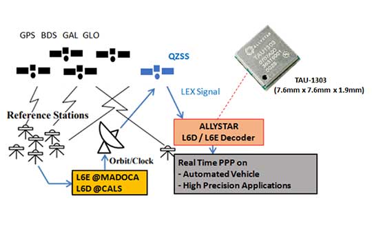
Allystar Technology Co. has launched its QZSS L6 decoder technology in module TAU-1303, which supports tracking the QZSS signals L6D (CLAS) and L6E (MADOCA).
The Quasi-Zenith Satellite System (QZSS) satellite positioning system is operated by Japan as complementary to and an augmentation for GPS. The four satellites in the system broadcast the L6 signal, including L6D and L6E.
CLAS — the Centimeter-Level Augmentation Service — is provided through the L6(D1) signal, and the experimental augmentation service with MADOCA (Multi-GNSS Advanced Demonstration tool for Orbit and Clock Analysis) is provided through L6(D2) signal.
For QZSS, which will be fully operational in the future, Allystar’s latest solution can decode the corrections data broadcast from L6D and L6E signals, and assist developers in applying the centimeter-level accuracy by PPP-RTK algorithm with the correction data, according to Justin Yang, Allystar product manager.
Within its 7.6 x 7.6-millimeter tiny size, the TAU-1303 module provides six dedicated tracking channels to support tracking L6D and L6E at the same time.
For professional applications, the TAU1303 comes with built-in support for standard RTCM Protocol (MSM) and Proprietary Protocol, supporting 2,000 bits per second QZSS L6 raw data output directly for third-party integration and application.
CLAS on L6D channel provides the following error corrections: satellite clock, orbit, code bias, phase bias ionospheric delay and tropospheric delay. MADOCA on L6E channel provides the following error corrections: satellite clock, orbit, code bias and phase bias.
Allystar TAU-1303 offers superior performance thanks to an on-board 26-MHz temperature-compensated crystal oscillator (TCXO) and a reduced time to first fix because of its dedicated 32-KHz real-time clock oscillator. Based on 40-nanometer manufacturing processes of the Cynosure III GNSS chipset, the TAU-1303 has very low power consumption of less than 40 mA at 3.3V.
Engineering samples are available.
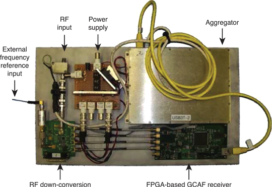
How Allystar’s QZSS L6 Decoder TAU1303 operates. (Diagram: Allystar)
Teledyne Optech’s new compact lidar sensor, the CL-90, is available for purchase through its first integration partnership with Lidar USA.
For more than 20 years, Lidar USA has been building UAV sensor systems and has sold thousands of systems worldwide. Its ability to support numerous industries with cutting-edge integration makes them an ideal partner for Teledyne Optech’s compact lidar sensors, Teledyne stated in a press release.
Lidar USA’s products are used for surveying-related tasks ranging from topography work, to highways and land development. They are also used for agricultural work for forestry and plant growth, and have applications in archeology as well.
Teledyne Optech’s CL-90 sensor features exceptional canopy penetration for excellent ground coverage, higher downward point density for superior results in corridor/power line projects, long-range performance for maximum productivity at UAS ceilings and best-in-class data precision for tight-tolerance applications, the company said.
“Our customers face many challenging projects and they need tools that can deliver,” said Lidar USA CEO Jeff Fagerman. “Whether it’s greater range, more accuracy or better penetration of vegetation, using the new Optech CL-90 gives us the means of providing the tool to get the job done.”
Teledyne Optech Executive Vice President and General Manager Michel Stanier believes the partnership will help expand both companies’ global presence.
“Teledyne Optech is pleased to partner with Lidar USA to bring our compact lidar sensors to market,” Stanier said. “Lidar USA is a premier UAV solution provider. As a result, we are confident that their integration expertise and strong global market presence will provide the ideal platform to deploy the CL-90’s rich, unique feature set into the UAV marketplace.”
Lidar USA will be at Intergeo this year and can be found at ICS Foyer Stand 2 featuring a fully integrated CL-90 solution. Teledyne Optech will be featuring some of its new Compact Lidar suite of products this year at Intergeo Booth B3. 042 from September 17-19 in Stuttgart, Germany.
Topcon Positioning Group will be showcasing its vertical construction, construction management, and structural health and inspection technology at Intergeo 2019. (Photo: Topcon)
Topcon Positioning Group will be demonstrating its technology offerings across vertical construction, construction management, and structural health and inspection at Intergeo 2019.
Topcon will present its new building information modeling (BIM) technology at the show, which includes the Topcon vertical construction workflow. The Topcon vertical construction work flow includes the Laser Scanning Robotic Total Station GTL-1000, MAGNET Collage and ClearEdge3D Verity software.
According to the company, the full workflow is designed to offer a powerful instrument for single-operator layout and scan on a single set up. It will also be releasing new innovative digital layout solutions alongside the GTL-1000 to enhance the VC portfolio and widen the options available to customers for this critical task.
Topcon will also be showcasing its inspection, assessment and monitoring solutions, which are designed to keep infrastructure assets in operation by providing reporting tools for site engineers and monitoring structural health.
Topcon added that it will be demonstrating its GTL-1000 and accompanying software MAGNET and ClearEdge3D Verity at the show. Its booth will also feature interactive displays that will provide virtual looks at job sites.
“Productivity is a huge talking point in our industry, so this year at Intergeo we’re proving that Topcon is always one step ahead, working in partnership with the construction and infrastructure sectors to provide solutions and products to address the big issues,” said Ian Stilgoe, vice president of Geopositioning Europe at Topcon Positioning Group. “Whether it’s quicker, simpler verification, or smart inspection and monitoring of aging assets, the need for digital innovation is greater than ever.”
Topcon’s demonstrations will be taking place at its booth, F3.013, in hall 3.
A link to the live event will be sent to you two hours before the event. Your personalized event URL will be automatically generated by the ON24 system. To ensure receipt of the email, please whitelist this email address by adding it to your contacts: [email protected].
This presentation will begin on at 1 p.m. EDT / 10 a.m. PDT on Thursday, Aug. 22.
Audience members may arrive 15 minutes prior to live time. If you have any questions, please contact event producer Grace Rybak at [email protected].