Industry experts share how GNSS can be used for precision agriculture.
Vazquez
EUROPEAN SATELLITE SERVICES PROVIDER (ESSP)
Juan Vazquez Team Leader, EDAS Service Provision
Pass-to-pass accuracy is the key performance indicator to assess the precision of guidance systems, characterizing the short-term dynamic performance determined from off-track errors along the straight segment passes (error with respect to the desired path in the direction perpendicular to the tractor trajectory).
The results of the tests reported in this article, jointly performed by Topcon Agriculture and ESSP, confirm that EDAS DGPS corrections can support a wide range of precision agriculture applications and represent a real alternative for cereal farms, when located in the vicinity (at least up to 260 km away) of an EGNOS reference station, complementing the benefits that the EGNOS signal-in-space is already providing to a large number of agriculture users in Europe.
EFFIGIS GEO-SOLUTIONS
Nicos Keable-Vézina Director of Precision Agriculture
Thanks to artificial intelligence, variable-rate application of nitrogen has made great strides in recent years. Science has demonstrated that effective nitrogen management requires an array of technologies, including massive databases. Data is geospatial (positioning signal and satellite imagery enabling the identification of changes in nitrogen requirements), agronomic (mainly soil texture and seasonal weather), and economic (grain and nitrogen price).
To automate extraction and analysis of such data, combining very low-cost positioning technologies, satellite imagery and artificial intelligence is paramount. A democratized access to technology has led to the development of scientifically proven nitrogen prescribing platforms, among them FieldApex, that calculate the most profitable nitrogen rates and generate prescriptions in seconds without soil sampling. Further technological and platform integrations are likely to bolster such innovation.
Rioja
TOPCON AGRICULTURE
Julian Rioja Channel Development and Business Intelligence Manager
All tests were performed using Topcon receivers, vehicles and auto-steering systems. Two different Topcon guidance systems on board tractors ran simultaneously to assess the EDAS DGPS positioning performance with respect to the reference provided by a real-time kinematic (RTK) system. Hence, two independent positioning outputs were continuously available (the receivers were placed along the same longitudinal axis on the roof of the tractor):
RTK position: provided by the AGI-4 receiver fed by Topcon’s Hiper V RTK base.
DGPS position: provided by the AGI-4 receiver fed by the EDAS Ntrip service.
On board the tractor, two Topcon X35 consoles were each connected to one of the receivers. A Topcon AES-25 electric steering system was installed on the tractor so that the selected navigation input (RTK or EDAS DGPS) could be used to automatically guide the tractor along the defined reference pattern.
McClure
HEMISPHERE GNSS
John McClure Engineering Manager, Precision Agriculture
Precision agriculture is expanding the use of ISOBUS for CAN communication between a common terminal and implements, to reduce clutter in the cab. These virtual terminals now act as display and user entry for multiple applications including GNSS receivers and factory or after-market steering systems.
INS-aided GNSS solutions, typically using RTK or satellite-based correctors such as Atlas, provide time/position data for rate and section control and auto-steering. CAN-based NMEA 2000 is the commonly used receiver protocol for position data, replacing serial NMEA 0183.
All major tractor, agricultural equipment, and GNSS manufacturers attend regular “Plugfest” meetings, organized by the Agriculture Industry Electronics Foundation, to test interoperability of products and set common standards.
Smart CAN dongles are being developed to read sensors and control systems, supplying positioned data via telematics as the Big Data for real-time and post analysis.
By Alexander Rügamer, Daniel Rubino, Xabier Zubizarreta, Wolfgang Felber, Fraunhofer IIS, and Jan Wendel and Daniel Pfaffelhuber, Airbus Defense and Space GmbH
This work presents a new secure localization method that can be used for UAVs to obtain a new level of protection against hostile and unauthorized UAVs. While non-spreading code-encrypted (SCE) GNSS devices can be blocked, authorized UAVs using this method have unrestricted access to the non-spoofable and trusted SCE GNSS. The proposed method is to store short sequences of SCE PRN code chips on the user receiver before the mission.
The Precalculate & Process architecture. (Images: Fraunhofer IIS)
These SCE PRN code chips allow the user receiver to calculate at pre-defined points in time a secure and trustable SCE PVT position. Since no communication channel is required, this method mitigates the risk that hostile forces may try to jam the UAV’s radio control. Moreover, radio silence can be realized, which is beneficial or even required for some missions.
No dedicated security module required on the user terminal, no SWaP problems, no keying issues, no handling of controlled items on user side, no need for a communication link giving rise to the availability and radio silence issues, and no security issues due to the short SCE PRN code chip sequences valid only for the limited mission duration and inside a limited area.
Potential target markets for this method are police and special forces and other authorized users which are allowed to use certain SCE GNSS and would like to equip their UAVs with a secure, unspoofable positioning solution. Check out more information here.
Includes first draft of best practices for implementing GIS in elections.
Photo: iStock.com/YinYang
The National States Geographic Information Council (NSGIC) has released the first-year report of phase one of its Geo-Enabled Elections project, highlighting the project’s accomplishments in the first 12 months. These include completing a baseline assessment of how far states have come, to date, in terms of integrating geographic information systems (GIS) with electoral systems, as well as assembling a team of leaders and experts to help guide the project.
The project team has also facilitated conversations with a wide range of stakeholder groups, aimed at raising awareness of the importance of using geospatial technology to increase reliability and accuracy in elections.
The Geo-Enabled Elections project, phase one, runs from Oct. 1, 2017, to Sept. 30, 2019, with the aim to help strengthen electoral systems by supporting states in the adoption of GIS. Concretely, this means encouraging state governments to replace non-spatial “address file” systems with election precinct and voter data in a GIS format, leveraging that format’s inherent visual and analytical advantages.
The Geo-Enabled Elections project is partly funded by the bipartisan Democracy Fund Voice.
“During this first year, we’ve been encouraged to learn that while most voter data across the country is still kept in ‘address file’ tables, many state election directors are interested in the benefits that GIS can bring. Additionally, since most state governments have a geographic information officer (GIO) or equivalent on staff, the prospects for strengthening elections through the integration of GIS into electoral systems are very good,” said Dan Ross, NSGIC president and GIO for the State of Minnesota.
As part of the Geo-Enabled Elections project, NSGIC has been able to help build stronger connections between state officials responsible for the electoral system and state-level GIS subject matter experts, a critical first step towards the successful implementation of GIS in elections.
The organization, which is quickly becoming recognized as the center of expertise for how GIS can be deployed to strengthen electoral systems, also released the first draft of its best practices for how states may go about enhancing election accuracy using GIS. The five identified best practices are:
Convene a team of specialists
Collect and sustain a statewide voting unit GIS layer
Adopt and implement a statewide geocoding strategy
Assemble and provide best Available contextual GIS layers
Define and implement data validation processes
These draft best practices will be put to the test and further refined in five state-wide pilot studies taking place during the project’s second year. The best practices can be viewed in full as part of the first-year report.
NSGIC’s report also outlines the work that lies ahead for the project, as well as opportunities to impact geo-enabled elections in phase two of the project (pending funding).
Enhancements include flexible pricing and easier app deployment experience
Esri has implemented major changes to ArcGIS for Developers, providing an enhanced mapping experience that the company says is more accessible and affordable.
These changes include a new pay-as-you-go plan for all of Esri’s location-based services, a decrease in the price of routing transactions and a new commercial app deployment experience for developers, the company said.
ArcGIS for Developers. (Photo: Esri)
This new experience brings the power of mapping to all developers and provides greater simplicity and flexibility. Esri has introduced a new monthly payment structure for the Builder plan in its developer subscription. The Builder plan is now offered at a monthly subscription rate of $125.
Esri has also introduced a 10 percent discount on existing annual Builder plan subscriptions. Customers who currently have an annual Builder plan subscription can continue to pay annually or switch to paying monthly.
“In addition to our existing subscription plans, we have introduced a new pay-as-you-go model that enables developers to pay only for services and transactions that they use,” said David Cardella, Esri product manager for developer technologies. “Developers can now access dozens of different maps from our Living Atlas, store their data securely, route, and geocode, as well as create and deploy apps with much greater ease and efficiency.”
Esri has additionally included a commercial app deployment license in all paid developer subscription plans (Builder plan and higher) at no additional cost. The price of routing services has also been reduced from $4 to $0.50 per 1,000 routes. This price decrease is applicable to all ArcGIS users, including the developer community.
ArcGIS for Developers offers a full suite of developer tools and development resources to build mapping and analytics solutions to support business needs. Developers use ArcGIS APIs to create location-based web and native applications for desktop and mobile devices.
The new enhancements and changes now give developers greater freedom to build, manage, and deploy apps as quickly as possible by allowing them to use the specific tools they need, when they need them, priced to fit their individual needs.
Figure 1: Reflected signals in the local environment suffer different Doppler variations than the desired lineofsight signal. This means that the supercorrelator that is created for a given satellite broadcast couples strongly to the desired line of sight version of the signal, but attenuates any reflected signals arriving from different directions. (Figure: Focal Point Positioning)
The SGPS/SGNSS technology is a patent-protected suite of methods that provides software-based improvements to existing GNSS receivers. All methods within the software suite build upon a core technology called supercorrelation, which enables over a second of coherent integration while undergoing complex motions on low-cost platforms. The benefit is high sensitivity coupled with strong multipath mitigation capabilities, providing a high-accuracy and high-integrity positioning solution in traditionally difficult environments.
Many GNSS receivers perform a small amount of coherent integration, typically less than 20 milliseconds, and then optionally incoherently integrate over many hundreds of milliseconds to boost sensitivity if needed. The major problem with this approach is the resulting susceptibility to multipath interference. Incoherent integration destroys the phase information stored within the captured data before combining it, resulting in line-of-sight and non-line-of-sight signals accumulating within the same correlation peak, producing a distortion of the desired line-of-sight information. This distortion leads to erroneous codephase estimates, which in turn leads to erroneous position estimates.
Coherent integration can decorrelate signals arriving from different directions, but the degree of decorrelation depends on the user speed and the coherent integration time. Supercorrelator technology creates a clock-and-motion-compensated phasor correction sequence that provides over a second of coherent integration on low-cost consumer platforms. The outcome is signal tracking sensitivities down to nearly zero dBHz, combined with high multipath mitigation performance. Such long coherent integration times allow signals arriving from different directions to be separated out in the frequency domain, permitting new capabilities in anti-spoofing and 3D map-aiding methods by directly resolving GNSS angle-of-arrival using a single moving antenna.
Figure 2: The result of supercorrelation on positioning performance in the urban canyons of central San Francisco. The red line is a standard state-of-the-art vector tracking GPS solution, and the green line is the same positioning engine with supercorrelation processing enabled. (Image: Focal Point Positioning)
Traditionally, very long coherent integration times were not practical on consumer devices due to limitations of data modulation bits, crystal oscillator stability, and unknown (often complicated) receiver motion. Supercorrelation overcomes these limitations with signal processing and sensor fusion. Data modulation bits are not an issue for modern pilot signals, and for legacy signals they can be removed with a variety of methods, ranging from prediction or provision of the bits over a datalink, to stripping them directly with signal-squaring methods. Receiver motion can be inferred from inertial sensors mounted alongside the GNSS receiver, as is the case for smartphones and smartwatches, or can be modeled using multi-hypothesis methods. Low-cost crystal oscillators cause phase instabilities which traditionally reduce coherent integration time, but can also be accounted for by multi-hypothesis testing and by joint estimation processes across multiple channels.
A decade ago, consumer GNSS receivers were typically an ASIC or similar hard-wired design. Modern designs incorporate a front-end correlator bank which may or may not be reprogrammable, feeding into a DSP stage which handles all tracking and navigation processing from the DLL, PLL, FLL stages onwards. The flexibility of reprogramming the code running on the DSP stage permits existing GNSS chipsets to be easily upgraded to support supercorrelation, without needing to design and fabricate a new receiver.
Focal Point aims to have S-GNSS enabled chips by early 2020, with licensing opportunities available from summer 2019 onwards.
TDK Corporation has introduced a new line of automotive high-accuracy devices from InvenSense, a TDK group company. The line includes the IAM-20680, IAM-20680HP, IAM-20380 and IAM-20381.
According to the company, its family of automotive solutions can help enhance the absolute position of a vehicle in GNSS- and GPS-denied environments. They also can be interchanged without the need to redesign hardware or software.
The IAM-20680 is a 6-axis qualified sensor that features 16-bit accelerometers and 16-bit gyroscopes. The IAM-20680HP is a high-performance version of the IAM-20680 that features high gyroscope and offset thermal stability. The IAM-20380 is an automotive-qualified gyroscope fully compatible with a 3-axis automotive accelerometer and an automotive-qualified 6-axis device. The IAM-20381 is an automotive-qualified 3-axis accelerometer fully compatible with a 3-axis automotive gyroscope and an automotive-qualified 6-axis device.
The IAM-20680HP and IAM-20680 can be used to improve estimates of the position, direction and speed of a vehicle when the satellite signal is deteriorated or non-existent, as well as to improve the quality of the position estimation when the satellite signal is strong, the company said. Customers can design with the IAM-20680 and can use the IAM-20680HP when navigating in high temperature environments or for systems where cooling is weak or unavailable.
If cost efficiency is an important consideration, the company recommends the IAM-20380 or IAM-20381.
“With the increased usage of location services for turn-by-turn navigation, the importance of not losing your GPS or GNSS signal due to environments like tunnels, parking garages and urban canyons is paramount,” said Amir Panush, vice president and general manager of the Motion and Pressure Business Unit at TDK. “With a full family of InvenSense product offerings that are automotive qualified, OEMs have a plethora of options to differentiate the user experience and supply consumers with more reliable navigation solutions.”
The IAM-20680 and IAM-20680HP are also designed into the new InvenSense Coursa Drive software solution, an inertial-aided positioning software solution for autonomous vehicle platform developers.
In April 2018, the Civil GPS Service Interface Committee (CGSIC) announced the Department of Homeland Security release of the memorandum titled “U.S. Owners and Operators Using GPS to Obtain Time,” which is intended to provide an understanding of the possible effects of the April 6, 2019, GPS Week Number Rollover on Coordinated Universal Time derived from GPS devices.
GPS users should review this memorandum and be aware of the potential impacts to their equipment when the GPS Week Number rolls over to 0 on April 6, 2019 / April 7, 2019.
If you have questions about how your equipment may be impacted by the GPS Week Number rollover, we recommend you contact your equipment manufacturer.
A roundup of recent products in the GNSS and inertial positioning industry from the January 2019 issue of GPS World magazine.
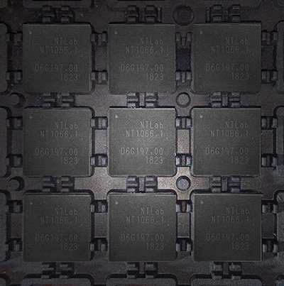
OEM
RF front-end
Application-specific integrated circuit (ASIC) FOR GNSS
Photo: NTLab
NT1066 is a four-channel RF front-end ASIC (three wideband IQ and one narrowband IQ) that covers all GNSS (GLONASS, GPS, Galileo, BeiDou, QZSS, NavIC) signals at all frequency bands, so users benefit from all the advantages of acquiring multiple system simultaneously. Channels A, B and C are designed with single-conversion low-IF architecture, individually programmable and intended to receive L1, E1, B1, E6, B3, L2, L3, B2, L5 and E5 in various combinations. IQ and image suppression modes are available. Channel D is dedicated to the S band of NavIC or L2, L3, L5 bands of GNSS and has zero-IF architecture. Combining channel D with channels A, B and C makes it possible to effectively eliminate ionospheric distortion using the large signal base of NavIC between the L5 and S bands. Alternatively, channel D can be software-reconfigured “on a fly” to receive real-time correction data transmitted over FM, VHF and UHF bands.
For smartwatches, fitness trackers and smartphones
Image: Bosch
The BHI160BP is a position tracking smart sensor for consumer wearables that uses integrated inertial sensors to improve GPS location tracking. When used with a GPS or GNSS module, it enables users to take advantage of pedestrian position tracking with up to 80% saving in system power consumption compared with a typical GNSS-only solution, without compromising on accuracy. The BHI160BP tracks a person’s position by intelligently applying an inertial-sensor-based algorithm for pedestrian dead reckoning. To maintain accuracy, it calculates the user’s relative location based on data collected from the inertial sensors and then recalibrates itself every few minutes to obtain the absolute position provided by the GNSS/GPS module. This means that the GNSS/GPS module can be kept in sleep mode for most of the time, which drastically reduces a device’s power consumption and extends its operating time.
The SL869T3-I GNSS module combines GPS with India’s NavIC (IRNSS) navigation system and the country’s satellite-based augmentation system SBAS known as GAGAN. The SL869T3-I module enables the creation of high-performance position reporting and navigation solutions. It complies with Automotive Industry Standard 140 (AIS-140) — an Indian government mandate that requires the use of NavIC for vehicle location tracking devices in all public transportation vehicles, effective in April.
Technical information for defense and aeronautics applications
The Rohde & Schwarz Navigation and Guidance Solutions Learning Center now includes the latest Rohde & Schwarz solutions for GNSS testing. Updated material includes application brochures, white papers, articles, technical documents, training videos and products. Rohde & Schwarz provides accurate, flexible, high-performance test solutions, from design, development, calibration and production to operational maintenance for ground-based systems and advanced hybrid constellation simulations for GNSS systems. The navigation learning center also describes company products, including GNSS signal simulators.
The X-Survey antenna is a 4-in-1 OEM antenna for both navigation and communication in surveying applications. It provides standard Wi-Fi, Bluetooth and 4G, plus multiple constellation signal reception for GNSS positioning. The high-gain and wide-beamwidth GNSS antenna features a multi-point feeding technology, ensuring a high phase-center stability and positioning accuracy. Moreover, the array-arranged 4G antenna enables more stable signals and longer communication distance at 360-degree direction, increasing the overall machine efficiency over conventional antennas. The X-Survey antenna provides high isolation among each antenna to prevent self-interference, improving real-time kinematic (RTK) system compatibility. RF coaxial connectors are designed for plug-and-use, keeping high efficiency and lowering the impact of electromagnetic interference.
Mirrors capabilities of desktop version of global mapper
Image: Blue Marble
Version 20 of the Global Mapper Software Development Kit (SDK) is now available, along with the accompanying Lidar Module SDK. The developer’s toolkit provides software engineers with the means to embed the latest geospatial technology into custom applications.Highlights include dramatically improved vector data performance in both the 2D and 3D environments, updated 3D mesh rendering with colors now displayed in the 2D view, and faster display and export of online tiled datasets. The Global Mapper GIS application can display, convert and analyze virtually any type of geospatial data. The Global Mapper SDK and Lidar Module SDK provide software developers with a toolkit for accessing much of this functionality from within an existing or custom-built application.
The ZALA 421-08M and ZALA 421-16E Artic UAVs are suited for operation at freezing temperatures, making it possible to carry out surveillance operations and regularly monitor the ice. Its GIRSAM alternative navigation system was developed for navigation of UAVs in the suppression or the absence of GPS or GLONASS signals. The ZALA Arctic’s capabilities facilitate oil and gas extraction planning in areas where accurate weather and ice situation forecasts are required.
E-Drone Zero is a long endurance quadcopter managed by an advanced artificial-intelligence-powered operating system. The use of hydrogen fuel cells as the drone power source provides improved flight-time, less downtime due to quick refuelling, and increased payload capabilities. Advanced security is provided via NATO-validated military-level encryption. Additional safety features include computer vision assisted obstacle avoidance and various failure management features. Besides surveillance and security, e-Drone Zero is suitable for demanding survey, mapping and inspection tasks.
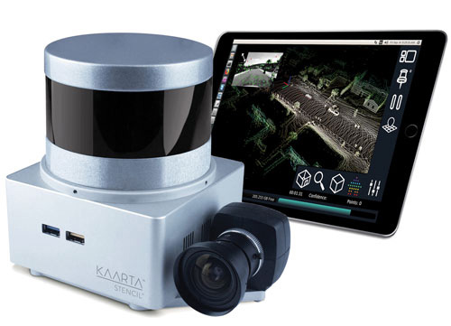
The Stencil 2 improves mapping accuracy and workflow with a new user interface compared to the original Stencil, as well as GNSS localization, upgraded hardware, confidence metrics and enhanced software intelligence. Stencil 2 ships with an iPad to access operations and view real-time scanning on the fly. It records GNSS data for use in loop closure to georegister and geolocate datasets, correcting for drift and improving the fidelity of large area scans. Kaarta offers an optional GNSS kit with Emlid Reach RS+ RTK GNSS receiver and custom mounting bracket. Alternatively, Stencil 2 integrates with other NMEA 0183-compliant GNSS systems.
Now type-approved by the U.S. National Marine Fisheries Service (NMFS) Office of Law Enforcement (OLE), the Addvalue iFleetONE-VMS provides commercial fishing vessels with a technologically advanced vessel monitoring system that satisfies regulatory requirements to routinely and securely report GPS positioning. The Addvalue iFleetONE-VMS, with its broadband capability, will enable fisheries management officials, biologists, researchers, analysts and NMFS Law Enforcement to have a cost-effective and suitable platform for applications that previously had been severely limited by available technologies.
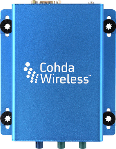
The MK5 On-Board Unit (OBU) is a fifth-generation low-cost, rugged module that can be retrofitted to vehicles for aftermarket deployment or field trials, and can also serve as a design reference for automotive production. The MK5 exchanges data at high speeds over extended distances, providing quick reaction times to potential hazards and safety-critical scenarios. Features include a dual IEEE 802.11p radio; a powerful processor running Cohda software applications; a GNSS receiver with lane-level accuracy; integrated security; hardware acceleration; and NXP chips with Cohda firmware. It supports DSRC (IEEE 802.11p), Wi-Fi (802.11a/b/g/n) wireless standards.
The SmartDrive SR3 and SR4 platforms provide a unified video and telematics data stream of time, location and driver and vehicle performance for third-party applications. Its single-box architecture and unified data stream eliminates redundancy across hardware, cellular connectivity, GPS modules, connections to the ECU and cabling. It also provides data alignment across the applications, unlocking new fleet performance insights and eliminating problematic data discrepancies.The platform provides analytics powered by SmartDrive SmartIQ; Geotab tracking, which delivers real-time and historical visibility to location, speed and geofencing information; Geotab regulatory compliance, including hours of service, driver vehicle inspection reports, International Fuel Tax Agreement (IFTA) recording and tax reports; and access and integration to Geotab Marketplace partners.
In his new book No One at the Wheel: Driverless Cars and the Road of the Future, Transportation expert Samuel I. Schwartz (who coined the term “gridlock”) describes how the driverless vehicle revolution will transform highways, cities, workplaces and laws across the globe. Every major car maker in the U.S., and abroad is working on bringing autonomous vehicles to consumers. The fleets are getting ready to roll and nothing will ever be the same; this book discusses what the future has in store. 272 pages, ISBN: 1610398653.
GPS Control Segment Sustainment II (GCS II) contract continues the modernization of the GPS Operational Control Segment (OCS).
The U.S. Air Force has awarded Lockheed Martin the GPS Control Segment Sustainment II (GCS II) contract to continue to sustain and further modernize the GPS constellation’s ground control system through 2025.
This is a follow-on contract to Lockheed Martin’s current GCS contract, awarded in 2013.
Under the GCS II contract, the continued upgrade of the GPS Architecture Evolution Plan Operational Control Segment (AEP OCS) will allow GPS’ legacy ground control system to support GPS III satellite on-orbit operations, developed under the GPS III Contingency Operations (COps) program.
SpaceX’s Falcon 9 rocket orbited the first GPS III satellite on Dec. 23, 2018. (Photo: SpaceX)
COps will enable the AEP OCS to support the positioning, navigation and timing missions of the Air Force’s new GPS III satellites, which began launching in December 2018.
In addition, GCS II will sustain the operational M-code capability being deployed in 2020 that is in development under the M-code Early Use (MCEU) contract. Operational M-code is a critical warfighter capability to support missions in contested environments.
Under the GCS contract, Lockheed Martin executed numerous engineering modifications to the OCS, including:
the COTS Upgrade 3(CUP3)/Ground Antenna Air Force Satellite Control Network (AFSCN) Interface Technology Refresh (GAITR) upgrade
the Remote Site COTS Network (RSCN) project
the GPS Information Protection Reinforcement (GIPR) project
the COTS Upgrade #2 (CUP2) project
Red Dragon Cybersecurity Suite (RDCSS).
These projects modernized the infrastructure, improved the cyber posture and added mission capability. The GCS II contract continues that commitment to evolving the OCS to address today’s mission needs.
Under GCS II, LM will continue to manage the technical baselines for the OCS and GPS Information Network (GIN) and regularly procure, develop, fabricate, integrate, test and install software and hardware modifications into the GPS operational baseline. Focus areas will be performing a technical refresh of the GIN and increasing the resiliency of the OCS.
“Lockheed Martin’s experience integrating GCS projects as well as the system engineering and software integration performed on GPS III Contingency Operations (COps) and M-Code Early Use (MCEU) position us well to deliver GCS II,” said Maria Demaree, vice president/GM Mission Solutions for Lockheed Martin Space. “We look forward to supporting the Air Force as it deploys the next generation GPS III satellites and their new capabilities for our warfighters.”
CityMapper is a hybrid airborne sensor combining vertical and oblique imagery with 3D laser scanning designed for 3D city modeling and urban mapping.
Using the CityMapper, Bluesky was able to capture parts of London, Manchester and Birmingham as well as Brighton, Bristol, Cambridge, Norwich, Nottingham and Oxford. Bluesky intends to increase its coverage by capturing additional towns and cities across the U.K. and Ireland in 2019.
St. Paul’s Cathedral in London captured in lidar point-cloud data. (Image: Bluesky)
According to Bluesky, this is the first time the technology has been used commercially in the UK to this level. The captured city data is available from Bluesky and Leica Geosystems, part of Hexagon, in its constituent components of vertical orthorectified aerial imagery, oblique photographs and lidar point cloud data. Plans are in place to also include the imagery in the HxGN Content Program.
The combination of multiple survey-grade cameras and lidar enables the simultaneous capture of data for the automatic creation of highly accurate and detailed citywide 3D models, with one sensor, according to Bluesky.
Previous 3D models have either been prohibitively expensive for use across larger areas or of insufficient detail or accuracy. The CityMapper sensor enabled efficient, cost-effective capture of highly detailed and accurate data, and could make possible widespread use of 3D models possible.
The CityMapper sensor is designed for 3D city modeling and urban mapping. (Photo: Leica Geosystems)
CityMapper includes a traditional vertical camera as well as survey-grade oblique cameras. The sensor also includes high-performance lidar technology to accurately collect elevation data even into the shadows, which are common in urban environments and make photo-based data collection difficult.
The CityMapper sensor also collects color infrared data, which can be used to aid greenspace mapping and vegetation studies.
Applications of the new Bluesky 3D models are expected to include urban planning, line-of-sight analysis, new development visualizations and environmental modeling, as well as potentially 3D fly throughs and virtual reality experiences. Early adopters of the data include architects, planning consultants and other map publishers.
DJI Phantom 4 Pro with Loki PPK system. (Photo: GeoCue)
GeoCue Group (via its wholly owned AirGon subsidiary) has completed the integration of the DJI Phantom 4 Pro RTK (P4R) into its AirGon Sensor Processing Suite (ASPSuite).
ASPSuite is a post-processing solution for GeoCue’s Loki direct geopositioning system for DJI and other manufacturer’s drones.
ASPSuite enables integration of the P4R with third-party L1/L2 GNSS base stations such as systems from Septentrio, Leica, Trimble, Topcon, CHC and others in a high accuracy post-process kinematic (PPK) workflow.
In addition to PPK processing, ASPSuite includes support for options often required in engineering-grade surveys such as:
vertical transforms (such as ellipsoid to country-specific geoids)
creation of and transformation between collection datums and local coordinate systems (site calibration)
application of antenna static and dynamic lever arm corrections
full support for Loki direct geopositioning systems.
The DJI D-RTK-2 base station (optionally available) for the P4R can only be used in RTK mode, and then only if it is being sited on a known location. The D-RTK-2 does not currently allow access to an observation file, preventing it from being stationed using an online positioning service such as OPUS, AUSPOS, Canadian Geodetic Survey services and so forth. An additional consideration in the integration into ASPSuite is that professional surveyors already have the survey kit that they need incorporated into this workflow.
GeoCue is offering camera calibration services for the P4R for customers who wish to do minimal or control-free high-accuracy mapping projects (the DJI “calibration” is an image de-warping algorithm, not a proper photogrammetric calibration). A test of a GeoCue-calibrated P4R using an OPUS-positioned base station and ASPSuite achieved about 4-cm horizontal and 5-cm vertical network accuracy (RMSE) with no ground control points.
The Iowa Department of Transportation (DOT) has integrated eX² Technology’s Truck Parking Information Management System (TPIMS) into its operations.
According to eX² Technology, the Iowa TPIMS solution, “Trucks Park Here,” is among the first statewide networks to be implemented in the Midwest. Operational usage began on Jan. 4.
An eX² Technology ground truthing camera installed on a water tower took this photo overlooking the I-80 Truckstop, the world’s largest truckstop. This is one of the sites integrated into Iowa’s Trucks Park Here TPIMS network. (Photo: eX² Technology)
Iowa’s Trucks Parks Here provides real-time information on available truck parking spaces for public rest areas, private truck stops and other privately owned facilities along Iowa’s I-80, I-29, I-35, I-235 and I-380 corridors, said eX² Technology. In addition, the system connects to 41 truck parking facilities, including 24 public rest areas, 15 privately owned truck stops, one privately owned restaurant and one privately owned casino.
The components of the Iowa TPIMS solution are fully automated with a remote network monitoring system that provides operational, health and accuracy alerts and relies on a hybrid of detection methods to accurately assess available truck parking spaces, including screenline and space occupancy technologies such as in-ground sensors and video analytics, eX² Technology added.
“We’re really pleased with how seamless the project implementation went and the overall effectiveness of the solution,” said Kyle Hildebrand, vice president of project development at eX² Technology. “We leveraged our success with the Colorado DOT TPIMS deployment to deliver a reliable and economically feasible solution that was right for Iowa. In the process, we perfected a standardized, off-the-shelf product that we can implement quickly throughout other states across the country.”
The Iowa project was part of a larger Mid America Association of State Transportation Officials (MAASTO) initiative that was funded in part through a $25M federal Transportation Investment Generating Economic Recovery grant awarded to a group of eight partnering states — Iowa, Indiana, Kansas, Kentucky, Michigan, Minnesota, Ohio and Wisconsin.
The Iowa Department of Transportation received $3.4 million in MAASTO grant dollars to fund the $4 million Trucks Park Here project with a portion of the overall costs covering three years of systems maintenance and operations.
“eX² Technology took an innovative and cost-conscious approach to designing Iowa’s TPIMS solution,” said Phil Mescher, a transportation planner with the Iowa Department of Transportation. “eX² incorporated existing pole and site infrastructure into the TPIMS design when possible, used low power consumption and solar powered solutions and worked independently to procure non-traditional parking site facilities to increase the overall number of truck parking spaces within the TPIMS network.”