Category: Uncategorized

  • Antennas: The key to accuracy for high-precision applications

    Antennas: The key to accuracy for high-precision applications

    New developments in antenna technology empower the final positioning solution with better accuracy and reliability. Leading experts discuss the technology advances producing greater user benefits.

    The increasing prevalence of both intentional and inadvertent jamming, new wider bandwidths, and the significance of antenna phase-center variation all bring changes to the dynamic and evolving antenna sector.


    Javad Ashjaee (Photo: Javad GNSS)
    Javad Ashjaee (Photo: Javad GNSS)

    Javad Ashjaee

    President & CEO, JAVAD GNSS

    Advanced filtering techniques enable our antennas to defend against jammers and spoofers and to inform users with the details of these intrusive actions when they are detected.

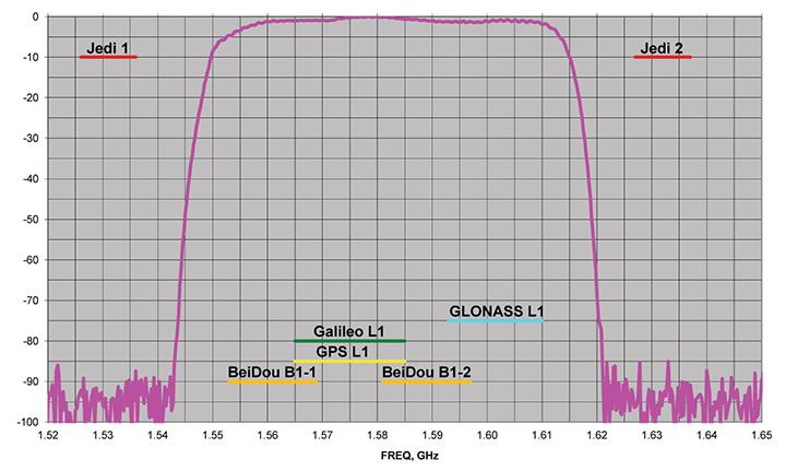
    Near-Band Interference. The J-Shield is a robust filter in our antennas that blocks out-of-band interference, in particular such signals that are near the GNSS bands like the LightSquared/Ligado signals. The graph below shows the protection characteristics of the J-Shield filters. It has a sharp 10-dB/KHz skirt that provides up to 100 dB of protection. It makes the precious near-band spectrums available for other usages and protects GNSS bands now and in the future.

    In-Band Interference. Our in-band protection digital filter protects against in-band interference like harmonics of TV and radio stations when you get close to them, or against illegitimate in-band transmissions. Our in-band interference protection is based on the 16 adaptive 80th-order filters. Advanced interference mitigation (AIM) filters can be combined in pairs for complex signal processing. This filter can simultaneously suppress several interference signals.

    Graph: Javad GNSS
    Graph: Javad GNSS

    The 16 finite impulse response (FIR) AIM filters can be combined in any number in chain. Each filter is a 255-order FIR filter. It can be used to suppress the stationary interference signal in programmable area (compare with adaptive AIM-filter) or for spectrum shaping. To have more suppressing areas or more aggressive suppressing, one can combine FIR AIM serial.


    Neil Gerein, Portfolio Manager, NovAtel. (Photo: NovAtel)
    Neil Gerein, Portfolio Manager, NovAtel. (Photo: NovAtel)

    Neil Gerein

    Director, Product Management, NovAtel

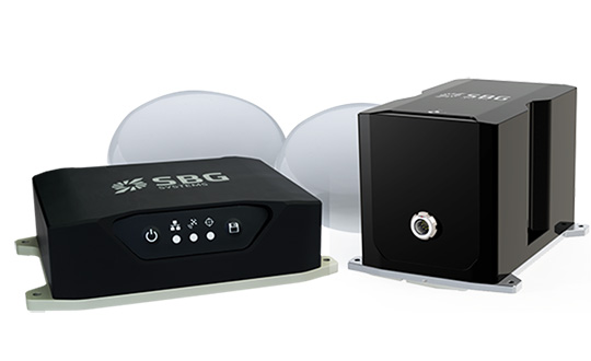
    At NovAtel we often say, “accuracy is addictive,” and to meet increasingly demanding accuracy and reliability requirements it is vital to concentrate on the antenna. After all, the antenna is the first in a long chain of key technologies that the GNSS signals must pass through to create a position, navigation and timing solution.

    All modern GNSS transmit on multiple frequencies, with wide bandwidth signals, requiring antenna elements and integrated low noise amplifiers (LNAs) that operate across these frequencies. The challenge is to design the antenna element and LNAs for symmetric radiation patterns across all frequencies while minimizing multipath, phase center offset (PCO) and phase center variation (PCV). The result is better carrier-phase measurements, and therefore more accurate solutions in real-time kinematic (RTK) and PPP applications.

    Photo: NovAtel
    Photo: NovAtel

    Since 2016 the Radio Equipment Directive (RED) has been in effect, and all GNSS receiver systems sold into the European Union must be compliant to the standard, including adjacent-band compatibility and spurious emissions testing. RED compliance is an end-to-end system test, where the filtering within the antenna must be analyzed in concert with the filtering capabilities of the connected GNSS receiver to meet the requirements. The antenna performance therefore becomes critical to any GNSS receiver system that is intended to be sold within the EU.


    Gyles Panther, president and CTO, Tallysman Wireless. (Photo: Tallysman)
    Gyles Panther, president and CTO, Tallysman Wireless. (Photo: Tallysman)

    Gyles Panther

    President and Chief Technical Officer, Tallysman

    A fact often not appreciated is that the performance of a GNSS antenna is commonly the limiting factor in system accuracy. Digital signal algorithms in the receiver are helpful, but if the signal delivered by an antenna is less than optimum, the receiver cannot compensate.

    Precision GNSS systems typically rely upon resolved wavelength ambiguity measurements, combined with ephemeris and clock corrections to determine signal time of flight. In real-time kinematic (RTK) and precise point positioning (PPP) receivers, the basis for this measurement is phase locked tracking of received satellite signals. Thus an over-arching measure of antenna performance in the specific application conditions is the proportion of the time that phase lock is maintained by the receiver.

    The VeraChoke GNSS antenna. (Photo: Tallysman)
    The VeraChoke GNSS antenna. (Photo: Tallysman)

    All this provides for an unprecedented level of accuracy, with precision antennas now more akin to the ends of a tape measure than providing a simple GNSS “fix.” To this end, key parameters include a best possible G/T ratio, high multipath rejection, excellent axial ratio, high front-back ratio and minimal phase-center variation (PCV), all with high uniformity in the azimuth — altogether a very demanding design task.

    Combining these parameters to provide exquisite accuracy, the Tallysman VC6100 choke ring antenna has less than 1 millimeter PCV when combined with absolute calibrated corrections data, whilst the lower cost VP6000, with its less complex installation, can be used without corrections data and still be within a millimeter or two of the truth compared to its more precise cousin.

  • STMicroelectronics to acquire majority stake in silicon carbide wafer manufacturer Norstel AB

    Global semiconductor company STMicroelectronics has signed an agreement to acquire a majority stake in Swedish silicon carbide (SiC) wafer manufacturer Norstel AB.

    After closing the deal, ST will control the entire supply chain for a portion of its SiC devices at a time of constrained global capacity and positions itself for a significant growth opportunity, ST said in a press release.

    ST will acquire 55 percent of Norstel’s share capital, with an option to acquire the remaining 45 percent subject to certain conditions, which, if exercised, will result in total consideration of $137.5 million, funded with available cash.

    “ST is the only semiconductor company with automotive-grade silicon carbide in mass production today,” said Jean-Marc Chery, president and CEO of STMicroelectronics. “We want to build on our strong momentum in SiC, both in volume and breadth of applications for industrial and automotive, targeting continued leadership in a market estimated at more than $3 billion in 2025.

    “The acquisition of a majority stake in Norstel is another step forward strengthening our silicon carbide ecosystem: it will boost our flexibility, improve yield and quality, and support our long-term silicon carbide roadmap and business.”

    Norstel, headquartered in Norrkoping, Sweden, was founded in 2005 as a spinoff of Linköping University. It develops and manufactures advanced 150-mm silicon carbide bare and epitaxial wafers.

  • Durham public works uses Nearmap to manage massive city growth

    Nearmap high-resolution aerial image of Durham, North Carolina, photographed Jan. 15. (Photo: Nearmap)
    Nearmap high-resolution aerial image of Durham, North Carolina, photographed Jan. 15. (Photo: Nearmap)

    Location content provider Nearmap has partnered with the city of Durham, North Carolina, to help it manage infrastructure projects.

    The city’s Public Works Department uses Nearmap’s high-resolution imagery to aid in managing all infrastructure data for the city, including the city’s $16 million a year Stormwater Utility Fund.

    “Having access to imagery back to 2014, we’re able to go back in time during the thrust of development and monitor it forward,” said Edward Cherry, Durham’s GIS administrator. “With Nearmap, we’ve been able to update development processes and policies to support the revitalization of the downtown district as well as rapid city growth.”

    After using satellite imagery systems with low resolution and infrequent captures, Cherry and his staff of 14 GIS professionals determined the city needed superior mapping imagery.

    Captured every six months at a 2.8-inch ground sample distance, Nearmap supplies Durham with clear images that are up-to-date and accessible through web-based cloud servers, the company said.

    The result is better monitoring of pavement conditions; time savings and documentation of road repairs; more detailed maps of city riparian zones; and accurate and detailed customer billing.

  • Averna’s latest development tools accelerate IoT deployment

    Averna’s latest development tools accelerate IoT deployment

    Image: Averna
    Image: Averna

    Averna has launched a series of development tools that enable the real-time monitoring of assets.

    The Averna ConnexThing Toolkits enable customers to quickly connect new and existing manufacturing test assets to PTC’s ThingWorx Industrial IoT Platform.

    Each toolkit targets a specific programming language or test sequencer to accelerate the implementation and deployment of an internet of things (IoT) solution with ThingWorx.

    The ConnexThing Toolkit for NI TestStand, which is available for download now, streamlines the connection between TestStand’s ready-to-run test management software and ThingWorx’s innovative end-to-end IoT platform. It comes complete with templates, data shapes, widgets and dashboard examples that easily link test stations.

    The ConnexThing Toolkit for NI TestStand:

    • accelerates integration of ThingWorx with TestStand
    • enables easy monitoring of test stations and asset management using the configurable ThingWorx dashboard tool
    • orchestrates bi-directional communication
    • provides guidance for clean code and architecture.

    “The Averna ConnexThing Toolkit is the first in a series of new operational technology (OT) solutions designed to help clients gain insight on manufacturing and test processes and deploy Smart Connected Operations,” said Jean-Levy Beaudoin, VP Platforms & Innovation for Averna. “By leveraging the power of PTC’s ThingWorx Industrial IoT Platform together with our test assembly automation and machine vision expertise, Averna is uniquely qualified to help organizations achieve their digital transformation, enabling further productivity and quality improvement.”

    “PTC is pleased to have Averna in the PTC Partner Network, allowing for their recognized quality and test expertise to be made readily available to ThingWorx customers,” said JP Provencher, vice president of manufacturing strategy and solutions at PTC. “The ThingWorx extensions they have built help manufacturing companies improve test and quality processes by making them connected, real-time, predictive, and augmented.”

    The Averna ConnexThing for NI TestStand is available to download now as a free 90-day trial, directly from the PTC Marketplace or Averna website.

  • US National Data Infrastructure’s grade rises from C to B-

    COGO releases 2018 Report Card on the U.S. National Spatial Data Infrastructure (NSDI)

    The U.S. National Data Infrastructure (NSDI) is improving with broader expertise, according to an assessment by the Coalition of Geospatial Organizations (COGO).

    The NSDI’s grade rose from a C in the 2015 Report Card to a B- in the 2018 Report Card. The improved overall grades reflect a broadened base of experts and government organizations involved in the assessment, as well as an expanded set of assessment metrics, according to COGO.

    The report card uses a letter grading system to depict the status and condition of the nation’s geospatial infrastructure. The assessment measures NSDI’s ability to meet future geospatial data, based on address, cadastral, elevation, geodetic control, government units, hydrography, orthoimagery and transportation themes.

    Chart: COGO, from 2018 Report Card.
    Chart: COGO, from 2018 Report Card.

    Objectives of the NSDI include:

    • reducing the duplication of effort and expense among agencies,
    • ensuring that geographic data is more accessible to the public,
    • improving the quality of national data, and
    • establishing key partnerships within the geospatial field.


    “The new report card exemplifies that while progress has been made, federal, state, regional and local government agencies, tribal nations, and private and academic sectors need to continue to collaborate to complete this important work,” said NSGIC President Dan Ross. “NSGIC fully supports that collaboration and will continue to work with our members to support and move this initiative forward.”

    COGO member organizations represent leaders in the geospatial field and collectively represent more than 170,000 individual members. Member organizations aim to engage Congress, federal agencies and the FGDC to maintain successful practices and develop improvements and solutions related to the NSDI.

    The full 2018 Report Card on the U.S. National Spatial Data Infrastructure, along with the COGO executive summary, video webinar, and presentation slides can be found on the COGO website.

  • ION honors award winners at ITM/PTTI meeting

    ION honors award winners at ITM/PTTI meeting

    ION logoThe Institute of Navigation (ION) presented its Annual Awards during the ION International Technical Meeting (ITM) and Precise Time and Time Interval Systems and Applications (PTTI) meeting held Jan. 28-31 in Reston, Virginia.

    The ION Annual Awards Program is sponsored by The Institute of Navigation to recognize individuals making significant contributions or demonstrating outstanding performance relating to the art and science of navigation.

    Seebany Datta-Barua received the Per Enge Early Achievement Award for outstanding contributions to the understanding of the dynamics of the ionosphere and its impacts on satellite-based navigation integrity. The Early Achievement Award is presented in recognition of outstanding contributions made early in one’s career.

    Major Clifford Lucas received the Superior Achievement Award for the organization and execution of advanced training scenarios, increasing an aircrew’s joint readiness to navigate and employ in contested and degraded environments. The Superior Achievement Award is presented to an individual demonstrating outstanding accomplishments as a practicing navigator.

    Robert L. Tjoelker received the Distinguished PTTI Service Award for systems engineering and technical leadership in the successful delivery of major PTTI systems to NASA’s Deep Space
    Network, including trapped-ion atomic clocks. The Distinguished PTTI Service Award is presented to recognize outstanding contributions related to the management of PTTI systems.

    Kimia Shamaei and Dr. Zaher (Zak) M. Kassas received the Dr. Samuel M. Burka Award for their paper “LTE Receiver Design and Multipath Analysis for Navigation in Urban Environments,” published in the Winter 2018 issue of NAVIGATION, Journal of The Institute of Navigation, Vol. 65, No. 4, pp. 655-675. The Dr. Samuel M. Burka Award recognizes outstanding achievement in the preparation of a paper advancing the art and science of positioning, navigation and timing.

    Chris G. Bartone received the Captain P. V. H. Weems Award for sustained contributions in research, applications and teaching in the areas of electronic navigation, GNSS and antenna technologies. The Captain P. V. H. Weems Award is presented to individuals for continuing contributions to the art and science of navigation.

    Marek K. Ziebart received the Tycho Brahe Award for outstanding innovation and leadership in the area of high-precision, physics-based radiation for modeling for spacecraft orbit dynamics. The Tycho Brahe Award is given in recognition of outstanding contributions to the science of space navigation, guidance and control.

    Karl W. Shallberg received the Norman P. Hays Award for significant contributions to the FAA’s Wide Area Augmentation System, technical leadership in reference receiver development and anomaly/interference mitigation, and critical support to DOT’s Adjacent Band Compatibility study.
    The Norman P. Hays Award is given in recognition of outstanding encouragement, inspiration and support contributing to the advancement of navigation.

    Marco Falcone received the Thomas L. Thurlow Award for engineering contributions and leadership integral to the design of equipment used for navigation — the Galileo satnav system. The Thomas L. Thurlow Award recognizes outstanding contributions to the science of navigation.

    John Raquet received the Distinguished Service Award for extraordinary service to The Institute of Navigation. The Distinguished Service Award recognizes extraordinary service to The Institute of Navigation.

    The Institute of Navigation is a not-for-profit professional organization dedicated to advancing Positioning, Navigation and Timing (PNT). The Institute is a national organization with a worldwide membership.

  • Royal Institute of Navigation launches Resilient PNT Portal

    Royal Institute of Navigation launches Resilient PNT Portal

    John Pottle
    John Pottle

    John Pottle, director of the Royal Institute of Navigation, announced the release of the organization’s Resilient PNT Portal.

    “It’s widely understood that satellite navigation has vulnerabilities,” Pottle said. “What is less well understood is how to assess risks and what steps to take to achieve a robust solution, appropriate to the application.

    “This resource portal for resilient positioning, navigation and timing brings together key information — background context, risk assessment approaches, data on actual reported events, and guidance on mitigation strategies. The various standards and best practices notes for different sectors have also been included.”

    The portal, available at https://rin.org.uk/page/ResilientPNT, has sections devoted to vulnerabilities and impacts, risk assessment, disruptions and reported problems, guidelines and standards, and general guidance.

    “Our aim is to enable improved knowledge and thereby build expertise and understanding, in line with the Royal Institute of Navigation’s core objectives,” Pottle said.

    The page includes a feedback form to make suggestions or ask questions. Users can also use the form to register for email updates as new information is added.

    “We have ideas to improve and add to this resource through 2019 — for example, we are currently working on a white paper discussing various practical steps to mitigate common vulnerabilities,” Pottle said.

    He added that the organization welcomes feedback and that there is a feedback link on the website.

    Pottle made the announcement on the social media website LinkedIn.

  • Yuneec provides RTK on commercial hexacopter H520

    Yuneec provides RTK on commercial hexacopter H520

    Photo: Yuneec
    Photo: Yuneec

    Yuneec International’s commercial hexacopter, the H520, will now optionally be available with an RTK (real-time kinematic) system from the Swiss company Fixposition.

    Under difficult GPS conditions, such as in cities or canyons, the RTK system ensures maximum precision and centimeter-precise positioning. The fully integrated RTK satellite navigation enables extremely accurate recurring images and faster 3D mapping. It also makes automated inspection flights easier and more precise, the company said.

    The new H520 RTK is suitable for commercial applications that require maximum precision. By using RTK technology, the H520 can now fly much closer to objects for inspection as the UAV positions itself precisely in the centimeter range (1 cm + ppm horizontal / 1.5 cm + ppm vertical) rather than in the meter range, which is standard for the H520.

    This accuracy is paramount for applications where several images need to be taken at the same location on different days including:

    • documenting progress on construction sites,
    • inspecting mountain landscapes to prevent natural hazards such as rock falls or avalanches, and
    • forensic accident scene reconstruction.

    In addition, the satellite navigation system makes it possible to significantly reduce image overlaps, which means fewer photos and shorter model calculation times, maximizing efficiency in workflows.

    The RTK system is not only fully integrated into the hardware, but also into the UAV’s software. This means the user retains the full range of functions of the DataPilot software, including mission flights.

    The H520 RTK works with two components: the RTK module on board the H520 and a base station on the ground. For precise navigation, the module supports constellations of up to three different satellite systems from GPS, GLONASS, Galileo and BeiDou.

    If the use of a ground station is not possible, the system can also be operated with a national reference station network (network RTK). The network RTK is provided by third-party providers and requires an internet connection, such as a mobile hotspot. All data including satellite data is recorded, which makes the H520 RTK suitable for post-processed kinematics (PPK).

    The H520 RTK will be available in the second quarter of 2019. Technical specifications are available here.

  • IUGG General Assembly accepting submissions for positioning symposium

    IUGG General Assembly accepting submissions for positioning symposium

    Logo: 27th IUGG General AssemblyOrganizers of the 27th IUGG General Assembly, which is set to take place July 8-18 in Montréal, Québec, Canada, are accepting submissions for Symposium G05 — Multi-Signal Positioning, Remote Sensing and Applications. This symposium is one of two organized by IAG Commission 4 and taking place during the event.

    The multi-signal positioning symposium will be convened by Marcelo Santos of Canada, and co-conveners will include Australi’s Allison Kealy, Greece’s Vasilis Gikas, Australia’s Jinling Wang and Poland’s Pawel Wielgosz.

    The symposium will key in on positioning applications. It will focus on theoretical and practical advancements, as well as innovative applications and architectures for multi-signal positioning, remote sensing and applications. It will also address issues and opportunities coming from multi-constellation signals.

    Organizers will accept submissions that address navigation, timing and guidance systems for autonomous vehicles, intelligent transport systems, personal mobility, and other safety and liability critical applications. Abstracts must be submitted via the online submission system by Feb. 18.

  • States ‘less than halfway’ in implementing GIS in elections

    United States’ election directors are interested, but “less than halfway,” in terms of implementing GIS to strengthen the nation’s electoral system

    The National States Geographic Information Council (NSGIC) has released its findings from its first survey of state election directors, seeking to determine the current status of the implementation of GIS in elections.

    A number of states have championed the use of this technology in recent years to strengthen the accuracy and reliability of their electoral systems. NSGIC’s Geo-Enabled Elections project was created to assist states and other election authorities in this process.

    According to the new Election Director Report, state election directors indicate knowledge and interest in GIS technology. However, the report’s findings also suggest that most states have a long way to go to fully utilize geospatial information in elections.

    Do you have access to GIS maps and shapefiles for each of your voting districts from a government source? (Image: NSGIC)
    Do you have access to GIS maps and shapefiles for each of your voting districts from a government source? (Image: NSGIC)

    Five out of six election directors interviewed stated that they are familiar with GIS and have access to a GIS expert. However, fewer than one in three could say with confidence that their voter registration system is capable of supporting GIS data.

    Moreover, when asked to assess their state’s degree of progress towards full integration of geospatial data in elections, the answer was four, on average, on a scale from 1 to 10, where 10 represented full GIS integration.

    “We’re very encouraged by the interest and enthusiasm we’ve encountered among election directors,” said Molly Schar, NSGIC executive director. “Few state election offices in the United States are fully GIS integrated. However, election directors, on the whole, are motivated to deploy the technology to increase accuracy and gain efficiencies in their election data management processes.”

    Why does using geospatial data offer a critical advantage to electoral systems? In short, it ensures that the right ballot is given to the right voter so that voters’ voices are heard in the right electoral contests. Recently, some well-publicized errors in voter placement have undermined the reliability of election results and may have hurt voter confidence.

    Additionally, replacing cumbersome voter lists and verbal definitions of voting districts with technology that allows election officials to view voters as pinpoints on a map — and voting district boundaries as geometrical shapes that surround those pinpoints — offers some very concrete advantages.

    The verification that voters have, in fact, been placed into the right voting district becomes much easier, as does quality control — both as part of a periodic review and after significant changes, such as the modification of voting district boundaries.

    Currently, many states use GIS technology for other matters, such as emergency response systems, land use, or utility management, and often have a Geographic Information Officer (GIO) within state government. Part of the Geo-Enabled Elections project’s mission is to promote a stronger dialogue between GIOs and election directors in state government.

    The project’s next steps for furthering the use of GIS in elections include six case studies from states already using GIS in elections, as well as five state-wide pilot studies among states working to expand their GIS integration, with the goal of delivering a set of best practices to support states wishing to start the process towards full GIS integration.

    The Geo-Enabled Elections project, phase one, runs from Oct. 1, 2017, to Sept. 30, 2019, with the aim to help strengthen electoral systems by supporting states in the adoption of GIS. Concretely, this means encouraging state governments to replace non-spatial ‘address file’ systems with election precinct and voter data in a GIS format, leveraging that format’s inherent visual and analytical advantages.

  • Hexagon presents GEOINT solutions at defense conference

    Hexagon’s Geospatial division, which offers high-performance geospatial solutions, showcased its defense solutions at DGI 2019, which took place Jan. 28-30 in London.

    DGI is Europe’s largest annual gathering dedicated to high-level discussions addressing the major challenges of the defense and government geospatial intelligence (GEOINT) community.

    The theme for this year’s conference is “Source, Analyze, Automate, Share,” and will provide senior defense leaders with opportunities to learn about new developments and innovations in geospatial data gathering and analysis.

    Whether for planning military operations, analyzing intelligence or determining responses to a natural disaster, Hexagon’s Geospatial division’s innovations shorten the time between data acquisition and real-time information delivery, driving mission success through actionable decision-making.

    Located at stand 8, Hexagon’s exhibition at DGI includes solutions from the Power Portfolio, M.App Portfolio and Luciad Portfolio, which improve data integration, access and delivery across the GEOINT enterprise. The following are some of the innovations that will be on display:

    • Machine Learning Processes Massive Amounts of Data: Understanding the situation on the ground starts with geospatial intelligence. Attendees will learn how ERDAS IMAGINE’s machine learning algorithms can be trained to process massive amounts of data, taking the load off analysts and freeing them up to do the work that humans do best.
    • M.App X: Rapidly Exploit Imagery: This cloud-based exploitation for defense and intelligence enables System Integrators to provide tools for the exploitation of imagery and the creation of intelligence and reports for their defense customers.
    • Command and Control: Providing true situational awareness in action, Luciad offers 2D and 3D integration of all data into one visualization tool, including full support for symbols and tactical graphics of the latest military symbology standards.

    “With the traditional battlefield expanding beyond land, sea, and air to the electronic, cyber, and social media arenas, today’s global defense and intelligence agencies operate in high-stakes environments where mission success comes down to accessing, analyzing, and sharing real-time visualization data,” said Mladen Stojic, Hexagon’s Geospatial Division president. “We look forward to showcasing our cutting-edge data analytics and visualization solutions that enable success in today’s multi-domain frontier at DGI 2019.”

    Hexagon Geospatial’s Director, Defense Sector, Tony Wheeler will also give a presentation on “A Tiered Approach to Analysis — Enabling the COP User,” on Tuesday, Jan. 29, from 2 to 2:20 p.m. The session will explore how technology can enable military staff to better exploit information — creating a new tier of analytical capability to augment that of dedicated intelligence organizations.

  • Horizon IMU adds choice to SBG’s Navsight Land/Air Solution

    Horizon IMU adds choice to SBG’s Navsight Land/Air Solution

    Photo: SBG Systems
    Photo: SBG Systems

    SBG Systems has released the Horizon IMU, a FOG-based high performance inertial measurement unit (IMU) designed for highly demanding surveying applications such as high-altitude data collection or mobile mapping in dense areas such as urban canyons.

    SBG Systems made the announcement at the International LiDAR Mapping Forum (ILMF) in Denver.

    The Horizon IMU joins the Ekinox and Apogee IMUs as options for the Navsight Land/Air Solution. The solution consists of a powerful and ready-to-use inertial navigation solution dedicated to surveyors for mobile data collection.

    The new Horizon IMU allows customers to bring the Navsight technology to the most demanding environments such as high-altitude surveying and highly dense areas, as well as application where only a single antenna can be used.

    The different levels of accuracy enable the solution to meet various application requirements and can be connected to various external equipment such as odometer, lidar and more. The Ekinox and Apogee MEMS-based IMUs address most surveying markets for camera or lidar motion compensation and data geo-referencing.

    The Horizon IMU is based on a closed-loop FOG technology which enables ultra-low bias and noise levels. This technology allows robust and consistent performance even in low dynamics survey.

    The Navsight solution is easy to install in a vehicle — the sensor alignment and lever arms are automatically estimated and validated. Once connected to the Navsight processing unit, the web interface guides the user to configure the solution.

    A 3D view of the vehicle shows the entered parameters so that the user can check the installation. By choosing the vehicle — a plane or a car, for example — the inner algorithms are automatically adjusted to the application.

    The Navsight unit also integrates LED indicators for satellite availability, real-time kinematic (RTK) corrections and power.

    Full INS/GNSS Post-Processing Software

    Completing the Navsight offer, Qinertia, the SBG post-processing software, gives access to offline RTK corrections from more than 7,000 base stations in 164 countries. The software delivers the highest level of accuracy without having to set up a base station. Trajectory and orientation are then greatly improved by processing inertial data and raw GNSS observables in forward and backward directions.

    Navsight is ITAR-free. All models are available for order. Ordering information and delivery time are available from SBG Systems representatives and authorized SBG Systems dealers.