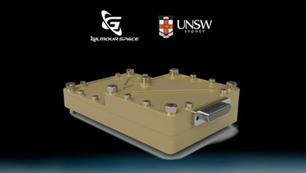
The Australian Space Agency has funded the development of an Australian aerospace-grade Global Navigation Satellite System (GNSS) receiver to use in rockets, satellites and aircraft under its Moon to Mars Supply Chain Capability Improvement Grants scheme.
Gilmour Space Technologies, in collaboration with the University of New South Wales (UNSW), will co-develop the GNSS receiver using an Australian supply chain and qualify it for use across a wide range of positioning, navigation and timing (PNT) applications. The GNSS receiver will be based on proven technology from UNSW, benefiting from Gilmour Space Technologies’ space manufacturing expertise and commercialization efforts.
Kody Cook, head of software, electrical, GNC and avionics at Gilmour Space Technologies, highlighted the importance of this initiative for the nation’s aerospace endeavors. “With the future becoming less certain, we’re thankful that Australia is investing in the sovereign development of exactly these types of fundamental capabilities,” he said. “If we could use more Australian-made avionics in our launch vehicles and spacecraft, we would.”
FrontierSI, a not-for-profit research organization specializing in positioning, geodesy, spatial infrastructures and rapid spatial analytics, has released a review of Australia’s resilient positioning, navigation and timing (PNT) policy to fortify the country’s PNT infrastructure. The review, expanded upon in a new white paper and technical report, was created in response to the increasing number of cyber threats.
“PNT is an essential utility we presently have no control over,” said Joshua Critchley-Marrows, FrontierSI’s space PNT lead. “Australia’s access to PNT is intrinsically linked to satellite-delivered services from foreign-owned and operated assets, such as the USA’s Global Positioning System (GPS). Investing in our infrastructure is crucial to ensure continuous access to this critical service that underpins nearly all aspects of our daily lives.”
According to FronteirSI, the reliance on foreign satellite systems exposes Australia to significant vulnerabilities, such as recent technological failures and cyber-attacks. These incidents emphasize the need for a self-reliant and robust PNT ecosystem capable of withstanding both unintentional and malicious disruptions.
FrontierSI aims to bolster PNT resilience by enhancing the systems’ robustness against disruptions and advocating for the development of assured, robust, augmented and alternative PNT solutions. The recommendations outlined in the white paper and technical report call for proactive measures, including legislative updates and supply chain risk assessments, to protect Australia’s critical infrastructure and economic vitality.
“Seen & Heard” is a monthly feature of GPS World magazine, traveling the world to capture interesting and unusual news stories involving the GNSS/PNT industry.
Photo: NOAA Ocean Exploration
Exploring the Largest Deep-Sea Coral Reef
Scientists have mapped the largest deep-sea coral reef, stretching hundreds of miles off the U.S. Atlantic Coast. While researchers have known since the 1960s that some corals were present off the Atlantic Coast, the reef’s size remained a mystery until new underwater mapping technology made it possible to construct 3D images of the ocean floor. The National Oceanic and Atmospheric Administration (NOAA) and a team of scientists recently published maps of the reef in the journal Geomatics. The reef extends for about 310 miles from Florida to South Carolina. The total area is nearly three times the size of Yellowstone National Park.
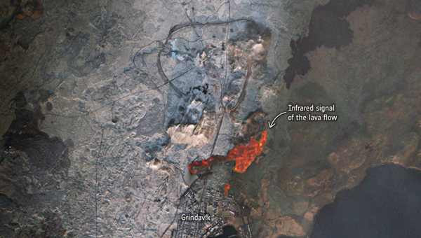
Photo: ESA
Lava in Iceland
Grindavík, a tiny town in Iceland, stands on the brink of volcanic lava flow in images captured by the European Space Agency (ESA). The lava originates beneath the Svartsengi volcano system — roughly 2.5 miles north of the town — which erupted on December 18 and January 14. ESA’s Sentinel2 satellite revealed the glow of the lava flow’s heat, not far from houses and other infrastructure within Grindavík. The town, with just 3,800 residents, has faced constant evacuations, as well as mini-earthquakes as a result, The Guardian reported.
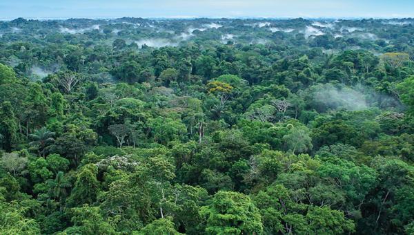
Photo: Maris Maskalans / iStock / Getty Images Plus / Getty Images
Lidar Reveals Lost Cities in the Amazon
In the Amazon rainforest, archeologists have discovered a vast and highly complex system of ancient cities dating back nearly 3,000 years. Located in Ecuador’s Upano Valley, the structures lie in the eastern foothills of the Andes mountains, according to a study published in the journal Science. After more than 20 years of research, the ancient urban centers were only discovered when the Ecuadorean government employed lidar technology. Researchers from France, Germany, Ecuador and Puerto Rico conducted a lidar survey that covered roughly 300 km2, which revealed a landscape full of organized human activities, including more than 6,000 rectangular earthen platforms, as well as agricultural terraces and drainage systems. According to the study, these structures formed at least 15 distinct settlements, which were connected by a system of wide, straight roads.
Australian scientists are attempting to track 1,000 cattle and buffalo using artificial intelligence (AI), and GPS satellites, reported euronews.next. An estimated 22,000 cattle and buffalo roam free in a remote area of Arnhem Land, Australia, though the exact number is unknown. Scientists are now collaborating with stockmen and indigenous rangers in a four-year program that involves monitoring feral animals from space. Titled SpaceCows, the remote herd management system is backed by the Australian government’s Smart Farming Partnership initiative. Local rangers and stockmen are chasing and catching animals to attach solar-powered tags with GPS receivers.
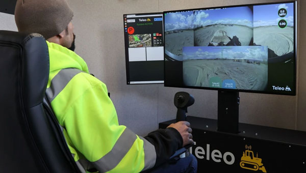
Position Partners has entered an agreement to partner with Teleo, a U.S. based company building autonomous technology for heavy equipment. Under the agreement, Position Partners will offer the full Teleo remote-operated and autonomous solutions across Australia, New Zealand and Southeast Asia.
Teleo’s system can be modified to any make and model of machine and includes the company’s proprietary software, a remote command center to operate the equipment, and a mesh network to enable two-way communication between the command center and machines.
The system incorporates sensors, including high dynamic range cameras that deliver high-definition visibility and video footage both day and night.
Once Teleo’s technology is integrated, users can control multiple machines, at multiple sites, from a single station.
“With ongoing labour and skills shortages in the construction sector, there is more work to be done than there are people to do it,” Position Partners CEO Martin Nix said.
Position Partners will offer the full Teleo solution to customers and support sales, installation and training in all countries in which the company operates including Australia, New Zealand, Singapore, Indonesia, Malaysia and the Philippines.
The natural sciences overlap — hence such fields as geophysics, astrobiology and biochemistry. So do the social sciences and humanities — hence such fields as political economy, political philosophy and social economics. Our very individual identities consist of multiple, intersecting factors — including gender, race, ethnicity, class, and sexuality.
Analogously, this magazine covers overlapping technologies. While we focus on global navigation satellite systems (GNSS) and other positioning, navigation and timing (PNT) technologies such as inertial systems, these technologies are often embedded in larger systems that also include sensors (such as lidar, radar and cameras) and, increasingly, artificial intelligence (AI).
That is why we so often cover unmanned aerial vehicles (UAV) — which use GNSS for positioning navigation, geofencing and stabilization; use sensors to collect data; and will soon use AI for mission planning and execution — and autonomous vehicles — which use GNSS and sensors for positioning and navigation and already use AI to make driving decisions in complex environments.
Of course, UAVs are also much in the news these days:
Since the start of the Russian invasion of Ukraine, both sides have been using several hundred UAVs every day. According to the Royal United Services Institute, a British think tank, the Ukrainians are losing some 10,000 UAVs a month on the battlefield. (By way of comparison, the French army currently has a little more than 3,000 UAVs in its arsenal.)
In the United States, the number of companies granted waivers by the Federal Aviation Administration to conduct beyond visual line of sight (BVLOS) operations keeps growing, enabling them to conduct much more efficient monitoring, inspections and mapping of infrastructure.
Following a recent increase in encounters between swimmers and sharks along beaches on Long Island, New York, in July UAVs began sweeping the ocean three times a day to detect danger. On July 14, the state’s governor, Kathy Hochul, announced the allocation of $1 million to purchase 60 new shark-monitoring UAVs.
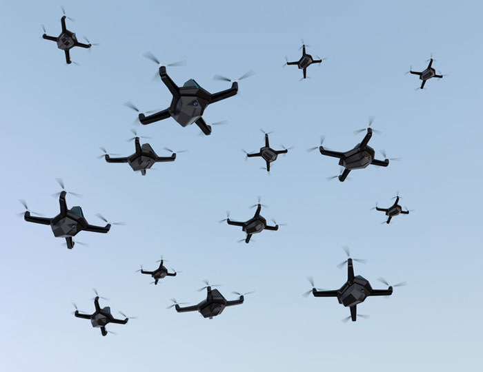
Also in July, 350 UAVs were lost during a practice light display show in Melbourne, Australia, ahead of a scheduled performance for the opening of the women’s World Cup. The UAVs appeared to stop mid-show and plummet into the Yarra River, most likely due to interference with GPS signals.
On August 30, researchers in Switzerland unveiled a small AI-powered quadcopter UAV that can outfly some of the best human competitors in the world. It whipped its way around an indoor racecourse in a matter of seconds and was able to beat its human rival in 15 out of 25 races, according to the journal Nature.
From mapping coastal areas with airborne lidar bathymetry to delivering medicines, from locating lost hikers to mapping fires, from enhancing the situational awareness of first responders to monitoring invasive plant species, UAVs are quickly becoming ubiquitous and essential.
Meanwhile, in San Francisco, where autonomous vehicles are already ubiquitous, but not everyone considers them essential, an anonymous group of protesters is surreptitiously placing orange traffic cones on some of them, confusing their sensors and rendering them inoperable.
The facility is designed to boost the manufacturing of the company’s world-first AI navigation systems for GPS-denied environments, including its digital fibre-optic gyroscope (DFOG) technology, Boreas.
Advanced Navigation is one of only four companies across the globe able to manufacture strategic-grade fiber-optic gyroscopes, which are designed to enable reliable navigation for marine vessels, space missions, aerospace, defense, autonomous vehicles and flying taxis.
The new facility will be home to extensive research collaborations between Advanced Navigation and the University of Technology Sydney. The collaborations aim to accelerate the production of new technologies, including its light detection, altimetry, and velocimetry (LiDAV) system, cloud ground control and indoor positioning technology designed to guide visually impaired passengers in underground train stations.
The new facility is aligned with the Australian government’s ongoing commitment towards building a STEM workforce and aims to boost employment in robotics, manufacturing, photonics, mechatronics, mechanical engineering and more.
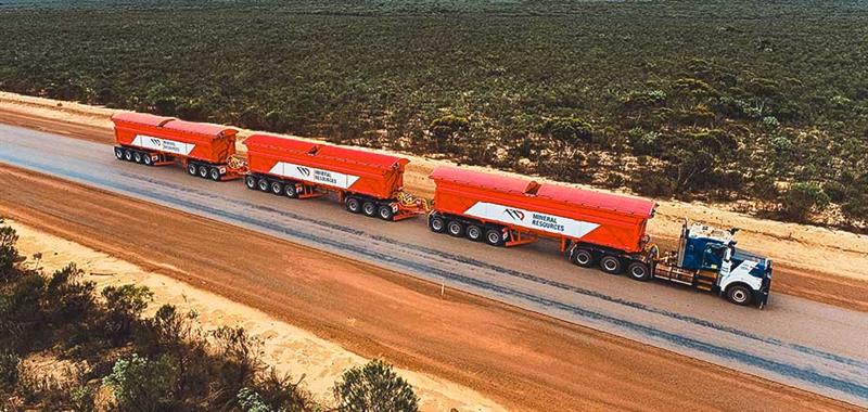
Hexagon has partnered with Mineral Resources (MinRes) to provide an autonomous haulage solution for a fleet of 120 fully autonomous road trains in Australia. The company says this will transform safety, productivity and sustainability in the region.
The fully autonomous road trains are a full-site, truck-agnostic solution. The addition of unmanned and autonomous systems will form an essential part of the supply chain for the MinRes Onslow Iron project in Western Australia’s Pilbara region.
The center of the autonomous platooning system is Hexagon’s autonomous solutions stack integrating drive-by-wire technology with an autonomous management system to orchestrate vehicle movement in road train haulage.
“Today’s agreement with MinRes will ensure that off-road transport activities will be safer, more sustainable, and more productive,” Paolo Guglielmini, president and CEO of Hexagon, said. “I’m excited to see how similar solutions can be applied in other off-road markets such as agriculture and heavy industry.”
More than 350 UAVs were lost during a practice light display show in Melbourne, Australia, on July 14, ahead of a scheduled performance for the opening of the women’s World Cup.
The UAVs appeared to stop mid-show and plummet into the Yarra River. Divers have since fished out hundreds of the UAVs.
According to the Resilient Navigation and Timing Foundation, the likely cause of the mass-crash was caused by interference with GPS signals. This incident shows that having multiple and robust navigation sources is important for safe UAV operation.
Q-CTRL, a quantum technologies company, has partnered with Australia’s Department of Defence to develop quantum sensors that will deliver quantum-assured navigation capability for military platforms.
The company’s partnership is a multi-year effort to field-deploy and validate miniaturized systems on defense platforms. It represents one of the first international partnerships between government and the private sector to apply quantum technology in real defense settings.
Quantum-enhanced navigation technology enables accurate vehicle positioning over long periods when GPS is unavailable. In air, space, underground and underwater, quantum navigation enables long-endurance missions that are otherwise impossible and is resilient against jamming or spoofing.
Q-CTRL announced its quantum sensing division in 2022. The company has worked with partners including Advanced Navigation and the Australian Army to demonstrate and deliver its technology for applications that include remote drone detection.
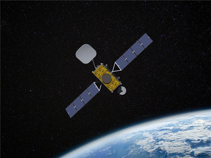
Inmarsat has partnered with Australia and New Zealand to deliver the Southern Positioning Augmentation Network (SouthPAN), which will provide accurate, reliable, and instant positioning services in the Asian Pacific region. The positioning service will be delivered on one of Inmarsat’s three new I-8 satellites in 2027.
SouthPAN will improve positioning accuracy to 10 cm for users in the maritime, agriculture and construction industries.
“SouthPAN represents extraordinary potential for the region,” Todd McDonell, president of Inmarsat Global Government, said. “It can save lives by enabling precision safety tracking, help farmers improve productivity through automated device tracking, or even support transport management systems of the future.”
The Inmarsat I-8 satellites will also be a critical part of a safety-of-life-certified SouthPAN for aviation and other applications, scheduled for 2028.
GPS plays a quiet, but integral role in Formula 1 (F1) racing. In a sport where split-second reactions are vital, GPS helps drivers and their teams to improve race to race and navigate tracks safely.
GPS is used to determine the speed of the car, which is beneficial for such things as straight line aerodynamic testing. It also provides data as to how fast F1 cars accelerate, enabling drivers and their teams to predict how much power their competitors are producing on the track.
The streaming of location data can be converted to telemetry, such as what track maps viewers see on F1 broadcasts, that can determine which driver in a head-to-head scenario was faster on each sector of the track. This data is then used to work out strengths and weaknesses of cars relative to each other.
In addition, GPS plays a large role in creating a safe racing space.
If a driver is slowing down to recharge a battery, make space for a hot lap, or cool down tires between runs, and another car is entering the track at full racing speed, this creates safety concerns. GPS receivers on the cars and radio links to transmit their positions are used to show where cars are on the track at any moment. Teams use this information to manage traffic during sessions such as qualifying races to improve overall track safety.
The impact of losing live location data was seen at the 2023 Australian Grand Prix FP1 in late March. At the opening practice session, a red flag was flown due to loss of location data triggered by a glitch in the distribution of live tire information. This caused several near-misses on the track because drivers no longer received traffic advisory calls from their team, reported AutoSport.
For more on using GPS in F1, check out the video below by WTF1.
A couple of stories about unmanned air vehicles in the war in Ukraine and a response to the recent Open Letter by the “Future of Life Institute” with more than 200,000 signatures on advanced AI, which urged a six-month moratorium to allow the development of seemingly much needed AI regulations.
The war in Ukraine
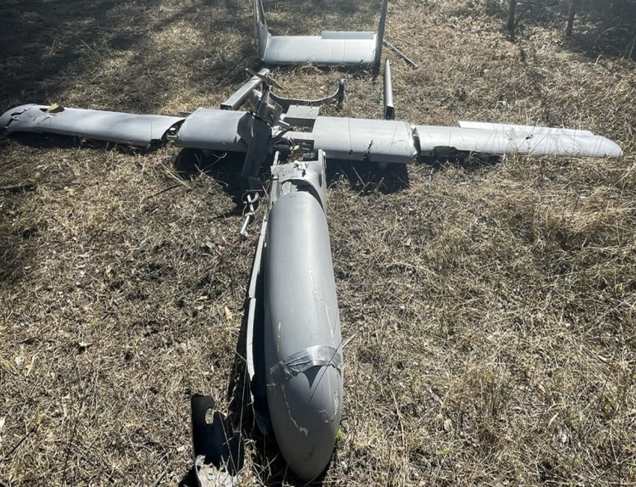
It has been reported that Ukrainian forces were operating the commercially available Chinese Mugin 5 UAV, presumably for surveillance of Russian forces inside Russian-occupied territory. The Mugin 5 can be bought commercially for $10-15,000 and is manufactured by Mugin, which is based in the port city of Xiamen, on China’s eastern coast. In a previous statement posted on the company’s website on March 2, Mugin Limited said that it “condemns” the use of its products during warfare and that it ceased selling products to Russia or Ukraine at the start of the war. However, Russian forces claimed in January 2023 that it had actually shot down one of these Chinese-made UAVs being flown by Ukrainian forces over their territory.
Then, just this week, Ukrainian forces apparently were able to track a low level, slow-moving air vehicle coming at them from Russian occupied territory. After some time, they were able to intercept the UAV, which carried a flashing navigation light, from the ground, and were able to bring it down using small arms. The remains of the crashed UAV were found in a clearing in the forest; a single 44 lb bomb was removed from the wreckage and safely exploded by the Ukrainian team.
Weaponized Mugin 5 following crash in Ukraine forest. (Image: Screenshot from video from Kanal13 Youtube)
Somewhat worse for wear, the Mugin 5 UAV appears to have been held together in places by duct tape and other patches. Is it possible that having shot down a Ukrainian surveillance UAV the Russians recovered these remains and crudely restored the unit to flying and navigating capability, then sent it back to Ukraine owners carrying a bomb? Anything is possible in this conflict.
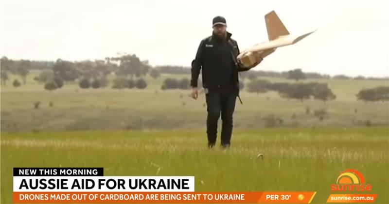
Staying with this conflict and the use of UAVs by both sides, its seems that Australia has come up with a low-cost surveillance UAV that is virtually undetectable and it’s proving quite popular with the Ukrainians. Most defensive detection involves some form of radar scanning, which relies on radar returns bouncing off a flying target. The Australian company SYPAC in Melbourne has developed the Corvo Precision Payload Delivery System (PPDS). It is a wax-coated cardboard UAV, held together with elastic bands and glue, but carrying sophisticated guidance and control electronics.
(Image: Screenshot of video posted by 7 News Australia)
SYPAQ has developed the CORVO UAV under an AU $1.1 m government contract with the objective of creating a low-cost, disposable UAV to deliver urgent needs — such as medical supplies or to resupply small arms ammunition to the Australian military. CORVO is autonomous once launched, using GNSS guidance, or dead reckoning if GNSS signal is lost or jammed. Apparently, hundreds of these disposable UAVs have already been shipped to Ukraine.
While a surveillance role was originally envisaged in Ukraine, it is reported that, “They have been very good at inflicting lots of damage on the enemy,” according to Ukraine’s ambassador to Australia. So, CORVO UAVs may well have already been weaponized.
Open Letter on AI development
Following a recent open letter supported by Elon Musk and Steve Wozniak that proposes a six-month halt on advanced AI development, I was recently approached on behalf of Professor Ioannis Pitas, director of the Artificial Intelligence and Information Analysis (AIIA) lab at the Aristotle University of Thessaloniki (AUTH) and management board chair of the AI Doctoral Academy (AIDA) with somewhat different views.
In order to further the on-going discussion, I thought it would be appropriate to give some space to an alternate view on AI development. So here are some paraphrased comments approved by Pitas:
Could AI research be stopped even for a short time? It is doubtful. Further AI progress is necessary for us to transition from an information society to a knowledge society.
Maybe we have reached the limits of AI research carried out primarily by Big Tech, which appears to treat powerful AI systems as black boxes whose functionality may be poorly understood.
It seems that the open letter reflects welcome and genuine concerns on social and financial risk management. Are expensive lawsuits in an unregulated and unlegislated environment inevitable as a consequence of ill-advised AI pronouncements?
However, it is doubtful whether the proposal for a six-month ban on large-scale experiments is the solution. It’s impractical for competitive commercial and geopolitical reasons, with very few benefits.
Of course, AI research can and should become more open, democratic and scientific.
Here are a number of suggested options:
Should elected parliaments and governments make the important decisions on AI rather than corporations or individual scientists?
Every effort should be made to facilitate the positive aspects of AI social and financial progress and to minimize any negative aspects.
The positive impact of AI systems can greatly outweigh their negative aspects if proper regulatory measures are taken.
It is possible that the biggest threat is that AI systems could deceive too many people who have little related knowledge. This can be extremely dangerous.
We should counter the big threat coming from the use of AI in illegal activities — cheating on university exams is a rather benign use — while the possibility of criminal exploitation may be very much worse.
The impact of AI on labor and markets will be very positive in the medium to long term.
AI systems should be required by international law to be a) registered in an ‘AI global register’, and b) users should be notified when they converse with or use the results of an AI system.
As AI systems have a huge impact on society, and in order to maximize their benefit and socio-economic progress, it is recommended that: o advanced key AI system technologies should become mostly open o AI-related data should be at least partially open.
However, strong financial compensation schemes should be established now for AI technology developers to compensate them for any component that becomes open source.
Well, this is a bit of a departure from our nominal UAV/AI report, but there does seem to be a growing number of voices calling for some form of AI regulation and more extensive discussion might well help this movement come to a conclusion. And it would seem that the U.S. administration is listening, as the U.S. Commerce Department has announced that it is seeking inputs from interested parties for methods to test the safety of AI systems — to ensure that they are “legal, effective, ethical, safe and otherwise trustworthy.” In order to enforce these standards, the department is investigating whether audits and inspections to certify AI systems should be required before their release on the unsuspecting public.
The U.S. Commerce Department is apparently not alone in these concerns, as China is also looking to ensure that systems such as Alibaba Cloud’s Tongyi Qianwen, a competitor to OpenAI’s ChatGPT, are socially beneficial. Meanwhile, following the release of ChatGPT and similar products from Microsoft and Google, awareness has grown of the capabilities of the latest AI tools that generate human-like text passages, and even new images and video. The UK Department for Science, Innovation and Technology and the Office for Artificial Intelligence on the other hand, seem to be looking for an approach to regulation that will not restrict AI innovation.