Intel CEO Brian Krzanich demonstrated the broad capabilities UAV technology during his keynote presentation at the 2016 Consumer Electronics Show Jan. 5, in Las Vegas. Krzanich showcased the Yuneec Typhoon H with Intel RealSense Technology. (Photo: Intel)
Intel has signed a definitive agreement to acquire Ascending Technologies, a drone company located in Krailing, Germany, that produces drone auto-pilot software and algorithms.
Intel has already partnered to combine Ascending Technologies’ sense-and-avoid algorithms with Intel RealSense technology’s real-time depth-sensing capability. These technologies can improve drone safety, helping them avoid obstacles and collisions.
With Ascending Technologies, Intel gains expertise and technology to accelerate the deployment of Intel RealSense technology into the fast-growing drone market segment. The Ascending Technologies team is expected to continue supporting its current customers while also collaborating with Intel’s Perceptual Computing team to develop unmanned aerial vehicle (UAV) technology that can help drones fly with more awareness of their environments.
“Drones are quickly emerging as an important computing platform of the future, writes Josh Walden on an Intel blog. “With practical applications ranging from disaster response, to infrastructure inspection, to delivery of goods, UAVs offer an incredible opportunity for innovation across a multitude of industries. As a result, Intel is positioning itself at the forefront of this opportunity to increasingly integrate the computing, communications, sensor and cloud technology required to make drones smarter and more connected.”
The founders of Chronos and UrsaNav have formed a new collaboration, named Taviga, that will focus on preserving and establishing low-frequency (LF) positioning, navigation and timing (PNT) networks in the United Kingdom, Europe and the U.S., using repurposed Loran-C or purpose-built eLoran technology.
Taviga aims to ensure timing and navigation for critical infrastructure, protecting it from cyber and other threats, and addressing the concern that over-dependence on single systems for PNT increases vulnerability.
According to a joint press release, “Taviga combines the founders’ decades of experience specializing in low-frequency (LF) PNT technology and industrial timing applications at national and international levels. Its objective is to provide a commercially operated assured LF PNT service.”
Partner with Government. Charles Curry of Chronos Technology Ltd. in the UK and Charles Schue of UrsaNav Inc. in the U.S. joined forces to launch Taviga Ltd. and Taviga LLC. Taviga anticipates working in partnership with government agencies and other entities that have a vested interest in reducing the vulnerability and improving the resilience of critical national infrastructure with a dependency on the GPS and other GNSS sources of PNT.
“We have been researching the precise timing capability of eLoran transmissions for over 10 years,” Curry said. “During that time, the system has never failed, and most impressively it has continued to deliver sub-microsecond time accuracy traceable to UTC in very challenging locations, including deep inside buildings.
“Our research program was supported by the UK’s Innovation Agency — Innovate UK through two flagship projects, GAARDIAN and SENTINEL,” Curry continued. “These two projects highlighted the vulnerabilities that threaten GPS signals (and in the future, Galileo) such as jamming, interference and spoofing. They also demonstrated how eLoran is a technically dissimilar source of PNT and not vulnerable to the same types of interference. eLoran is a truly complementary source of PNT, ideal for use in critical infrastructure applications such as telecoms, broadcasting, financial services and power utilities.
“Every government, academic and industrial study has resulted in the selection of the LF technology known as Enhanced Loran, or eLoran, as the best wide-area complement to GNSS,” UrsaNav’s Schue added. “There is no doubt that the combination of GNSS and eLoran provides the PNT resilience that most users require.
“Integrated GNSS-eLoran solutions can provide the proof-of-time and proof-of-position necessary to safeguard national infrastructure and for business continuity of operations,” Schue said. “Adding eLoran to the PNT mix enables or enhances capabilities of regional and purpose-built solutions. Overreliance on a single solution is neither prudent nor safe.”
Tests led by Chronos and using UrsaNav’s eLoran receiver engine have consistently demonstrated positioning accuracies of better than 10 m and timing accuracies of less than 100 nanoseconds in the area of differential eLoran reference sites.
Taviga’s goal is the long-term operation of an eLoran system for at least 10 years, a period that provides the necessary service assurance continuity to enable industrial users to invest with confidence in an eLoran-based timing and navigation service that complements their GNSS solutions. As users become accustomed to the capabilities and resilience of a combined GNSS-eLoran solution, Taviga expects to expand the service footprint worldwide.
Timing
Leap second lives on
The International Telecommunication Union (ITU) World Radiocommunication Conference (WRC-15) decided that further studies are required on the impact and application of a future reference time-scale, including the modification of Coordinated Universal Time (UTC) and suppressing the so-called “leap second.”
Leap seconds are added periodically to adjust to irregularities in the Earth’s rotation in relation to UTC, the current reference for measuring time, in order to remain close to mean solar time (UT1). A leap second was added most recently on June 30 at 23:59:60 UTC. The proposal to suppress the leap second would have made continuous reference timescale available for all modern electronic navigation and computerized systems to operate while eliminating the need for specialized ad hoc time systems.
A report will be considered by the World Radiocommunication Conference in 2023. Until then, UTC shall continue to be applied as described in Recommendation ITU‑R TF.460‑6.
Disconnect from the Sun? As a representative of the Lick Observatory of the University of California stated, “a problem is that simply omitting leap seconds would redefine the meaning of the word “day” so that it is not related to the sun in the sky, nor connected with the rotation of the Earth.”
“Modern society is increasingly dependent on accurate timekeeping,” said ITU Secretary-General Houlin Zhao.“ITU is responsible for disseminating time signals by both wired communications and by different radiocommunication services, both space and terrestrial, which are critical for all areas of human activity.”
Further studies will be coordinated by ITU along with several other international organizations.
Inertial/GNSS
Drone rules, registry
The Federal Aviation Administration announced in December an official rule and registration process for hobbyists who own small unmanned aircraft weighing more than 0.55 pounds and less than 55 pounds, including payloads such as on-board cameras.
The online registration system does not yet support registration of small UAS used for any purpose other than hobby or recreation — for example, using an unmanned aircraft in connection with a business. The FAA is developing enhancements that will allow such online registrations by spring of 2016.
The registration procedure is a statutory requirement that applies to all hobby aircraft. Under this rule, any owner of a small UAS who has previously operated an unmanned aircraft exclusively as a model aircraft prior to Dec. 21, 2015, must register no later than Feb. 19, 2016. Owners of any other UAS purchased for use as a model aircraft after Dec. 21, 2015, must register before the first flight outdoors.
Owners may register through a web-based system or paper-based process. There is a $5 registration fee, but the FAA is offering a full rebate for those who register before Jan. 20, 2016.
Under the rule, each aircraft must be marked with a unique number, although not necessarily the serial number. The goal is to help authorities track down an owner if a drone collides with another aircraft, flies too high or encroaches on an airport.
Owners using the model aircraft for hobby or recreation will only have to register once and may use the same identification number for all of their model UAS. The registration is valid for three years.
“We expect hundreds of thousands of model unmanned aircraft will be purchased this holiday season,” FAA Administrator Michael Huerta said. “Registration gives us the opportunity to educate these new airspace users before they fly so they know the airspace rules and understand they are accountable to the public for flying responsibly.”
Launching at a tower site near Vaughn, New Mexico, Insitu accomplished a commercial beyond-visual-line-of-sight operation with an unmanned aerial system (UAS).
The Oct. 25 event marked the beginning of a week-long series of flights with BNSF Railway designed to show how UAVs can enhance the safety of critical infrastructure by aiding with inspections.
During the 14 hours of flyovers, the Insitu ScanEagle targeted problems such as washouts and bridge damage. The information gathered was then fed back to Insitu personnel on the ground in real time.
Insitu and BNSF officials launch ScanEagle for the historic first flight. (Photo: Insitu Inc.)
The flights were part of the U.S. Federal Aviation Administration’s (FAA’s) Pathfinder program announced on May 6. For Pathfinder, the FAA selected three companies — CNN, PrecisionHawk and BNSF — to explore commercial use of drones beyond operations proposed in its draft UAS rule published in February.
The FAA tasked BNSF Railway, the second-largest freight railroad network in North America, with inspecting rail infrastructure beyond visual line of sight. BNSF operates 32,500 miles of track.
BNSF selected the Scan-Eagle because it carries an FAA certification for commercial applications. The UAV is capable of providing 3D rendering as well as high-resolution video magnification.
In its first day of operations, the ScanEagle UAV provided real-time video covering 64 miles of the 132-mile stretch of track that BNSF has designated for the exercise. The ScanEagle is capable of flying for up to 24 hours at speeds of up to 80 knots.
The exercise demonstrated how, in addition to a railway company’s traditional methods of track monitoring, unmanned aircraft can not only improve inspections, but keep employees out of harm’s way and harsh conditions.
Insitu, a subsidiary of The Boeing Company, creates and supports unmanned systems and software technology for collecting, processing and understanding sensor data.
Under Pathfinder, CNN is researching visual line of sight operations for newsgathering in urban areas, and working with Georgia Tech University to improve newsgathering for all organizations. PrecisionHawk is investigating agricultural operations for rural areas, flying outside line of sight.
An illustration of Tern, Northrop Grumman’s next-generation unmanned system for maritime ISR and strike. (Image: Northrop Grumman)
The Defense Advanced Research Projects Agency (DARPA) and the Office of Naval Research have awarded Northrop Grumman the third phase of the Tern unmanned systems program. Phase three plans include final design, fabrication and a full-scale, at-sea demonstration of the system.
Tern seeks to develop an autonomous, unmanned, long-range, global, persistent intelligence, surveillance, reconnaissance (ISR) and strike system intended to safely and dependably deploy and recover from small-deck naval vessels with minimal ship modifications.
Designed to operate in harsh maritime environments, Tern aims to enable greater mission capability and flexibility for surface combat vessels without the need for establishing fixed land bases or requiring scarce aircraft carrier resources.
According to DARPA, Tern would use smaller ships as mobile launch and recovery sites for medium-altitude long-endurance (MALE) unmanned aircraft (UAVs). Named after the family of seabirds known for flight endurance — many species migrate thousands of miles each year — Tern aims to make it much easier, quicker and less expensive for the Department of Defense to deploy persistent airborne intelligence, surveillance and reconnaissance (ISR) and strike capabilities almost anywhere in the world.
Ideally, Tern would enable on-demand, ship-based unmanned aircraft systems (UAS) operations without extensive, time-consuming and irreversible ship modifications. It would provide small ships with a “mission truck” that could transport ISR and strike payloads to very long distances from the host vessel. The solution would support field-interchangeable mission packages for both overland and maritime missions. It would operate from multiple ship types and in elevated sea states.
Northrop Grumman’s Tern solution seeks to provide an innovative system that integrates mature and advanced technologies, including a distinctive propulsion solution designed to help expand global persistent ISR/strike capabilities for small-deck naval surface vessels.
“We intend to highly leverage our Unmanned Systems Center of Excellence to develop and demonstrate this type of demanding unmanned systems capability to advance the Navy’s mission,” said Chris Hernandez, vice president, research, technology and advanced design, Northrop Grumman Aerospace Systems. “We believe our unique ship-based unmanned systems experience, expertise, and lessons learned from programs including our MQ-8B/C Fire Scout, MQ-4C Triton, X-47A Pegasus and X-47B UCAS, is critical to the success of the Tern.”
“Using an innovative design that integrates vertical take-off and landing transitioning to an efficient flying-wing for cruise, our team is creating a system that we believe would achieve Tern’s revolutionary performance objectives in support of our combatant commanders,” said Ralph Starace, director, advanced design, Northrop Grumman Aerospace Systems. “Our full-scale demonstrator system is highly traceable to our operational concept to burn down risk, resulting in a compelling step forward for this game-changing, multi-mission capability,” said Bob August, Tern program manager, Northrop Grumman Aerospace Systems.
The Northrop Grumman Tern team includes its wholly owned subsidiary Scaled Composites, as well as General Electric (GE) Aviation, AVX Aircraft Company and Moog.
The Spanish navy is using UAVs for intelligence operations on the northern and eastern coasts of Somalia to locate possible illegal activities. This past summer, the navy used the Scan Eagle unmanned air system during Operation Atalanta, a European Union mission combating piracy in the Indian Ocean.
The Scan Eagle system, deployed from the amphibious assault ship Galicia, produced valuable intelligence for the Naval Force of the European Union (EUNAVFOR). The system consists of four aircraft, one of which is designed to acquire night images.
The New Spanish Armada: Sailors onboard Galicia in the Indian Ocean prepare to launch a Scan Eagle on a surveillance mission. (Photos: Spanish Ministry of Defense)
The Scan Eagle is launched via a catapult, and lands by means of a pole, into which the aircraft is “locked.” A set of antennas sends and receives information between the control station and the UAV.
The system can operate continuously for more than 18 hours at a stretch, collecting data, images and video both day and night.
During Operation Atalanta, the Scan Eagles completed more than 175 flight hours, collecting imagery for more than 11 hours without being detected and providing command with real-time images of possible targets.
The UAV system was also deployed in Afghanistan, where it operated from the advanced support base of Qala i Naw until the withdrawal of the Spanish contingent in 2013.
The mission represents a milestone for the Spanish navy — the first remotely piloted aircraft operating successfully from a navy vessel.
Night eyes: One of the four UAVs deployed was equipped for night imagery. (Photo: Spanish Ministry of Defense)Control Station: From the ship’s hangar, the UAV is controlled by operators of the new 11th aircraft squadron of the Spanish Navy. (Photo: Spanish Ministry of Defense)
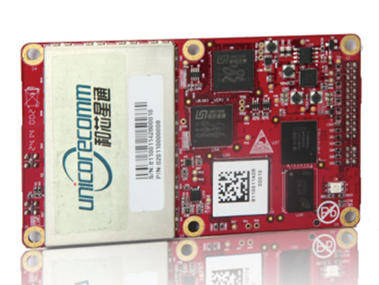
The UB380 GPS/GLN/BDS tri-constellation octa-frequency high-precision board.
High-end GNSS board
For high-precision positioning, navigation and GBAS applications
The UB380 multi-GNSS receiver has 384 channels, based on Unicore’s multi-GNSS system on a chip. It features Unicore’s latest real-time kinematic (RTK) engine, which can process triple-frequency BDS and GPS and dual-frequency GLONASS observation data. This can significantly reduce initialization time, improve position accuracy and enhance reliability in difficult environments such as city canyon and canopy, as well as make the long baseline RTK possible. The receiver board can support GPS L1, L2 and L5; GLONASS L1, L2; and BDS B1, B2 and B3. The support of GPS L2P and L2C can satisfy the high-precision requirements of GBAS reference station equipment. The UB380 is compatible with industry-standard GNSS boards in size, interfaces and electrical standards.
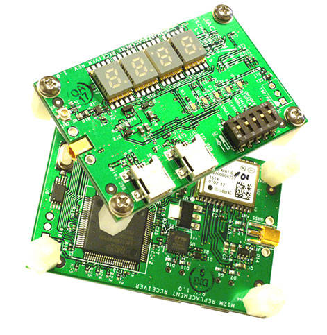
M12M Replacement Receiver GNSS module. Photo: Jackson Labs Technologies
Legacy receiver module
Plug-and-play upgrade for xli server, fury GPSDO
The M12M Replacement Receiver released is form, fit and function compatible to the legacy Motorola M12M and M12+ timing and navigation receivers. It uses an eighth-generation GNSS timing-enabled receiver, allowing 72 GNSS-channel reception with any two GNSS systems being received simultaneously. It adds configurability via USB ports and dual in-line package (DIP) switches and various status displays. GPS, GLONASS, BeiDou, QZSS and SBAS signals can be received. The module supports NMEA, Motorola binary and u-blox binary as well as SCPI (GPIB) communication protocols; is designed to allow plug-and-play retrofit of equipment designed for legacy Motorola receivers; and is certified as a plug-and-play upgrade to the Symmetricom/Microsemi XLI server and the Jackson Labs Technologies Fury GPSDO. It can be used to retrofit products for GLONASS/BeiDou compatibility. The module enhances performance parameters such as time to first fix; position, velocity and timing accuracy; tracking sensitivity; the addition of SBAS (differential compensation) capability; and the addition of external interfaces such as USB and a synthesized frequency output.
High-gain, high-rejection family designed for cell and telecom
The TW3150/52 antennas feature a 50-dB low-noise amplifier (LNA) gain to handle long cable runs often associated with installation on telecommunications towers. They cover the GPS L1 and SBAS (WAAS, EGNOS and MSAS) frequency bands and provide excellent cross-polarization rejection and enhanced multipath rejection.The TW3150 antenna features a four-stage dual-filtered LNA, while the TW3152 antenna includes an additional SAW pre-filter. This provides better than 80-dB of signal rejection above 1610 MHz and below 1545 MHz. The antennas are IP67 and MIL-STD-801F Section 509.4 compliant to withstand challenging environmental conditions.
Provides support for GPS, GLONASS and BeiDou with MediaTek
The ORG1510-MK Multi Micro Hornet is a fully integrated multi-GNSS (GPS, GLONASS and BeiDou) module. The miniature low-power architecture is designed to provide a GNSS component to devices that require fully featured components with small footprints, such as UAVs designed to follow action sports and other fast-moving activities or wearables. The ORG1510-MK contains the MediaTek MT3333 chip, which supports a fast update position calculation rate, and contains an onboard flash memory that does not erase when power is off. It consumes little power with the use of both standby mode and backup mode, and, in advanced applications, a periodic mode that can turn the device on and off when in backup or standby.
Designed for recording sports activities, the FLYPRO XEagle UAV has replaced traditional UAV remote controllers with the XWatch, a smartwatch designed to control the XEagle. Users can control the devices to take off, land and follow, as well as adjust flight height with one click on the wrist within 300 meters. The smartwatch design enables users to fly the aerial vehicles to take high-definition pictures and videos while engaging in intense sports. A voice-control feature allows users to fly the XEagle without moving their hands using commands such as “FLYPRO, take off” and “FLYPRO, follow me”.
Thermal imaging camera core designed for integration
FLIR Tau 2 thermal imaging cameras are suited for demanding applications like UAVs, thermal weapon sights and handheld imagers. Improved electronics now give Tau 2 even more capabilities, including radiometry, increased sensitivity (<30 mK), 640/60 Hz frame rates, and powerful image processing modes that dramatically improve detail and contrast. Since the electrical functions are common between the Tau 2 640, 336 and 324, integrators have direct compatibility between the different camera formats, and Tau camera versions share many of the same lens options.
Amazon’s latest version is designed to deliver packages in 30 minutes
Source: Amazon
A new drone design introduced by Amazon for its planned Prime Air Delivery service is larger than the previous quadcopter and has a more advanced design, including the ability to operate with an auto-loading system that sets the payload inside an internal carrier bay. The hybrid design combines vertical lift and horizontal flight capabilities using lift fans and a pusher prop. The drone is capable of flying at an altitude of about 400 feet (122 meters) at about 55 mph (88 km/h) for a range of 15 miles (24 kilometers). It has sense-and-avoid situational awareness technology and is designed to deliver small packages in under 30 minutes.
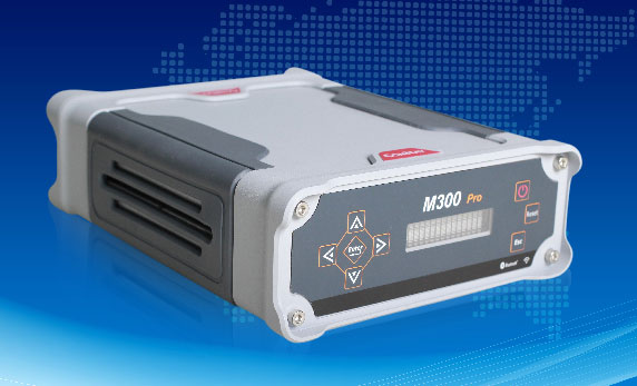
The M300 Pro is a multi-purpose CORS GNSS receiver designed for applications such as positioning infrastructure, active geodetic network, deformation monitoring, machine guidance, harbor construction, land surveying and marine surveying. Designed for reference stations, the M300 Pro tracks GPS, GLONASS and BeiDou (B1, B2, B3), and will track Galileo, QZSS and other coming constellations. Its web server function enables remote control for access, configuration, programming, data download, reboot/restart, firmware update and code registration. It is compatible with many kinds of CORS software, using the standard data format RTCM and the various data transfer protocols such as UDP, TCP and NTRIP. Raw GNSS observation data can be saved in RINEX format and remotely downloaded. Multiple ports can be configured and connected with external sensors such as meteorological sensors, barographs and inclinometers. The PPS output function provides a guarantee for precision timing. It also has the functionality of event mark and external memory.
The Leica Velocity and Displacement Autonomous Solution Engine (VADASE) detects fast movements of man-made and natural structures in real time, running on board Leica reference stations and monitoring receivers. VADASE provides an in-depth look at accurate, high-rate velocity and displacement information of various activities and structures. It gives engineers and researchers complete, precise and reliable monitoring information. VADASE delivers actionable information independent of any GNSS real-time kinematic (RTK) correction service.
GNSS receiver with onboard memory for data storage
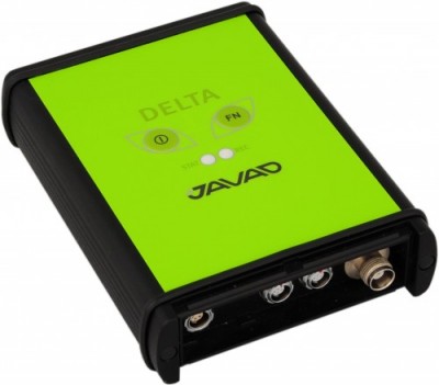
The DELTA-3 receiver has 864 GNSS channels, along with three powerful processors and program memory in a single chip, which uses less power and makes the total system less expensive. The 864 channels allow tracking of all current and future satellite signals. Delta-3 can track and decode the QZSS LEX signal messages. It is a powerful and reliable receiver for high-precision navigation systems, including high-dynamic systems, for machine and traffic control, high-precision surveying, and geodynamics and aerogeophysics applications. Delta-3 can operate as a receiver for post-processing, as a Continuously Operating Reference Station (CORS), or as a portable base station for real-time kinematic (RTK) applications, and as a scientific station collecting information for special studies such as ionosphere monitoring.
A configuration of ArcGIS and a JavaScript application
Photo Survey is designed for local governments to publish street-level photo collections and conduct focused property surveys that can identify blight, damaged structures or construction activity. It leverages location-enabled photos produced by many commercially available cameras and simplifies data processing so street-level photo collections can be gathered on a regular basis. Photo collections can then be combined with relevant survey questions in an ArcGIS Online map, and shared with the Photo Survey application. Once complete, the Photo Survey application can be used by the general public or local government staff to review street-level photos and complete property surveys.
Qualcomm Technologies, Tencent and Zerotech announced and demonstrated at CES 2016 a commercial drone based on the Qualcomm Snapdragon Flight platform. The Consumer Electronics Show is being held this week in Las Vegas.
Tencent, China’s largest Internet service portal, and drone maker Zerotech have co-designed Ying, a small, lightweight drone that can be easily controlled right from a smartphone, leveraging the companies’ advanced software, and the computational power of the Qualcomm Snapdragon 801 processor, making it easy to capture video that can be streamed directly to your friends using QQ and Wexin.
The Ying drone uses the Snapdragon 4K capture to “supersample” the video image, providing a stabilized, corrected video and picture recording at 1080P as well as first person view at 720p that can be directly streamed or uploaded to Tencent’s drone social community platforms Weixin and QQ. Weixin (“we chat”) is a mobile text and voice messaging communication service developed by Tencent in China, first released in January 2011.
“We continue to bring a range of new research and development products to meet the needs and demands of our customers across various industries,” said Jianjun Yang, founder of Zerotech. “We’re excited to work with two companies who are technology leaders in their space — Qualcomm Technologies who has brought their mobile expertise to the consumer drone industry, and Tencent with its popular social networks, to bring a lightweight, highly integrated consumer drone that enables users to share their photos and videos instantly with their friends.”
“The consumer drone market is expected to soar in the next few years, and Ying is a good example that shows how Tencent is working closely with the fast growing drone market by enriching use cases of our core and leading social communication services,” said Roland Cai, vice president, IEG, Tencent. “Zerotech’s expertise in UAV manufacturing and, Qualcomm Technologies’ highly integrated drone development board coupled with our social networking platforms allows us to provide our hundreds of millions of active users with a competitive price on a high quality drone such as Ying that can share their experiences in real time.”
Snapdragon Flight is a highly optimized 58 x 40 millimeter board targeted specifically for consumer drones and robotics applications. Snapdragon Flight is based on the Snapdragon 801 processor, with GPS, 4K video capture and robust connectivity, along with advanced drone software and development tools, bringing cutting-edge mobile technologies to create a new class of consumer drones.
“Consumer drones are becoming the ultimate selfie camera but with advanced capabilities such as 4K capture and high performance computing and connectivity,” said Raj Talluri, senior vice president, Qualcomm Technologies. “We are tapping into our proven mobile technologies for the exciting drone opportunity and teaming up with Zerotech and Tencent enables us to support smaller, smarter drones that deliver real-time content to China’s largest social media network.”
CES attendees can check out the Ying and other drones and robotics at the Qualcomm Technologies Booth #25824 in South Hall. Attendees can also attend the official launch event for the Ying at Zerotech’s Booth #26035 in South Hall on Jan. 7 at 11 a.m. PT.
The Federal Aviation Administration’s (FAA) drone app — B4UFLY — is being released for Apple, following an initial beta testing period. The app can be dowloaded from the Apple store.
The FAA also is releasing a beta version of B4UFLY for Android devices, which can be downloaded from Google.
B4UFLY tells users about current or upcoming requirements and restrictions in areas of the National Airspace System (NAS) where they may want to operate their unmanned aircraft system (UAS).
“We expect B4UFLY will help raise public awareness about what it means to operate unmanned aircraft safely,” FAA Administrator Michael Huerta said at the Consumer Electronics Show in Las Vegas. “It is another important part of our education and awareness efforts to foster a culture of safety and accountability for the UAS community.”
The B4UFLY app includes a number of enhancements the FAA developed as a result of user feedback during the beta testing announced in May 2015. Within two taps, users know if it is safe to fly at their current location. The app provides a status indicator that tells users: “Proceed with Caution,” “Warning – Action Required,” or “Flight Prohibited.”
The app also features a planner mode that allows users to select a different time and location for an upcoming flight and determine if there are any restrictions at that place and time.
By law, hobbyists who want to fly within five miles of an airport must notify the airport operator and the air traffic control facility (if there is one) prior to flying.
For now, B4UFLY will ask users who are supposed to notify the airport before flying for voluntary information about their planned flight. This will not meet the statutory requirement to notify the airport and air traffic control facility, but the data will help the agency make informed policy decisions related to notification. This information will not be publicly available.
You can find more information on our B4UFLY webpage.
Drone maker DJI is introducing enhancements to its Phantom 3 and Inspire 1 quadcopters at CES 2016, a consumer electronics and technology trade show held Jan. 6–9 in Las Vegas.
\The Phantom 3 4K’s introduction is the result of strong consumer demand for top resolution cameras and ultrasonic sensors, the company said, which enable flight indoors and in areas with a weak GPS signal. The Phantom 3 4K comes with an integrated, gimbal-stabilized 4K camera and has remote-control buttons for playback, video recording and camera shutter.
Instead of DJI’s Lightbridge video-transmission system, the Phantom 3 4K uses built-in WiFi to transmit the video downlink and on-screen data. The drone’s WiFi video downlink is effective up to a distance of 1.2 kilometers.
“The Phantom 3 4K fills an important gap in our Phantom portfolio. It offers a high-quality camera and smart navigation system for a lower price than our professional models. This is possible, as we have replaced the DJI Lightbridge system with a built-in WiFi link,” said Paul Pan, DJI’s senior product manager.
The Phantom 3 4K will stay aloft for 25 minutes on a full battery charge. DJI also has made stylistic change to its Inspire 1 Pro. The Inspire 1 Pro Black Edition comes with a black controller, battery and a shell with a matte finish. It comes equipped with DJI’s best-in-class Micro Four Thirds camera, the Zenmuse X5.
In celebration of DJI’s 10th anniversary, the promotional price of the DJI Phantom 3 4K edition is $799, starting Jan. 6. This promotion also extends to the Phantom 3 Advanced model, now priced at $799, and the Phantom 3 Standard, at $499. DJI says the price may be subject to change.
The original Inspire 1 Pro, with a white shell, battery case and controller, will continue to be sold alongside the new model.
“One of the most-frequent questions we get from professional drone operators is ‘when will DJI come out with a black Inspire?’ The answer is now,’” said Ferdinand Wolf, manager of DJI Studios Europe.
DJI’s main booth at CES 2016 will be in South Hall 2, No. 25602, and Central Hall, No. 9845. The exhibits will feature a flying cage for attendees to attempt flying a drone with First Person View, an Osmo Zone for testing the filmmaking tool, a showcase of solutions created with the DJI SDK and a display of work created by the SkyPixel community.
Drone-maker DJI has launched a public beta version of its new geofencing system in North America and Europe.
Geospatial Environment Online (GEO) will provide drone users with up-to-date guidance on locations where flight may be restricted by regulation or raise safety or security concerns. With this major upgrade to DJI’s existing geofencing system, users will have access to live information about areas temporarily restricted from flight due to forest fires, major stadium events, VIP travel and other changing circumstances.
The GEO system will also show restricted areas around locations like prisons, power plants and other sensitive areas where drone flight would raise non-aviation security concerns.
To accommodate the large variety of authorized applications, GEO will allow drone operators with verified DJI accounts to self-authorize and temporarily unlock flight in some locations. Certain areas where drone flight is not allowed, such as Washington D.C., will remain as unlockable no-fly zones. Unlocking requires a DJI account verified with a credit card, debit card or mobile phone number. DJI will neither collect nor store the information, and the service is free.
The verified account is required only if a user chooses to fly in a location that might raise aviation safety or security concerns.
Use of GEO requires a drone firmware update and installation of a beta version of the DJI Go app.
Genera Energy and PrecisionHawk have partnered to develop new analysis algorithms specific to improving the efficiency and quality of sustainable biomass crop production and distribution.
The algorithms will convert raw aerial imagery collected by UAVs and satellites into an actionable report for biomass crop farmers.
The tools will be publicly licensed for use in the DataMapper software platform.
Within the DataMapper software platform, Genera will license the completed tools in the Algorithm Marketplace, DataMapper’s library of sophisticated algorithms for data analysis.
The store automatically interprets data collected from a drone’s geographic information system during flight.
The Genera algorithms will add to the currently available lineup of algorithms serving the agricultural industry such as assessing plant characteristics, identifying pests, and monitoring disease pressures.
The first group of research tools to be developed under the new partnership will focus on lignocellulosic crops, core to Genera’s expertise.