Tag: autonomous vehicles

  • Defeating poachers with stealth

    Defeating poachers with stealth

    Night and day: UAV patrols defend dwindling elephant and rhino populations.
    Night and day: UAV patrols defend dwindling elephant and rhino populations.

    To stem the staggering wildlife losses on the African continent from poaching, the Air Shepherd Campaign is employing a force of unmanned aerial vehicles (UAVs) equipped with GPS and infrared cameras.

    Teams on the ground, in close cooperation with wildlife reserve management organizations, use the UAVs and sophisticated predictive analysis to hunt the illegal hunters.

    More than 40,000 elephants were killed by poachers in Africa in 2014.The problem is similar for rhinoceros.

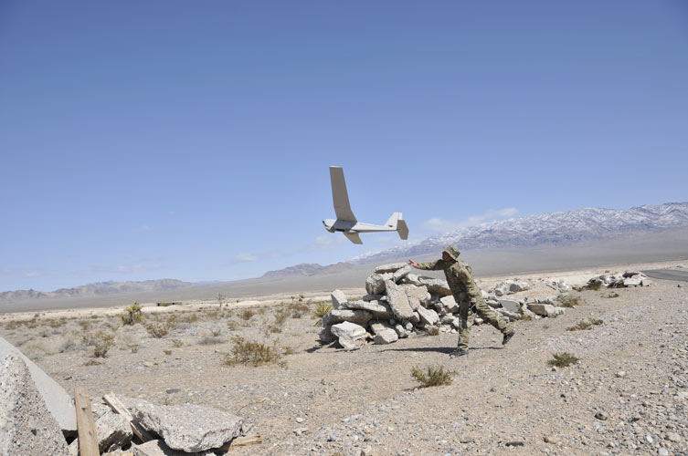
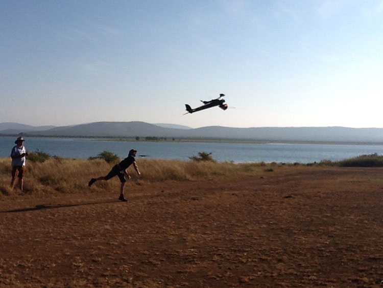
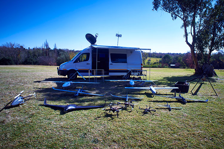
    Poachers operate at night, when park rangers equipped with conventional aircraft can’t fly. Air Shephard searches for poachers using predictive analysis to determine the behavior patterns of both animals and poachers. Small drones with cameras search likely areas — once poachers are identified, pre-positioned rangers can intercept the suspects.

    The hand-launched UAVs carry high-resolution cameras for both daylight and nighttime infrared scanning. At operating altitude, they can easily tell the difference between animals and humans, and transmit real-time geolocation information to the operating team on the ground. The UAVs fly for more than 1.5 hours; they are clean, stealthy and provide an eye-in-the-sky capability.

    UAV fleet deployed around an Air Shepard mobile operating center.
    UAV fleet deployed around an Air Shepard mobile operating center.

    The Charles A. and Anne Morrow Lindbergh Foundation, originator of the Air Shepherd Initiative, has partnered with a dedicated group in South Africa that, over the last two years, has flown more than 650 drone missions over one of the most sensitive rhino poaching areas in Africa. During that period, no rhinos were lost to poachers where the UAVs were flown.
    Once the process is proven, Air Shepherd expects it to be used in national parks and private reserves in South Africa and Botswana, then expand as funding increases to Namibia, Zambia, Tanzania, Gabon, Democratic Republic of the Congo, and eventually Asia.

    Learn more about the project at www.AirShepherd.org.

  • Army Gray Eagle conducts manned-unmanned exercise

    In August, U.S. Army Gray Eagle unmanned aircraft took part in manned-unmanned teaming exercises in South Korea, including streaming video and metadata to an AH-64 Apache helicopter while in flight.

    Exercise support was conducted from Kunsan Air Base, South Korea, and represent a milestone for the MQ-1C Gray Eagle, proving its ability to conduct operations in diverse weather condition, according to manufacturer General Atomics Aeronautical Systems (GA-ASI).

    During the exercise, the Gray Eagle UAS streamed video and metadata via a line-of-sight data link directly to the helicopter from extended distances. The Apache then retransmitted the imagery to a One System Remote Video Terminal (OSRVT), allowing field commanders within the Tactical Operations Center (TOC) to receive both live Gray Eagle streaming video and retransmitted video sent by the Apache. Once the Gray Eagle was airborne, U.S. ground forces passed contact reports and target coordinates to operators in the aircraft’s ground control station. The operators were then able to direct the Gray Eagle’s sensors to positively identify and track the targets.

    The Gray Eagle is used by the Army for reconnaissance, surveillance, communications, convoy protection, IED detection and precision weapons delivery.

  • FAA small unmanned aircraft registration begins

    The Federal Aviation Administration’s (FAA) Small Unmanned Aircraft System (UAS) registry is now live and ready for owners of hobby UAS to use at www.faa.gov/uas/registration. Registration is free for the first 30 days with a rebate, then $5 after that.

    The online registration system does not yet support registration of small UAS used for any purpose other than hobby or recreation — for example, using an unmanned aircraft in connection with a business. The FAA is developing enhancements that will allow such online registrations by spring of 2016.

    During the registration process, each owner must provide his or her name, home address and e-mail address. When registration is complete, the web application will generate a Certificate of Aircraft Registration/Proof of Ownership including a unique identification number for the UAS owner, which must be marked on the aircraft.

    Owners using the model aircraft for hobby or recreation will only have to register once and may use the same identification number for all of their model UAS. The registration is valid for three years.

    All aircraft weighing more than 0.55 pounds (250 grams) and less than 55 pounds (approx. 25 kilograms), including payloads such as on-board cameras, must be registered.

    Under this rule, owners who previously operated an unmanned aircraft exclusively as a model aircraft prior to Dec. 21, 2015, must register no later than Feb. 19, 2016. Owners of any other UAS purchased for use as a model aircraft after Dec. 21 must register before the first flight outdoors. Owners can use either the paper-based process or the new streamlined, web-based system. Owners using the new streamlined web-based system must be at least 13 years old to register.

    If assistance is needed with registration, email [email protected].

    The FAA also reminds unmanned aircraft owners there’s no need to work with a “drone registration” company to help file an application for a registration number. The registration site is designed to be simple and easy to use for every hobbyist.

    The FAA has partnered with several industry associations to educate the public about using unmanned aircraft safely and responsibly. Flight rules include:

    Fly below 400 feet altitude.

    • Keep your unmanned aircraft in sight at all times.
    • Never fly near manned aircraft, especially near airports.
    • Never fly over groups of people, stadiums or sporting events.
    • Never fly near emergency response efforts.
  • FAA unveils UAS rule, begins drone registry Dec. 21

    FAA unveils UAS rule, begins drone registry Dec. 21

    The Federal Aviation Administration announced on Dec. 14 an official rule and registration process for hobbyists who own small unmanned aircraft weighing more than 0.55 pounds and less than 55 pounds, including payloads such as on-board cameras.

    The online registration system does not yet support registration of small UAS used for any purpose other than hobby or recreation — for example, using an unmanned aircraft in connection with a business. The FAA is developing enhancements that will allow such online registrations by spring of 2016.

    The registration procedure is a statutory requirement that applies to all hobby aircraft. Under this rule, any owner of a small UAS who has previously operated an unmanned aircraft exclusively as a model aircraft prior to Dec. 21, 2015, must register no later than Feb. 19, 2016. Owners of any other UAS purchased for use as a model aircraft after Dec. 21, 2015, must register before the first flight outdoors.

    The Registration Task Force delivered recommendations to FAA Administrator Michael Huerta and Transportation Secretary Anthony Foxx on Nov. 21. The rule incorporates many of the task force recommendations, the FAA says.

    “Make no mistake: unmanned aircraft enthusiast are aviators, and with that title comes a great deal of responsibility,” Foxx said in the announcement. “Registration gives us an opportunity to work with these users to operate their unmanned aircraft safely. I’m excited to welcome these new aviators into the culture of safety and responsibility that defines American innovation.”

    Owners may register through a web-based system or paper-based process. There is a $5 registration fee, but the FAA is offering a full rebate for those who register before Jan. 20, 2016.

    Under the rule, each aircraft must be marked with a unique number, although not necessarily the serial number. The goal is to help authorities track down an owner if a drone collides with another aircraft, flies too high or encroaches on an airport.

    Registrants will need to provide their name, home address and email address. Upon completion of the registration process, the web application will generate a Certificate of Aircraft Registration/Proof of Ownership that will include a unique identification number for the UAS owner, which must be marked on the aircraft.

    Owners using the model aircraft for hobby or recreation will only have to register once and may use the same identification number for all of their model UAS. The registration is valid for three years.

    “We expect hundreds of thousands of model unmanned aircraft will be purchased this holiday season,” Huerta said. “Registration gives us the opportunity to educate these new airspace users before they fly so they know the airspace rules and understand they are accountable to the public for flying responsibly.”

  • FLYPRO announces smartwatch-controlled XEagle drone

    FLYPRO announces smartwatch-controlled XEagle drone

    Shenzhen FLYPRO Aerospace Tech Co. has officially released the XEagle, an unmanned aerial vehicle (UAV) equipped with auto follow and obstacle avoidance functions.

    Photo: FLYPRO Aerospace Tech Co.Unlike other popular self-flying drone models on the market that are taken off by throwing the aircrafts in the air, which increases the risks of crashing the vehicles, XEagle introduces various features including voice control, smartwatch and automatic obstacle avoiding to offer a better user experience. By liberating both hands, users do not need to have any previous knowledge and experience when handling an XEagle.

    Designed for recording sports activities, FLYPRO has replaced traditional UAV remote controllers with XWatch for the new XEagle. XWatch is a smartwatch designed to control XEagle that’s portable and easy to navigate — users can control the devices to take off, land and follow, as well as adjust flight height with just one click on the wrist within 300 meters. The smartwatch design enables users to fly the aerial vehicles to take high-definition pictures and videos while engaging in intense sports such as skiing and mountain bike cycling.

    The voice control feature allows hobbyists to fly the XEagle without moving their hands at all — the built-in intelligent voice recognition system responses fast and accurately to commands in both Chinese and English. Users only need to instruct the XEagle with commands such as “FLYPRO, take off” and “FLYPRO, follow me” to launch the XEagle in the air and have it follow automatically.

    To lower the risk of crashing the UAV in both takeoff time and during flight, XEagle offers a crash prevention solution by installing four layers of protection. With an infrared obstacle avoidance system and built-in photoelectric sensors, the XEagle can calculate precisely and in real time for obstacles to avoid collisions. The detection is effective when the obstacle is at the distance between 0.1 to 15 meters with relative velocity of 12 meters per second. The UAV can dodge obstacles and barriers while flying in the air by changing its flight path automatically.

    As a newcomer in the UAV market, FLYPRO’s technological breakthrough in developing consumer drones not only resolves the safety concerns customers have with other similar UAVs, but also improves user experience through innovative control measures that makes flying the drones as easy as clicking a button, leading the UAV industry with the company’s user-centered philosophy and high product quality standards.

    “Now, customers favor UAV products with lower risks associate with operating the aerial vehicles as well as technological innovations that enable users to perform complex tasks without advanced training. When other companies are looking for ways to make UAV products more accessible to the public, FLYPRO has already achieved that with our innovative functions like smart watch control, auto follow and obstacle avoidance that allow everyone to enjoy flying the UAVs for sports and entertainment,” said Lin Hai, founder and CEO of FLYPRO.

  • Lockheed Martin conducts collaborative unmanned systems demonstration

    Lockheed Martin conducts collaborative unmanned systems demonstration

    Lockheed Martin has demonstrated its ability to integrate unmanned aircraft system (UAS) operations into the National Airspace System (NAS) using its prototype UAS Traffic Management (UTM) capabilities.

    During the demonstration on Nov. 18, the Stalker XE UAS provided data and a precise geolocation to the unmanned K-MAX cargo helicopter, which conducted water drops to extinguish a fire, while the UTM tracked the UAS operations and communicated with Air Traffic Control in real time.

    The Stalker UAS directs the unmanned K-MAX cargo helicopter to conduct water drops at a precise location to extinguish a fire. (Photo: Lockheed Martin)
    The Stalker UAS directs the unmanned K-MAX cargo helicopter to conduct water drops at a precise location to extinguish a fire. (Photo: Lockheed Martin)

    “This demonstration represents the path forward for flying UAS in the NAS using Flight Service-based UTM capabilities to extend the technology and systems that air traffic controllers know and understand,” said Paul Engola, vice president, Transportation & Financial Solutions. “We were able to successfully modify the existing K-MAX and Stalker XE ground control software to connect to the UTM services and conduct the firefighting mission.”

    For more than 80 years, manned aircraft have supported firefighting missions during daylight hours. Because unmanned K-MAX can fly day and night, in all weather, its insertion into firefighting operations offers the potential to triple the amount of time ground firefighters can receive aerial support.

    The Stalker XE UAS worked in tandem with K-MAX to identify hot spots and fire intensity with its electro-optical, infrared camera. Its stable, high-definition imaging capabilities enable day and night operations. Powered by a ruggedized solid oxide fuel cell, Stalker XE achieves more than eight hours of flight endurance.

    The Stalker and K-MAX operated in collaboration with a prototype UAS Traffic Management (UTM) system, which provides essential capabilities to enable safe UAS operations. (Photo: Lockheed Martin)
    The Stalker and K-MAX operated in collaboration with a prototype UAS Traffic Management (UTM) system, which provides essential capabilities to enable safe UAS operations. (Photo: Lockheed Martin)
  • Expert Opinions: FAA UAV registration requirement

    Q: What do you think of the FAA requirement that all UAV purchasers register their devices?

    Lydia Bock President and CEO Geodetics Inc.
    Lydia Bock
    President and CEO
    Geodetics Inc.
    A: We need a pragmatic and sensible response to the integration of UAVs into the civil airspace, balancing safety of civil aviation and the economic benefits associated with the emerging markets and applications of UAV technologies.

    Clearly maintaining flight safety in the national airspace is critical. A balanced approach would include registration of UAVs, education for hobbyists and FAA flight certifications for commercial operations.

    New technologies for automated sense-and-avoid should be investigated, and their certification for use should be streamlined.


    John Studenny Director System Engineering Esterline - CMC Navigation Systems
    John Studenny
    Director System Engineering
    Esterline – CMC Navigation Systems
    A: Registration of all radio-controlled (RC) aircraft or UAVs upon purchase may be too broad or harsh, and may conflict with current freedoms already enjoyed by hobbyists.

    However, as capabilities (altitude, speed, flight duration, payload capacity) increase beyond what today’s RC aircraft or UAVs can deliver, regulations and registration may be required.

    It comes down to UAV capability and how the UAVs are used. That needs to be the focus of any regulation or enforcement.

  • Topcon and Agisoft sign partnership agreement for UAS photogrammetric software

    Topcon Positioning Group announces a new partnership with digital photogrammetric solution provider Agisoft LLC. The agreement is designed to further expand the Topcon solutions portfolio for mass data collection (MDC).

    Topcon_Agisoft-WAgisoft is a world leader in the processing of digital imagery in order to generate high-accuracy 3D spatial data using photogrammetric and computer vision techniques, and has been developing imaging solutions for nearly 10 years. Topcon will provide the Agisoft Photogrammetric Kit for Topcon — Professional Edition software for post-processing of data collected using the Falcon 8 and Sirius Pro unmanned aerial systems (UAS).

    Features include photogrammetric triangulation, dense point-cloud editing and classification, digital terrain or surface model export to a variety of formats including georeferenced orthomosiac production (including GeoTIFF and KML export), multi-spectral imagery processing, 3D model generation and texturing, as well as full measurement analysis tools.

    “We are very excited to be able to offer the combination of our Sirius Pro and Falcon 8 UAS devices and Agisoft Photogrammetric Kit Professional software. The solution provides an integrated workflow for reaching high-accuracy survey results using unmanned aerial systems with minimal field work,” said Eduardo Falcon, executive vice president and general manager for the Topcon GeoPositioning Solutions Group. “For example, when using the Sirius Pro, absolute accuracies down to 1.6 cm (0.6 in.) in plan and 2.7 cm (1 in.) in height are possible without the need for any ground control.”

    The photogrammetric kit solution is now available.

  • DJI launches company’s first agriculture drone

    DJI launches company’s first agriculture drone

    Unmanned aerial vehicle maker DJI has launched of a smart, crop-spraying agricultural drone. The DJI Agras MG-1 is dustproof, water-resistant and made of anti-corrosive materials. It can be rinsed clean and folded up for easy transport and storage after use.

    The eight-rotor Agras can load more than 10 kilograms of liquid for crop-spraying and can cover between seven and 10 acres per hour. It is more than 40 times more-efficient than manual spraying, according to DJI. The drone can fly up to eight meters per second and adjusts spraying intensity to flying speed to ensure even coverage.

    The Agras features DJI’s flight-control system and microwave radar to ensure centimeter-level accuracy. During flight, the drone scans the terrain below in real time, automatically maintaining its height and distance from plants to ensure application of an optimal amount of liquid. DJI’s real-time Lightbridge 2 transmission system is also onboard.

    DJI-ag-drone-1
    The DJI Agras MG-1.

    Users can select automatic, semi-automatic or manual operation modes, depending on terrain, with uniform spraying carried out via the drone’s nozzles. The drone has four replaceable, ceramic nozzles, each powered by a motor. The included nozzles can be used for thousands of hours of spraying. Downward airflow generated by the rotors increases spraying velocity and ensures the agent will reach plant stems and leaves near the soil.

    The Agras MG-1’s body is sealed, and features an integrated centrifugal cooling system designed to extend motor life by up to three times. Triple-filtration cuts off intake of mist, dust and large particulates to reduce wear from impurities. As the drone flies, air enters the aircraft body via the front inlet. It is then filtered and passes through each of the aircraft’s arms to the motors, capturing heat from all components and the entire structure. Heat is then dissipated by venting into the surrounding air.

    DJI-ag-drone-2
    The DJI Agras MG-1 is designed for crop spraying.

    The drone’s intelligent memory function means after the Agras MG-1 is brought back to base for refill or recharge, it will return to its last memory point to pick up spraying where it left off.

    Users control the Agras with a custom DJI remote. Its low-energy display panel gives real-time flight information and lasts for extended periods on a single charge.

    The Agras MG-1 will initially be available in China and Korea and later in other markets.

  • AeroVironment Gets $13M UAV Order from U.S. Marine Corps

    A Puma AE being launched.
    A Puma AE being launched.

    AeroVironment has received an order valued at $13 million for RQ-20A Puma AE small unmanned aircraft systems (UAS) and initial spares packages for the United States Marine Corps.

    The Marine Corps employs the Puma AE system as the long-range solution for its small unit remote scouting system (SURSS), complementing the AeroVironment RQ-11B Raven and RQ-12A Wasp AE UAS.

    The Puma AE unmanned aircraft system delivers situational awareness directly to its operator in ground, to help provide information superiority on the battlefield.

    AeroVironment received the order from ADS Inc. on behalf of the U.S. Marine Corps through the Defense Logistics Agency Tailored Logistics Support program. Delivery is scheduled within 12 months.

    The Puma AE weighs 13.5 pounds, operates for more than 210 minutes at a range of up to 15 kilometers, and delivers live, streaming color and infrared video as well as laser illumination from its pan-tilt-zoom Mantis i23 AE gimbaled payload.

    Launched by hand and capable of landing on the ground or in fresh or salt water, the Puma AE provides portability and flexibility for infantry, littoral or maritime reconnaissance operations.

  • FAA’s Drone Task Force Issues Registration Recommendations

    A proposed national drone registration system should be based on the pilot, not the craft, recommends an FAA task force. It should also be free, electronic and immediate, and not apply to UAVs weighing 250 grams or less.

    In October, U.S. Transportation Secretary Anthony Foxx and Federal Aviation Administration (FAA) Administrator Michael Huerta announced the creation of the task force to develop recommendations for a registration process for unmanned aircraft systems (UAS).

    The Task Force agreed that it was outside its scope to debate the Department of Transportation (DOT) Secretary’s decision to require registration of sUAS or the legal authority for the implementation of such a mandate.

    Immediately following the DOT’s announcement in October, the FAA brought together retailers, pilots, industry representatives and others to talk about the proposal and submit comments on how the system should work.

    Task force members interviewed FAA officials, met for three days and prepared final recommendations. They agreed on three basic requirements: Owners must fill out an electronic form, immediately receive a certificate of registration and number for use on all UAVs they own, and mark all applicable drones with a registered number.

    The Task Force recommendations for the registration process are:

    1. Fill out an electronic registration form through the web or through an application (app).
    2. Immediately receive an electronic certificate of registration and a personal universal registration number for use on all sUAS owned by that person.
    3. Mark the registration number (or registered serial number) on all applicable sUAS before their operation in the National Air Space (NAS).

    The Task Force recommended an exclusion from the registration requirement for any small unmanned aircraft weighing a total of 250 grams or less. The exclusion was based on a maximum weight that was defined as the maximum weight possible including the aircraft, payload, and any other associated weight. In manned aircraft terms, it is the “maximum takeoff weight.”

    Read the report here.


  • SkyTracker Launched to Thwart Drone Threats in Protected Airspace

    CACI International has released SkyTracker, a precision system to protect high-value assets and support public safety against the escalating threat posed by the inadvertent or unlawful misuse of unmanned aircraft systems (UAS).

    SkyTracker’s UAS detection, identification, and tracking system uses the drone’s radio links to precisely identify and locate UAS flying in banned or protected airspace, and has the unique capability to locate UAS ground operators. This proprietary CACI technology has been demonstrated to address a variety of UAS threat scenarios. The system is widely applicable, from protecting airports to safeguarding critical infrastructure or events — anywhere UAS pose a potential risk to people or assets.

    On Oct. 7, the FAA announced a Pathfinder agreement with CACI to test SkyTracker in the airport environment to ensure successful operation without disruption of airport communications.

    SkyTracker accurately detects, identifies, and tracks UAS threats. The system’s mitigation capability provides responders with precise information in a defined geographic location in order to initiate countermeasures that, unlike other technologies, do not interfere with legitimate electronics or communications systems in the area, or with UAS that are being operated responsibly as determined by the U.S. government.

    SkyTracker_sensors_900pxThe SkyTracker system design is modular and scalable for application in different environments. It can protect high-value assets in geographically compact locations such as government buildings, embassies and stadiums, as well as provide wide-area defense of airports, military bases and areas under temporary flight bans such as locations experiencing forest fires. SkyTracker provides continuous, automated monitoring, day or night, in any weather condition.

    “CACI’s SkyTracker system provides our customers with the unique capability to precisely locate unmanned aircraft systems and their ground operators. Our system has been demonstrated to address a variety of UAS threat scenarios,” John Mengucci, CACI’s chief operating officer and president of U.S. Operations, said. “In addition to the protection of airports, an effort undertaken in our recently announced research and development agreement with the federal government, SkyTracker has broad applications in the protection of critical infrastructure, stadiums, events, or anywhere drones pose a potential risk to people or assets.”

    “CACI is proud to advance our SkyTracker solution to address the rapidly escalating threat posed by the misuse of unmanned aircraft systems,” said CACI President and CEO Ken Asbury. “The development of innovative technological solutions in response to complex security threats is in our DNA. We built SkyTracker to address one of the most complex challenges facing those responsible for protecting critical infrastructure.”

    CACI provides information solutions and services in support of national security missions and government transformation for intelligence, defense, and federal civilian customers. A Fortune magazine World’s Most Admired Company in the IT Services industry, CACI is a member of the Fortune 1000 Largest Companies, the Russell 2000 Index, and the S&P SmallCap600 Index. CACI provides dynamic careers for over 16,300 employees in 120 offices worldwide.