Google is reorganizing under a new name, Alphabet, separating its moneymaking businesses from its cutting-edge ventures such as the self-driving car and drone delivery service. The move is being made because Google’s penchant for experimentation made traditional investors nervous, according to the New York Times.
Alphabet would be the parent entity, housing several companies, with Google the biggest among them. Alphabet Inc. will replace Google Inc. as the publicly traded entity and all shares of Google will automatically convert into the same number of shares of Alphabet, with all of the same rights. Google will become a wholly-owned subsidiary of Alphabet.
“For Sergey and me this is a very exciting new chapter in the life of Google — the birth of Alphabet,” Larry Page, the chief executive of Google, wrote in a blog post on Monday. “We liked the name Alphabet because it means a collection of letters that represent language, one of humanity’s most important innovations, and is the core of how we index with Google search. We also like that it means alpha‑bet (Alpha is investment return above benchmark), which we strive for!””
“Sergey and I are seriously in the business of starting new things.” Page writes in the blog. “Alphabet will also include our X lab, which incubates new efforts like Wing, our drone delivery effort. We are also stoked about growing our investment arms, Ventures and Capital, as part of this new structure.”
Researchers at Qihoo 360, a Chinese Internet security firm, say they have found a way to make a GPS emulator that can falsify the location of smartphones and in-car navigation systems, reports Forbes. The system is inexpensive compared to expensive, sophisticated GPS emulators that can cost thousands of dollars.
Qihoo lead researcher Lin Huang is the first Chinese woman to present at the yearly hacker conference Defcon, held in Las Vegas on Aug. 6-9. Huang said her team used common software-defined radio (SDR) tools to create their module and software. They also used open-source software found on Github that had come from researchers at a Chinese university, along with their own code.
The SDR tools used include HackRF, described by Forbes as the $300 wireless Swiss army knife for hackers. The small board can move between radio frequencies, and read and transmit to a broad range of radio frequencies. On smartphones, the attack targets navigation signals delivered at the chipset level, on both Apple or Android smartphones.
Huang suggests that chipset manufacturers consider introducing new software that can better detect GPS spoofing.
One potential target of such spoofing is a drone., which could be commandeered by the spoofer and taken into restricted airspace. Alternatively, it’s possible to make drones believe they’re in a no-fly area.
The Qihoo team demonstrated such attacks using the free and open source GNU Radio, among other tools, to alter the GPS coordinates on a DJI Phantom 3. In a video at Forbes, filmed from a drone-mounted camera, the hackers force a UAV to crash land.
The researchers said the weaknesses could be fixed by DJI and other drone makers, but they would have to do so at the GPS chip level, meaning any drones already out there are unlikely to receive an update.
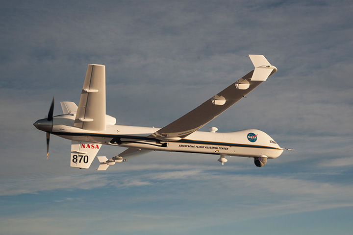
NASA’s Ikhana is being used to test a system that will allow uncrewed aircraft to fly routine operations within the National Airspace System. (Credit: NASA)
NASA plans to install a Locata network (LocataNet) as the core positioning technology for safety-critical unmanned aerial systems (UAS) research at its Langley Research Center in Hampton, Va., according to an announcement by Locata.
NASA Langley is tasked with performing rigorous and repeatable scientific evaluation of new UAS safety and technology concepts under development. The LocataNet will provide high-precision non-GPS-based positioning, navigation and timing (PNT) that is essential for this work. Known for its long history of aeronautics research, NASA Langley is a key center for UAS research and development. In June, one of Langley’s unmanned hexacopters (a drone with six rotors) delivered medical supplies to a clinic, the first such delivery by an unmanned drone.
Locata’s centimeter-accurate positioning will now assist NASA to develop and improve flight-critical technology systems that support air transportation safety, efficiency and performance. Langley’s extensive state-of-the-art facilities will be further enhanced with the installation of the LocataNet.
The NASA LocataNet is scheduled to be installed and commissioned before the end of 2015. Locata will supply the LocataLite Transmitters and Locata receivers required by NASA for the installation. Aviation-quality Locata antennas, developed by Cooper Antennas (UK) and previously used by the U.S. Air Force in its own military LocataNets, will also be installed. Locata engineers will support the physical installation, ongoing training and the future technical support required by NASA Langley for this world-first UAS deployment.
Locata Corporation has invented new terrestrial positioning networks which function as local, ground-based replicas of GPS. These networks can be thought of as “GPS hotspots,” according to the company. Locata has amassed 146 granted patents to date protecting these innovations, with many more patents in the works.
Locata is currently shipping commercial systems to demanding and professional end users such as the USAF, NASA, Leica Geosystems, and many others. Locata enables their integration partners to extend GPS-like positioning coverage to modern industrial, commercial, consumer and government applications in areas where GPS is erratic, jammed or unavailable.
“Locata is proud and delighted to have received an order for NASA’s first LocataNet. Globally significant installations like this prove Locata’s new technology is delivering unprecedented levels of performance to many important new applications,” said Nunzio Gambale, Locata CEO. “As our technology roll-out begins to gain pace, the exceptional value Locata brings to next-gen mobile apps has attracted interest from players all over the world. In fact, our list of relationships is now looking like a roster of the world’s crème-de-la-crème. I honestly can’t think of a better or more prestigious name than NASA to add to our growing partner list.”
“Our team is savoring the opportunity to work alongside NASA engineers and we’re excited that Locata will help advance the safety-critical performance of Unmanned Aerial Systems,” he continued. “Almost all future mobile devices or machines, be they on the road, in the air, on a mine site, in a port, in a warehouse, in your mobile phone, or part of the inevitable Internet of Things — all of them are critically dependent on pervasive, reliable, high-accuracy positioning. Locata is being leveraged into these next-gen systems because it’s clear that satellite-based solutions alone can no longer deliver what’s required. Soon, as we bring miniaturized Locata transmitters and receivers to market, our innovations will enable even greater advances in cutting-edge consumer, commercial, and government applications.”
NASA Testing Program. As part of its UAS research, NASA is testing a system that would make it possible for unmanned aircraft to fly routine operations in United States airspace. Through the agency’s Unmanned Aircraft Systems Integration in the National Airspace System (UAS-NAS) project, NASA, General Atomics Aeronautical Systems, Inc. (GA-ASI) and Honeywell International, Inc., are flying a series of tests which began on June 17 and will run through July at NASA’s Armstrong Flight Research Center in California.
“We are excited to continue our partnership with GA-ASI and Honeywell to collect flight test data that will aid in the development of standards necessary to safely integrate these aircraft into the National Airspace System,” said Laurie Grindle, UAS-NAS project manager at Armstrong.
This is the third series of tests that builds upon the success of similar experiments conducted late last year that demonstrated a proof-of-concept sense-and-avoid system. The tests engage the core air traffic infrastructure and supporting software components through a live and virtual environment to demonstrate how a remotely piloted aircraft interacts with air traffic controllers and other air traffic.
“This is the first time that we are flight testing all of the technology developments from the project at the same time,” Grindle said.
This series of tests is made up of two phases. The first is focused on validation of sensor, trajectory and other simulation models using live data. Some of the tests will be flown with an Ikhana aircraft, based at Armstrong, that has been equipped with an updated sense-and-avoid system, as well as other advanced software from Honeywell.
Other tests will involve an S-3B plane from NASA’s Glenn Research Center in Cleveland, serving as a high-speed piloted surrogate aircraft. Both tests will use other aircraft following scripted flight paths to intrude on the flight path the remotely-piloted craft is flying, prompting it to either issue an alert or maneuver out of the other aircraft’s path. These flights will also conduct the first full test of the traffic alert and collision avoidance system (TCAS II) on a remotely piloted aircraft.
During the June 17 test, which lasted a little more than five hours, the team accomplished 14 encounters using the Ikhana aircraft and a Honeywell-owned Beech C90 King Air acting as the intruder. A second test was flown the following day, with a total of 23 encounters. The project team plans to fly more than 200 encounters throughout the first phase of the test series.
“Our researchers and project engineers will be gathering a substantial amount of data to validate their pilot maneuver guidance and alerting logic that has previously been evaluated in simulations,” said Heather Maliska, Armstrong’s UAS-NAS deputy project manager.
The second phase of the third test series will begin in August and will include a T-34 plane equipped with a proof-of-concept control and non-payload communications system. It will evaluate how well the systems work together so that the aircraft pilots itself, interacts with air traffic controllers and remains well clear of other aircraft while executing its operational mission. The aircraft, which will have an onboard safety pilot, will fly an operationally representative mission in a virtual airspace sector complete with air traffic control and live and virtual traffic.
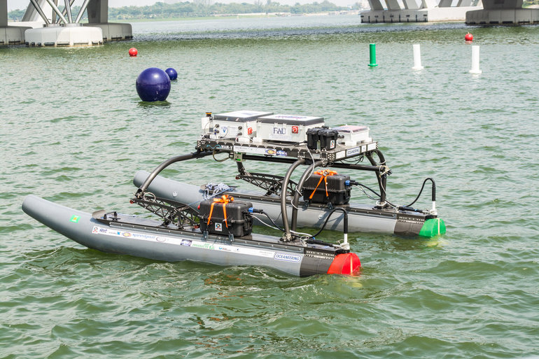
A research team at Florida Atlantic University’s (FAU) College of Engineering and Computer Science has received a $187,000 grant from the Florida Department of Transportation (FDOT) to develop autonomous waterborne vehicles that can assist in bridge inspections.
Although the technology is still in the early stages of development, the long-term aim is that the unmanned surface vehicles (USVs) could be used by the agency to make bridge inspectors’ work safer and more efficient, according to GovTech.com. FDOT currently uses a variety of methods and equipment to inspect and test the sections of the state’s 11,451 bridges that are above water level. However, the only method that can be used to check the sub-surface areas is divers, who search for cracks, erosion, damage and defects that might impact on a bridge’s safety. A high percentage of Florida’s bridges are in corrosive salt water, and divers frequently experience problems with low visibility from silt, sediment, debris and algae, weed or other plant matter.
The team from FAU’s Department of Ocean and Mechanical Engineering have experience in USV research, and won second place at the eighth annual International RoboBoat Competition in Virginia Beach, Va., according to GovTech.com.
Two months into a 12-month project, the team has upgraded a watercraft used for past research projects with a new propulsion system that allows the craft to maintain its position and heading during a bridge scan. The next phase of research will be to equip the craft with an acoustic scanning system that functions in a similar manner to a LiDAR (Light Detection and Ranging) system. By installing the scanner on a mount that can tilt and pan, researchers expect to obtain 3D models of the parts of the bridge that are below the water.
The current vessel is equipped with an automatic control system that uses GPS and a compass to direct the craft toward programmed waypoints, and can keep it steady in a variable current, allowing scanning to take place. Once the acoustic scanner is equipped in September, the team will begin testing the craft’s scanning capabilities on three bridges that have been recommended by FDOT for their diverse representation of the state’s bridge environments.
“These sorts of technologies aren’t really meant to replace wholesale divers and so forth,” the FAU project’s principal investigator, Karl von Ellenrieder, told GovTech.com. “It’s to make their jobs easier, and it’s another tool that can help them do their jobs better. The way I view it is, you would take a vehicle like this and it would allow you to more rapidly scan bridges, and then when you detect a problem, send out a diver to verify the problem through testing. If you’re going to send divers out into strong currents with nasty snakes and stuff, it’s better to have a good sense there’s a problem before you do that.”
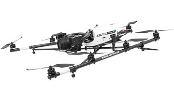
Topcon Positioning Group announces a worldwide distribution partnership with unmanned aerial system (UAS) provider Ascending Technologies. The agreement gives Topcon exclusivity for the global distribution of the AscTecFalcon 8 rotary-wing model, plus the GeoEXPERT and the InspectionPRO sensing and feature packages.
“We are excited to add the brand new Topcon Falcon 8, powered by Ascending Technologies, to our scope of aerial mapping solutions,” said Eduardo Falcon, executive vice president and general manager for the Topcon GeoPositioning Solutions Group. “By distributing both core target models on a worldwide level, Topcon can offer more end-users the flexibility and proven advances that these patented rotary-wing systems provide for survey, inspection and monitoring applications.” The Topcon-branded UAS includes the latest AscTecTrinity autopilot technology.
Based in Germany, Ascending Technologies is a developer and manufacturer of micro UAS for professional, civil and research use. “The AscTecFalcon 8 has been in series production since 2009 and still is the first choice UAS of world market leading inspection and surveying service providers,” said Jan Stumpf, one of the four CEOs and co-founder of Ascending Technologies.
“We are proud that our proven and advanced technology can now be easily accessed throughout the world. With the help of Topcon and its reseller network we can provide our high standards of support and customer service everywhere. This partnership gives us the freedom to continue the development of game changing technologies our customers need, while quickly extending our active fleet of reliable UAVs,” said Stumpf.
A Kentucky man shot down a drone when it crossed into “his airspace” over his backyard, and was subsequently arrested and charged with criminal mischief and wanton endangerment.
William Merideth told Ars Technia that he never would have shot the drone with Number 8 birdshot if it had only been flying past. But since it hovered, he felt it was an invasion of privacy. He claims the drone was flying 10 feet above his property and had been spying on his neighbor’s sunbathing daughter.
“It was just right there,” he told Ars. “It was hovering, I would never have shot it if it was flying. When he came down with a video camera right over my back deck, that’s not going to work. I know they’re neat little vehicles, but one of those uses shouldn’t be flying into people’s yards and videotaping.”
Merideth’s claims are disputed by the drone’s owner, who has evidence that rebuts Merideth. David Boggs, who was flying the drone, showed WDRB-TV a video of the flight path of the altitude of the drone, showing that the drone did not drop as low as 10 feet. Boggs, one of four owners of $1,800 drone, confronted Merideth and called police. Boggs told WDRB that he bought the drone just a few days before it was shot down and planned on using it to shoot video of his children riding motocross.
“I would just like [the drone owner] to get some education on his toy and learn to respect the rights of the people,” Merideth said. “It’s fine and dandy, and I think it’s cool there’s a camera on it, but just take it to a park or something — he’s not a responsible drone owner.”
In another incident involving drones and guns, an 18-year-old mechanical engineering student attached a semi-automatic gun to a quadcopter drone, and posted the result on YouTube in early July.
The video has been viewed more than 3 million times and was covered by the national media. The Federal Aviation Administration is investigating.
Peter Sachs, an attorney and drone advocate, welcomes the FAA investigation into the armed drone. “Drones should be used for good, not for evil,” Sachs said. “There are countless ways that drones can be useful. Using one as a remote-controlled weapon is not one of them, and I question the judgment of anyone who would attempt to do so.”
Amazon has announced a plan for its package-delivery drones, according to NBC News.
The proposal includes tiered flight zones that would limit small unmanned aircraft systems (sUAS) to slow speeds in airspace below 200 feet and allow them to fly faster for long-distance travel between 200 and 400 feet.
Commercial aircraft are governed by the Federal Aviation Administration’s (FAA’s) Air Traffic Control, and in Amazon’s vision, there would be a similar central command and control network that takes in data about the position of each drone and shares it with every other vehicle connected to the network. The command and control network would also have vehicle-to-vehicle communication, similar to networks proposed for autonomous automobiles.
Amazon’s plan would be to use the space below 500 feet — minus a 100-foot buffer — for small drones such as its Prime Air vehicles.
Access to the various layers of the airspace would be governed by how well a drone can communicate with its pilot, the command and control network and other drone, according to The Verge website. “Everyone can have access to the airspace,” said Gur Kimchi, who heads up Amazon’s Prime Air program. “It doesn’t matter if you’re a hobbyist or a corporation. If you’ve got the right equipment, you can fly.”
Someone operating a radio-controlled quadcopter with no Internet connection would be relegated to the area below 200 feet.
The University of Michigan (U-M) has opened Mcity, a controlled environment designed to test the potential of connected and automated vehicle technologies that will lead the way to mass-market driverless cars.
Mcity is a 32-acre simulated urban and suburban environment that includes a network of roads with intersections, traffic signs and signals, streetlights, building facades, sidewalks and construction obstacles. It is designed to support rigorous, repeatable testing of new technologies before they are tried out on public streets and highways.
“There are many challenges ahead as automated vehicles are increasingly deployed on real roadways,” said Peter Sweatman, director of the U-M Mobility Transformation Center (MTC). “Mcity is a safe, controlled, and realistic environment where we are going to figure out how the incredible potential of connected and automated vehicles can be realized quickly, efficiently and safely.”
In particular, Mcity allows researchers to simulate the environments where connected and automated vehicles will be most challenged. Even seemingly minor details a vehicle might encounter in urban and suburban settings have been incorporated into Mcity, such as road signs defaced by graffiti and faded lane markings.
The types of technologies that will be tested at the facility include connected technologies — vehicles talking to other vehicles or to the infrastructure, commonly known as V2V or V2I — and various levels of automation all the way up to fully autonomous, or driverless vehicles.
Mcity was designed and developed by U-M’s interdisciplinary MTC, in partnership with the Michigan Department of Transportation (MDOT). It is a public-private partnership among industry, government and academia. The center was established to lay the foundation for a commercially viable ecosystem of connected and automated mobility that will revolutionize the movement of people and goods worldwide. A key MTC goal is to put a shared network of connected, automated (including driverless) vehicles on the road in Ann Arbor by 2021.
“We believe that this transformation to connected and automated mobility will be a game changer for safety, for efficiency, for energy, and for accessibility,” Sweatman said. “Our cities will be much better to live in, our suburbs will be much better to live in. These technologies truly open the door to 21st century mobility.”
The facility also underscores Michigan’s emergence as a leader in advanced mobility, building on the state’s position as the global center of automotive research and development for more than a century, U-M said in a news release. Today, Michigan is home to 375 automotive research centers, and has the highest concentration of industrial and mechanical engineers in the country.
MTC is a public-private partnership among industry, government and academia. The center was established to lay the foundation for a commercially viable ecosystem of connected and automated mobility that will revolutionize the movement of people and goods worldwide. A key MTC goal is to put a shared network of connected, automated (including driverless) vehicles on the road in Ann Arbor by 2021.
MTC’s industry and government partners reflect the diversity of perspectives required to meet the challenges ahead. In the private sector, MTC partners include automakers and top-tier auto suppliers, but also traffic signal and traffic sensing companies, insurance providers, telecommunications, big data, IT and more. On the public side, MTC is working with federal, state and city governments.
“Mcity represents an important partnership between government at all levels, private industry and academia,” said Kirk Steudle, director of the Michigan Department of Transportation. “State of Michigan officials are thrilled to be part of this vital collaborative, which will ensure that Michigan continues to be the world’s auto leader.”
In addition to Mcity, MTC has three on-roadway connected and automated vehicle deployments underway. With the help of the Michigan Economic Development Corporation, MTC is building on a nearly 3,000-vehicle connected technology project launched three years ago by the U-M Transportation Research Institute to create a major deployment of 9,000 connected vehicles operating across the greater Ann Arbor area. MTC is also partnering with industry and the Michigan Department of Transportation to put 20,000 connected vehicles on the road in Southeast Michigan. The third piece of the plan calls for deploying a 2,000-vehicle mobility service of connected and automated vehicles in Ann Arbor.
MTC was launched in 2013 and Mcity construction began last year. About $10 million has been invested in the test facility, with funding coming from U-M and MDOT. Mcity will be available for use by any organization, but priority will be given to MTC partners and U-M faculty and students.
MTC is working with 15 Leadership Circle member companies, each investing $1 million over three years, and engaging in thought leadership. Thirty-three Affiliate Members are also contributing, and investing $150,000 over three years. Current Leadership Circle companies are:
In a striking contrast, the positive and negative sides of unmanned aerial vehicles were highlighted in a single day, July 17. First, in a government-approved demonstration, drones were used to deliver prescription medicine to patients at a temporary health clinic in rural Virginia, reports the Wall Street Journal. The event, reported previously by GPS World, aimed to show how UAVs can alleviate the problem of health-care access while creating economic opportunity for communities.
A manned aircraft carried the packages most of the way, and the flight plan originally called for the drone to make six round trips to carry a total of 10 pounds. But after two successful deliveries, officials decided to send the rest of the payload in one flight.
In stark contrast to that beneficial use of drones, efforts by firefighters to battle a fierce wildfire in California on July 17 were hampered by hobbyists flying consumer drones to capture video of the flames. Planes attempting to deliver water drops found their flights delayed or blocked by the presence of the drones, with private drones flying over the wildfire grounding firefighting aircraft for almost half an hour.
State lawmakers in California are drafting a bill that would impose heavy fines and potential jail time on anyone whose personal drone interferes with firefighting efforts.
GPS World held a webinar on new unmanned aircraft initiatives on May 21 led by a panel of experts. On hand were Don Mark of the law firm Fafinski, Mark and Johnson; James Spicer and Adrien Perkins, both students in aeronautics and astronautics at Stanford University; and Peter Cosyn site manager and director of research and development at Gatewing, a Trimble company. I also participated.
Alan Cameron, editor-in-chief and publisher of GPS World, hosted the event and introduced the participants. Around 300 people signed up to listen to the webinar and ask questions.
Don Mark provided a legal overview of the FAA’s regulations for UAS, FAA and U.S. Senate initiatives, James Spicer and Adrien Perkins reviewed the Jäger UAV jammer detection project, and Peter Cosyn provided an overview of the Gatewing/Trimble UX5 UAS solution. I provided insight into recent UAS industry.
Finally, the panel discussed a few of several written questions submitted by the webinar attendees. We promised to publish both these questions and our attempt at providing answers. Please bear in mind that this is new area of technology, applications and regulations governing operations — so we welcome clarifications and inputs as we may miss the mark occasionally!
Q&A for GPS World Webinar:
“New Frontiers in Unmanned Flight: Hey You, UAV!”
Is the FAA going to keep requiring a pilot’s license to operate a UAV?
The draft sUAS rulemaking proposed by the FAA does not require a pilot’s license. Instead, there’s a requirement to pass an aeronautical knowledge test, obtain an FAA UAS operator certificate and to pass an FAA knowledge test every 24 months. However, the Section 333 exemptions granted by FAA so far have all required that the operator have a private pilot’s license.
What are the effects (operational, legal) of GNSS receiver failures in UAV missions and what are some technical measures to avoid them?
Most UAS used within a critical or commercial operation not only carry GNSS, but also have some form of navigation back-up system — MEMS inertial being the most common — so navigation is still possible, albeit for a short time with any degree of accuracy. And in the event of a communications link failure, the norm is to have the UAV follow a pre-programmed “return-to-base” route, so the vehicle returns safely to a known location.
What is the development of UAVs in the healthcare industry?
There are a number of ongoing and proposed applications of drones that are health related. A prototype system in Delft, Netherlands, carries a defibrillator to be used to revive heart-attack victims. The concept is that a network of geographically distributed drones would be called from a cellphone, and the closest UAV would be dispatched and would be able to arrive much quicker than a conventional ambulance.
This drone is part of a prototype healthcare delivery system in Delft, designed to carry a defibrillator to heart attack victims and caregivers.
Other healthcare applications could include the rapid delivery of vaccines, medications and supplies delivered right to the source of an outbreak. This could more rapidly reduce the incidence of life-threatening communicable diseases. Communication equipment, mobile technology and portable shelters could be delivered in a rapid fashion to areas where critical infrastructure damage would prevent ground or typical air transport. Drones have also been used extensively in disaster relief efforts.
Also, in July, unmanned aerial vehicles will deliver medical supplies to a free health clinic in Wise, Virginia. The most urgent prescriptions will be provided by pharmacies located out of town. To get the medicine to the community as soon as possible, the pharmacies will deliver them to their local airport, where they will be collected by NASA’s fixed-winged aircraft and be flown to Lonesome Pine Airport. When the prescriptions arrive there, they will be loaded onto Flirtey drones and delivered to the Wise County Fairground. Flirtey drones are expected to deliver around 24 packages of prescription medication.
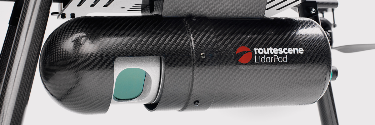
Please describe LiDAR systems available for UAVs.
There are many lightweight LIDAR systems on the market for UAV applications — some even come integrated within their own operational drone system. Coupling drone-mounted LiDAR systems with vision cameras, advanced computer processing and GPS, it has now become possible to create a remotely piloted flying LiDAR scanner.
Routescene’s LiDAR pod attached to the belly of a UAV.
Update us on legal matters within the European Union?
The EU has been very active in preparing for the commercial use of UAS, so drone use in the EU appears to be significantly higher than in North America because of the proactive effort of regulators to introduce drones into regular commercial applications. This Forbes article summarizes the approach being taken and the progress towards introducing regulations within the EU by the end of 2015.
You speak of “UAV navigation in environments where traditional GPS receivers may fail.” Are you considering indoors navigation or “just” urban environment?
It’s true that drones are being operated indoors — for instance, within restaurants. In these environments, all the typical indoor navigation techniques will be viable — RF/magnetic fingerprinting, Bluetooth beacons, Wi-Fi source databases, cellphone signals including small cells, and even optical sensors, all often combined with indoor maps.
Urban environments with a restricted view of the sky also continue to challenge GNSS only navigation, which has led to extensive use of integrated inertial/GNSS navigation sensors.
Modularity of UAVs? Different sensors for different types of applications using the same UAV?
A number of professional drone manufacturers offer UAS that could carry different payloads. However, most manufacturers seem to focus on particular applications (flying camera, LIDAR and/or video survey) and don’t carry an extensive range of optional third-party payload equipment.
What regulations are there for self-made UAS?
It’s hard to imagine that the regulations would be different for a commercially manufactured drone or a home-built UAS. Only time will tell as regulations are developed that include this category of UAS.
What background and abilities should a team possess if it wants to develop a UAV?
An engineering team that takes on developing a UAV needs to be aware of the basics of flight, navigation and control/communications — these are the principle elements of UAV operations.
Do you exploit software-defined radio techniques?
Software-defined radios may find their way into UAVs whenever weight/volume are an issue, but they potentially require higher computing capability, and maybe somewhat higher power to run co-processors. Weight and power consumption are at a premium on small UAVs, so any initiative that saves in these areas will no doubt be welcomed.
What are the emerging application areas for UAVs?
It would seem that the application areas for UAVs are virtually unlimited. High interest areas include agriculture, pipelines, buildings and transmission line inspection, aerial survey, filmmaking and newsgathering, wildlife and environmental monitoring, fishing and military reconnaissance/weapons delivery. But there are many, many applications, some of which might not fit into this summary of applications.
When will the UAV market move beyond focusing on the drone itself and get to the important topic of what sensor technology and back-office systems provide the best value to the user? The UAV is a commodity.
Good comment — the utility of the UAV comes from the payload it carries and the analysis of the data it collects and how it can be operated.
I’m curious if the UAV mission will be used in conjunction with autonomous agricultural tractors and construction machinery. I’m assuming an off-site tractor operator would benefit from the aerial data for their scope of work.
Absolutely — another possible UAV application.
Do you know when high-altitude long-endurance solar-powered UAVs will start being used?
The key application being pursued by Google using high-altitude, long-endurance, solar-powered drones is to provide Internet coverage in areas that currently have no ground infrastructure. A number of countries around the world would benefit from connection to the Internet using this approach. Unfortunately, the prototype aircraft built by Titan Aerospace recently crashed. But Google has vowed to continue with its efforts. Another development, called Project Loon, involves the use of high-altitude balloons and is already well underway.
I am currently enrolled in the UAV Pilots Certificate Training Program offered through the Unmanned Vehicle University. Is this certificate, which costs $3500, going to actually benefit me in my future commercial operations? Does the FAA recognize it as anything valid? So unless the certificate provides me some practical advantage, I’m not sure if it was legitimate or a scam. Any thoughts on this or experience with this “University”?
A recent Senate bill seeks to establish the six FAA test centers as the authorities for training UAS pilots. However, it would appear that currently no universal training course has yet been developed or approved for UAS pilot training — so it may be premature at this stage to engage with third parties for training until guidelines are published by the FAA.
What is the positional uncertainty associated with the locational measure of GPS systems on these UAVs? What will it be in five years?
Depending on the application, accuracies between 1 meter and a few centimeters are being achieved. For higher accuracy requirements such as precision surveying, post-processing of data collected during a survey can provide accuracies within a few millimeters.
In five years’ time there will be more satellites in more constellations, and it’s possible that accuracies could improve further. However, the most benefit will come from having more reliable signals, more often, thereby reducing re-test and operational costs.
What industry do you see being the fastest adopter of UAV technology in the USA?
The U.S. military is already leading in the number of applications, number of operational UAS and number of different types of vehicles. Commercial applications have increased substantially now that the FAA has authorized a large number of civilian operations in the last year or so. There are a number of film and TV applications for movie-making and newsgathering, and this appears to be a growing area for commercial UAS. Aerial survey is also growing in popularity, and there is a huge range of monitoring applications for building inspection, pipeline and transmission line inspection, and also for crop growth monitoring — which may turn out eventually to have the highest number of applications in the U.S.
How do you think the industry should protect UAVs from GPS spoofing and other forms of remote or internal component (example ICS or SCADA) attacks?
Solutions to mitigate GNSS spoofing and signal jamming are currently high on the list of most receiver manufacturers’ development agendas, with several options already having reached the market. Anti-jam antennas, improved signal rejection in RF front ends, and algorithms that claim to be able to deduce and overcome spoofing attacks — these are the leading solutions that have been fielded. But we have only just scraped the surface of deceptive techniques being used and the frequency with which they are being encountered, so we should continue to see the solutions evolving to counteract more sophisticated interference and spoofing capabilities over time.
Will the upcoming regulations only impact commercial users, or will they also directly affect non-commercial and/or recreational operators?
In the U.S., regulations governing the operation of recreational or hobby aircraft appear to be less stringent than, say, a drone operating commercially. As long as common sense rules are observed, hobby aircraft operators have been able to operate without the FAA looking over their shoulders — provided they stay below 400 feet in an open space away from sensitive areas such as schools or hospitals and don’t make an inordinate amount of noise, no one has yet proposed more restrictions for hobbyist model aircraft operators. The focus for the FAA is currently on bringing drones safely into the national airspace system for commercial operations, so regulations so far have been mostly formulated to enable this to happen.
Proposed legislation in the USA refers to one pilot per vehicle; no mention is made of swarming or control of multiple vehicles per pilot. Is it worth developing apps that use swarms of UAVs at the moment?
Certainly, it’s been difficult for the FAA to introduce regulations for UAS that are acceptable for most anticipated commercial operators, while still respecting and protecting current manned aircraft operations. So far, we’ve had case-by-case approval for specific operations, while regulations for small UAS (sUAS) have only just been circulated for comments — and a huge number of comments have been received. So regulations for “regular-sized” and operated drones and for larger vehicles have not yet seen the light of day. So, the more complex applications involving the operation of a swarm of UAS may not yet have been even considered by the FAA. It has taken years to get this far, and we still don’t have any published regulations for any class of UAS in commercial applications, so it’s doubtful that there is any work underway on regulations for swarming drones. So develop apps if you wish, but don’t expect much regulatory support for some time yet.
What assurance do we have that a UAV operator won’t deliver a weapon instead of an Amazon purchase?
The exemptions that have been published allow certain well-defined, specific commercial operations of UAS. The unmanned vehicle has to be registered to an individual and get a unique tail number. The operators have to be identified and must regularly demonstrate proficiency and adequate knowledge to become a recognized operator. So authorities get to inspect the UAV, know the owner and know the operator, and even get to review and approve the location of each UAS operation — not that that would prevent someone subsequently modifying the vehicle to carry ordinance, or knowingly attacking a target. It would, however, be pretty easy to track down the offender, but that doesn’t really prevent “weaponization” or delivery. But we are only at the small-vehicle-level currently, so its doubtful if major damage would be possible with small weapons, but an individual attack might still be lethal. Careful screening of individuals seems to be the route the regulators have taken to minimize this risk. This is still a difficult issue that is going to take some policing and close control.
Instead of an actual pilot’s license required for legal flight of a UAV, do you think an all-encompassing UAV pilot’s license will be required? I ask because I am a trained Trimble UX5 pilot, but I do not have my pilot’s license. I also build UAVs, and I am curious how I would get a UAV pilot’s license for a UAV I built? Unless they had an all-encompassing training course for pilot/flight safety.
The FAA proposed rulemaking for sUAS operations did not require operators to have a pilot’s license. Instead, UAS operators are required to undertake a specific recurrent training course for UAS operators, administered by FAA qualified trainers. Regulations relating to “home-built” UAS have yet to emerge, and may be some time away from publication.
It is said that mainland China has over 70% of the world UAV market? How did we fall so far behind?
Lack of regulations in the U.S. may have held back U.S. industry — see related comments by Amazon in testimony to the U.S. Congress.
But also the absence of restrictions in other countries may have helped overseas manufacturers get established and to gain initial market share. While the majority of done R&D was initially within the U.S., it’s clear that DJI and its Phantom line of drones have become very popular, very quickly. Strangely enough, the largest concentration of buyers and operators currently appears to be in the U.S.
Insurance against UAVs crashing and causing damage to humans: what progress has been made in this area?
Several insurance companies are now writing risk-coverage policies for UAS, including Global Aerospace, USAIG, Allianz and AIG.
We are operating a GNSS reference network in Greece, SmartNet-Greece (Leica Geosystems). Is there a tested NTRIP system on UAVs, to be connected and monitored to Ntrip caster? How could this augment real-time GNSS accuracy of UAVs?
Seems like you are trying to get RTCM corrections from a ground network to a flying UAV – correct? So do we need an Internet connection to get your ground network RTCM corrections onto the UAV? I’m not an expert on available mobile Internet hook-ups, but most smartphones have one, so it can’t be that hard to add this onto a UAV. Alternatively, wouldn’t it be easier to have the GNSS receiver on the UAV listen to a PPP broadcast from one of the several services providing these corrections? We could get down as far as 10 cm accuracy with one of these commercially available correction services.
Talk about the possibilities of precise positioning in UAVs, instead of mapping.
Precise real-time positioning on a UAV is a question of which GNSS receiver is onboard and which PPP or local RTK network transmissions are available in the area of UAV operations. Positioning accuracy is possible of a few centimeters down to a few millimeters post-processed.
Realistically, how close are we to being able to fly UAVs for commercial applications such as topographic surveys and earthworks applications such as mining sites?
As we heard during the webcast, obtaining an FAA section 333 exemption is quite possible for these applications, and some have already been granted. The FAA has been streamlining the process recently to reduce the time it takes to obtain these authorizations.
What is a practical ceiling for UAV flight?
The FAA has limited UAS operations to below 400 feet in the Section 333 exemptions that have been granted, while 500 feet is used as the maximum ceiling in the proposed draft sUAS regulations.
What is status of technology for “see and avoid” requirements for UAVs?
NASA, the Federal Aviation Administration (FAA), General Atomics Aeronautical Systems (GA-ASI) and Honeywell International Inc. have successfully demonstrated a UAS proof-of-concept sense-and-avoid (SAA) system. GA-ASI worked with NASA’s Armstrong Flight Research Center to integrate the new system aboard NASA’s Ikhana research aircraft, a civilian version of the company’s Predator B. The flight-test campaign in November and December 2014 evaluated the SAA system in a wide variety of collision-avoidance and self-separation encounters between two remotely piloted aircraft and various manned aircraft and included a sensor-fusion algorithm being developed by Honeywell.
NASA’s Ikhana Predator B drone.
An RTCA subcommittee is also working in parallel to develop the requirements for an SAA system, and these flight-test evaluations will contribute to those technical standards.
Other companies that are also thought to be active in SAA development include Rockwell/Collins, Sierra Nevada and Insitu/ Queensland University of Technology Australia.
So, a large number of questions on a pretty wide range of subjects — hopefully some of the answers we’ve provided will be of assistance — but please provide us with your comments if you have information to share.
Disclaimer: The statements, questions, views and opinions presented in this article are those of the author and webcast audience, and may not necessarily reflect the opinions of GPS World magazine, its owners or staff. Readers are also warned that the answers are provided on a best-effort basis and could be less than 100% correct.
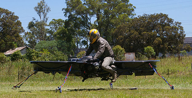
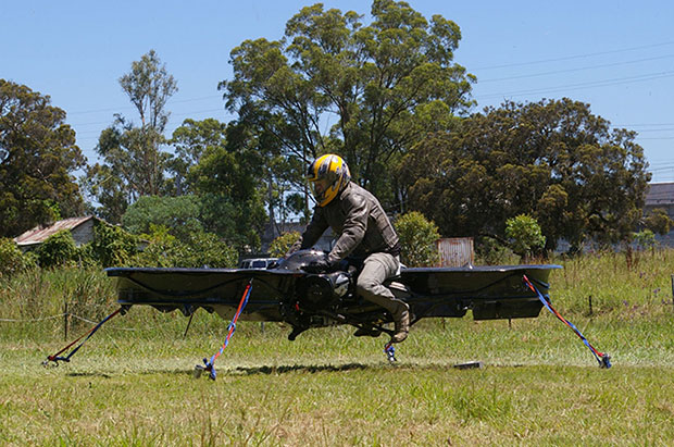
The hoverbike, shown tethered for safety reasons, supports nearly 600 pounds, enough for soldiers and their heavy gear. (Photo: Malloy Aeronautics)
Hover technology has long been depicted in movies like Star Wars and Back to the Future. Now the U.S. Army is teaming up with two companies to develop hoverbike technology — a cross between a motorcycle and a drone.
SURVICE Engineering Co., a Belcamp, Md.-based defense firm, and U.K.-based Malloy Aeronautics, an aeronautical engineering firm, are developing the Hoverbike technology for the U.S. Department of Defense as part of an ongoing research and development contract with the U.S. Army Research Laboratory. The Hoverbike is being developed to operate as a new class of Tactical Reconnaissance Vehicle (TRV).
The makers, Malloy Aeronautics, have a vision for the hoverbike beyond defense. “Its low cost and practical size lends itself to search and rescue, precision farming and cattle mustering, first-responder emergency services and cargo insertion of up to 120 kg (265 lbs) into confined spaces. We believe it would be ideal for ski and mountain rescue, airborne logistics and time-sensitive personnel insertion/extraction during major disasters,” the website says.
As part of this strategic alliance, UK-based Malloy Aeronautics has established a U.S. office in Belcamp adjacent to Aberdeen Proving Ground to complete work on the Hoverbike. A model of the Hoverbike is on display at the Paris Air Show, which runs through June 21.
Malloy’s Drone3, a prototype of the hoverbike, was funded through a kickstarter campaign and is now being sold. According to Malloy’s website, “A Californian customer of ours (Steve Mandel) received his Kickstarter Drone3 in February this year and emailed us yesterday with a photo of his new Drone3 in flight — with a new test pilot.” (Photo courtesy of Steve Mandel)
With about 400 employees, SURVICE is a specialty engineering firm that has been providing R&D support for the U.S. Department of Defense and other industry sectors for more than 30 years.
Formed in 2012, Malloy Aeronautics is an entrepreneurial aerospace company that develops, markets, and sells drones and Hoverbike technology to commercial and military markets.
The video below shows the second-generation Hoverbike in a unmanned static hover. While makers say it’s capable of lifting a person of at least 100 kg, for safety and legal reasons the vehicle is being tested as a drone.
“Establishing an office in Maryland was a clear business decision,” said Chris Malloy, managing director of Malloy Aeronautics. “The proximity to the Army Research Laboratory and U.S. defense decision makers, access to the world-class facilities through the laboratory’s Open Campus initiative, and the co-location with our strategic business partner, SURVICE Engineering, were all factors in favor of Maryland as the best choice for Malloy Aeronautics.”
“Maryland companies do a tremendous amount of research and development (R&D) for the U.S. military,” said Jeff Foulk, SURVICE chief executive officer. “If there is a new military technology being developed, there’s a good chance that some aspect was designed, built or tested in Maryland.”
The U.S. Army Research Laboratory is the nation’s premier laboratory for land forces and is part of the U.S. Army Research, Development and Engineering Command, which has the mission to develop technology and engineering solutions for America’s Soldiers. RDECOM is a major subordinate command of the U.S. Army Materiel Command.
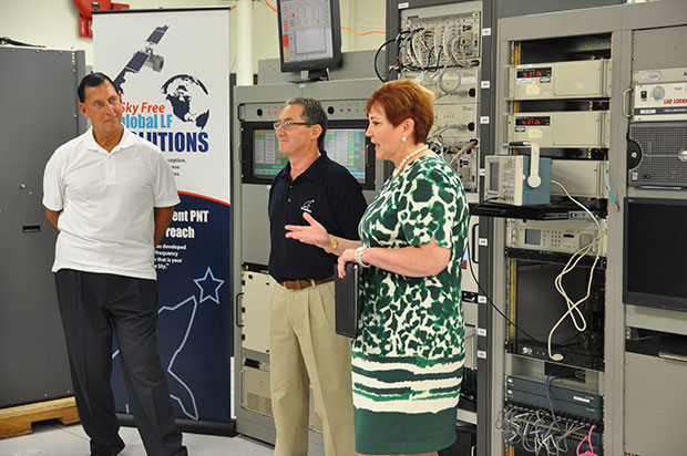
(fFrom left) Congressman LoBiondo, UrsaNav CEO Chuck Schue and Harris Division President Pam Drew. (hoto Credit: Andrei Grebnev, UrsaNav)
As of June 19, eLoran is on the air in the United States. The low-frequency signal emanates from a single station, a former U.S. Coast Guard Loran Unit in Wildwood, N.J., which sports a 625-foot signal mast that has been out of action for five years. The signal is receivable at distances of up to 1,000 miles.
The facility began generating eLoran pulses at the press of a command button by Congressman Frank LoBiondo (R, N.J). Present for the ceremonial start of a 12-month demonstration and research program under the aegis of the Department of Homeland Security were project participants Charles Schue, CEO of UrsaNav; Pam Drew, president of Harris Information Systems; and Dana Goward, president of the Resilient Navigation and Timing Foundation.
Brief remarks delivered at the turn-on collectively made the key points that:
GPS services are essential to national and economic security, yet are vulnerable to disruption.
The eLoran navigation and communications signal has features that are complementary to GPS, making it difficult to disrupt; further, it could be an important part of enabling UAVs to fly safely in our airspace.
The U.S. Federal Radionavigation Plan cites not being critically dependent upon a single system for positioning, navigation, and timing as a national policy objective. The plan specifically identifies eLoran testing as an important step toward reaching that objective.
The two engineering companies, UrsaNav, a supplier of eLoran technology, equipment, and services, and Harris (which recently acquired Exelis), provide funding and technology for the tests supported by the U.S. Coast Guard, Department of Defense, Department of Homeland Security and other federal agencies under a Cooperative Research and Development Agreement (CRADA) announced in May.
The team will evaluate eLoran as a potential complementary system to GPS, exploring the capabilities and use methods of eLoran in depth to identify all strengths, capacities, and potential vulnerabilities of the technology. One goal of the CRADA is to reduce the size, weight, cost, power needs and other aspects of Loran, similar to what has evolved with GPS.
“This is a phoenix arriving. We have the opportunity to add 2015 technology to the older idea,” said Schue of UrsaNav, once Coast Guard commanding officer at the former Loran station. “A prudent mariner always has two systems to navigate.”
Dana Goward, also a retired Coast Guardsman whose non-profit Resilient Navigation and Timing Foundation is working on the project, stated that eLoran can attain positioning accuracy of six meters or better.
“We will explore many places eLoran can be deployed where GPS isn’t available such as deep canyons, through buildings, in foliage and under water,” added Harris Corp.’s Drew. “We’re involved with unmanned aerial drones, and eLoran could be key. There are applications for civilian and military uses.”
In this GPS World exclusive video, Admiral Thad Allen, former commandant of the U.S. Coast Guard, discusses PNT alternatives to GPS for navigation, including eLoran and the activation this week of the signal on the eLoran tower in New Jersey.
eLoran in Europe
Matters have moved a little further along in Europe. In 2013, the General Lighthouse Authorities of the UK & Ireland (GLA) established prototype eLoran Initial Operating Capability (IOC) in the United Kingdom, where eLoran now delivers PNT data at the 10-meter level from a network of high-power, low frequency, terrestrial transmitters.
“To get high accuracy from eLoran requires accurate calibration of Additional Secondary Factor (ASF) through measurement,” according to paper delivered at the Institute of Navigation’s 2015 Pacific PNT meeting. “Can eLoran Deliver Resilient PNT?” was authored by Nick Ward, Chris Hargreaves, Paul Williams, and Martin Bransby of the GLA.
The older Loran-C system suffered from significant positioning bias errors due to a number of radio frequency signal propagation delay factors, they write. “The Primary Factor (PF) is due to the signal travelling slower in air than free-space, the Secondary Factor (SF) is due to the presence of the Earth’s surface and the electrical properties of the oceans. Additional Secondary Factor (ASF) is due to the additional electrical resistance encountered by non-seawater terrain, land, mountains, deserts, and so on. PF and SF can be modeled, but to get high accuracy from eLoran requires accurate calibration of ASF through measurement.
“To do this,” they continue, “ASF surveying and mapping has been conducted along the port approach channels at Aberdeen; along the Firth of Forth; Middlesbrough; Hull and the Humber Estuary Traffic Separation Scheme (TSS); Harwich and Felixstowe; The ports of London, Medway and the approaches past the London Array wind-farm and also through the Dover Straits.
“To complement these services, seven differential-Loran (DLoran) Reference-Stations, one located close to each of these survey areas have been established. These stations monitor the time of arrival of the received eLoran signals, and generate differential-corrections that are broadcast via the Anthorn Loran Data Channel (LDC), to account for temporal variations in these ASF maps.
“Making use of these ASF maps, combined with the locally-produced differential corrections, can allow a maritime user of eLoran IOC to obtain position accuracy of the order of 10m (95%), within a radius of 30 to 50 km of the DLoran reference station.”
eLoran can deliver Resilient PNT and this has been demonstrated on several vessels.
Seamless handover from primary (GPS) to secondary (eLoran) positioning source has been successfully implemented.
Surveying and mapping of ASF has been carried out for several major ports and the required levels of performance demonstrated.
DLoran reference stations to correct for short-term, temporal variations have been installed and commissioned.
Good levels of performance have also been demonstrated for coastal voyage phase away from the ASF surveyed areas.
eDLoran in Rotterdam. The July 2014 issue of GPS World presented a cover story showing results of a newer version, enhanced differential Loran (eDLoran), yielding position accuracies of approximately 5 meters.
Potential GNSS Back-up Improves to GPS-Level Accuracy
A new enhanced differential Loran system demonstrates 5-meter accuracy not achievable by the current DLoran system, and requires less expensive reference stations. A prototype tested in Rotterdam’s Europort area uses standard mobile telecom networks and the Internet to reduce correction data latency — a key source of error — by one to two orders of magnitude.
By Durk van Willigen, René Kellenbach, Cees Dekker, and Wim van Buuren
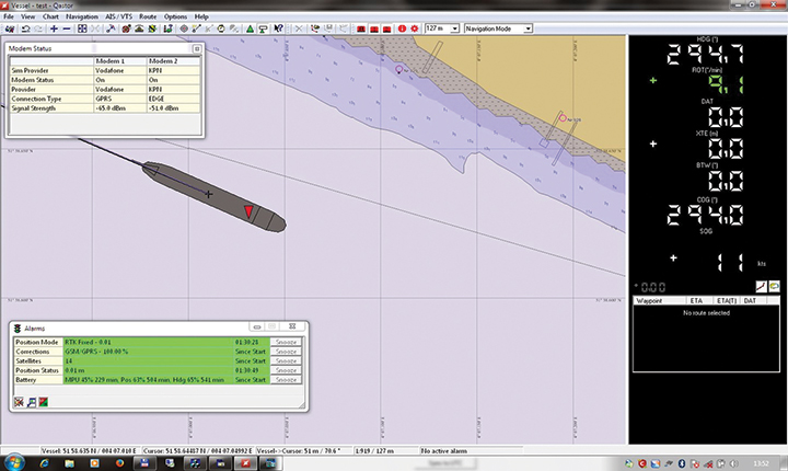
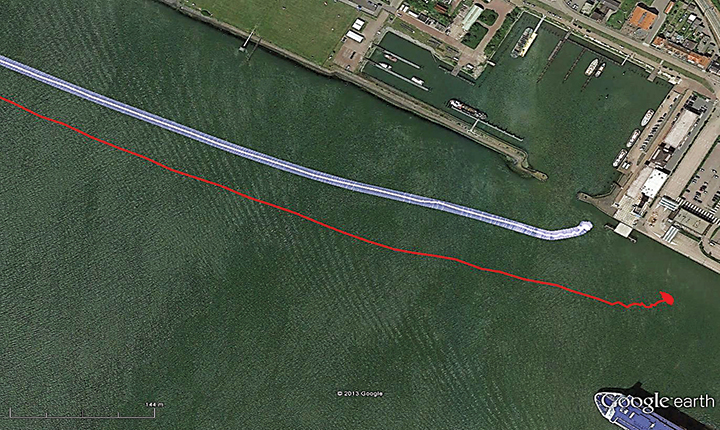
Figure 12. The large ship symbol (grey) is derived from the GPS-RTK receiver of the Rotterdam pilots. The width of the ship symbol is 10 meters and the speed-over-ground was 11 kts. The red triangle is generated by the eDLoran receiver and remains between the required ± 5 meter limits for eDLoran.Figure 13. The red track is based on raw eLoran data without any corrections. The transparent blue line is made by GPS-RTK and is widened to 10 meters giving the required ± 5 meter limits of eDLoran. The white line is output from the eDLoran receiver which stays within the borders of the 10 meter wide transparent blue line.
The GLA authors from the UK give a perspective on the Rotterdam project, as follows:
“A compatible system (eDLoran) has been developed for operation by ships’ pilots on the Europort approach to the Port of Rotterdam.
“However, Loran is a regional system dependent on international collaboration. The 9 transmitters in northern Europe are operated by Denmark, France, Germany, Norway and the UK.
“Both Norway and France have declared an intention to cease Loran transmissions at the end of 2015. Moreover, France intends to dismantle its Loran infrastructure in 2016. Arrangements for the commercial operation of the infrastructure are being investigated, but this depends on some form of regional agreement. The European Union appears to have no policy for resilient PNT, the European Radio Navigation Plan having twice been drafted but never published. The view seems to bee that the introduction of Galileo will achieve resilient PNT, which it will not.”
And Elsewhere
South Korea is implementing a national eLoran service, and it is understood that similar plans are being considered in Russia and China.