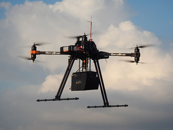
The U.S. Department of Transportation’s Federal Aviation Administration (FAA) has announced the largest civil penalty the FAA has proposed against a UAS operator for endangering the safety of the national airspace.
The FAA proposes a $1.9 million civil penalty against SkyPan International Inc. of Chicago. Between March 21, 2012, and Dec. 15, 2014, SkyPan conducted 65 unauthorized operations in some of the most congested airspace and heavily populated cities, violating airspace regulations and various operating rules, the FAA alleges. These operations were illegal and not without risk.
The FAA alleges that the company conducted 65 unauthorized commercial UAS flights over various locations in New York City and Chicago for aerial photography. Of those, 43 flew in the highly restricted New York Class B airspace.
“Flying unmanned aircraft in violation of the Federal Aviation Regulations is illegal and can be dangerous,” said FAA Administrator Michael Huerta. “We have the safest airspace in the world, and everyone who uses it must understand and observe our comprehensive set of rules and regulations.”
SkyPan operated the 43 flights in the New York Class B airspace without receiving an air traffic control clearance to access it, the FAA alleges. Additionally, the agency alleges the aircraft was not equipped with a two-way radio, transponder and altitude-reporting equipment.
The FAA further alleges that on all 65 flights, the aircraft lacked an airworthiness certificate and effective registration, and SkyPan did not have a Certificate of Waiver or Authorization for the operations.
SkyPan operated the aircraft in a careless or reckless manner so as to endanger lives or property, the FAA alleges.
SkyPan has 30 days after receiving the FAA’s enforcement letter to respond to the agency.
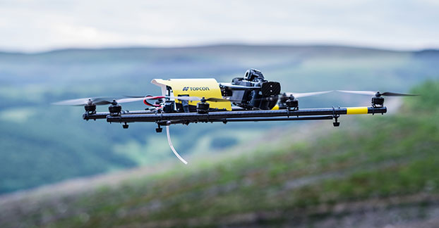
Topcon Positioning Group has added a rotary-wing unmanned aerial system (UAS) to its mass data-collection solutions line. The Falcon 8 — powered by Ascending Technologies — is designed for inspection and monitoring, as well as survey and mapping applications.
“Rotary-wing systems provide the perfect solutions for small-scale sites and projects for which flexibility of takeoff and landing or an oblique perspective is required,” said Charles Rihner, vice president of the Topcon GeoPositioning Solutions Group. “The Falcon 8 offers the flexibility to maneuver in small spaces and can cope with challenging environments often presented in inspection and monitoring. It is also well suited for smaller mapping or modeling projects up to 85 acres that require high-resolution imaging.”
The Falcon 8 features new AscTec Trinity technology, an autopilot safety feature that provides three levels of redundancy for protection against performance drop or loss of control. Three IMUs (inertial measurement system) synchronize all sensing data and identify, signal and compensate when needed.
Two models are available — the GeoEXPERT for surveying, modeling and mapping projects, and InspectionPRO for industrial inspection and monitoring applications. The GeoEXPERT includes a HD RGB camera payload, while the InspectionPRO features an HD RGB camera and infrared sensor combination.
“Both versions offer easy deployment and operation with real-time video and data monitoring capability, navigation software for planning and optimizing flights, as well as photo-tagging and desktop software to quickly generate high-quality and easy-to-edit material,” said Rihner.
The Falcon 8 complements the Topcon Sirius Pro fixed-wing UAS, providing large area accurate mapping without the requirement for traditional ground control.
Denver International Airport and the Federal Aviation Administration (FAA) are partnering to raise awareness about safe unmanned aircraft operations.
The agencies teamed up on a public service announcement that will run on the video towers in the airport’s main terminal. The PSA uses the “No Drone Zone” slogan to drive home the point that flying an unmanned aircraft near a manned aircraft is illegal and dangerous. It refers viewers to the FAA’s unmanned aircraft website and to the knowbeforeyoufly.org website for further information and guidance on flying unmanned aircraft safely and responsibly.
The PSA will air all day today following its unveiling at an unmanned aircraft safety press event that the airport organized and hosted. After that, it will air for two weeks surrounding the winter holidays — a time when many people will be getting drones as gifts.
Denver also will post the PSA on the airport website so it will reach travelers every day of the year.
The FAA has partnered with leading unmanned aircraft industry and hobbyist groups in the Know Before You Fly education campaign, and the campaign materials are now featured in product packaging for several types of UAS.
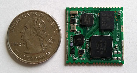
SkyTraq’s S2525F8-BD-RTK multi-constellation RTK receiver is designed for UAV and mobile platforms.
SkyTraq Technology, a fabless GNSS positioning technology company, is introducing the S2525F8-BD-RTK, a cost-effective, low-power single-frequency RTK receiver for unmanned aerial systems and mobile platforms requiring centimeter-level position accuracy.
The S2525F8-BD-RTK multi-constellation RTK receiver supports GPS, BDS, QZSS, and SBAS, simultaneously tracking up to 28 satellites. With its 25 x 25 millimeter form factor, 300-mW power consumption and 3 gram weight, it is designed for any outdoor applications requiring high-precision RTK positioning.
S2525F8-BD-RTK supports both base station and rover modes. As a rover, it receives RTCM 3.0 or 3.1 data from a base station, or raw measurements from another S2525F8-BD-RTK receiver serving as base station, and performs carrier phase RTK processing to achieve relative positioning with 1 cm + 1 ppm position accuracy within 10-Km baseline.
Its compact evaluation board has serial interface connector supporting direct connection to Ardupilot and Pixhawk autopilots for UAS testing. A Bluetooth 2.1 module is included on-board to simplify outdoor evaluation using Bluetooth-connected smartphone or tablet to receive remote base station data via NTRIP client software over the Internet.
S2525F8-BD-RTK engineering sample, datasheet, reference design and evaluation kit will be available in October. Volume production delivery to customer begins in November 2015.
Carrier-independent LTE modules, the autonomous vehicle and delivery drones all factor into future plans for the Swiss wireless company
Nick Papadopoulos
What’s new from u-blox?
There’s a ton of new things. One is that we are now expanding our portfolio into short-range radio, meaning we have now products that are Bluetooth- and Wi-Fi-capable, which is useful especially in the automotive industries.
And on another note, on the cellular side which we have been shipping since 2010, we have now introduced one a high-speed LTE module that is carrier independent in the United States so it can do both AT&T and Verizon at the same time so customers have the option as part of their logistics chain to build their product and not have to worry if this is an AT&T module now or a Verizon module. It simplifies logistics, simplifies the entire manufacturing chain and reduces cost.
What are some use cases for the carrier-independent module?
One of our customers builds devices—whether for alarm panels, tracking devices, telematics devices—where at the time of manufacture in the past they would actually have to determine for which carrier this particular device is going to made. So imagine the warehouse where they have to have one shelf for AT&T devices and another shelf for Verizon devices. It duplicates the effort. It costs money to have this kind of inventory, and you don’t know when you manufacture how many AT&T devices am I going to sell how many Verizon devices am I going to sell. That goes away. The same goes with tablets.
This is for the automotive market as well?
Imagine a carmaker who actually has a telematics control unit and they have an agreement say with one of the carriers—I’m not saying which—and two years down the road they have 8 million vehicles with telematics unit and then after two years decides the rates I’m getting with Carrier A, I could get better rates from Carrier B, so going forward they now sell vehicles car with telematics units with Carrier B. But everything they’ve sold in the past two years is still relying on Carrier A and, with the data buckets they have to pay still with that carrier, they don’t have any cost advantage there only moving forward. Now with our modem they can actually switch the entire base to Carrier B and save on the cost.
Can you tell us with whom you are working on this?
We are working with several customers on this and have a designed product, but I cannot tell you at this point until they allow us to—we’re working with them so it’s probably going to be the beginning of next year (before an announcement is made).
What do you think it is that is giving your automotive innovations longevity?
One of the things we have been working on is the development of our own LTE chipset and that has advantages–for one cost advantages—because LTE-only technology does not compete with our partners and so far that actually allows us to develop new products, new modules based on our own LTE chipset and expands our portfolio especially in North America where we hope in the next few years LTE will be so prevalent you won’t need any 2G or 3G, so that’s one of the things.
We have also announced we are working very closely on the positioning side with several carmakers toward technology for autonomous vehicles. We’ve revolutionized positioning technology to the point you can identify which altitude you’re at in a parking garage. That is expanding to allow additional accuracy in very adverse environments for preparation of so called ADAS systems toward autonomous vehicles.
What can we expect from this technology in the next few years?
You have already today cars that park themselves. You have already today cars that are autonomous, but there are still passengers there just to monitor. A lot of the technology that already there is actually based on our dead reckoning technology. We are expanding around that in order to eventually truly allow autonomous vehicles to the point where those vehicles can actually park themselves in a valet scenario.
Imagine driving up to a hotel and telling your car to go park yourself and it does it. It knows where to go and it eventually finds a spot and it parks itself without endangering anyone, and it can do that due to our technology, even underground. I do see in the next three-to-four years several carmakers launching vehicles that can drive autonomously on the highway. And they will need our technology for it.
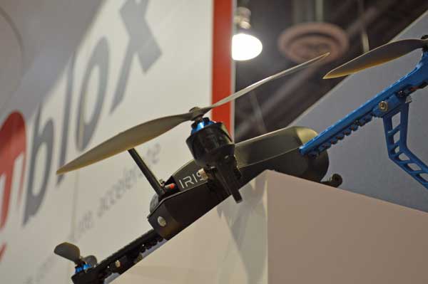
The IRIS+ drone utilizes the u-blox GPS module.
What about usage in UAVs?
We are the leader in positioning technology for drones. We’re developing the technology to further improve position accuracy for delivery drones. So not just for recreational use but truly for professional utilization either for delivery, package delivery, agricultural delivery, pesticide/herbicide delivery. You need very, very accurate positioning technology.
Where do you see the UAV industry going?
I see consolidation eventually but at the same time, I see more and more proliferation of companies developing new types of drones.
What’s the key to u-blox’s success?
We have been phenomenally lucky that we have such good customers, who are not only loyal to us, but they spread the word and they bring more customers. I am very thankful and grateful to our customers and colleagues.
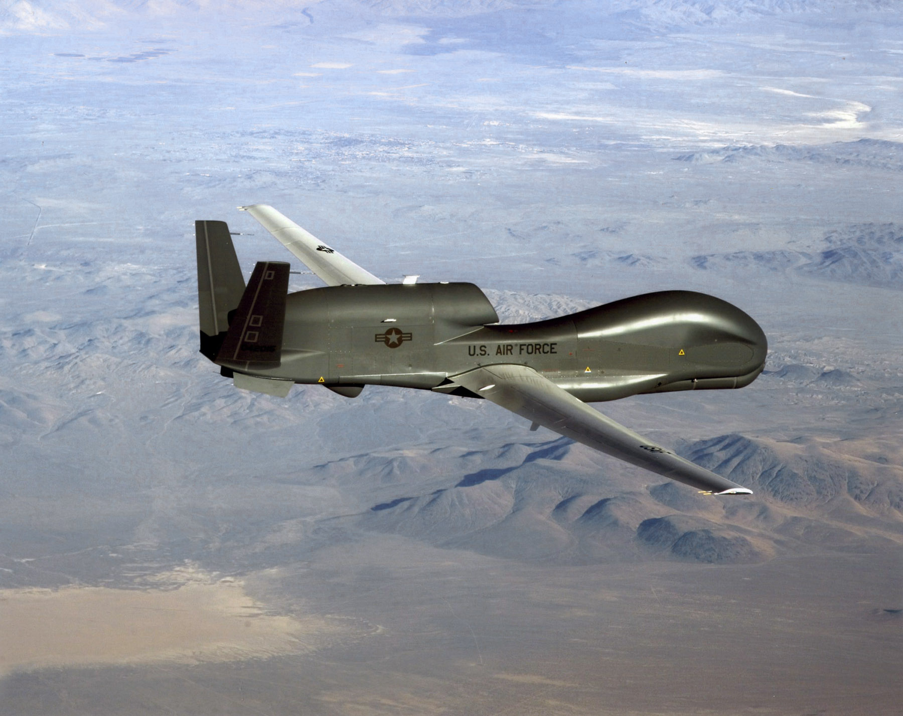
An RQ-4 Global Hawk soars through the sky to record intelligence, surveillence and reconnaissance data. (Courtesy USAF)
Curtiss-Wright Corporation’s Defense Solutions division was honored by Northrop Grumman for its role as a supplier in support of the RQ-4 Global Hawk unmanned aircraft system (UAS).
Global Hawk has flown 150,000 total flight hours supporting diverse global missions. Carrying a variety of intelligence, surveillance and reconnaissance sensor payloads, Global Hawk supports anti-terrorism, humanitarian assistance, disaster relief, airborne communications and information-sharing missions.
A ceremony was held Aug. 19 at Curtiss-Wright’s Integrated Systems facility in Santa Clarita, Calif., for the program to receive the James G. Roche Sustainment Excellence Award for a third year in a row. During the ceremony, an award was presented by Mick Jaggers, Global Hawk UAS vice president and program manager, Northrop Grumman Aerospace Sector, and accepted by Lynn Bamford, senior vice president and general manager, Defense Solutions division. The event was also attended by Rep. Steve Knight, U.S. Congressman for California’s 25th District.
(From left) Knight, Bamford and Jaggers with the award.
“We extend our sincerest congratulations to the US Air Force on this award and Northrop Grumman for their stellar job as the prime contractor on the milestone setting RQ-4 Global Hawk UAS,” said Ms. Bamford. “We take great pride in Curtiss-Wright’s role as an industry leader in providing advanced rugged electronics that help lower this important aircraft’s cost through the use of commercial-off-the-shelf technologies.”
During the ceremony, Jaggers remarked, “An aircraft as sophisticated as the Global Hawk comes together with the help of many partners, and one of the most crucial sustainment partners on the Global Hawk is Curtiss-Wright.”
The Sustainment Excellence Award is granted by Headquarters U.S. Air Force Logistics, Installations and Mission Support. It is named for Dr. James G. Roche, the 20th Secretary of the Air Force, a position he held from 2001 to 2005.
SBG Systems joins YellowScan to present a lightweight lidar with inertial and GPS for UAVs. The new product will be presented at the INTERGEO trade show in Stuttgart, held Sept. 15-17.
The YellowScan lidar is designed for fixed or rotary-wing UAVs, with an embedded Ellipse-E, a miniature inertial navigation system from SBG Systems, which helps obtaining a clear and accurate point cloud.
The UAV market is continuously growing, especially for professional applications like 3D surveying. Developed for such applications, YellowScan’s R&D team has worked closely with researchers and professionals in industries such as construction, surveying, mining and natural resources to create a comprehensive, high-performance and easy-to-use LiDAR.
Ellipse-E. The ready-to-use YellowScan is operational at up to 75 meters and delivers a highly dense point cloud accurate to 10/15 centimeter. The solution includes a lidar with a ±50 degree angle that measures 40,000 points per second, an Ellipse-E inertial navigation system coupled with a centimeter-level RTK GPS, an on-board computer, and an integrated battery.
The Ellipse-E miniature inertial navigation system by SBG Systems.
Once mounted on the drone, the user pushes the yellow button and YellowScan is ready to survey. LED lights give useful information on YellowScan state, for instance if the GPS is receiving RTK corrections or not. The user can launch the UAV and begin the survey. Once the task accomplished, a USB stick is used for downloading the data. An office software visualizes the point cloud in a few clicks, before opening it in an industry specific software like Terrasolid, AutoCAD or ESRI.
The YellowScan research and development team was searching for a high-performance, light and ITAR-free inertial navigation system for motion compensation and data georeferencing. They tested the Ellipse-E, the new miniature inertial navigation systems from SBG. Weighting 12 grams as an OEM version, it provides roll-and-pitch data accurate to 0.2 degree. The heading is accurate to 0.5° with only one antenna. Indeed, the heading computation relies on GPS and accelerometers data. This method is used when GPS positioning is widely available and punctuated by frequent accelerations, such as turns. The R&D team found the test results satisfying, and a point cloud highly clean. “We are very satisfied with this little Ellipse-E. It perfectly matches our technical needs, and we even gained 5 percent on the total weight of the YellowScan,” said Tristan Allouis, CTO at YellowScan.
Ellipse-E Coupled with External GPS Receiver. The Ellipse-E inertial navigation system is able to connect to any survey-grade GPS receiver and to fuse in real-time GPS position with inertial information. Ellipse-E maintains a reliable position even if GPS masks occur. In this application, the Ellipse-E is coupled with the AsterX-m OEM card from Septentrio, a receiver that uses GPS and GLONASS constellations and works with all types of RTK reference stations.
At INTERGEO, YellowScan will be in booth # F8.014, and SBG Systems will present the Ellipse-E at booth # G4.079.
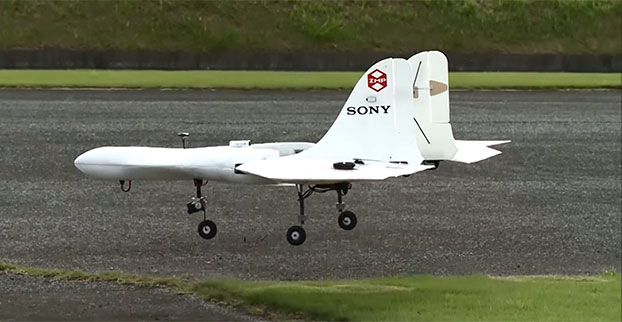
Sony is developing an unmanned aerial vehicle that lifts off and lands vertically like a helicopter (also known as a VTOL craft for vertical take-off and landing.) The VTOL drone is being developed with a Tokyo robotics firm under a collaborative company called Aerosense.
The drone can carry up to 22 pounds, fly continuously for two hours, and reach a speed of 106 miles per hour. Sony is developing it for business customers, who would use it for “measuring, surveying, observing and inspecting” as soon as next year, so it will likely carry different types of instruments, depending on the task a customer requires.
The video below shows a prototype flight on Monday.
Aerosense, created this month, is a joint venture between Sony and Tokyo-based startup ZMP Inc., which specializes in autopilot technology. The venture is part of Sony’s efforts to move beyond its core consumer products into enterprise markets. Aerosense will offer services such as inspecting aging infrastructure and surveying land that is difficult to access. The drones would be piloted automatically based on input from users about which areas they want surveyed.
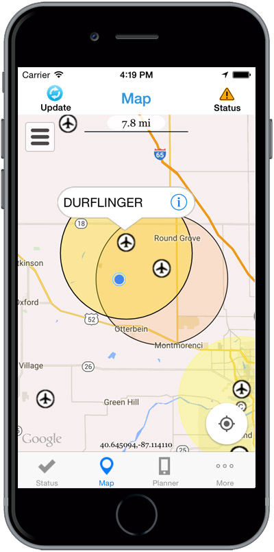
The Federal Aviation Administration (FAA) has released the beta version of a new smartphone application called B4UFLY for testing by up to 1,000 unmanned aircraft users.
The B4UFLY app, aimed primarily at model aircraft enthusiasts, is designed to give users information about restrictions or requirements in effect at their current or planned flight location. The FAA expects the beta test will yield valuable data on how well B4UFLY functions, as well as uncovering any software bugs.
FAA Administrator Michael Huerta first announced the initiative in May, asking for volunteers to test the app. The FAA has notified those who previously signed up and will be pushing the app to them directly in the coming days.
Many unmanned aircraft users today have little or no aviation experience, and some of them are flying where they could endanger manned aircraft. B4UFLY will give these flyers the tools and knowledge they need to operate safely.
Key features of the B4UFLY app include:
A clear “status” indicator that immediately informs operators about their current or planned location.
Information on the parameters that drive the status indicator.
A “Planner Mode” for future flights in different locations.
Informative, interactive maps with filtering options.
Links to other FAA UAS resources and regulatory information.
B4UFLY complements the Know Before You Fly educational campaign, which provides prospective UAS operators with information and guidance they need to fly safely and responsibly. The FAA is a partner in the effort with the Association for Unmanned Vehicle Systems International (AUVSI), Academy of Model Aeronautics (AMA), and the Small UAV Coalition.
Using the location services feature of a user’s smartphone, the app quickly determines restrictions or requirements in effect where they want to fly and gives the user a clear status icon. The status indicator function considers airspace, proximity to airports, temporary flight restrictions, current law and other FAA guidance and procedures.
Model aircraft operators who fly within five miles of an airport are required by law to notify the airport and the air traffic control tower — if there is one at the airport — prior to operating. The FAA is working on an electronic notification process to satisfy this requirement that will become part of a future version of B4UFLY. During the beta test, the FAA will collect user feedback and operational data and use it to develop this electronic notification process.
The beta test is expected to run for several months, after which the FAA plans to make B4UFLY available to the general public. The beta test will be for iOS devices only, but the FAA is working to ensure the full version will be compatible with Android devices as well.
Flying at Molly Caren Agricultural Center in the Ohio State project.
Clark State Community College in Springfield, Ohio, now includes flying unmanned aircraft systems (UAS) as part of its new precision agriculture program, according to the Ohio/Indiana UAS Center (UASC). The new program is designed to prepare students for employment with companies using geospatial technologies, including geographic information systems (GIS) and GPS applied to agricultural production or management activities, such as pest scouting, site-specific pesticide application, yield mapping, or variable-rate irrigation.
Clark State will process and analyze the UAS-collected data. Students will learn how fly and use UAS-gathered data to determine the overall health of crops and manage a range of farming issues, including how to spot early diseases, identify specific pest infestations, and determine fertilization requirement.
The Federal Aviation Administration (FAA) approved the Certificate of Authorization (COA) for UASC earlier this year. The center is working to expand the number of FAA-approved Certificates of Authority for research across Ohio, and operates 11 COAs in support of public entities and universities with an additional 17 COAs pending at the FAA.
Ohio State Sensor Research
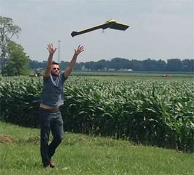
In another UASC project, UASC and The Ohio State University initiated regular flight operations in July at Molly Caren Agricultural Center to research various types of UAS sensors to improve agricultural productivity and enhance environmental management practices through improved nutrient use efficiency.
3D Aerial, a UAS business in Dayton, Ohio, pilots the small 1.5-lb fixed-wing aircraft for this project. Data gathered is part of a research and development effort focused on noninvasive assessment of crop health.
“This data will be analyzed and results will be used in support of research on cropping systems and assessment of environmental factors affecting crop growth,” said Scott Shearer, professor and chair of the Food, Agricultural and Biological Engineering at Ohio State. “In addition to precision agriculture experiments, this research will help enhance water quality by better understanding how best management practices may impact surface and ground water quality.”
The UAS market is projected to be an $82 billion industry with a potential to create approximately 100,000 jobs nationally over the next 10 years.
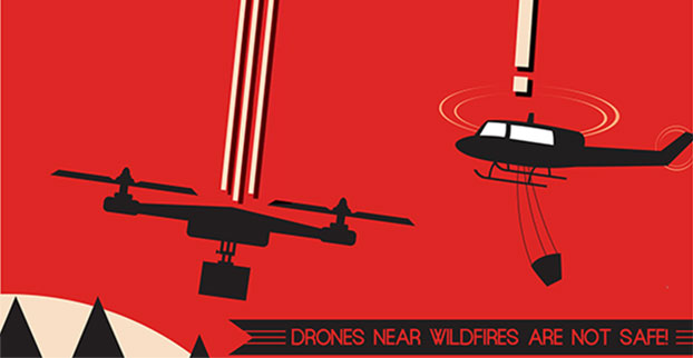
The Federal Aviation Administration (FAA) wants to send out a clear message that operating drones around airplanes and helicopters is dangerous and illegal. Pilot reports of unmanned aircraft have increased dramatically over the past year, from a total of 238 sightings in all of 2014, to more than 650 by Aug. 9 of this year. Unauthorized operators may be subject to stiff fines and criminal charges, including possible jail time.
Pilots of a variety of different types of aircraft — including many large, commercial air carriers — reported spotting 16 unmanned aircraft in June 2014, and 36 the following month. This year, 138 pilots reported seeing drones at altitudes of up to 10,000 feet during the month of June, and another 137 in July.
Meanwhile, firefighters battling wildfire blazes in the western part of the country have been forced to ground their operations on several occasions for safety reasons when they spotted one or more unmanned aircraft in their immediate vicinity.
The FAA says it will continue to work closely with industry partners through the “Know Before You Fly” campaign to educate unmanned aircraft users about where they can operate within the rules. The agency is also supporting the National Interagency Fire Center’s “If You Fly, We Can’t” efforts to help reduce interference with firefighting operations.
However, the FAA also is working closely with the law enforcement community to identify and investigate unauthorized unmanned aircraft operations. The FAA has levied civil penalties for a number of unauthorized flights in various parts of the country, and has dozens of open enforcement cases.
The FAA encourages the public to report unauthorized drone operations to local law enforcement and to help discourage this dangerous, illegal activity.
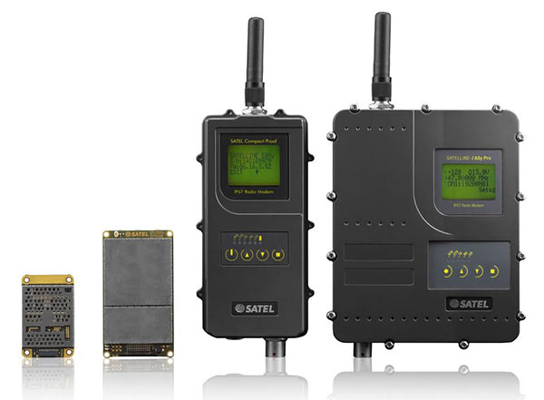
Finnish radio data communication specialist Satel will present innovative new products for mission-critical radio data networks at INTERGEO, being held in Stuttgart, Germany, Sept. 15-17.
In Germany, radio data communication solutions from Satel are distributed by the full-range and systems provider Welotec. At the trade fair in Stuttgart, the partners will present their products at adjacent stands. Both Satel as a radio data communication specialist and Welotec as a full-range and systems provider have a strong portfolio for the core market of RTK/GNSS, UAV and RPAS (remotely piloted aircraft systems) applications.
By 2020, Satel intends to be the world’s number one provider of mission-critical data connections, it said in a statement. This goal also includes becoming the technology leader, which the company hopes to achieve through intensified research and development.
At INTERGEO, Satel will present its latest products. Visitors will be able to see the OEM modules Satelline-M3-TR1 and Satelline-M3-TR4. These modules allow use of the frequencies requiring a license (330 – 473 MHz) as well as the European license-free frequency ranges (433.05 – 434.79 MHz and 869.400 – 869.650 MHz).
The newly developed Satelline-M3-TR4 is the smallest available data transceiver module in its class, according to Satel. The Satel Compact-Proof is a portable radio data modem with a rechargeable battery and a flexible tuning range (403 – 473 MHz). The robust Satelline EASy Pro 25W, likewise with a broad tuning range (403 – 473 MHz), allows radio communication up to a range of 50 km, which makes it quite versatile.
Welotec offers a large range of antennas that supplement the Satel radio data modems. The antennas cover a large frequency range from 68 MHz to 6000 MHz, indoor and outdoor applications, MIMO technology and also antennas with an operating range from minus 40 degrees Celsius to 80 degrees C for use in harsh environments. At INTERGEO, visitors will see innovative solutions from Welotec in the area of industrial communication — for example, the industrial UMTS, LTE and WLAN routers of the TK800 series or the high-performance Industrial-WLAN access point DM500. For measuring tasks, Welotec offers the laser distance sensor OWTB V2.1, which features an extremely high resolution and ranges of up to 500 meters for industrial applications.
Satel and Welotec will be at INTERGEO 2015 in Stuttgart in Hall 4, Booth G4.020. GPS World is covering INTERGEO live — visit gpsworld.com and follow us on Twitter and Facebook.