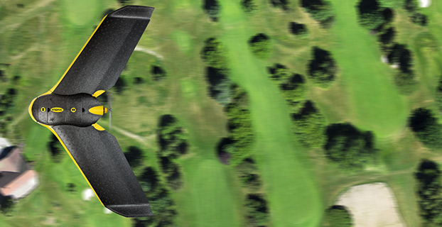
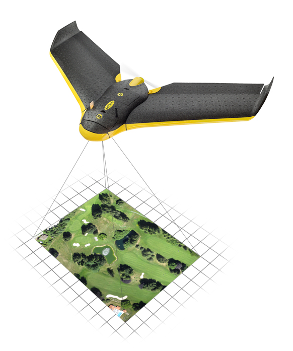
The eBee Sensefly UAV. Photo: Advanced Aviation Solutions
The Federal Aviation Administration (FAA) today granted two more regulatory exemptions for unmanned aircraft systems (UAS) operations for commercial use.
The two companies are Advanced Aviation Solutions of Spokane, Wash., and Tierra Antiqua Reality of Tuscon, Ariz. Advanced Aviation Solutions plans to fly an eBee senseFly UAV Ag system carrying a georeferenced still camera to conduct photogrammetry and crop scouting in order to perform precision agriculture.
The eBee Ag system consists of a 1.5-pound battery-powered aircraft, a personal computer-based ground control station, and associated communications equipment. The UAV is a fixed-wing aircraft with a wingspan of about 3 feet and 2 feet in overall length, which can operate at a maximum speed of about 50 knots.
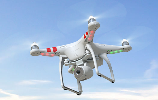
Tierra Antiqua Reality plans to operate a Phantom 2 Vision+ UAS, which is comprised of an unmanned aircraft and a transportable ground station. The company plans to attach a small ultra-6 lightweight GoPro 3+ camera to the Phantom and operate it over various areas near Tucson to enhance academic community awareness and augment real estate listing videos.
The Phantom is a 3-pound quadcopter with a maximum airspeed of 30 knots.
HEXO+, an autonomous flying camera system, by Squadrone Systems will exhibit at CES 2015.
An Unmanned Systems Marketplace debuts this year at the annual International Consumer Electronics Show (CES), being held this week in Las Vegas. The marketplace highlights the burgeoning technology in drones, unmanned aerial vehicles (UAVs), and other unmanned systems controlled by onboard computers or remotely from the ground.
Also, a session on drones will focus on safety and privacy of commercial UAV use.
The Unmanned Systems Marketplace is at CES Tech East, in the Las Vegas Convention and World Trade Center (LVCC), South Hall 2. Tech East includes the LVCC, the Westgate Las Vegas , and Renaissance Las Vegas. Exhibitors at the marketplace include AirDog, Squadrone, Trace, DJI, iRobot, Trace, Torquing Group DBA ZANO, Ecovacs, EHang, Autel, Pelican Products, and other brands.
According to the CES description of the marketplace, “Drones, UAVs and other unmanned systems have taken off as a unique tool for everyday life, regardless of whether flight is controlled by onboard computers or remotely from the ground. Unmanned systems have revolutionized the way we capture, monitor and assist our world. They provide aerial coverage for sports, travel and real estate; enhance search and rescue, law enforcement and disaster relief; and so much more. Experience the variations in design and functionality of this technology with these current exhibitors in the all-new Unmanned Systems Marketplace.”
The session description reads, “The use of unmanned aerial vehicles (a.k.a. drones) for mapping, surveillance, newsgathering, filmmaking, and recreation is on the rise. Drone experts explore commercial and consumer market opportunities — including using drones to deliver packages — and address issues about safety and privacy.”
Record-Breaking Year Ahead: Industry Revenues to Reach All-Time High of $223.2B in 2015
Revenues for the consumer electronics (CE) industry are projected to grow three percent in 2015 and to reach an all-time high of $223.2 billion, according to The U.S. Consumer Electronics Sales and Forecasts, the semi-annual industry report released today by the Consumer Electronics Association (CEA). The total revenues forecast was announced by CEA President and CEO Gary Shapiro during his opening remarks today at the 2015 International CES, running January 6-9 in Las Vegas.
CEA’s consensus forecast reflects U.S. factory sales to dealers and covers more than 100 CE products. The twice-annual report serves as a benchmark for the CE industry, charting the size and growth of underlying categories.
Emerging Technologies
The 2015 forecast projects that revenue for new, emerging product categories is expected to double, growing 108 percent year-over-year in 2015. These new technology categories include unmanned systems (unmanned aerial vehicles, unmanned vehicles and home robots); wearables such as health and fitness devices, smartwatches and smart eyewear; IP cameras; 3D printers; 4K Ultra-High Definition televisions; and connected thermostats.
While the emerging product categories represent less than five percent of the entire CE industry revenue forecast, they are expected to contribute almost $11 billion to overall CE revenue in 2015.
“Our forecast underscores that consumers’ love affair with technology shows no signs of slowing any time soon,” said Shapiro. “Consumer technology is all about continued innovation. In the blink of an eye, consumer demand has taken off for emerging categories such as wearables, unmanned aerial vehicles and 4K Ultra HD — categories that were too small to track just three years ago. Expect to see these burgeoning categories, as well as innovations across the full spectrum of consumer technology, on display this week at the 2015 International CES.”
The Wearable Revolution
The wearable device revolution is a key category to watch in the coming years, and especially in 2015. CEA projects overall wearable unit sales will reach 30.9 million units (a 61 percent increase from last year) and generate $5.1 billion in revenue in 2015 (a 133 percent increase). CEA’s wearables category encompasses fitness activity bands and other health and fitness devices, as well as smartwatches and smart eyewear.
Health and fitness devices: Led by the popularity of activity tracking devices, health and fitness devices will lead unit sales among all wearables in 2015 with a projected 20 million units. Revenue is expected to surpass $1.8 billion in 2015.
Other mobile devices:
Smartphones: As the sales leader of the industry, smartphone unit shipments are projected to reach 169.3 million this year, up six percent from 2014. Additionally, smartphone revenues are expected to generate $51.3 billion in 2015, a five percent increase from last year. Particular growth will be seen in screen sizes between 5.3 inches – 6.5 inches.
Tablets: Unit sales of tablets are projected to reach 80.7 million this year, a three percent increase from 2014. Revenues for tablets will reach $24.9 billion this year, down one percent.
“Mobile connected devices have reached an equilibrium, stabilizing the steep climb these products have experienced in recent years,” said Shawn DuBravac, Ph.D., chief economist, CEA and author of CEA’s soon-to-be released book Digital Destiny: How the New Age of Data Will Transform the Way We Work, Live, and Communicate. “Overall, improving economic conditions, consumer enthusiasm for new features and product categories, competitive manufacturer pricing and several other dynamics now at play should make 2015 an especially significant year for tech.”
Other CE categories expected to enjoy positive growth in 2015 include audio, electronic gaming and laptops. Automotive electronics will see continued growth due to new vehicle sales in 2015, reaching $14 billion in revenue, a 3.3 percent increase.
The U.S. Consumer Electronics Sales and Forecast 2010-2015 (January 2015) is published twice a year, in January and July, reporting U.S. factory sales-to-dealers. It was designed and formulated by CEA to be a comprehensive source of sales data, forecasts, consumer research and historical trends for the consumer electronics industry.
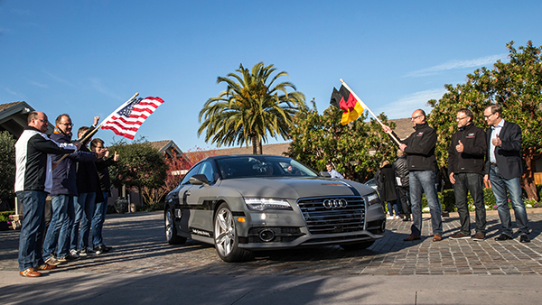
Start of the 550-mile piloted drive from Silicon Valley to Las Vegas: Ricky Hudi, Audi executive vice president electric/electronic development (left) and Ewald Gössmann, excecutive director Electronic Research Lab California (ERL), (third from right) drop the flag for the Audi A7 piloted driving concept car. Photo: Audi
An autonomous Audi A7 is driving itself to Las Vegas for this week’s 2015 Consumer Electronics Show. The Audi is making the 550-mile trip as journalists sit behind the wheel for 100-mile stretches with an Audi official in the passenger’s seat.
The car left Stanford, Calif., Jan. 5 and traversed real-world roads and traffic conditions on its way to Las Vegas.
The long-distance test drive of the Audi A7 piloted driving concept car is designed to show that unprecedented performance can be achieved with series production technology, Audi said in a statement.
“The test drive from the west coast of California to Las Vegas demonstrates our leadership role in piloted driving,” said Prof. Dr. Ulrich Hackenberg, Audi board member and head of technical development. The test drive in real world traffic and road conditions represents a joint effort by the Volkswagen Electronics Research Laboratory (ERL) und Volkswagen Group Research and Development, begins today in Stanford, CA. The Audi A7 piloted driving concept will drive more than 550 miles, approximately 900 kilometers.
The A7 piloted driving concept uses the latest technologically advanced systems developed by Audi. The concept relieves the driver of driving duties from 0 to 70 mph, or just over 110 km/h. The car, named “Jack” by the development team, can initiate lane changes and passing maneuvers. In addition, the A7 piloted driving concept accelerates and brakes independently. Before initiating a lane change to the left or the right, the vehicle adapts its speed to surrounding vehicles. If the speed and distance calculation is deemed safe, the vehicle initiates the lane change with precision and in a timely manner.
The piloted concept vehicle uses a combination of various sensors, many of which are close to production ready. The long range radar sensors of the adaptive cruise control (ACC) and the Audi side assist (ASA) keep watch of the front and rear of the vehicle. Two mid-range radar sensors at the front and rear respectively are aimed to the right and left to complete the 360 degree view. Laser scanners are mounted within the Singleframe grille and the rear bumper skirt. The scanners deliver redundant information to provide detailed recognition of static and dynamic objets during piloted driving. The technologies are production ready including their vehicle integration and cost structure for vehicle production in the near future. A new high-resolution 3D video camera, already integrated into the next-generation systems found in the new Q7, takes a wide-angle view out in front of the vehicle. Four small front and rear mounted cameras view closer surroundings. Navigation data is used for basic vehicle orientation.
Before the piloted driving system reaches its limitations, in city environments for example, the driver is requested to take control of the vehicle to ensure proper safety. Multiple warning signales work in unison: colored LEDs at the base of the windshield, signals in the driver information display, a Central Status Indicator (CSI), as well as a acoustic warning indicator requires the driver to retake control. Should the driver ignore the signals, the system activates the hazard lights and brings the car to a full stop while minimizing any risk. In most instances the vehicle is stopped on the right emergency lane.
The training for the jounalist test drivers taking part in the 550-mile trek took place several weeks ago at the Arizona Proving Grounds. Each journalist will drive approximately 100 miles using the piloted driving system. A trained Audi professional test driver will accompany the media from the passenger seat for added safety.
Macy’s added Shopkick indoor location beacons in preparation for holiday shopping. (Photo by Nicholas Eckhart is licensed under CC BY 2.0.)
This year was filled with hope and some success for the location industry. In what was probably the biggest deal, Qualcomm bought United Kingdom-based CSR for $2.5 billion — at the same time, spinning off its own location beacon company, Gimbal. While the connected car continued to get a lot of press at the biggest trade shows, indoor location technology matured to a point that many retailers are believing it’s a way to get consumers back into the stores — and away from their computers.
As we come to the end of 2014, many industry observers view indoor technology and markets to be like where outdoor location was in the early 1990s: many technologies and providers all pushing different solutions. However, the gap between the beneficiaries of the market, the retailers and brands, and the indoor location technology providers is narrowing as tests become more prevalent.
Such retailers as Walgreens, Home Depot, Lowe’s, Macy’s and CVS have rolled out, or planning to launch, tests that include indoor mapping and a product locator.
“iBeacons and other beacons proved to be the fastest location-proximity technologies that are being deployed full scale by Macy’s, CVS and other retailers for a first quarter 2015 rollout,” said Kris Kolodziej, an indoor location-based services advisor. “I see more acquisitions like the one of Groupon acquiring Swarm Mobile, a beacon platform for smaller tier-two retailers and businesses. In addition, we will see more partnerships like the one between Gimbal and Urban Airship to provide a holistic outdoor-indoor solution for geofencing and engagement platforms.”
Location companies paid attention to mobile carriers’ focus on launching and advancing their LTE services in 2014, said Keith Bhatia, TeleCommunication Systems vice president, business development.
“2014 has been the year of transitioning location-based services from 2G to 3G to complete 2G-3G-4G platforms,” he said. “The other significant location market event for TCS during 2014 has been growth of user plane services by (over-the-top) apps. The operators who have chosen to compete with OTT players have seen location requests exponentially expand.”
TCS believes that the location market, in the next five years, will evolve to a machine-to-machine and Internet of Things (IoT) concepts that will expand into consumers’ everyday lives, Bhatia said. “From the connected car to telemedicine, health devices, connected home and smart cities, all mobile connected devices will benefit from location-based services,” he said. “We believe that location services will continue its rapid growth for years to come.”
Selling retails on the promise of indoor positioning and proximity marketing has been tough in the past few years — and some providers have focused on the wrong message, Bhatia said. “As mobile device adoption continues to surge, indoor positioning and proximity marketing will become an important tool for many retailers. A significant barrier so far has been too much focus on coupon delivery,” he said. “We believe the retailers will find real benefits in terms of understanding layout, traffic and congregation of users. Combining this location information with their retail data will provide early insights into trends and early indications of potential challenges.”
Dave Hutingford, CSR director of product line for location, believes the big selling point for retailers is striking the balance between what benefits they obtain from the app versus what benefits the consumer gets — what he calls the equity balance.
“Too many irrelevant notifications while walking around the shop will result in people not wanting to run the app, and can potentially harm consumer acceptance of retail applications. The interest is already there from the retailers’ side as the benefits are somewhat obvious, but the question is what do you give back to an increasingly technology-smart consumer?” he said.
Overall, the indoor location market is attracting major interest from retailers — which is refreshing to many industry observers after seeing online sales cut into brick-and-mortar stores’ profits.
“Removing the need for dedicated infrastructure to run indoor location was a big hurdle removed from the ecosystem. Certainly we expect to see good pick-up of the solution over the next few months for a wide variety of location services, and being handset-agnostic is a big benefit for any developer,” Hutingford said. “However, if you are looking for accuracy down in the meter range, you will need to add infrastructure to supplement the location calculation, which can come in many forms.”
Connected-Car Market Made Headlines in 2014
If an industry executive attended any of the bigger trade shows this year — CES, CTIA in Las Vegas, or the Mobile World Congress in Spain, it was the same thing — connected vehicles are the big story. Adoption by automotive manufacturers, as a number of analysts have pointed out this year, was the most important news story for the connected-car industry in 2014, said John Horn, Kore Telematics executive vice president and chief strategy officer.
“Essentially every vehicle that rolls off the assembly line in 2015 will have an element of connectivity built into it. To keep up with the level of demand, we are starting to see scale and scope really start to matter to the companies that power this type of connectivity,” he said. “2015 will prove to be another huge year for industry consolidation, which will be necessary to keep up with the global demand for connected-car technologies.”
The biggest trend in 2014 connected-car technology was the emergence of infotainment content for connected cars, said Scott Frank, Airbiquity vice president, marketing. “Before 2014, the most an average consumer would expect out of a high-end vehicle head unit were features like navigation, basic cell-phone connectivity, and hands-free calling,” he said. “Today, drivers are able to get a wide-variety of apps in their vehicles to do things like stream music and keep up with their social media channels. User experience advancements were also made to provide a seamless transition for digitally oriented drivers as they moved from office, to car, to home, and back again. For example, with the NissanConnect Mobile Apps system, someone listening to a streaming music app like Pandora on their PC in the office can put it on hold, get into their car for the drive home, and pick up the song right where they left off — as well as see their favorite playlists, album selections, and cover art.”
However, as with any industry that experiences quick growth, there will be growing pains, Horn said. “The automotive world has already started to experience some of those pains as connected technologies continue to advance at a rapid pace. We saw how the analog shutdown left many OnStar customers stranded with obsolete hardware,” he said. “We’ll likely see similarities as 2G, 3G, and 4G networks are eventually turned down in favor of more advanced technologies. I’ve been saying this for years, but now is really the time for the removable module. Connected technologies will turn over much faster than cars, and the only way I can see to future-proof against this is through the removable module.”
Airbiquity’s Frank said that there are definitely consumer acceptance and technology barriers for the automotive industry going forward related to connected car as we know it today and autonomous car as its being forecast going forward.
Like waves of technology that have come before, functional consumer awareness and adoption will follow the technology adoption curve, Frank said. “Certain generations and user types will be early adopters and more likely to accept new and evolving connected-car technology and features — and the user experiences and value that come with it — the minute it’s made available,” he said. “While others will be either blissfully unaware of the technology built into their car — and the value it could bring them — or are simply satisfied with traditional technology like basic AM-FM and satellite radio. One thing for sure is there’s a correlation between early adopters of technology like smartphones and early adopters of connected-car technology and related features.”
Frank quoted a recent Parks Associates study that found 48 percent of vehicle owners that own smartphones are very interested in the ability to view maps — or receive directions in their cars. This compares to 37 percent of vehicle owners that own/don’t own smartphones. “Like flip-phone users that transitioned to smartphones after understanding the end benefits, consumers will increasingly become aware of and use their connected-car systems,” he said. “We’re seeing evidence of the connected-car adoption curve in the increasing activation rates and time of usage for our customer’s connected-car programs.”
Horn, who headed RacoWireless, which was acquired by Kore for an undisclosed amount this year, said in 2015 industry will start to see the connected car become much more easily monetized. “We’ve seen this first hand, as we have just rolled out some new features with AT&T and Audi. Now, your Audi Connect subscription can be part of your AT&T Mobile Share plan and treated just like another line,” he said. “It is going to be easier than ever to consume in-vehicle connectivity and the business model will advance to the point that makes it appealing for both the consumer and the solution provider.”
In 2015, driving-centric apps and services will begin to appear and eventually become as important as infotainment content in the consumer purchasing process, Frank said. “The current automotive manufacturers’ focus on providing infotainment delivery reflects their desire to meet the expectations of digital lifestyle consumers who are heavy users of smartphones and want to use their favorite apps and services inside their cars,” he said. “This is a logical first step, but these savvy consumers will increasingly value apps that are truly useful and relative to the driving experience. An example is an app that proactively and dynamically recommends modifications to a driver’s high-frequency routes to help them optimize fuel consumption, lower CO2 emissions, minimize engine wear, and avoid road hazards. As a result, apps that don’t add to the consumer experience relative to driving will eventually die off from lack of use, and automotive manufacturers will replace them with more and more driving-centric apps to satisfy their customers and differentiate themselves from competitors.”
The rise of autonomous vehicles, a derivative from connected-car technology, will keep automakers, carriers, suppliers and government agencies busy for decades.
“When it comes to autonomous vehicles, we expect the adoption curve to be more extended than what we’ll see for the connected car, given the increased consumer concerns about safety and adapting to the new fangled idea of riding in a car without a human driver,” Frank said. “Consumers will not only want to know what this fancy new technology is and how it works, they will also need to feel confident that it will run perfectly and not put themselves, their passengers, or other people and property in harm’s way. Consumers will also have concerns about who will be legally and financially liable if an accident occurs.”
In other location news:
Two Trimble companies, PeopleNet and ALK, recently provided real-time tracking of the 2014 Capitol Christmas Tree’s cross-country journey from the Chippewa National Forest in Minnesota to the front lawn of the U.S. Capitol Building in Washington. The companies used enterprise products for routing, mileage, mapping and visualization to track the tree.
LBS Insider’s Kevin Dennehy will be attending the 2015 Consumer Electronics Show in Las Vegas next month. Please contact him at [email protected] with your story ideas.
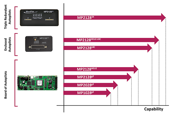
Who is MicroPilot? For almost anyone in unmanned aerial vehicle (UAV) electronics — or, rather, avionics — MicroPilot is probably a familiar name. The company makes the autopilots that basically fly the vehicle. An autopilot is the business-end of the navigation guidance system on a UAV. It takes input from sensors — typically GPS, air data, and inertial/gyro, which can be internal or external to the autopilot — and provides signals that adjust the flight controls to null out errors between the planned flight track and the actual flight profile that the UAV is flying.
A typical UAV autopilot uses GPS/inertial/air data to generate position information for route and waypoint navigation as well as hold modes where altitude and heading are maintained. In addition, it will accept commands from a remote ground-control station to modify the waypoints and route, to go to a specific waypoint, or to land, circle or fly a particular pattern. Telemetry data is also sent to the ground station to monitor status and flight progress. The autopilot acts as a central point within the UAV, communicating to and controlling onboard equipment such as pan-tilt cameras and transponders. The autopilot is also responsible for handling a variety of error conditions, such as loss of communication link or GPS.
MicroPilot was started 20 years ago by Howard Loewen, who is the sole owner and CEO. A licensed pilot, Loewen decided to make a model plane fly all by itself. With a bunch of aero textbooks, a couple of model airplanes, a single-board computer, gyros and a GPS receiver, he basically taught himself how aircraft fly and how to model (simulate) an aircraft. He developed autopilot software and a basic six-degree-of-freedom (DOF) simulator. Linking the simulator software to the autopilot software, he could test fly the autopilot on his PC. This same architecture is still in use at MicroPilot today and enables much more efficient development and testing of autopilot systems.
After many thousands of hours of simulated flight, actual flight testing was, at first, quite difficult for him to master. However, he gained lots of experience during a successful flight test campaign. Then Loewen put together a web page describing what he was doing. Not too long after the web page went live, the phone began to ring, and not long after the phone calls started, orders began to come in. MicroPilot wasn’t the only company selling autopilots at that time, but it may be the only one from that time that is still around.
The company staff jointly decided that they should focus on the high-end commercial UAV market, so there had to be significant investment in production and development processes. Early on, an automated sensor calibration system was developed, which has recently been upgraded to use a two-axis rotating temperature chamber. This system allows MicroPilot to load up a couple dozen autopilots, and a few hours later fully calibrated and tested autopilots emerge! So, peak demand is readily accommodated, and MicroPilot staff is able to focus on product and process improvement rather than on labor-intensive manual testing.
The professional market is a more challenging customer base because customers fly much more expensive vehicles. While there is currently a lot of focus on low-cost hobby autopilots, these are seen as an interim step until there are proper regulations. In the end, UAVs are aviation products, and for many applications they require a high level of reliability and availability. No one is going to be flying 55-pound helicopters over a city without an autopilot that has undergone vigorous validation and verification processes. MicroPilot autopilots have a large number of options that enable configuration of the control system for the type of vehicle — for instance, fixed wing, multi-rotor, helicopter, or aerostat/blimp. Once the type of vehicle has been selected, the gains of the various feedback loops that control the vehicle are configured. There are also quite a few options for payloads and other onboard devices such as transponders and cameras.
MicroPilot is based in Winnipeg, Manitoba, Canada. The city is large enough to have a pool of talented engineering and computer science graduates. While the winter climate can be quite harsh, the city is not so large that there is much trouble finding a place to test fly. The MicroPilot facilities are about six miles outside the city, and the staff is able to test fly right outside their building under a Transport Canada special flight operations certificate. MicroPilot has 27 employees, ships in the order of 1,000 autopilots per year, and has 850 customers in 70 countries.
Regulation is the key to moving the commercial UAV market forward — a huge market is already flying sophisticated, expensive sensor payloads over cities. Even a moderate-size Multirotor UAV poses some safety risks, and it is important that regulators quickly devise rules to allow safe flight of these sensors over populated areas. MicroPilot has been working on improving its product offerings so that when regulations finally appear, the company will have products with the right capability and implemented correctly, so regulators should be able to readily establish that its products are safe. To this end, the first triple-redundant autopilot was introduced four or five years ago. It is still the only triple-redundant UAV autopilot available. Triple redundancy implies that two out of three channels could totally fail, and no failure will carry over from one channel to another, so autopilot functionality for the vehicle would still be maintained.
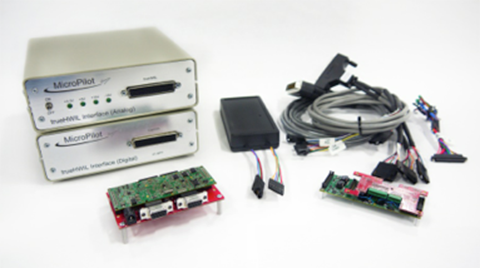
trueHWIL is a high-fidelity simulator that MicroPilot has developed where the sensors are stripped from the autopilot and the sensor inputs are simulated electrically. The simulator also reads control-position information from the autopilot. Under this simulator, the autopilot receives sensor data as if it is in the air. The code paths that the autopilot software executes are identical to those in a real autopilot in flight. Customers use this tool to build “iron-bird” simulations of the vehicle on the ground to validate the configuration prior to flight. It enables week-long or longer instrumented flight tests to be performed that would be difficult or dangerous to perform in real life.
trueHWIL high fidelity simulator. Photo: Micropilot
Finally, the xtender validate product has been developed. This requirements capture system allows customers to link system requirements to autopilot or ground control system (GCS) settings. It also allows the system designers to develop electronic flight-test cards linked to requirements. After flight test, the resulting data logs can be linked back into the xtender validate database and will also be automatically linked to the requirements used to define the flight-test card. This simplifies the flight-test process and allows managers to see that the system requirements have been completely exercised by flight testing.
MicroPilot integrates a number of different GPS receivers into its autopilots, including Trimble, u-blox and Novatel.
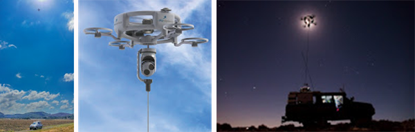
Sky Sapience in Israel has developed a unique HoverMast-100 solution for short-range, over-the-horizon reconnaissance. This UAV on a tether requires a high level of stabilization, which the MicroPilot autopilot enables. The tether allows for deployment up to a height of 50 meters within seconds, and the UAV can carry a 13-pound payload for a video camera, IR sensor, laser rangefinder, RF relay or other sensor — real-time data is transmitted to users over a wideband radio link. Armed forces in the United States, Israel and Asia are using the HoverMast-100. Commercial applications include power-line inspection, oil and gas pipelines, security, perimeter security, oil rigs, boats, agriculture, communication, sports events and disaster relief.
MicroPilot’s customer base is worldwide, with almost 1,000 different organizations having dealt with the company over the years. The range of applications goes from researchers flying a very odd vehicle with the ailerons split into a dozen segments (each controlled separately) all the way to customers using the system for traditional intelligence, surveillance, and reconnaissance (ISR), such as Bluebird Aero Systems. There are also customers that make multi-rotors (the proS3 in Italy) for a variety of data-collection needs; customers that fly targets (Avartek of Finland); customers that fly helicopters for video filming and emergency responders (Bertin in France and Helicam Pro in Italy); and customers that use UAVs in aerostats (Top I Vision in Israel). There are also a bunch of universities doing research using UAVs, and a couple of customers flying turbine powered UAVs.
So, for a significant number of UAV manufacturers and operators spread around the world, MicroPilot has become the supplier they rely on for autopilot solutions. And with the FAA now issuing what seems to be daily exemptions that allow commercial use of UAVs, it’s good to know that at least one autopilot supplier is already working towards the reliability and availability that certified applications of these vehicles will ultimately require.
The Federal Aviation Administration (FAA) today granted five regulatory exemptions for unmanned aircraft systems (UAS) operations to four companies representing several industries that promise to benefit from UAS technology, including Trimble Navigation Ltd.
The four companies that received exemptions want to fly UAS to perform operations for aerial surveying, construction site monitoring and oil rig flare stack inspections.
“Unmanned aircraft offer a tremendous opportunity to spur innovation and economic activity by enabling many businesses to develop better products and services for their customers and the American public,” Transportation Secretary Anthony Foxx said. “We want to foster commercial uses of this exciting technology while taking a responsible approach to the safety of America’s airspace.”
The commercial entities that received exemptions today are Trimble Navigation, VDOS Global, Clayco, and Woolpert (two exemptions). The FAA earlier granted exemptions to seven film and video production companies. This is the first exemption granted to a leading GNSS firm.
Secretary Foxx found that the UAS in the proposed operations do not need an FAA-issued certificate of airworthiness because they do not pose a threat to national airspace users or national security. Those findings are permitted under Section 333 of the FAA Modernization and Reform Act of 2012.
The firms also asked the FAA to grant exemptions from regulations that address general flight rules, pilot certificate requirements, manuals, maintenance and equipment mandates. In their petitions, the firms said they will operate UAS weighing less than 55 pounds and keep the UAS within line of sight at all times.
The exemption will allow Trimble to conduct commercial operation of its UX5 Aerial Imaging Solution. The UX5 is an unmanned fixed-wing aircraft targeted at the surveying, agriculture, oil and gas, mining, construction, environmental industries. The system autonomously captures a series of high-resolution images during flight, which is typically up to 50 minutes covering as much as 2.3 square kilometers (approximately 1 square mile) when flying 120 meters (approximately 400 feet) above the ground. Using Trimble Business Center Aerial Photogrammetry software, images are used to easily generate 2D and 3D deliverables such as orthomosaic images, three-dimensional point clouds and contour maps. The Trimble UX5 enables the collection of large amounts of data, often faster than traditional surveying or mapping technologies.
The Trimble UX5 surveys a construction site. Photo: Trimble
“We are pleased to be among the first companies to receive an exemption from the FAA authorizing commercial operation of UAS,” said Erik Arvesen, vice president of Trimble’s Geospatial Division. “This decision reflects Trimble’s efforts to responsibly operate its UAS business in the U.S. while the FAA addresses air safety issues in opening the NAS for commercial UAS operations on a broader scale. Trimble will continue its efforts to support the FAA’s decision-making process and to provide opportunities for our customers to safely use the UX5 to capture accurate geospatial data for a wide range of applications such as surveying, oil and gas, mining, construction and many more.”
“In the agriculture market, the FAA exemption moves Trimble one step further with the opportunity to provide a solution for safe and legal UAS operations that can benefit growers, ranchers, water management contractors, agronomists and other ag service providers,” said Joe Denniston, vice president of Trimble’s Agriculture Division. “High-speed aerial imaging is a powerful tool that can quickly and easily capture aerial images for scouting and monitoring crop health, locating cattle and their available forage over large areas, measuring crop height, and generating topographic maps and models for land leveling and drainage applications. As a result, the system can be a powerful data collection tool that can aid with recommendations to improve farming operations.”
In granting the exemptions, the FAA considered the operating environments and required certain conditions and limitations to assure the safe operation of these UAS in the National Airspace System. The agency also will issue Certificates of Waiver or Authorization (COAs) that mandate flight rules and timely reports of any accident or incidents..
“The FAA’s first priority is the safety of our nation’s aviation system,” said FAA Administrator Michael Huerta. “Today’s exemptions are a step toward integrating UAS operations safely.”
As of today, the agency has received 167 requests for exemptions from commercial entities.
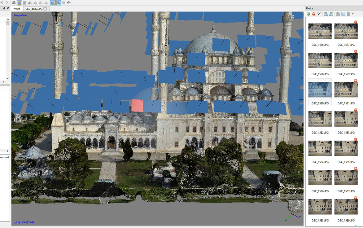
The Sabancı Merkez Mosque in Adana, Turkey, has been inspected and mapped by an unmanned aircraft system and a detailed 3D model created. The work was carried out by SISTEM A.S. (the Turkish distributor of Leica Geosystems), NRJ Engineering and Aibotix.
Sabancı Merkez Mosque is the largest in Turkey, with six minarets, four of which are 99 meters high. The largest of its five domes is 32 meters in diameter and 54 meters high, so determining the actual state of the building using conventional methods would be time consuming and costly. Instead, the authorities commissioned a UAV inspection.
“We needed only three flights to cover all relevant areas and generate comprehensive data,” said SISTEM A.S. employee Bora Yavuz, who has been working with terrestrial laser scanning systems for the past five years. “Compared to laser scanning, collecting the data from the top sections of this huge building by UAV was extremely easy, since nobody had to climb up to the minarets or dangerous places on the domes and wait for the machine to scan. Furthermore, alongside the data registration the generation of point clouds runs automatically.”
During the flight over the roof of the mosque, the UAV followed a defined route that had been planned on the computer beforehand. The pilot then steered the UAV manually in two more flights around the building.
The Aibot X6 was carrying a Nikon Coolpix A digital camera and created high-resolution photos with an 80 percent overlap. Using live images from the UAV’s perspective that were sent directly to the screen of a ground station, the pilot could make sure that all relevant areas were captured, and achieve the best possible results by adjusting the camera to the optimum angle during the flight.
The data was subsequently processed to create an accurate 3D model of the mosque with a precision down to 1-2 centimeters. The high-resolution photos are linked to the model so that damage can be located accurately, with GPS information synchronized with the images for fast post-processing. The images and the model will now be used as the basis for maintenance and repairs.
What flies, takes selfies and fits in the palm of your hand? The tiny Zano drone.
Zano is a portable aerial photography and video platform designed for consumers that measures 65 x 65 millimeters and weighs 55 grams. Torquing Group, who is developing Zano with the help of a successful Kickstarter campaign, said that Zano’s ability to fly autonomously will provide new possibilities for users seeking to capture images and videos. The drones can even be programmed to swarm.
Zano’s location capabilities are powered by OriginGPS’ Nano Hornet, a tiny GPS module with an integrated antenna. Measuring just 10 x 10 x 3.44 millimeters, the Nano Hornet delivers performance and sensitivity with low power consumption. It achieves a rapid time to first fix of less than one second, with approximately one meter accuracy and -163 dBm tracking sensitivity. Because it detects changes in context, temperature, and satellite signals, it achieves a state of near continuous availability, while consuming mere microwatts of battery power.
The Zano connects directly with smart devices (iOS or Android) via onboard Wi-Fi to upload and share images or videos instantly. With the help of OriginGPS, Zano is able to know exactly where it is in relation to a smart device, even when powered off. Through a virtual tether, Zano will echo any movement made by the smart device it is synced to, with simple gesture control. A user will be able to control multiple Zanos from one device, enabling photographs and video of the same event from multiple vantage points.
Zano is also able to function in a “free flight” mode, which uses on-screen joysticks for an experience similar to a regular RC-operated UAV. OriginGPS’ location capabilities allow Zano to know if it is getting too far from its corresponding smart device and automatically return. Likewise, it is able to recognize its distance from the smart device and maintain that distance in “follow me” mode.
Since 2008, Torquing Group has developed small unmanned aerial vehicles (UAVs) for the military and defense industry.
To further push the boundaries of GPS modules designed to be small, agile and light weight, OriginGPS introduced the Nano Spiderintegrated GPS receiver in November. The Nano Spider module is designed to support ultra-compact applications where size is at a premium, such as smart watches, wearable devices, trackers and digital cameras. Like the Nano Hornet, it packs a wide range of functionality into its small form factor, including dual-stage LNA, RF LDO, SAW filter, TCXO, RTC crystal and RF shield with market-leading SiRFstarIV GPS SoC.
Amazon.com is warning the Federal Aviation Administration (FAA) that it will move its drone research abroad if it doesn’t get permission soon to test-fly in the United States, reports TheWall Street Journal. Amazon has already begun researching drone flights in the United Kingdom.
“Without the ability to test outdoors in the United States soon, we will have no choice but to divert even more of our [drone] research and development resources abroad,” wrote Amazon’s vice president of global public policy Paul Misener in a letter to the FAA, according to The Wall Street Journal. “I fear the FAA may be questioning the fundamental benefits of keeping [drone] technology innovation in the United States,” Misener wrote.
The FAA is required by U.S. Congress to frame a “safe integration” plan for the commercial use of UAS by Sept. 30, 2015. Changes in the law could restrict users of commercial UAVs by requiring licenses, with licenses issued to users only after many hours in the cockpit of a manned aircraft, comparable to traditional pilot licenses. The new rules would also limit flights to under 400 feet and within sight of the person at the controls, which is the current rule for hobbyists.
One of the FAA’s concerns is conflicts with manned aircraft. FAA data shows dozens of dangerous encounters around the country over the past six months, according to the Washington Post. Since June 1, commercial airlines, private pilots and air-traffic controllers have alerted the FAA to 25 episodes in which small drones came within a few seconds or a few feet of crashing into much larger aircraft. Many of the close calls occurred during takeoffs and landings at the nation’s busiest airports, presenting a new threat to aviation safety after decades of steady improvement in air travel.
Read one blogger’s account of a close call using a drone, partly caused by loss of the GPS signal.
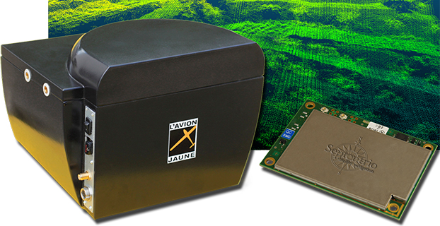
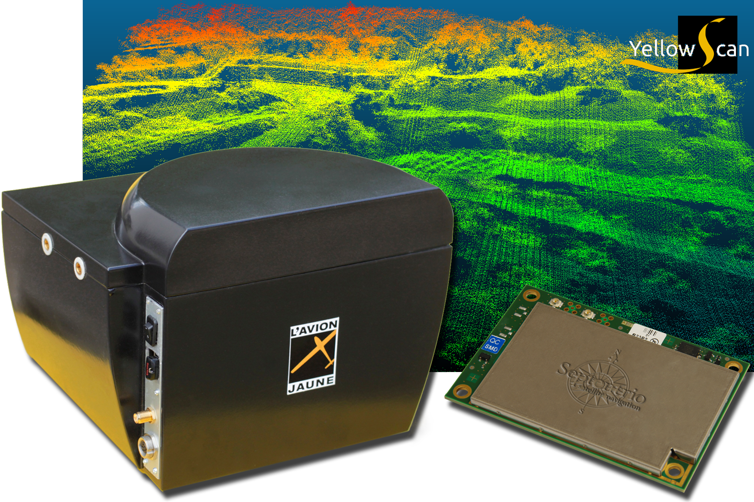
L’Avion Jaune, a service provider and airborne sensors integrator in the field of aerial surveys, has selected the Septentrio AsteRx-m to equip its YellowScan unmanned aerial system. L’Avion Jaune chose the AsteRx-m for its robustness and low-power consumption, Septentrio said.
YellowScan is the a lightweight all-in-one solution designed to deliver quality aerial surveys carried out using a LiDAR sensor aboard UAVs. The self-contained system integrates into a small package all the necessary equipment for conducting airborne surveys: a 3D laser scanner, an AHRS, a controller, an autonomous power supply module and the AsteRx-m, a high-performance precision GNSS receiver.
The AsteRx-m provides a compact and low-power solution for precise positioning in difficult environments where the tracking of both GLONASS and GPS satellites allows the receiver to improve the availability and robustness of a positioning solution. Septentrio’s newest RTK models optimally adapt to situations where GNSS signals can be distorted by reflective surfaces and feature unique countermeasures to disturbances, maintaining accurate and stable measurements wherever and whenever centimeter-level accuracy is needed, the company said.
“The easy-to-integrate AsteRx-m has proven to deliver the most reliable and stable RTK performance of all, in a compact and exceptionally low-power consumption module,” said Michel Assenbaum, CEO of L’Avion Jaune. “The AsteRx-m allows us to extend the operational range and capabilities of the YellowScan, a fully autonomous surveying solution dedicated to UAVs. We have tested the solution in various environments across the world and have never seen it falter.”
“We are delighted that L’Avion Jaune, a respected expert in designing unmanned-aerial remote sensing solutions, has validated the excellent performance of our ultra-compact GNSS receiver,” said Jan Van Hees, head of business development at Septentrio. “We are impressed to see how much interest YellowScan has drawn since its introduction and we are very proud to be contributing to the success of a best of breed solution in this highly competitive market.”
SPAR Point Group will hold its first Commercial UAV Expo, October 5-7, 2015, at Caesars Palace in Las Vegas, Nevada. The event will feature an exhibit hall of UAV manufacturers, component and sensor manufacturers, software providers and service companies.
Organizers expect upwards of 1,000 attendees and 80 exhibits in 2015. Las Vegas was selected for proximity to key players on the West Coast and an affordable and accessible location for the entire market. A two-day conference program will feature programming tracks including commercial applications, hardware and software options, cost considerations, the regulatory environment and data management and integration.
SPAR Point Group are organizers of 3D technology events in North America, Europe and Asia. “We have been listening to our customers and watching the market for some time,” said Lisa Murray, director. “While it is well known that the unmanned aerial vehicle is a game-changing technology, the regulatory environment and concerns over safety have kept commercial growth to a minimum. Given the potential benefits of approved commercial UAV use and global market projections of $12 billion for commercial UAVs over the next decade, the time is right to launch this event.”
“Moving forward, it is vital that the industry has an event dedicated to commercial UAV use,” saidDave Henderson, Topcon’s director of geospatial sales. “SPAR Point Group is uniquely qualified to host such an event given their history and expertise delivering top-notch business and technology events for 3D precision measurement and imaging. They already have established relationships with providers and potential users in key market sectors eager to integrate UAV systems.”
“We are excited to connect the UAV community with potential customers in surveying and mapping, civil infrastructure, mining, construction, process, power and utilities, precision agriculture, law enforcement, security and emergency response,” Murray said. “These are natural markets for commercial UAVs, and ones in which we have established contacts. Seasoned professionals in aerial, mobile and terrestrial data capture technology are particularly interested in the business benefits UAVs provide, including potential cost savings, ease of use, immediacy of data delivery and increased accessibility.”
“In speaking with providers in the UAV sector, it is clear an event focused on industries suited to small UAVs is needed,” Murray said. “While the overall UAV sector is currently dominated by defense and military applications, it is hard to imagine any industry that will not be affected by UAV adoption. Our customers rely on our technology events to deliver the latest innovations on the market. They want to see what’s new and what’s next. Clearly, what’s next is the UAV, and we are excited to showcase this next wave of innovation at Commercial UAV Expo next year.”