Tag: autonomous vehicles

  • LidarSwiss deploys Cepton lidar, Applanix IMU/GNSS for high-fidelity mapping

    LidarSwiss deploys Cepton lidar, Applanix IMU/GNSS for high-fidelity mapping

    Cepton Inc. is working with LidarSwiss Solutions GmbH to deploy its lidar technology in a drone-based mapping and analytics solution for infrastructure management and engineering design applications.

    Cepton is a Silicon Valley innovator of high-performance lidar solutions. LidarSwiss is a Switzerland-based provider of high-performance unmanned aerial vehicle (UAV) lidar solutions.

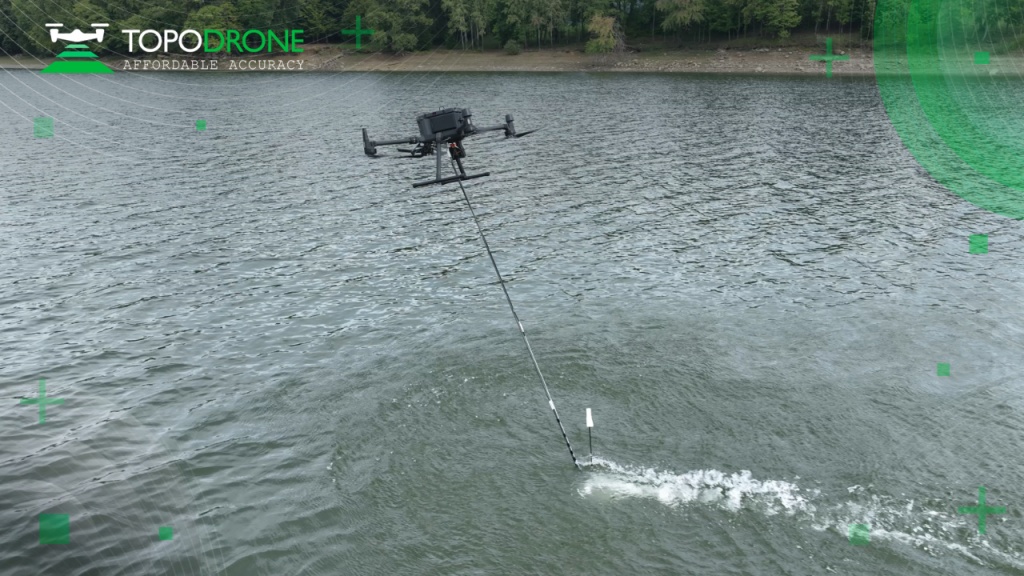
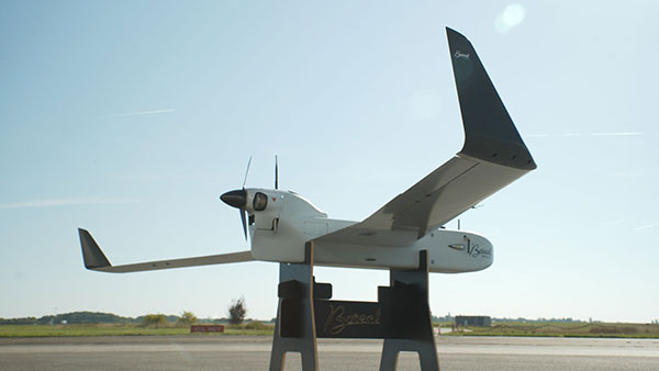
    Utilizing Cepton’s Sora lidar sensor, the LidarSwiss Nano P60 system provides high-fidelity mapping and real-time processing on the fly to serve engineers, forestry managers and urban planners across the globe. To date, Nano P60 has been used to map and analyze powerlines, areas for site development, flood plains and highways in more than 20 cities in Asia, Europe and Australia.

    Nano P60 packages Cepton’s Sora lidar, a 42-mp camera, an Applanix IMU/GNSS and a LidarSwiss controller. (Photo: LidarSwiss)
    Nano P60 packages Cepton’s Sora lidar, a 42-mp camera, an Applanix IMU/GNSS and a LidarSwiss controller. (Photo: LidarSwiss)

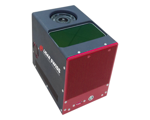
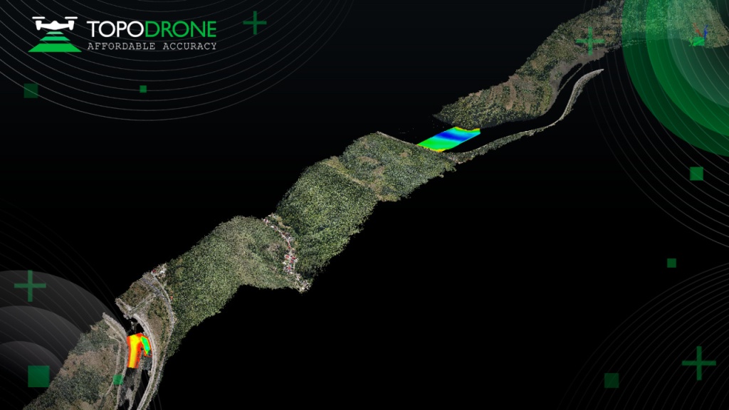
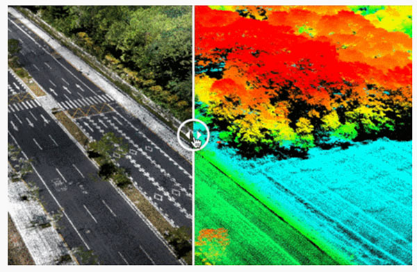
    Nano P60 integrates Cepton’s Sora sensor with a high-precision IMU/GNSS unit from Applanix and high-resolution camera system. Its intelligent controller with LidarSwiss proprietary software automatically combines all raw data to generate high-density, high-precision RGB attributed 3D laser point clouds during flight.

    With a total weight of 2.1 kg, this compact system can be mounted on small UAVs to produce mapping products such as digital orthophotos, digital elevation models and 3D models, or to interface with a third-party software to enable easy, seamless solutions for all kinds of industry applications, such as digital twins, smart cities and building information modeling (BIM).

    “The prominent features of the Nano P60 are its high stability, point density and intelligence,” said Robert Kletzli, LidarSwiss founder and CTO. “This lidar-enabled system addresses the critical gap of 3D accuracy with traditional camera and stereo imaging technologies. Now, instead of needing two images to see a single point and detect its elevation, Nano P60 utilizes lidar’s intrinsic 3D imaging capabilities to achieve maximized efficiency, making real-time processing and analytics possible. Cepton’s Sora lidar is among the most compact, lightweight lidar sensors that we have tested and offers an unparalleled combination of high resolution, longer range in the same category and cost efficiency. Its unique lidar architecture allows seamless integration, making Nano P60 a true plug-and-play system with solid-state reliability.”

    Nano P60 combines lidar point clouds with RGB imagery to generate high-density, high-precision 3D imaging with color by elevation features. (Image: LidarSwiss)
    Nano P60 combines lidar point clouds with RGB imagery to generate high-density, high-precision 3D imaging with color by elevation features. (Image: LidarSwiss)

    “We are proud to be supporting LidarSwiss and its customers with our lidar technology to unlock applications such as 3D modeling for BIM, historical site mapping, terrain modeling for heavy vegetation areas, volumetric calculations for mining, power line inspection and forestry mapping,” said Klaus Wagner, director of Product Management and Marketing at Cepton. “Our Sora lidar is a one-of-a-kind line scanner that combines high frame rate and long range. Powered by Cepton’s proprietary lidar technologies, it is compact, lightweight and rotation-free, making it ideal for small UAV applications.”

  • Atmos appoints Volatus Aerospace as official distributor in Canada

    Atmos appoints Volatus Aerospace as official distributor in Canada

    Photo: Atmos
    Photo: Atmos

    Atmos, a Dutch UAV manufacturer that develops high-end VTOL fixed-wing UAVs for mapping and surveying applications, expanded its global reseller network by signing a reseller agreement with Volatus Aerospace, a leader in commercial drones and UAV technology, in Canada.

    Volatus will be responsible for the distribution of Marlyn Cobalt UAVs in Canada and will provide assistance and maintenance services to local UAV operators. The company brings extensive experience in aviation operations, safety, compliance and innovation to the evolving uncrewed aircraft market.

    Marlyn Cobalt is the first fully autonomous hybrid (VTOL and fixed-wing) drone for mapping and surveying applications. With its patented design that combines the best of both worlds, Marlyn can take off vertically from anywhere and map fast and efficiently producing high-quality outputs for professional users. It is the only drone in its class that is built to perform even in harsh and windy conditions, while its easily swappable payloads provide operators with flexibility.

    “We have an incredible team pushing the envelope on the entire spectrum of UAV technology,” said Glen Lynch, CEO at Volatus Aerospace. “The Marlyn Cobalt survey drone is an exciting new addition to our product offerings.”

  • UAV Navigation defines operational envelope for VECTOR-600 autopilot

    UAV Navigation defines operational envelope for VECTOR-600 autopilot

    An independent study conducted by UAV Navigation has defined the operational envelope of the VECTOR-600 autopilot based on the Specific Operations Risk Assessment (SORA) methodology. The operational envelope defines the operational risk profile within which an aircraft can operate safely, taking into consideration all risk mitigations included within the system.

    The SORA methodology evaluates the safety risks involved with the operation of an unmanned aerial system (UAS) of any class, size or type of operation. The concept of operation (ConOps) is normally used as the input for this analysis; the output takes the form of the Specific Assurance and Integrity Level (SAIL) for a particular operation, which indicates the level of robustness that must be demonstrated for the operational safety objectives.

    In this case, instead of performing a conventional SORA analysis from the ConOps to the SAIL output, this study was performed the other way around because the objective of the study was to identify the operational envelope of the sytem.

    EUROCAE ED-280, the guidelines for UAS safety and analysis for specific categories of low and medium levels of robustness, recommends to any operator a detailed definition of different mission and platform points: the ConOps, the entire UAS architecture including functions, systems, and implementation, identification and classification of failure conditions; verification that safety objectives are fulfilled and a complete probable failure analysis using FMEA-like techniques and Fault Tree Analysis (FTA).

    UAV Navigation prepared an FMECA and FTA analysis performed by a third-party and independent company on the VECTOR-600 autopilot and its onboard sensor suite, the POLAR-300. The study concluded that within the operational envelope of the VECTOR-600, any failure – however remote the probability – is highly unlikely to result in a catastrophic outcome, such as the loss of the aircraft. The conclusions reached indicate that the system is perfectly suited for VLOS/BVLOS operations – including appropriate restrictions where applicable. The system has proved its robustness and suitability for safe operations over a wide range of missions usually performed by professional UAS.

    The analysis is available on request to all clients interested. Contact UAV Navigation for more information.

    Photo: UAV Navigation
    Photo: UAV Navigation
  • TOPODRONE introduces bathymetric surveying device

    TOPODRONE introduces bathymetric surveying device

    TOPODRONE, a Swiss-based designer and manufacturer of high-precision lidar equipment for installation on drones, vehicles and backpacks, launched AQUAMAPPER, a UAV-based solution for bathymetric surveying and marine construction.

    AQUAMAPPER contributes to a complete set of photogrammetry, lidar and bathymetry surveying solutions from TOPODRONE. The product, compatible with the DJI Matrice 300 RTK, provides a combination of high-speed efficiency (up to 14 km/h) and accuracy mounted on a UAV. The application areas include an open sea bathymetric survey up to 100m depth, quantity survey and calculation of sediments and periodic maintenance survey of storage pools.

    Photo: Topodrone
    Photo: TOPODRONE

    The new data-collecting device has been successfully used alongside TOPODRONE’s LiDAR ULTRA equipment for airborne surveying at a highway construction project in one of the toughest terrains in Romania, EU, including 7 tunnels, 24 bridges and 18 viaducts. The project was performed by the Romanian company GRAPHEIN TOPO SA to deliver a full digital twin of a studied area.

    Photo: Topodrone
    Photo: TOPODRONE

    The TOPODRONE LiDAR ULTRA on board a DJI M300 drone was used to capture laser scanning data from an altitude of 100 m to 120 m over rugged terrain forest area to cover a corridor 32 km long and 400 meters wide in 14 flights while AQUAMAPPER connected to the same DJI M300 drone performed a bathymetric survey over six river crossings.

    “The key advantage of the new bathymetric equipment from TOPODRONE is the ability to capture a riverbed with centimeter-level accuracy with high speed in fully automatic mode and without using any boat,” said Andrei Sueran of GRAPHIEN TOPO SA. “The combination of an echosounder, GNSS and inertial measurement system helps to get accurate results after data post-processing.”

  • Estonia confiscates drones for Russia, sends them to Ukraine

    Estonia confiscates drones for Russia, sends them to Ukraine

    Plus: Visual AI radar aids drone searches, and a drone is released into Hurricane Ian

    Just when you imagine there couldn’t be any more twists and turns to the war in Ukraine, another one turns up. Some may recall that Estonian security forces caught an Estonian/Russian man trying to send drones to Russia. The Estonian government confiscated the shipment of DJI drones.

    Now Estonia has donated those drones to Ukraine for use against Russia in the ongoing war.

    Some might say that this is an example of, “What comes around goes around.” Nevertheless, everyone respects Russia’s nuclear options…

    Making Drones Smart

    It’s all well and good that we have all shapes and sizes of battery- and gas-powered drones, ones that take off and land vertically (eVTOL) or horizontally (generally, fixed-wing). But how do we make them smart enough to complete tasks on their own?

    Artificial intelligence (AI) could be the answer. Take the Boeing Loyal Wingman drone. It is being developed to fly autonomously alongside high-end fighters, and  perhaps to control other drones flying nearby. Those tasks require AI, which is being incorporated into the capabilities of drone systems.

    We also have immediate needs, such as search and rescue, security patrol and inspection (for commercial and military facilities, border and crowd control) and military intelligence, surveillance, target acquisition and reconnaissance (ISR/ISTAR). Along comes Sentient Vision Systems of Australia with a passive, software-based “visual radar” solution.

    Sentient Vision Systems uses its digital AI processing with existing visual and infrared sensors. This combination can apparently surpass human and conventional radar capability to detect and track small moving objects.

    Search and rescue at sea can be a really difficult task for people. It’s not surprising that a lot of lengthy searches end up with zilch. During a search, an aircraft flies from 20,000 feet down to 500 feet over the waves. If you have seen cabin video of air-sea searches in progress, with a searcher gazing out of the aircraft’s window for hours, straining to see something small bobbing in the sea below, it does seem like a herculean task.

    As an alternative, take a long-range (>55 nautical miles) drone, such as a Boeing/Insitu ScanEagle. Hook up the scanning search camera and high-resolution nose turret to the vidar (visual detection and ranging) processing.

    Boeing/Insitu ScanEagle UAV with vidar pod. (Photo: Insitu)
    Boeing/Insitu ScanEagle UAV with vidar pod. (Photo: Insitu)

    As a result, you have an autonomous airborne system that can find a person in the water from a distance of about 1.7 nautical miles, and spot a ferry deck from ~30 nautical miles. Insitu claims that conventional radar systems cannot do this. In 12 hours it can search an area of about 13,400 square nautical miles.

    Sentient's AI-enabled Vidar Surface sensor. (Photo: Sentient)
    Sentient’s AI-enabled Vidar Surface sensor. (Photo: Sentient)

    Several such sorties might just have found an early trace of Malaysian Airlines Flight MH370 in 2014. The Boeing 777 with 239 people on board disappeared over the South China Sea 38 minutes after takeoff on a flight to Beijing. Over three years, long-range patrol aircraft covered 46,000 square miles before the search was abandoned.

    During 2015 and 2016, pieces of the airplane began washing up on the shores of countries on the Western Indian Ocean. The search would probably not have been easy even for a fleet of ScanEagles, considering the logistics and the available range of the unmanned aircraft, but major incidents might find success with vidar-equipped UAVs.

    Into the Eye of the Hurricane

    The devastation that Hurricane Ian wrought in Southwest Florida has been terrible. A shark swimming up a street in Fort Meyers illustrates the degree of flooding left from landfall of the category 4-5 hurricane.

    Ian was the strongest hurricane to make landfall in the United States in decades, with extremely high winds and strong storm surge. I sat through the storm 75 miles to the North, and it was one scary hurricane even there. I can’t sympathize enough with the residents of Lee County, who only received a warning to evacuate one day before it hit them.

    Nevertheless, the National Oceanic and Atmospheric Administration (NOAA) had its Hurricane Hunter Orion aircraft up to investigate on Sep. 28 as the storm came in from the Caribbean. Despite bad turbulence, the P-3 aircraft flew into the upper regions of the Hurricane and launched an Altus-600 27-pound drone into the eye at 4,500 feet. With a 275-mile range at up to 100 mph, the aircraft crew controlled the small drone, using it to collect data on wind speed, pressure, temperature and humidity.

    The Orion P-3D Hurricane Hunter aircraft and the Altus-600 drone. (Photo: NOAA)
    The Orion P-3D Hurricane Hunter aircraft and the Altus-600 drone. (Photo: NOAA)

    During the two-hour mission, the Altus drone flew into the eye wall, where winds of 187 mph were detected at altitudes between 2,300 and 200 feet. It’s not exactly clear whether the drone survived.

    This radar image of Hurricane Ian shows the Altus release point. (Image: NOAA)
    This radar image of Hurricane Ian shows the Altus release point. (Image: NOAA)

    While information gathered may have assisted with the immediate forecasting for us Florida folks on the ground, the real scientific value comes from feeding the data into National Hurricane Center models for storm detection and analysis to keep us safer in the future.

    Wrap up

    To sum up, this month we saw drones destined for Russia sent to Ukrainian forces. Vidar artificial intelligence on Insitu ScanEagle drones promises huge gains for search and rescue. And, once again, a NOAA crew flew directly into the eye of a hurricane, this time releasing a drone to aid in gathering essential storm data.

    Tony Murfin
    GNSS Aerospace

  • Tallysman introduces full-band, precision GNSS antenna

    Tallysman introduces full-band, precision GNSS antenna

    Photo: Tallysman Wireless
    Photo: Tallysman Wireless

    Tallysman Wireless has added the housed SSL990XF full-band survey-grade GNSS antenna to its line of GNSS products.

    The SSL990XF uses a derivative of Tallysman’s patented VeroStar antenna element to provide full GNSS + L-band corrections frequency coverage.

    The SSL990XF is 63 mm in diameter and 28 mm tall and weighs ~50 grams, making it a very small and light housed full-band precision antenna. It has a very tight average phase-center variation of 4 mm or lower for all frequencies and overall azimuths and elevation angles.

    The full-band SSL990XF antenna supports GPS/QZSS L1/L2/L5, QZSS L6, GLONASS G1/G2/G3, Galileo E1/E5ab/E6 and BeiDou B1/B2ab/B3, as well as L-band correction services. Also supported in the region of operation are satellite-based augmentation systems: WAAS (North America), EGNOS (Europe), MSAS (Japan), or GAGAN (India).

    The SSL990XF is housed in a weatherproof (IP67) enclosure and is mounted using either adhesive tape or a mounting collar that includes a waterproofing O-ring. Two antenna cable connector options are available. The first is a female SMA, and the second is an MCX. It is an ideal antenna for precision UAV and all applications where light weight and precision matter.

    The radio-frequency spectrum has become congested worldwide as many new LTE bands have been activated, and their signals or harmonic frequencies can affect GNSS antennas and receivers.

    In North America, the planned Ligado service, which will broadcast in the frequency range of 1526 to 1536 MHz, can affect GNSS signals. Similarly, new LTE signals in Europe [Band 32 (1452–1496 MHz)] and Japan [Bands 11 and 21 (1476–1511 MHz)] have also affected GNSS signals. Tallyman’s new SSL990XF with eXtended Filtering (XF) technology mitigates the interference effects of these new signals.

  • GNSS-guided Turf Tank employed to paint stadium lines

    GNSS-guided Turf Tank employed to paint stadium lines

    Photo: Turf Tank
    Photo: Turf Tank

    Turf Tank is an autonomous, GNSS-guided line-marking robot built specifically to paint lines on athletic fields.

    More than 550 Turf Tank robots are deployed across the United States, painting athletic fields at public schools, major colleges and universities, amateur and professional soccer clubs, local parks and recreation departments, and a two National Football League stadiums.

    The Turf Tank robots can paint a full soccer field in less than 30 minutes, compared to two or three hours for manual painting. Similarly, the robot can paint a football field in two or three hours compared to eight to 10 hours to paint a football field.

    The robots are eco-friendly — they’re powered by rechargeable batteries and use far less paint than most older paint machines.

  • AUVSI analyst shares insights from defense conference

    AUVSI analyst shares insights from defense conference

    Military officials from across all branches, federal security personnel, and industry leaders gathered at the AUVSI Defense conference, held Sept. 22 in Alexandria, Virginia, to discuss critical issues surrounding the integration of uncrewed technologies.

    In a publication released Oct. 11, AUVSI Senior Economic Research Analyst Aaron Bull summarized key topics discussed at the event, including:

    • defense priorities for the next-generation uncrewed system
    • how uncrewed systems will impact the ways wars are fought
    • lessons learned by senior defense leaders from the Bayraktar TB2 in Ukraine.

    Download the “The Changing Landscape of Military Uncrewed Systems”.

    Bayraktar - TB2 surveillance/attack drone (Photo: Baykartech)
    The Bayraktar TB2 surveillance/attack drone (Photo: Baykartech)

    Highlights from the Report

    Flexibility in the fighting force is needed, which affects the defense requirements for autonomous vehicles heading to the battlefield.

    Multiple speakers pointed to the Turkish Bayraktar TB2, a cost-effective combat-capable drone purchased and fielded by the Ukrainian armed forces that has been a game changer for Ukraine since the war began. While the drone is not top of the line, it was fielded quickly, required little training and could be fitted for a variety of purposes. As a result, “Nearly every speaker came prepared to discuss the need for developing multiple layers of flexibility around the U.S. fighting force,” Bull writes.

    An uncrewed vehicle that can be refitted for multiple missions of different types offers an inherent advantage for missions, and it requires supporting logistical infrastructure.

    Requirements include:

    • flexibility and disguise of role
    • ability to outfit to different technical and operating capabilities
    • flexibility to operate with different levels of human interaction
    • modularity to re-fit the drone around the mission
    • hardware-to-hardware modularity
    • software-to-hardware modularity.

    Download the report.

  • DJI Mavic 3 Enterprise drone launched for commercial work

    DJI Mavic 3 Enterprise drone launched for commercial work

    The portable drone has an RTK module for centimeter-level precision and a 56× zoom camera

    DJI has launched its Mavic 3 Enterprise Series, designed for business, government, education and public safety.

    The DJI Mavic 3E and DJI Mavic 3T are compact drones designed to provide professional users with safe and efficient aerial technology. Both drones are based on DJI’s flagship Mavic 3 series and have been designed to operate in a vast array of commercial missions.

    Portable and compact, the drones can be carried in one hand and deployed at a moment’s notice. Flight time is 45 minutes.

    Surveying tools. Both models have a real-time kinematic (RTK) module that enables surveying professionals to achieve centimeter-level accuracy with support for network RTK, custom network RTK services, and the D-RTK 2 Mobile Station.

    The D-RTK 2 Mobile Station is DJI’s upgraded high-precision GNSS receiver that supports all major global satellite navigation systems, providing real-time differential corrections.

    Safety Features. The Mavic 3 Enterprise series has improved obstacle sensing and navigation systems, including DJI AirSense, which receives ADS-B signals from traditional aircraft in the area to warn drone pilots of other air traffic nearby. The new improved DJI APAS system 5.0 for obstacle sensing with zero blind spots is supported by six omnidirectional fish-eye sensors.

    Cameras equipped. It integrates a 20-MP wide-angle camera with a 4/3 CMOS sensor with large 3.3 μm pixels that, together with Intelligent Low-Light Mode, offer significantly improved performance in dim conditions. Its powerful up-to-56x hybrid zoom camera has an equivalent focal length of 162mm for 12MP images. A mechanical shutter prevents motion blur and supports rapid 0.7-second interval shooting.

    Photo: DJI
    Photo: DJI

    The DJI Mavic 3E enables efficient mapping and surveying missions without the need for ground control points. Other fields that could use the drone include environmental and wildlife protection, construction, surveying, energy and public safety.

    The DJI Mavic 3T is engineered for aerial operations in firefighting, search and rescue, inspections and night missions. It has the same tele camera as Mavic 3E, a 48 MP camera with a 1/2” CMOS sensor, and a thermal camera with a Display Field of View (DFOV) of 61° and an equivalent focal length of 40mm with 640 × 512 px resolution.

    The Mavic 3T’s thermal camera supports point and area temperature measurement, high temperature alerts, color palettes, and isotherms to help professionals find hot spots and make quick decisions. With a simultaneous split-screen zoom, the Mavic 3T’s thermal and zoom cameras support 28× continuous side-by-side digital zoom for easy comparisons.

    Image transmission. With a maximum control range of 15 km, DJI O3 Enterprise Transmission enables the Mavic 3 Enterprise drones to fly further and transmit signals with higher stability, offering pilots greater peace of mind during flight. It provides a high frame rate live feed at 1080p/30 fps.

  • UAVOS successfully completes ApusDuo solar HAPS test flight

    UAVOS successfully completes ApusDuo solar HAPS test flight

    Photo: UAVOS
    Photo: UAVOS

    UAVOS has completed a successful test flight of the ApusDuo solar-powered high-altitude platform system (HAPS).  The test flight, at a European Flight Center, was conducted continuously for 11 hours and reached altitudes of 15,000 meters.

    The ApusDuo successfully achieved more than two dozen test points, including energy balance validation, power and propulsion performance, and propeller revolutions per minute evaluation. The team also tested aircraft motor control efficiency, which was refined following previous test flights.

    After operations in Europe, UAVOS plans to transport ApusDuo to Argentina. The company is accelerating preparations to perform the next phase of test flights in the stratosphere.

    ApusDuo is a stratospheric UAV running on solar power, and is meant to provide persistent local satellite-like services. Built with carbon-fiber composites, it can be landed, re-equipped with multitask payloads and re-deployed. It is also capable of flying autonomously from takeoff to landing and can be remotely operated from its ground-control station.

  • M3 Systems, Pipistrel and Volocopter complete air traffic tests in France

    M3 Systems, Pipistrel and Volocopter complete air traffic tests in France

    The flight test is the third of several to simulate a variety of real-world scenarios that demonstrate how UTM and ATM intersect with multiple aircraft types.

    M3 Systems, Pipistrel and Volocopter have completed their first joint flight test campaign in France at Pontoise airfield.

    The week-long flight tests simulated three different avoidance maneuvers in real-world situations where unforeseen circumstances occur, such as a complete airport or vertiport closure, an unavailable final approach and takeoff area, and traffic deconfliction.

    M3 Systems was created from engineering activities in GNSS and consulting activities in air traffic management (ATM), including for uncrewed aircraft. M3 played a role in Galileo signal definition, among other projects for Europe’s various space agencies. Pipstrel is a light aircraft manufacturer specializing in electric propulsion, and Volocopter specializes in urban air mobility (UAM) systems.

    The joint campaign among the three companies — with French partners Groupe ADP and its subsidiary Hologarde — aimed to achieve smooth interaction within and between the new lower airspace’s unmanned traffic management (UTM) and standard civil aviation ATM systems.

    The Boreal system is a fixed-wing UAV with high-endurance and heavy payload capacity. (Photo: M3 Systems)
    The Boreal system is a fixed-wing UAV with high-endurance and heavy payload capacity. (Photo: M3 Systems)

    The aviation industry is experiencing an innovation upsurge driven by technology and societal pressure for new forms of aviation focused on sustainable, digital and autonomous air mobility. The resulting solutions will generate a significant increase in traffic density in the lower airspace.

    Because existing ATM systems are not designed to handle such volumes or digitalization, coordinating existing and new traffic management systems for brand-new aircraft integration will ensure efficient large-scale operations. This includes commercial, general and drone aircraft for cargo and passenger flights, both crewed and uncrewed.

    The CORUS-XUAM project, funded by the European Union’s initiative Single European Sky ATM Research (SESAR) Joint Undertaking, focuses on solving the challenge of conventional and new traffic management system integration and consists of 19 partners and 11 third parties. M3 Systems, Pipistrel and Volocopter all completed individual flight-test campaigns before this event to bring their aircraft in line with the U-space services.

    A week of flight tests ended with an Open Day air show and presentations. (Photo: M3 Mobility)
    A week of flight tests ended with an Open Day air show and presentations. (Photo: M3 Mobility)

    The CORUS-XUAM flight test conducted at Pontoise airfield near Paris is the third of several flight tests to simulate a variety of real-world scenarios that demonstrate how UTM and ATM intersect with multiple aircraft types.

    Moreover, the CORUS-XUAM project will continue to proactively test and create a safe and controlled lower airspace under the European Union’s ambitious Single European Sky (SES) initiative throughout 2022.

    The successful flight tests at Pontoise airfield were conducted with M3 System’s Boreal remotely piloted aircraft system, Pipistrel’s crewed Velis Electro, the only type-certified electric aircraft in commercial service in the world, and Volocopter’s fullscale, remotely piloted 2X prototype. Pipistrel uses the conventional ATM tower and system while Volocopter and M3 Systems use the UTM system. The following three flight scenarios were tested:

    • The unexpected occupancy of a final-approach-and-takeoff plan and aircraft diversion because of priority landing of another aircraft (Pipistrel and Volocopter aircraft).
    • The diversion of a flight path because of the closure of an airport or vertiport (M3 Systems).
    • The diversion of a flight path with two aircraft flying the same path (M3 Systems and Volocopter aircraft).

    “These successful tests confirm that our Boreal UAS will be an enabler for future XUAM operations in situations where aircraft need to safely divert paths to another vertiport due to an unforeseen closure or another aircraft in the air,” explained Marc Pollina, M3 Systems CEO. “By providing rerouting demonstrations and tactical communications with U-Space service providers, M3 Systems can support future coordination between AAM and airport operators.”

    Pipistrel is “As the manufacturer of the only type-certified electric aircraft in commercial service in the world, proud to take part in technical projects that shape the vision of air mobility and make progress in a meaningful way,” said Gabriel Massey, Pipistrel president. “The CORUS project and Paris demonstrations clearly show how UAM vehicles will be able to fly safely in regular airspace post-2030 and will help to unlock new lower-noise and lower-emission air passenger and air cargo services.”

    In 2019, Volocopter tested its 2X ATM integration at Helsinki airport and was actively involved in the development of the European U-Space Concept of Operations, according to Oliver Reinhardt, Volocopter’s chief risk and certification officer. “Building an efficient ecosystem around UAM is Volocopter’s mission, and connecting ATM/UTM integration with our digital platform, VoloIQ, is poised to be an integral part of bringing UAM to megacities worldwide,” Reinhardt said. “I am looking forward to the next CORUS-XUAM test flights later this year in Germany and what we can achieve there.”

    The project has received funding from the SESAR Joint Undertaking under the European Union’s Horizon 2020 research and innovation program under grant agreement No. 101017682.

  • AUVSI works with Defense on cybersecurity certification for commercial drones

    AUVSI works with Defense on cybersecurity certification for commercial drones

    AUVSI’s Trusted Cyber Program will offer commercial drone certification based on DIU Blue UAS methodology

    Blue UAS logoThe Association for Uncrewed Vehicle Systems International (AUVSI) is collaborating with the Defense Innovation Unit (DIU) to further commercial cyber methodologies to build a shared standard. The standard would be similar to one used to develop DIU’s Blue UAS Cleared List.

    AUVSI’s effort is designed to expand the number of vetted uncrewed aircraft systems (UAS) that meet congressional and federal agency drone security requirements.

    DIU accelerates commercial technology for national security. Its Blue UAS program launched in 2021 is aimed at prototyping and scaling capable and secure commercial UAS technology for the Department of Defense (DOD).

    “The goal of this new pilot initiative is to extend relevant cyber credentialing across the U.S. industrial base, proactively, streamlining and accelerating capabilities available to the DOD and the rest of the U.S. government,” said Brian Wynne, AUVSI president and CEO. “We are grateful for DIU’s partnership and look forward to working with them to make the U.S. drone industry more resilient and secure.”

    AUVSI efforts will streamline the vetting process and expand potential small UAS entrants to the government through its Trusted Cyber Program. The industry-led cyber compliance effort will work with a suite of cybersecurity firms to provide technical cyber assessments. DIU, DOD and other government organizations can then conduct additional vetting if needed.

    The Blue UAS program has helped establish a cybersecurity baseline and coordinate government efforts to streamline the approval process for commercially available NDAA-compliant drones. Thirteen drones are scheduled to be added to the Blue UAS Cleared List, but demand for additional cleared drones with new capabilities has outpaced DIU’s ability to scale this critical program, because of limited funding and manpower. Because of its unique position in the market, AUVSI and its Trusted Cyber Program will provide this cybersecurity certification pathway to the commercial industry in close coordination with DIU.

    “Commercial-off-the-shelf UAS are increasingly relied upon by federal agencies as critical tools to conduct diverse operations,” said David Michelson, DIU program manager for Blue UAS. “Partnerships with industry that make it easier for federal users to access commercial technology will help achieve the program’s goals.”