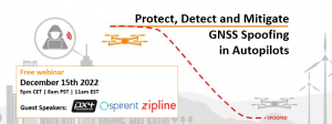
As drones are becoming a popular mode of delivery, surveillance, inspection, and mapping, they need to be resilient to spoofing. On Dec. 15, Septentrio hosted a webinar about detecting, mitigating, and protecting against spoofing on UAV autopilots.
Topics discussed included how GPS/GNSS technology fit into the autopilot ecosystem, signs of GPS spoofing and UAV vulnerabilities, realistic demonstrations of spoofing, how to mitigate spoofing, and autopilot compatibility with resilient GPS modules.
Wim De Wilde, R&D Team Leader at Septentrio, facilitated a presentation on vulnerabilities of UAVs. It included detecting signal anomalies and inconsistencies in GPS receivers to flag spoofing, technology used to spoof or hijack drones, and recommendations to prepare autopilots before take-off.
The next presentation, by Ramon Roche, General Manager at DroneCode Foundation and PX4 Autopilot, explained PX4 products that have built-in resilient GPS receivers. Greg Lopes, Hardware Design Engineer at Zipline, further elaborated about the importance of having robust, resilient GPS receivers to mitigate spoofing as it relates to Zipline’s delivery drones.
Figure 1
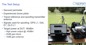
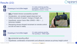
One of the final presentations was a case study of an in-field simulation and spoofing test by Jack Ackermann, Director of Product Line Management at Spirent. The case study preparation and test results that were discussed in the webinar can be seen in Figures 1 and 2.
Septentrio holds frequent webinars, with knowledgeable guest speakers, regarding topics related to GPS/GNSS technology. Find previous webinars and learn about upcoming ones here.
M3 Systems Belgium’s Haps-Augmented Search-And-Rescue Demonstrations System (HASARDS) project is looking to improve positioning of the global collaborative Copas-Sarsat search-and-rescue system by using its high-altitude platform system (HAPS).
The project is designing features for the system, such as carrying out geolocation with HAPS imagery and establishing communication between individuals in distress and emergency services.
While conducting HASARD, researchers were able to document system enhancements, execute a piloted flight-test campaign to create a realistic distressed aircraft carrying a second-generation beacon and future HAPS, and develop and operate a second-generation beacon signal simulator and HAPS system simulator.
Researchers found that using HAPS independent of Cospas-Sarsat adds value to search-and-rescue operations, providing location details via data fusion and georeferenced imagery while relaying communication between SAR teams and people in distress.
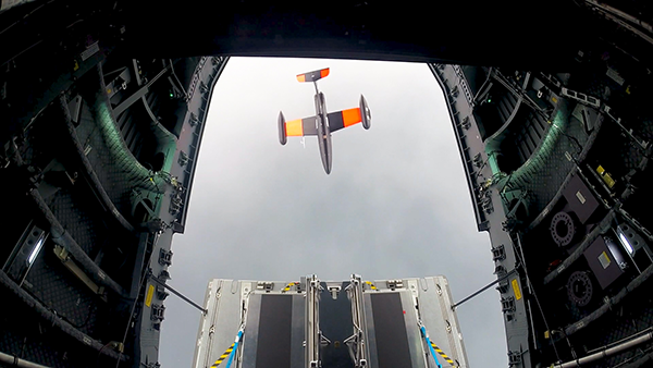
Germany has successfully launched the Future Combat Air System (FCAS) Remote Carrier demonstrator, released by an A400M.
The launch was carried out by the Bundeswehr Technical Center for Aircraft and Aeronautical Equipment (BAAINBw) and the German Aerospace Center (DLR), with collaboration from Airbus and German companies SFL and Geradts.The Remote Carrier demonstrator — an altered Airbus Do-DT25 drone — was launched from a device created specifically for the A400M to release remote carriers.
After the remote carrier was launched, its Do-DT25 engines were ignited, and it continued to fly. Controls from the A400M were then handed to the ground operator who landed the drone successfully.
As a part of the launch, the A400M was also evaluated to determine its role in FCAS to serve as a UAV launcher. Because the launch results were successful, Airbus is aiming to have the multi-role air lifter serve as the host of remote carriers.
The remote carriers and A400Ms will have an integral role in expanding the use of unmanned systems by Airbus’s military transport aircraft in the FCAS.
The recommendation is based on demonstrations at Yuma Proving Ground, Arizona
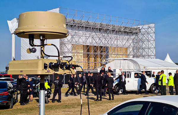
In September 2021, EnforceAir helped safeguard Pope Francis and a crowd of 60,000 in Slovakia. A ground-level tactical kit provided 360-degree azimuth coverage, fending off a rogue drone and sending it back to its original takeoff position. (Photo: D-Fend)
EnforceAir, a solution that counters small unmanned aerial systems (sUAS), has been recommended by the U.S. Department of Defense’s (DoD) Joint Counter-sUAS Office (JCO).
EnforceAir was recognized for its RF detection and mitigation, its demonstrated impressive effectors and its ability to force land certain drones. D-Fend Solutions’ EnforceAir was the only RF cyber takeover technology named.
EnforceAir automatically executes cyber drone detection and takeover mitigation of rogue drones for safe landings and outcomes, empowering security agencies and professionals with control while preserving operational continuity.
The JCO recommendation is the result of a formal U.S. government evaluation event held at Yuma Proving Ground in April 2022.
“It’s an honor to be recognized by the U.S. DoD Joint C-sUAS Office, following a rigorous demonstration and evaluation” said Zohar Halachmi, Chairman and CEO of D-Fend Solutions. “We’re excited to provide continued support for the counter-drone mission, within a layered defense, integrated in the most advanced C-UAS systems for the nation’s defense.”
EnforceAir is D-Fend’s flagship offering. With hundreds of deployments worldwide, EnforceAir focuses on the most dangerous drone threats in the military, public safety, airport, prison, major event and critical infrastructure environments.
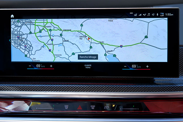
The BMW 7 Series rolls out SAE Level 2+ at a speed of 130 km/h in the United States and Canada. HERE also provides the BMW 7 Series with Predictive Routing and Real-Time Traffic information.
BMW Group is using the HERE Technologies HD Live Map to enable hands-free driving in the United States and Canada, starting with its 7 Series.
Following a long-standing collaboration between BMW and HERE on next-generation mapping capabilities, HERE now provides high-definition maps for Level 2+ automated driving capabilities in series production vehicles.
The BMW 7 Series is the automaker’s first production vehicle to launch with SAE Level 2+ automated functionalities at a maximum speed of 80 mph (130 km/h). The function enables hands-free driving on interstates and highways, provided drivers remain focused and ready to take control.
Photo: HERE Technologies
The HERE HD Live Map will be integrated into additional BMW models as automated driving capabilities increase across vehicles, roadways and regions.
The HERE HD Live Map consists of rich, highly accurate and fresh layers of data to support the vehicle in knowing exactly where it is on the road, and what road features lie ahead.
HERE HD Live Map helps a vehicle to proactively adjust its behavior to upcoming road characteristics.The lane-level data serves as a redundant source of information to the onboard sensors, providing additional safety assurances for the system.
Photo: BMW
The BMW 7 Series is also the first vehicle to deploy HERE Predictive Routing, a cloud-based routing functionality that learns individual driving patterns to propose more personalized journeys.
In addition, the BMW 7 Series uses HERE Real-Time Traffic across 70 countries. The service delivers drivers detailed information on traffic congestion with lane-level precision and potential road hazards ahead, with auto re-routing capabilities, helping drivers stay safe and save time.
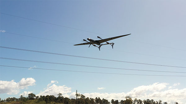
The Carbonix Volanti vertical take-off and landing (VTOL) drone. (Photo: Carbonix)
Fugro is partnering with Australian drone manufacturer Carbonix to establish a new long-range drone capability. It is Fugro’s first partnership working towards long-range beyond-visual-line-of-sight (BVLOS) missions, bolstering Fugro’s existing geographic information system (GIS) capability.
Carbonix will supply Volanti and Ottano vertical take-off and landing (VTOL) drones over the next 27 months, to further enhance Fugro’s remote operations.
Fugro is engaged in the transition to remote and autonomous operations with a global network of nine remote operation centres (ROCs). From these centers, Fugro operates boats and other vehicles, and provides survey, inspection and piloting services to the global maritime industry.
Carbonix will support Fugro’s Australian long-range maritime and land projects from the sky, using aerial surveying and data-capture technology, while integrating with Fugro’s ROCs for the joint development of systems technology and capabilities.
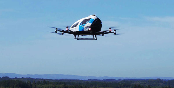
EHang deployed its EH216 eVTOL for flight trials in Europe including the recent Air Mobility Urban-Large Experimental Demonstration. (Photo: EHang)
EHang will deploy its EH216 autonomous aerial vehicle in a European Union-funded project that is assessing how the European Geostationary Navigation Overlay Service (EGNOS) could be used for electric vertical-takeoff-and-landing (eVTOL) aircraft operations.
The fully autonomous, all-electric vehicle will be used for flight trials at Lleida-Alguaire Airport in Spain as part of the Satellite Based Augmentation System Adoption in Multicopter VTOL Aircraft (SAMVA) program.
As part of an initiative of the European Union Agency for the Space Programme (EUSPA), the SAMVA project is tasked with establishing how EGNOS could support planned air mobility services, including eVTOL air taxi flights. It is also intended to prepare for uncrewed vehicles to use the new U-Space concept for managing autonomous or remotely piloted aircraft.
Aeroports de Catalunya will help China-based EHang to establish an operational center at its Lleida-Alguaire facility in the Catalonian region of northeast Spain. The EH216 will use the EGNOS technology to conduct unmanned traffic management (UTM) tasks and to demonstrate how eVTOL aircraft could operate in urban environments, including to and from airports.
EHang is working to achieve Chinese certification for the two-seat EH216, which it intends to deploy with partners and customers for services such as air taxi and sightseeing flights. It also aims to get approval for its aircraft to operate in Europe and has been active in other air mobility partnerships in Europe, where it has provisional customers in places like Norway.
In October, EHang completed its participation in the European Union’s Air Mobility Urban-Large Experimental Demonstration (AMU-LED) with a series of flight tests in Spain. The company — one of 16 consortium members in the AMU-LED program — demonstrated the EH216 at the Rozas Airborne Research Center, which is part of Spain’s National Institute of Aerospace Technology.
“The SAMVA project will unleash EGNOS capabilities aboard EHang’s EH216 AAV to provide precise and integral navigation guidance and support U-Space airspace integration,” said Victoria Jing Xiang, the company’s chief operating officer for Europe and Latin America. “Our participation in this project reflects the meaningful progress we’ve made overseas with our strong technologies as our global footprint expands.”
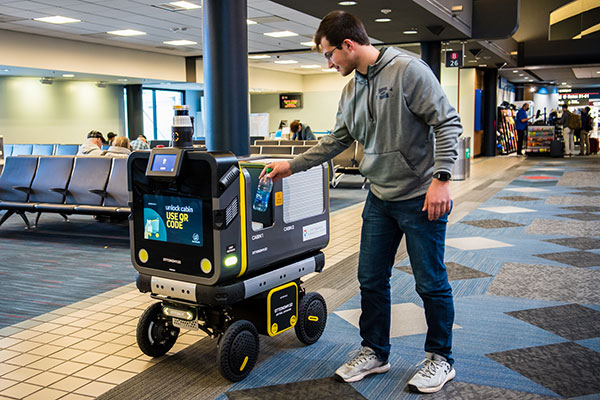
Ottonomy.io partners with Posten Norge for first-mile supply chain automation with autonomous robots
One of Europe’s largest postal services, Posten Norge, is testing the future of logistics delivery with Ottobots in Oslo.
Ottobot maker Ottonomy.io is collaborating with Posten Norge AS and Holo on trials for automating first-mile delivery in an effort to pave the way for autonomous delivery. See the project page.
The Posten Group is a post and logistics group that develops and provides post, communications and logistics services in Norway and the Nordic region. Holo is an implementer, integrator and operator of autonomous vehicles in the region.
An Ottobot delivers product orders to airport travelers. (Photo: Ottonomy)
The partnership with one of Europe’s largest logistics companies is oriented towards testing how autonomous robots can improve intra-logistics, especially in city centers. Posten Norge will be leveraging Ottobots for first-mile pick-ups, receiving and delivering goods for AMOI, a Nordic digital marketplace, from the busy Aker Brygge metropolitan area in Oslo.
“Autonomous robots have previously been tested by other companies with the focus entirely on final delivery to the customer,” said Sven Richard Tønnessen from Posten’s Department of Emerging Technology. “We want to evaluate how robots can become part of Posten’s future logistics solutions.
“This project, which utilizes both humans and robots, offers many new opportunities for increasing efficiency and productivity for our organization,” Tønnessen said. “We will continue to utilize our existing pool of human couriers for delivering goods to the customers, while the robot takes care of the intra-logistics part of the supply chain.”
Conquering the First Mile
The first mile has been a pain point for organizations in metropolitan areas. First-mile delivery involves moving products from the manufacturer’s or retailer’s warehouse to a central holding center. From this location, a carrier, shipping company or logistics partner picks up the products and takes it to the next leg in the destination.
“The logistics with delivery vans at Aker Brygge is extremely demanding in terms of parking and time consuming,” said Kenneth Tjønndal Pettersen, Posten Norge. “Together with our partners, we want to test the various applications for autonomous technology, which can enable simpler logistics and reduced noise in the cityscape.”
A recipient of the 2021 Sustainability Product of the Year award by Business Intelligent Awards, Ottobot will be used to determine how Posten Norge AS can increase sustainability and efficiency for the logistics supply chain in the future.
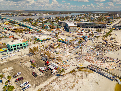
A photo taken in the aftermath of Hurricane Ian shows the massive destruction on Fort Myers beach. (Photo: felixmizioznikov/iStock/Getty Images Plus/Getty Images)
Not to harp on an event that’s already passed out of the headlines and national coverage, but Hurricane Ian — a Category 4 storm that hit Florida in September — was full of destructive winds and caused major damage that could be with us for years before things get fixed. One source also indicated that so far we have lost 157 people, mostly from drowning — nothing will ever fix those losses.
So harp on I will, especially about the role drones and drone pilots played in rescuing survivors, and determining and mitigating effects of the storm.
The place that took the hurricane hardest was Fort Myers on the southwest Florida coast. The following video is from a security camera.
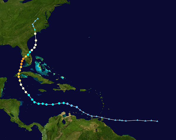
While Hurricane Ian was making a mess of Cuba and crawling over the Caribbean and into the Gulf of Mexico, drones were already flying over areas where the storm could cross from the Gulf onto land — initially forecast around Tampa. But the forecast landfall continued to drift south, over where I live in Venice and 150 miles south of Tampa to Fort Myers.
Before landfall, drone operators in Fort Myers were gathering video/geolocation information on buildings and streets in the path that the forecast 14-foot storm surge might take. They identified areas of potential damage and places people might need rescue.
Map plotting the storm’s track and intensity using data from the National Hurricane Center and a NASA image. (Image: public domain/FleurDeOdile/Wikipedia)/
After the storm hit, first responders began searching more than 400 destroyed houses in Fort Myers, some using the pre-storm drone video to rescue any trapped survivors.
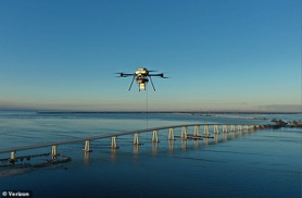
The need was not only for access in difficult conditions, but also for communications. AT&T reportedly got cell coverage up quickly in a couple of areas, and Verizon flew tethered drones (capable of flying for up to 1,000 hours) to restore phone coverage over a circular radius area of five to seven miles. Verizon also hooked up generators and engaged satellite internet coverage for local use, and took a portable cell-site on a barge out to Sanabel Island, which had been cut off from the mainland. T-Mobile put generators at cell-sites that lost power and deployed satellite and ground-based portable cell coverage.
Verizon tethered drones provided cellular service for first responders. (Photo: Verizon)
Powerful Drone
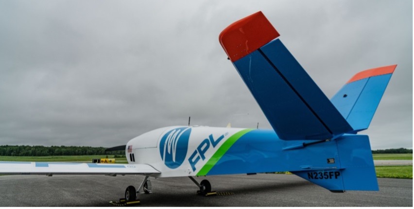
Loss of power was another issue. Florida Power and Light (FPL) flew its recently acquired fixed-wing FPLAir One drone to assess damage to its power distribution infrastructure, which supplies about 12 million people on Florida’s west coast.
FPL drone used in power loss assessment. (Photo: FPL)
Using the drone in damage assessment efforts enabled FPL to get suitable crews to the right places early in the recovery effort.
FPLAir One is a group 4/5 large UAV. It appears to be a Navmar Applied Sciences Corporation (NASC)/Sonex Aerospace TEROS unmanned aircraft, which is based on an earlier Sonex-powered glider design introduced in 2003. Because of this heritage and its rugged airframe, the TEROS is ideally suited for flights in high wind conditions — great for FPL’s long-range pre- and post-storm assessment application using FLIR and video cameras.
The drone’s extensive prior airframe proving is assisting NASC/Sonex in its quest for certification of TEROS by the Federal Aviation Administration (FAA). FAA certification will ultimately support its integration into the National Airspace System (NAS) and allow operators to move on from the individual FAA approvals required for each operational drone scenario.
Drones to the Rescue
The principal application for hundreds of drone flights by several organizations was search and rescue for missing residents, mostly in the flooded area in and around Fort Myers. Drones also helped rescue people in North Port, where floodwater was as high as four feet, collapsing roofs and trapping people in their homes.
Skydio provided drones for several search-and-rescue programs by police and other agencies, as well as coaching personnel who might lack experience in flying them. More than 500 drone flights were accomplished in the first days after the storm, a large number using autonomous flight capability, greatly assisting rescue efforts to locate trapped people. First responders were also able to determine whether access was possible, or what steps were initially needed to even enable access.
Insurance companies are also using drone assessment video, determining the level of damage to homes and vehicles, in an effort to put assistance where it was most needed early on. Using artificial intelligence to align food-stamp users with badly damaged homes identified on satellite images in Lee, Collier and Charlotte counties, GiveDirectly offered immediate $700-assistance to many survivors. If all these offers were accepted, the cost could be as much as $2.4 million in no-strings-attached immediate aid for those worst hit.
In the aftermath of the largest, most damaging hurricane to hit the United States since 1935, volunteers, first responders, drone pilots, aid agencies, and power, communication and insurance companies all made use of drones. These agencies and companies are still helping many thousands of people to survive and start the long task of picking up the pieces of their lives.
The BLK2FLY, recognized for its productivity and innovation, is a fully integrated autonomous flying laser scanner. It’s part of Hexagon’s BLK suite of autonomous reality capture sensors designed for speed, portability, ease-of-use and mobility.
To compile the list, TIME solicited nominations from TIME’s editors and correspondents around the world, and through an online application process, paying special attention to growing fields — such as the electric vehicle industry, green energy and the metaverse. TIME then evaluated each contender on key factors including originality, efficacy, ambition and impact.
“Having our reality capture technology recognized by TIME as one of the year’s best inventions is both humbling and inspiring. It validates our mission to build Smart Digital Realities that empower an autonomous, sustainable future,” said Hexagon President and CEO Ola Rollén. “Our technologies aim to change the world for the better, turning concepts that were once thought impossible into real solutions that benefit everyone. By optimizing quality, productivity, efficiency and safety — profitably — we can help industry achieve sustainability through mitigated risk, less waste and reduced cost.”
As a lidar-based unmanned aerial vehicle (UAV), the BLK2FLY addresses costly and complex issues, quickly and accurately capturing everything from large outdoor spaces to complex structures and environments.
For example, when renovating building structures, it can easily capture the exterior dimensions of previously inaccessible or difficult-to-reach areas such as rooftops and facades. The resulting colorized 3D point clouds are instrumental in building information modeling (BIM) processes, documenting site conditions and improving an asset’s operation, from infrastructure to utilities to industrial facilities.
What is the most promising approach to increasing the location accuracy of smartphones?
Ismael Colomina
“In addition to the use of increasingly available augmentation services, such as Galileo’s free High-Accuracy Service (HAS), I see two development directions that may help, particularly in the context of positioning in urban areas where smartphones are most used. One is the use of 3D city models — in general, 3D geoinformation — to compensate for multipath, non-line-of-sight and occlusion effects. The other is to use signals that are robust against those effects, which today are only available in geodetic-grade receivers.” — Ismael Colomina, GeoNumerics
For the navigation of autonomous vehicles, will GNSS become essential, or will it be relegated to a secondary role by robotic navigation methods?
John Fischer
“The PNT solution cannot be from a single source because autonomous navigation requires high integrity. Therefore, it’s not that GNSS will be relegated to secondary status, it’s that no one method will be primary. An intelligent fusion of diverse sensors —including GNSS — will provide the PNT solution along with an integrity metric that safeguards operation. The various sensors must agree. If they don’t, no trust can be put into the solution and autonomous navigation will cease. The definition of a new integrity metric that quantifies this trust level is needed.” — John Fischer, Orolia
Ellen Hall
“Because GNSS provides high precision and widely available PNT, it will continue to be a critical component in navigation while working with computer vision, inertial measurement units (IMUs) and lidar through sensor fusion. As a secondary component, GNSS serves a vital role for localization and validation.” — Ellen Hall, Spirent Federal Systems
InfiniDome has released GPSdome 2, its newest anti-jamming solution. The cost-effective and lightweight device provides simultaneous dual-frequency protection from three directions of attack.
GPSdome 2 is a high-end solution tailored to defend small- to medium-sized tactical UAVs as well as manned and unmanned ground vehicles.
Disruptions in critical positioning, navigation and timing (PNT) data mean loitering munitions that never find their targets, UAVs that fall to the ground, and ground vehicles that cannot be managed.
With a small form factor (500 g, 87 mm x 91 mm x 61.55 mm) and minimal power consumption, GPSdome 2 is suitable for loitering munitions as well as drones and UAVs, increasing resiliency while prolonging mission time and providing a superior return on investment. Fully retrofit and completely standalone, the system is compatible with almost any off-the-shelf GNSS receiver on the market as well as standard active GNSS antennas, meaning that it can be integrated into existing GPS systems or into new product lines, manned or unmanned.
With sophisticated algorithms and a proprietary RFIC, GPSdome 2 analyzes RF interference in the environment and combines multiple antenna patterns to create and dynamically steer three nulls in the direction of any hostile signal.
GPSdome 2 provides simultaneous dual-frequency protection (GPS L1 + L2 or GPS L1 + GLONASS G1), creating up to three nulls, protecting from three jamming directions within each band in real time, making it suitable for PNT applications.
The GPSdome 2 is a dual-use, non-ITAR device and comes with optional mil-spec compliance. It has been chosen by an Israeli defense contractor for integration with its platforms.