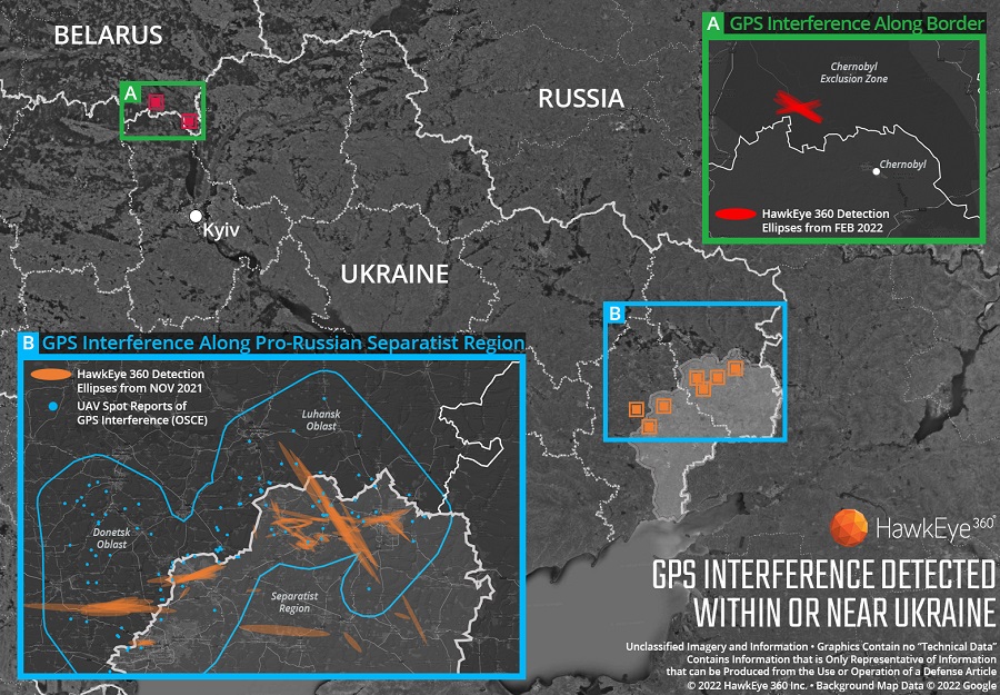
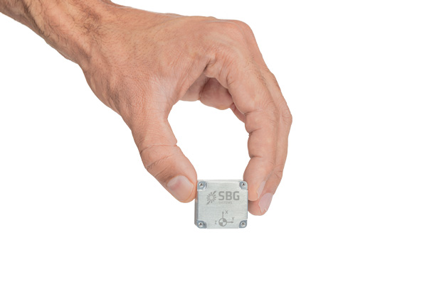
Technology from HawkEye 360 Inc. has detected and geolocated extensive GPS interference over Ukraine, starting months before the Russian invasion. HawkEye 360 uses satellites to monitor radio-frequency signals that might threaten military and civil navigation applications.
The capability was tested in 2021 in a variety of exercises and is available as part of HawkEye 360’s RFGeo signal product catalog.
When HawkEye 360 analysts examined Ukraine over the past five months, they discovered continued and increased GPS interference across the region. The data showed extensive GPS interference in November 2021 along the boundary of the pro-Russian separatist-controlled regions in Luhansk and Donetsk.
Open-source information confirmed unmanned aerial vehicles (UAVs) operating in the area were disrupted because of lost GPS connections.
In February 2022, HawkEye 360 detected GPS interference along the border between Ukraine and Belarus, shortly before the Russian invasion started. This February activity occurred north of Chernobyl within the Chernobyl Exclusion Zone, demonstrating the integration of electronic warfare tactics into Russian military operation to further degrade Ukraine’s ability for self-defense.
“GPS is a fundamental ‘global commons’ service that all modern economies depend upon. GPS signal interference has the potential to significantly disrupt air travel, logistics, finance, transportation, communication and many other basic services,” said John Serafini, CEO of HawkEye 360.
“Whether unintentional or deliberate, interference that prevents people, vehicles, ships, and planes from determining accurate locations can be devastating to government and commercial activities alike,” Serafini said. “Since HawkEye 360 can monitor hundreds of millions of square kilometers daily, we are able to notify clients when and where GPS interference occurs, so they can respond quickly to mitigate the impacts.”
Interference can be inadvertent by equipment operating too close to GPS frequency bands. However, deliberate interference has spiked across the globe due to the low cost, ease of deployment, and general availability of GPS jamming technology.
Military forces use GPS jammers to obscure and protect critical troops, facilities and equipment from attack and can be a leading indicator of future military activity. Drug cartels use GPS jammers to deter surveillance from overhead drones. Use of jammers is illegal in most developed nations.
HawkEye 360’s detection product offers a valuable capability to monitor for illicit and unintentional GPS interference that can significantly disrupt critical location services, representing the company’s global commitment to make the world a safer place, the company said.
Florida Power & Light to deploy 13 autonomous drones, with plans for hundreds more in coming years to monitor statewide power grid
UAV company Percepto will deploy autonomous drones to monitor Florida power substations and distribution grids across the state.
Florida Power & Light (FPL) will deploy drone-in-a-box technology statewide, which Percepto claims is the largest commercial autonomous drone project in the world.
FPL serves the northeast and southern half of Florida. (Image: Florida Public Service Commission)
Serving more than 11 million people in Florida, FPL uses Percepto’s Autonomous Inspection and Monitoring (AIM) solution powered by drones to perform routine infrastructure inspection and monitoring.
In the first phase of the project, 13 drones will take flight in the West Palm Beach area this year, with long-term plans to field hundreds of Percepto over the next five years.
The drone-in-a-box solution was the first to pass Level 5 hurricane testing at a wind speed of up to 155 mph, making it suitable for minimizing incident response times and power outages in Florida.
Percepto has served FPL since 2018, working closely to develop optimized drone monitoring solutions and build consensus and compliance with Federal Aviation Administration (FAA) regulations. The FAA issued a nationwide waiver for FPL to fly Percepto drones for surveillance and inspection purposes at sites owned and serviced by FPL.
As part of its ongoing work with the FAA, Percepto is a member of the Beyond Visual Line of Sight (BVLOS) Aviation Rulemaking Committee (ARC) that has provided its regulatory recommendations to fully incorporate highly automated BVLOS operations flights in the national airspace.
The drones in operation across the state will be coordinated on a single platform through Percepto’s AIM solution. With Percepto AIM, drones can be operated remotely to ensure that they work together in sync, providing maximum coverage at the sites they monitor.
DroneShield has begun releasing a software update across its counter-unmanned-aerial-system (C-UAS) devices, including portable, vehicle-based and fixed-site devices. The devices are used by the military, the intelligence community, U.S. Homeland Security, law enforcement, critical infrastructure and others.
The updates will be rolling out across DroneShield devices globally in the coming week, with heightened urgency given the widespread use of drones in Ukrainian and Middle Eastern conflicts. The technology upgrade is validated by deployments with the U.S. Air Force and Australian Army.
Enrolled devices receive quarterly firmware updates of the proprietary DroneShield RFAI artificial intelligence engine. Some of these updates are major enhancements, such as this 2Q22 release.
Major upgrades include:
Site Install Wizard. The new Spectrum Viewer mode, in which C-UAS detection devices scan the deployment area for optimal sensor placement
Machine Learning in the Loop. This option enhances the RFAI engine from the data received by the user.
Both features were added in response to end-user requirements.
New offerings will deliver accurate navigation to industrial applications even in areas where GPS is unavailable
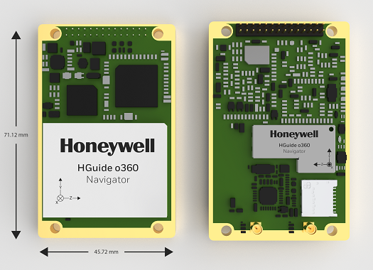
The HGuide o360 Navigator. (Photo: Honeywell)
Honeywell has expanded its HGuide industrial navigation portfolio with three new technologically advanced navigation systems — the HGuide o360 INS/GNSS navigator, HGuide n500 inertial navigator and the HGuide g080 GNSS receiver.
The new HGuide products are designed for a wide array of industrial and autonomous applications across air, land and sea vehicles and related equipment.
The HGuide o360 navigationsystem is a compact single-card, all-attitude inertial navigation system (INS) GNSS navigator that can deliver an accurate and robust position and attitude navigation service, even through GNSS-challenged or denied environments, to industrial and autonomous applications. It provides the features and compatibility needed for a simple integration.
“The HGuide o360 is an engineering marvel and a technological breakthrough. There are no similar competing products in the industry today that can achieve such a high-performance level at this price point and size,” said Matt Picchetti, vice president and general manager, Navigation & Sensors, Honeywell Aerospace. “The entire HGuide product line is suitable for a wide range of industries, including autonomous vehicles, marine and a host of industrial applications where accurate positioning and attitude information is required in real time.”
The HGuide o360 INS/GNSS navigator contains a powerful dual antenna, multi-frequency, multi-constellation, real-time kinematic (RTK) GNSS receiver, Honeywell’s i300 inertial measurement unit (IMU) technology, and a high-grade calibrated magnetometer.
The HGuide o360 is designed for platforms that require high-performance navigation data in an ultra-low size, weight and power (SWAP) package.
The HGuide n500 inertial navigator is a navigation-grade bring-your-own-GNSS all-attitude navigator that supports continuous position and attitude navigation even during prolonged GNSS outages. The HGuide n500 is built on Honeywell’s HG4930 IMU plus the Honeywell HGuide Sensor Fusion software.
The HGuide g080 GNSS receiver is a dual-antenna, triple-radio frequency, all-constellation GNSS receiver that delivers heading and positioning down to sub-centimeter levels even in GNSS-challenged environments. It includes an onboard IMU to allow tracking during short GNSS outages and enable smooth and fast reacquisition. The product is available with or without RTK functionality.
Inertial navigation systems are highly critical in navigation and comprise an IMU, a GNSS receiver and sensor fusion software. These components work together to calculate position, orientation and velocity to deliver critical navigation information in GNSS-denied areas such as urban canyons, bridges, tunnels, mountains, parking garages and dense forests.
A roundup of recent products in the GNSS and inertial positioning industry from the April 2022 issue of GPS World magazine.
OEM
GNSS+5G Antenna
9-in-one combination antenna with dual-band GNSS
Photo: Taoglas
The Taoglas MA990 Guardian antenna is a 9-in-1 combination antenna with dual-band GNSS (L1/L2) and globally supported cellular (5G/4G). It has been designed to support emerging market demand for modules that cover specific 5G/4G bands. Two of its eight cellular MIMO antennas cover from 600 Mhz to 6,000 MHz, while another two are optimized for 3,000 MHz to 6,000 MHz to cover high-band 5G and C-band/CBRS applications. The customizable antenna is designed to operate on all global carrier networks and is future-proofed to work with the latest 5G routers on the market. Housed in a low-profile, robust, IP67-rated waterproof, adhesive-mount external enclosure, the MA990 is designed for space-constrained, mission-critical applications, including asset and vehicle tracking, first-responder vehicles and high-definition video sources such as surveillance cameras.
The Boreas fiber-optic-gyroscope inertial navigation system (INS) is an ultra-high accuracy, strategic-grade INS offering a reduction in size, weight, power and cost. It is based on Advanced Navigation’s new digital fiber-optic gyroscope (DFOG) technology. The Boreas is targeted at applications requiring always-available, ultra-high accuracy orientation and navigation including marine, surveying, subsea, aerospace, robotics and space. It delivers strategic-grade bias stability of 0.001 deg/hr. This allows it to achieve ultra-high roll/pitch accuracy of 0.005 degrees and heading accuracy of 0.006 degrees. The Boreas allows for full independence from GPS with dead-reckoning accuracy of 0.01% of the distance traveled with an odometer or Doppler velocity log. In addition, the Boreas features ultra-fast gyro compassing, taking only two minutes to acquire heading in both stationary environments or on the move. Gyro compassing allows the system to determine a highly accurate heading of 0.01 degrees secant latitude without relying on magnetic heading or GPS.
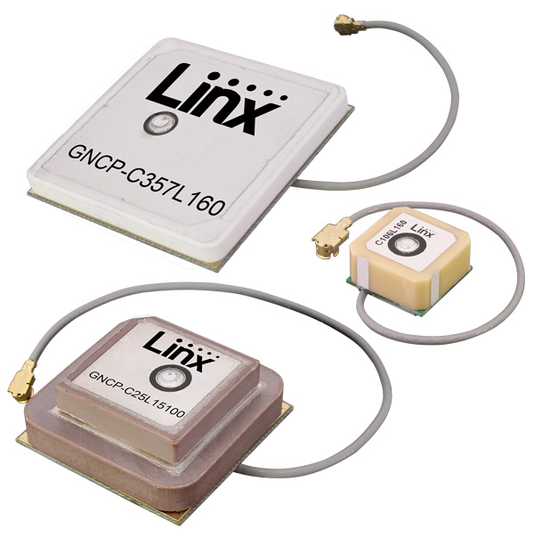
Seven new GNSS active ceramic-patch antennas support global GNSS applications including GPS, Galileo, GLONASS, BeiDou, NavIC and QZSS systems in the L1/E1/B1, L2/E5/B2B, and L5/E5/B2A bands. Each antenna integrates a high-gain low-noise amplifier (LNA) and right-hand circular polarization (RHCP) to provide a high-performance solution for GNSS signal reception. Each active GNSS antenna has either a 60-mm or 100-mm coaxial cable terminated in a MHF1/U.FL-type plug (female socket) connector. They also meet the need for multi-band L1/L2, L1/L5, and L1/L2/L5 GNSS offerings.
The Pulse-40 inertial measurement unit (IMU) is a tactical-grade IMU designed for high performance in harsh conditions but miniaturized for applications where precision and robustness matter in all conditions. Use cases include warfare systems, satellite communications, robotics, lidar devices, gimbals, cameras and inertial navigation systems (INS). The Pulse-40 IMU provides six degrees of freedom. It integrates micro-electromechanical (MEMS) three-axes accelerometers and gyroscopes in a unique redundant design that allows the device size to shrink while pushing performance to its maximum. Among the performance specifications, the Pulse-40 features excellent gyro and accelerometer bias instability of 0.8°/h and 6 µg respectively, enabling long dead-reckoning and maintaining excellent heading performance. With sensors featuring extremely low vibration rectification error (VRE), the Pulse-40 can sustain high vibration environments, up to 10 g root-mean-squared. An embedded continuous built-in-test ensures data reliability during operation, a key parameter for critical applications. Features include 12 grams, 0.3W power consumption; ultra-low noise gyro (0.08°/√h) and excellent gyro bias instability (0.8°/h); high-precision accelerometers (6 µg); MIL-STD 810-qualified for shocks and vibrations; high bandwidth (480 Hz) and high data rate (2 KHz); highly tested and calibrated from –40° C to 85° C; and no export restrictions.
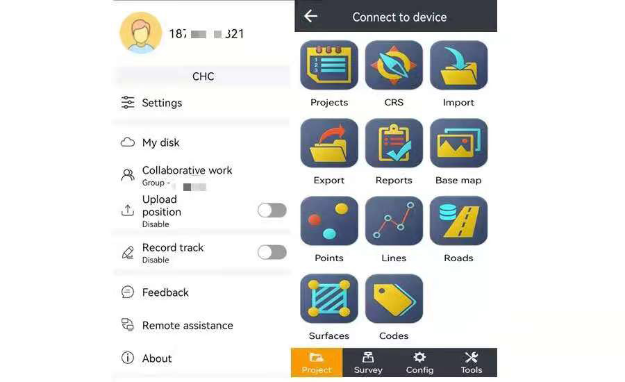
Adds online services for field surveying and mapping
Photo: CHC Navigation
LandStar version 7.3.7 adds cloud-based services and remote support features to simplify surveyors’ daily tasks. Online data storage and file sharing greatly facilitates interactions within a company and between field operators. LandStar 7’s remote assistance feature allows support personnel to take control of the field crew’s devices. Users simply provide a remote code to grant control of their data controller and be guided efficiently to the solution. The new version of LandStar 7 further improves support for CAD files and operates faster when importing 20MB DWG or 200MB DXF basemap files. Users can directly click on points, lines and blocks to stake out. In addition, object symbols and colors are displayed in the same way as in the original CAD design, making it easier for users to identify them.
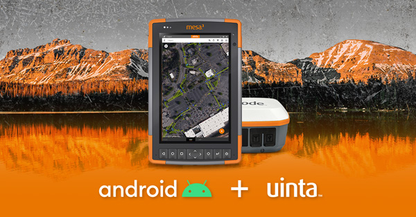
Uinta is now available for devices running on Android. This is particularly valuable for workers who prefer to use an Android tablet or smartphone as a data collector. Uinta’s intuitive and customizable user workflow makes land measurement and asset mapping easier for data collection in the field. Uinta can now be used on a range of smartphones and tablets, including Juniper Systems’ Cedar CT8X2 and Mesa 3 rugged tablets running on Android. When using Juniper’s Geode GNSS receiver and running Uinta on an Android phone or tablet, users create a total mapping solution. They can collect high-accuracy GNSS data on the Geode, record the data in Uinta software, and see the data on a mobile or tablet. The intuitive software includes project templates that can be modified to meet individual project needs. Uinta is commonly used in utility mapping; commercial and agricultural irrigation; industrial asset inspections and rounds; and numerous environmental sciences in forestry, wetlands, wildlife and vegetation mapping.
Visualize the present and simulate the future of Scottish cities
Photo: Bluesky
Scottish cities Edinburgh and Glasgow have been added to the growing coverage of MetroVista 3D city models. The data is available as ultra-high resolution 5-centimeter aerial photography with 16 points per meter (ppm) lidar. The data also is being processed to create a fully rendered mesh model suitable for use in a range of GIS, CAD and modeling software packages Acquired using the Leica CityMapper aerial sensor that simultaneously captures vertical and oblique imagery together with high-point density lidar, MetroVista data is becoming increasingly popular for smart city applications. Providing a geographically accurate and detailed 3D representation of the urban environment, MetroVista data provides insight for applications such as urban design, defense and security modeling, insurance assessments and utility and telecom planning.
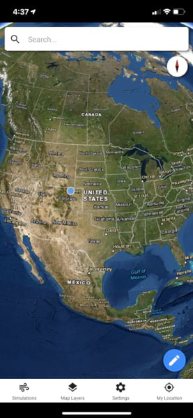
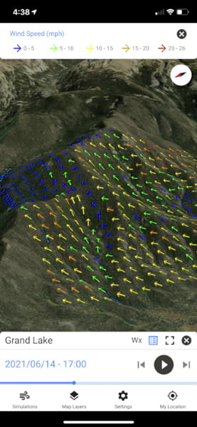
WindNinja is a high-resolution wind modeling app created for firefighters who need to quickly compute and visualize wind direction and speed simulations. The simulations provide them with situational awareness, help keep them safe, and help them conduct work such as burnout operations. The mobile app, developed using ArcGIS AppStudio from Esri, provides high-resolution, near-surface wind forecasts that include wind speeds and directions displayed on a map. The user selects an area of interest of 50 square kilometers or less, names the simulation, chooses a forecast duration of up to 15 hours, selects whether to receive an email or SMS notification when the simulation is ready to view, and then submits the request. The user also can select from a variety of basemaps and turn on data layers — vegetation, atmospheric, oceanic, land-surface imagery — collected by NOAA satellites.
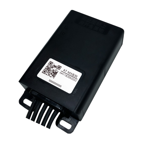
Intelligent control system meets urban transport requirements
Photo: Xiaoan Technology
The AT-MX intelligent control system for shared electric bicycles uses the latest ultra-low-power u-blox M10 GNSS technology to enhance the positioning performance of their fleet for improved compliance with increasingly stringent Chinese policy requirements. The growing popularity of shared micromobility solutions for short-distance urban travel has led municipal authorities around the world to introduce new legislation to mitigate their perceived negative impacts, for instance, with restrictions on where users can drive and park their vehicles. Meanwhile, vehicle operators and maintenance personnel need to efficiently locate vehicles requiring maintenance and gather reliable vehicle usage data to balance bicycle placement and operational safety. Enforcing regulatory compliance and optimizing operations both require the safe, accurate and efficient bicycle positioning solutions.
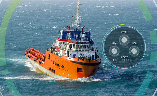
Ensures safe operations through reliable, robust and continuous positioning
Image: Hexagon
SPAN technology delivers a deeply coupled GNSS and inertial navigation system (INS) that provides robust, reliable and continuous centimeter-level positioning for operators to maintain safety and maximize uptime. Now available for the dynamic positioning of vessels, the GNSS+INS solutions can bridge outages in GNSS tracking and through short periods of radio-frequency interference, jamming or spoofing. It provides vessels with an added layer of resiliency and achieve continuous centimeter-level accuracy across all conditions. SPAN GNSS+INS technology is compatible with commercial inertial measurement units (IMUs) and scalable with the LD900 GNSS receiver, Quantum visualization software and APEX correction services. Features include continuous centimeter-level positioning made more robust and reliable through enhanced GNSS tracking and deep coupling of inertial measurements; rapid reacquisition of GNSS signals after outages or interruptions through a deep coupling process; constant monitoring of GNSS absolute positioning combined with heading, velocity and attitude measurements; and added positioning redundancy with system robustness against potential signal outages, interference or disruptions.
Ibtechar, one of Qatar’s top providers of practical innovation and turnkey solutions, has developed a drone tracker and a GPS-based system that ensure the safety and security of critical infrastructure, VIP residents, national borders, and military facilities. The customized solution is made by a Qatar-based team of researchers and technologists with extensive knowledge and expertise in applied research and counter-drone systems. It aims to secure airports, power lines, and other vital assets that can be targets for drone attacks. Prototypes have gone through 487 flight tests in 19 locations, as well as 676 drive and walk tests. Features include compatibility with GPS, GLONASS and BDS; real-time tracking, popup notifications and SMS alerts; smart geo-fencing; drone whitelists/blacklists; base-station triangulation (cell ID); IMU, tilt, vibration sensor, and NFC; and offline mode. The new tracking system can identify the operating drones by displaying the drone itself, its serial number, the commercial frequency used, and motion details (speed, altitude, azimuth, path, etc.).
DroneDeploy lets users capture, process and analyze data in one platform. Users can create high-resolution 2D and 3D interior and exterior maps and models accurate to between 1 cm and 5 cm. It is designed for individuals, teams or enterprises and is suitable for all use cases and industries. However, primary markets include agriculture, construction, mining, energy, roofing and inspection. Features include Mobile Flight App to capture images directly from
an iOS or Android device; Live Map to create real-time, sharable
2D maps; Autonomous Flight to preprogram routes; as well as
360 Walkthrough for a 360-degree, virtual tour through a 3D model of a site. Industry-specific features are available, such as Plant Health to help farmers measure crop health and viability.
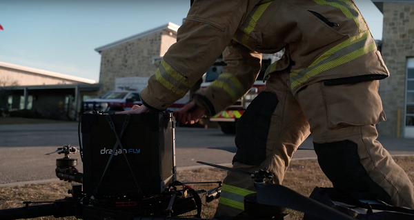
The first Draganfly humanitarian drone shipped to Revived Soldiers Ukraine (RSU) has arrived in Europe and will soon deliver insulin to hard-to-reach hospitals in Ukraine. Draganfly is a North American drone manufacturer.
RSU ordered 200 Draganfly medical response drones equipped with temperature-managed payload boxes that can transport up to 35 pounds of blood, pharmaceuticals, insulin/medicines, vaccines and wound-care kits. Because insulin is a temperature-sensitive product, quick and safe transportation of the hormone is a top priority.
About 2.3 million people in Ukraine live with diabetes. Many are Type 1 diabetics who need multiple daily injections of insulin to survive. For those living in high-conflict areas of the country, access to life-saving insulin is limited or non-existent.
NuGen Medical Devices donated the needle-free injection devices and 5,000 needle-free disposable syringes to be filled with insulin. Not only are life-saving medical supplies like insulin dwindling in Ukraine, but there is also an urgent need for many medicines across the country as hospitals have been under direct attack since Russia invaded on Feb. 24.
Draganfly medical relief drone. (Photo: Draganfly)
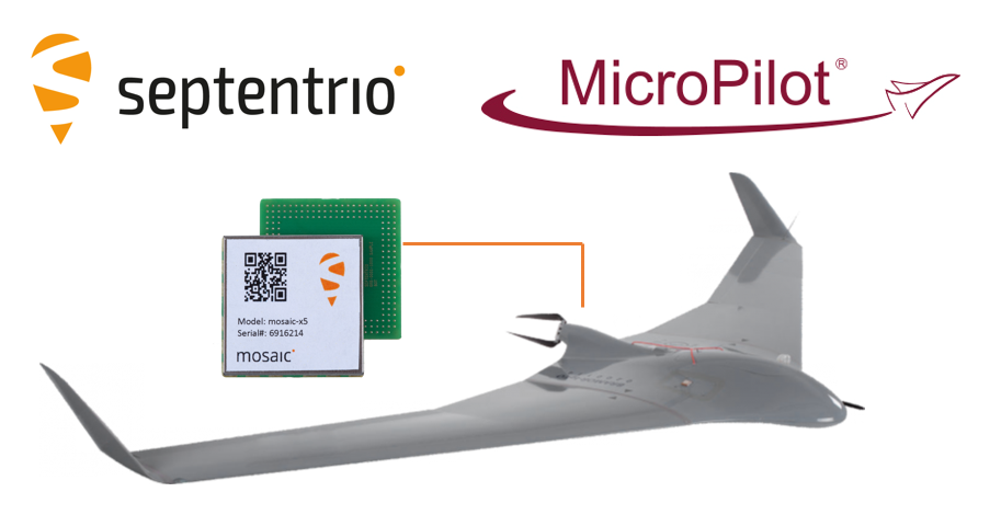
The collaboration ensures smooth and easy integration of high-accuracy GPS/GNSS positioning and professional-level autopilots into control systems where safety and reliability matter
Septentrio is collaborating with MicroPilot, maker of professional UAV autopilots.
Septentrio receivers, including the small form factor mosaic modules, as well as the OEM board AsteRx-m3, will support seamless integration of positioning and orientation into MicroPilot’s autopilot ecosystem.
MicroPilot chose Septentrio GNSS receivers for their resilience to radio interference such as jamming and spoofing, as well as security and robustness with high-accuracy real-time kinematic (RTK) positioning.
Self-interference or self-jamming is a common occurrence in UAVs, where devices such as cameras, servos or antennas, which emit electromagnetic radiation, are located close to the GPS receiver. Incorporating GNSS technology that is resilient to jamming and spoofing, in combination with reliable professional-level autopilots, is key to safe and secure flight navigation, according to Septentrio.
“Adopting new and resilient technology in UAVs is vital, and we want to ensure a smooth integration process into professional drone systems,” said Gustavo Lopez, senior market access manager at Septentrio. “We are very excited about the strong collaboration between Septentrio and MicroPilot, which now provides new alternatives to drone companies looking for safe and reliable flight operations.”
In addition to developing autopilots, MicroPilot provides supporting software and services that enable customers to use development time more efficiently, reducing time to market.
“Working closely with Septentrio gives MicroPilot the ability to better leverage resilient and robust GNSS technologies strengthening our offering to the professional UAV market for safe and reliable flight control,” said Howard Loewen, president of MicroPilot.
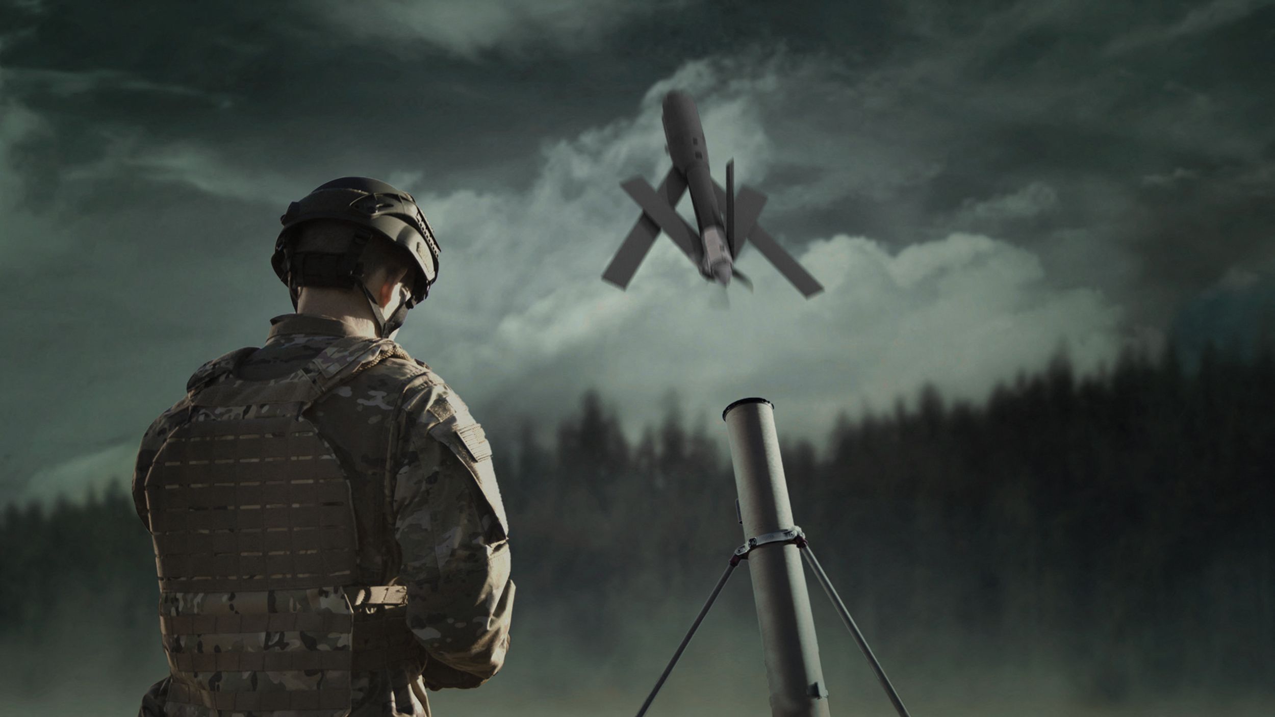
On April 21, the Pentagon announced an $800 million security package for Ukraine defense, including 121 tactical unmanned aerial systems (UAS) dubbed Phoenix Ghost drones.
According to the Pentagon, the drones were rapidly developed by the Air Force specifically to meet Ukraine’s requirements. The Ghost drones are manufactured by Aevex Aerospace and have similar capabilities to the single-use “kamikaze” Switchblade UAS from AeroVironment.
The U.S. is also sending at least 300 more Switchblade drones, according to CNBC, though which model has not been revealed. The 300 variant is designed to strike small targets. It can fit in a rucksack, weighs a little more than 5 pounds and has a range of 10 miles. The 600 version of the weapon is designed to destroy tanks and other armored vehicles. It weighs slightly more than 120 pounds and has a range of more than 40 miles.
AeroVironment is also donating more than 100 Quantix Recon UAS and operational training services to Ukraine’s Ministry of Defence and territorial forces. Using the actionable intelligence gathered by the Quantix Recon, operators can conduct quick mission planning and verification to help keep Ukrainian ground forces out of harm’s way. Delivery of the Quantix Recon UAS is independent of other AeroVironment tactical missile systems and UAS provided to Ukraine by the United States.
The Phoenix Ghost drone is similar to the single-use Switchblade drone from AeroVironment. (Photo: AeroVironment)
ComNav Technology has released a powerful and reliable UAV aerial mapping solution capable of centimeter-level positioning, providing high-precision photos and data for mapping professionals.
Based on the company’s K8 platform, the package consists of an E300 real-time kinematic (RTK) drone, flight-control software and an optional camera.
Featuring high accuracy, strong compatibility, long endurance, high performance and an easy workflow, the E300 drone package can meet the requirements of many different applications, including topographic survey, urban construction, forestry investigation, emergency rescue, 3D modeling, mining and surveying.
High Accuracy. The E300 RTK drone is embedded with a high-precision K8 GNSS module that supports GPS L1/L2/L5, BeiDou B1/B2/B3/B1C/B2a, GLONASS L1/L2, Galileo E1/E5-a/E5-b/AltBOC/E6 and QZSS L1/L2/L5. With Quantum III technology, the K8 GNSS module provides reliable and stable RTK positioning results.
The professional post-processed kinematic (PPK) software Compass Solution supports the full-constellation calculation, providing accurate positioning results.
RTK/PPK provides dual backup, one as a failsafe for another, to ensure acquisition of data. The built-in antenna further increases precision of photo position. EVENT synchronization technology can reduce camera trigger error and ensure high performance of the solution.
With its intelligent recognition algorithms, the E300 is able to capture high-resolution images consistently even in complex environments.Moreover, the E300 has a multipath redundancy design with key modules for safety.The solution can provide centimeter-level positioning results without ground control points, saving time.
Compatibility. Featuring a carrying capacity of 3 kg, the E300’s payload bay is compatible with a wide range of cameras, including C20, C50, LiAir VH2 and others. Payloads can be quickly and easily swapped in the field for maximum versatility.
Besides supporting standard NTRIP protocol, the E300 is compatible with all brands of base stations and continuously operating reference stations.
Long Endurance. The E300 is characterized by an ultra-efficient aerodynamic design. It reaches a 60-minute flight time without payload and 50 minutes with a basic payload, covering areas with a maximum 10-km radius per flight. In one flight, the E300 can map about 0.62 km² in 1.5-cm/px ground sample distance with one battery.
The E300 RTK drone features a simplified design for easy and rapid assembly within minutes while providing excellent stability and vibration resistance.
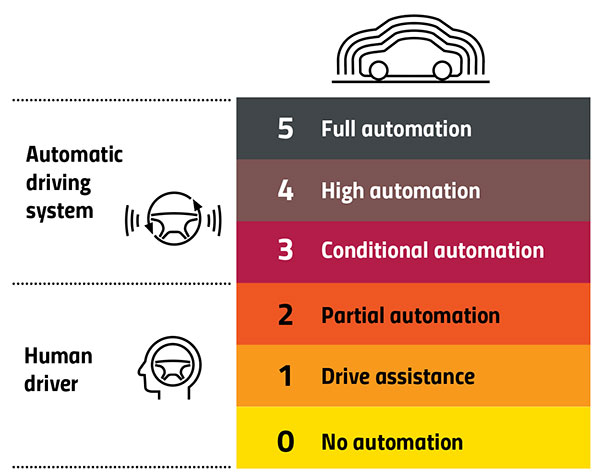
DeepRoute.ai, an international autonomous driving technology company, is offering a Robotaxi fleet equipped with its Level 4 autonomous driving solution, Driver 2.0.
Level 4 autonomous vehicles do not require human interaction in most circumstances, but a driver still has the option to manually override.
Image: GPS World
According to DeepRoute.ai, its advancement in autonomous technology previews the future of Level 4 consumer vehicles.
Composed of 30 SAIC Motor Marvel R SUVs, the Robotaxi fleet will deploy in Shenzhen, China, in the coming months.
Mass Production. Driver 2.0 was engineered for mass production and adoption by automakers. DeepRoute.ai projects mass production of Level 4 autonomous vehicles equipped with Driver 2.0 will begin in 2024 and be available for consumer purchase afterward.
DeepRoute.ai is collaborating with global automakers to achieve series production of Level 4 autonomous driving vehicles and expects to further reduce the current $10,000 cost of the solution by approximately 70%.
Driver 2.0 sensor configurations can be customized to meet automakers’ needs, equipped with two to five solid-state lidar scanners and eight cameras. Its proprietary low-energy consumption computing platform and inference engine combined with Nvidia Drive Orin systems-on-chip will allow the company to meet automotive-grade standards for series production more quickly, the company said.
DeepRoute.ai’s camera-based redundancy perception system guarantees autonomous capabilities should other sensors malfunction, in addition to 5G remote control and network safety redundancy fused into the safety-critical systems.
Level 4 self-driving can first be achieved in areas supported by rich data. Level 4 consumer vehicles on the road operating in a hybrid model will continuously gather additional data, laying the foundation for the scalability of Level 4 autonomous driving in other cities, the company said.
DeepRoute.ai plans to accelerate Level 4 commercialization through technology iterations in data collection and analysis, algorithm improvement, simulation and road testing.
Photo: DeepRoute.ai
With a 360-degree view and 200-meter perception range, the fleet offers high-performance Level 4 autonomous driving in an urban environment. The sensors are designed to be less noticeable and part of the auto’s chassis design.
The entirety of DeepRoute.ai’s Robotaxi fleet across Wuhan, Shenzhen, Hangzhou and Fremont, California, now encompasses a variety of models: GAC Aion, SAIC Motor Marvel R, Lincoln MKZ, Geely, Dongfeng Motors E70 and Ford Mondeo.
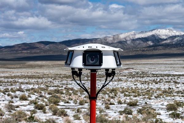
Iris Automation has announced the commercial availability of Casia G, a ground-based version of its detect-and-avoid surveillance solution.
Using the same patented artificial intelligence (AI) and computer-vision technology as Iris Automation’s onboard solutions, Casia G provides 360° optical detection with alerts. It enables operators to avoid both cooperative and non-cooperative aircraft for safe beyond-visual-line-of-sight (BVLOS) flight.
Casia G creates a perimeter of monitored airspace for UAVs to perform work safely, without additional payload. It’s suitable for operations in fixed or temporary locations, supporting drone-in-the-box operations and augmenting or replacing human visual observers. BVLOS flight for unmanned systems has been challenging due to right of way concerns, specifically the inability for unmanned aircraft to successfully see and avoid other aircraft.
“A human has sufficient visual acuity to see airborne traffic only within a +/-5 degree field of view around our focal point. We have to scan the sky, and are frankly not very good at it,” said Jon Damush, CEO, Iris Automation. “Casia G sees the entire sky, with uniform probability and resolution, 10 times per second — without distractions or breaks. This solution for airspace awareness covers a large majority of small UAS use cases, but at a price point that is economically viable and without complex integration.”
Casia G can be expanded by adding additional units in a mesh to create a network of detection nodes for large-area air risk mitigation. The system then provides a single feed of cooperative and non-cooperative air traffic, available to an operator’s traffic management system. This provides a path to approvals for both larger area and one-to-many operations by enabling a holistic view of the airspace, the company said.
Casia G has already obtained a BVLOS waiver on behalf of the City of Reno. Iris Automation is in the process of proving additional deployment patterns and concepts of operation with the FAA.
This month, we look at new applications that might interest even the most tech-savvy. From military Reaper unmanned vehicles being turned into civilian fire-fighters, through continuing drone flights on Mars, to e-scooters monitored by AI-system, the autonomous arena continues to grow.
Reaping Disaster-Response Benefits
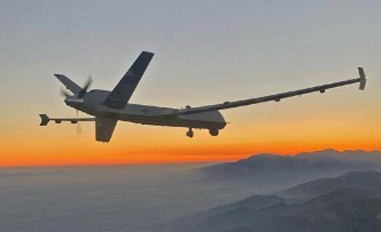
The General Atomics Reaper unmanned aerial vehicle (UAV) is usually a weapon of war. Most of us picture them loaded with missiles to be fired on terrorist hideouts, with video of the impact appearing on the six-o’clock news. Soldiers in small control shacks guide these worldwide attacks, while politicians watch the outcomes remotely with their own direct TV coverage. This is how we tend to think of these destructive systems.
However, Reapers recently have been helping fight the huge fires devastating the California landscape — a more humanitarian, supportive role for a military asset.
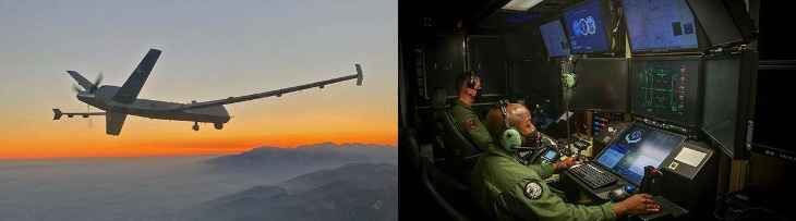
General Atomics Reaper UAV on patrol and remote pilots (Photos: California Air National Guard)
The California Air National Guard (ANG) has been assisting firefighters for many years by using helicopters and fixed-wing aircraft to determine the intensity of large California fires and to plot their boundaries.
In the past 10 years, with the availability of large reconnaissance UAVs and assistance from the Federal Aviation Administration to develop and approve operational procedures, an approach has been formulated to employ Reapers, with the potential to reduce costs and greatly improve response times.
Having large UAVs at altitude in civilian airspace requires an accompanying chase plane to ensure safe operation. With proven onboard detect-and-avoid capability and visibility through crew monitoring, the chase aircraft only monitors the Reaper’s climb to operational altitude. Using infrared and video from onboard cameras, data is downlinked and post-processed to create fire maps. Artificial intelligence (AI) automates this procedure to provide incident commanders with a near-real-time situational overview.
Besides mapping the fire, the incident commander can keep track of firefighters on the ground and gain a clearer picture of the fire’s intensity, rate of growth and direction. With a high altitude view of the landscape, Reaper pilots also help determine the best evacuation routes. Video downlinks provide real-time fire dynamics to commanders and even to firefighters on the ground who carry handheld devices.
When equipped with long-range fuel tanks, Reapers can remain on task for up to 18 hours. The pilot and systems operator in their remote mission-control shack can hand over control to a new crew for such a long mission. The new crew can even be in a different location when it assumes control.
The experience gained in California regarding flight approvals, operations and use of data is being shared with remote UAV crews and emergency-response controllers in other U.S. jurisdictions as well as other countries. The procedures can be used not only for firefighting, but also for earthquake, flooding and hurricane response.
Our Martian Adventure
NASA has extended the mission on Mars of its Ingenuity UAV, which arrived on the planet attached to the belly of the Perseverance rover. The original mission was to establish that controlled flight on the planet’s surface was possible.
Ingenuity has now spent more than one year on the surface of Mars and has 21 flights under its belt. The diminutive copter has taken on an extended role of scouting out potential routes for its SUV-sized mother ship.
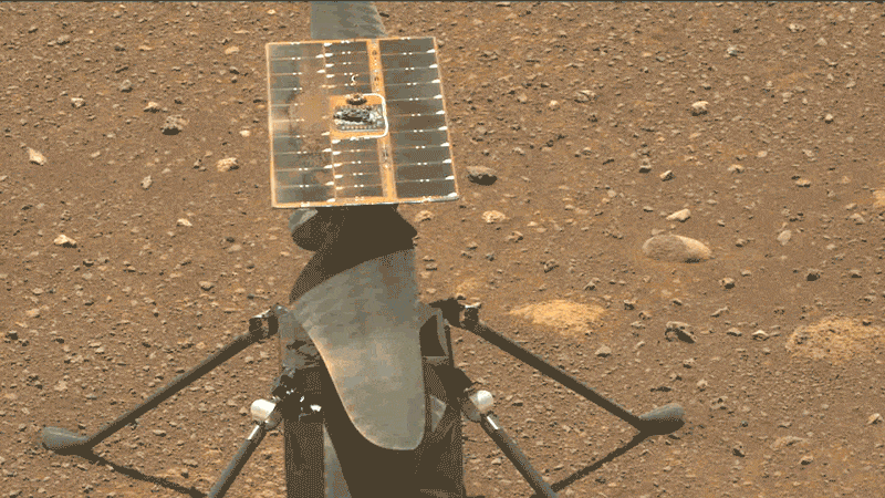
Integrity runs a “wiggle test” of its rotor blades prior to flight. (Photo: NASA/JPL-Caltech/ASU)
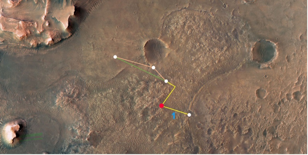
Ingenuity’s 21st flight is the first of at least three needed to transverse the Séítah region to reach its next base. From there, it will make flights to examine an old river delta. The whole relocation trip will cover about 1,150 feet as Integrity navigates around a large hill. While flying these investigative routes, the NASA team continues to gently push the drone’s capabilities to better understand improvements that can be applied to future Mars UAV designs.
Proposed route to reach river delta. (Image: NASA/JPL-Caltech/University of Arizona/USGS)
Once at the river delta, Ingenuity will encounter higher ground — up to 130 feet above the floor of the Jezero Crater, where it previously flew. The new area is expected to present significant obstacles: jagged cliffs, angled surfaces, rocky outcroppings and sand-filled traps. These obstacles could hamper the Perseverance rover or tip over the small drone on landing. But it’s also a place NASA thinks could harbor evidence of past life.
On arriving at the delta, Ingenuity’s first task will be to help decide which of two river channels Perseverance should take to climb to the delta. Data from the drone will also pick out science targets that Perseverance could investigate on the way. Once established in the delta region, NASA also hopes to fly Ingenuity to scout other features the rover might not be able to reach, but which might be accessible on future missions.
NASA has uploaded several upgrades to Ingenuity. They enabled higher, faster and longer flights and speed changes. The upgrades also have improved the drone’s perception of landing areas. Potential upgrades include adding terrain elevation maps and a hazard-avoidance capability for safer landing.
E-Scooters Adopt Pedestrian Defense
An outfit that rents e-scooters in more than 60 cities worldwide is adopting a “pedestrian defense” AI upgrade to prevent renters from abusing others around them and keep them riding within acceptable rules of operation.
LINK e-scooter. (Photo: Superpedestrian)
Previous efforts have only give riders visual and audio warnings that they should not enter a sidewalk. This new e-scooter active defense system slows the scooter to a stop and will not allow it to resume operation until it is moved outside the prohibited area.
Other unsafe behaviors — riding the wrong way up one-way streets, parking in the wrong place or aggressively swerving — also can be detected and actively deterred.
Sensors on the scooter provide data that relates location and activity to onboard stored city maps and geofenced areas. This enables application of enforcement commands within a second of them being detected.
The system provides cities and operators with visibility for the whole fleet of scooters. It shows what renters are doing within existing street safety restrictions, allowing both city and rental company officers to address perceived operational issues.