Tag: autonomous vehicles

  • Autonomous fighter drones join the front lines in USAF operations

    Autonomous fighter drones join the front lines in USAF operations

    The U.S. Air Force is increasingly referring to its next generation of unmanned aircraft as “fighter drones,” as the service prepares to integrate these vehicles alongside traditional fighter jets in combat missions. The Air Force’s Collaborative Combat Aircraft (CCA) program includes two separate vehicles under development by General Atomics Aeronautical Systems (GA-ASI) and Anduril, both designed to operate as combat-ready UAVs. These UAVs are being built to complement existing fighter fleets, providing additional capabilities and support during operations. According to Air Force officials, the new aircraft are expected to play a key role in future air combat by flying alongside piloted fighters and taking on a variety of tactical missions.

    One is an all-stealth design for undetected penetration of enemy defenses; the other is a sleek fighting companion.

    GA-ASI YFQ-42A fighter drone prototype (Credit: USAF)
    GA-ASI YFQ-42A fighter drone prototype (Credit: USAF)

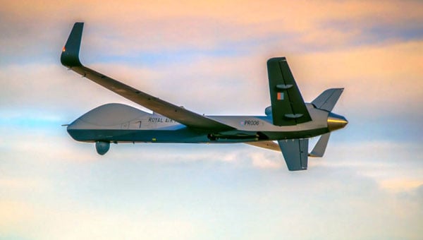
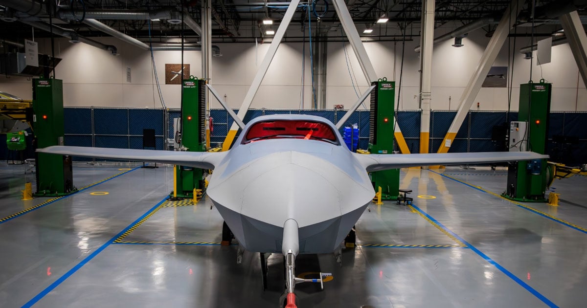
    It appears the General Atomics YFQ-42A/CCA drew inspiration from the earlier stealth capabilities of the Avenger UAV, which has been in flight for more than a decade. This aircraft has a maximum ceiling of over 50,000 ft, flies at 400 mph, has around 15 hours of endurance and is powered by a built-in turbofan engine.

    Avenger UAV (Credit: GA-ASI/Tyson Rininger)
    Avenger UAV (Credit: GA-ASI/Tyson Rininger)

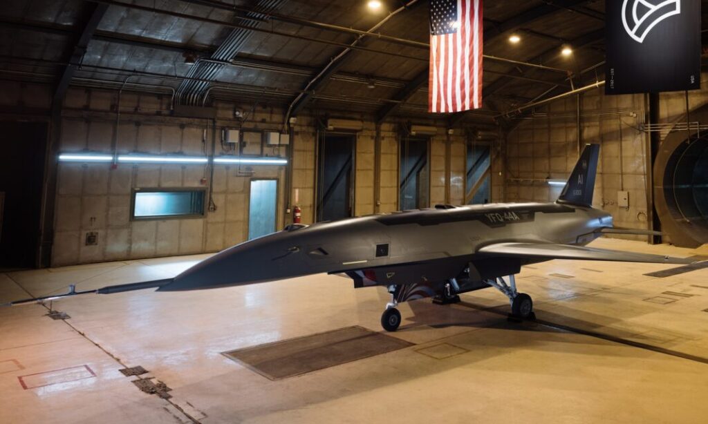
    One notable feature of the CCA version is its split, sloping “tailfin” and rounded design, along with a top fuselage air intake that shields the power plant from potential radar signals – all stealthy characteristics similar to those of its Avenger counterpart. Looking closely at the prototype, the doors on its belly appear to be for an internal weapons bay.

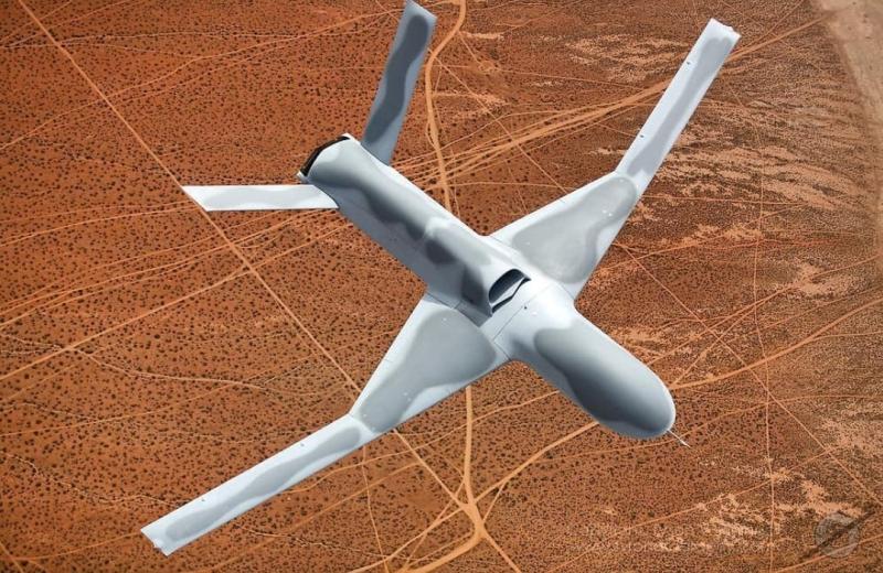
    Another USAF CCA prototype, built by Anduril, has been named the FYQ-44. It features a sleek and fast design, similar to earlier pre-stealth fighters, but also includes an internal weapons bay, rounded contours, and an air intake below the fuselage for a turbofan engine.

    Andruil YFQ-44 undergoes ground testing. (Credit: USAF)
    Anduril YFQ-44 undergoes ground testing. (Credit: USAF)

    The USAF’s release of these two CCA prototype contenders seems to suggest that they could be the fighter aircraft of the future. The CCA program, however, does talk about control of these armed UAVs by accompanying mainline manned fighter aircraft, but with autonomous capability to find and destroy once dispatched to attack a target.

    The intent is that these unmanned fighters will be significantly less costly to acquire than their expensive manned brothers so that high-risk targets may still be attacked and destroyed without potential loss of the flying pilot or their expensive aircraft. The unmanned fighters would be programmed by the manned aircraft and missiles in their internal weapons bay, would then go on to be controlled by onboard CCA weapons systems, which would relay data back continuously to the pilot who would have final go/no-go authority.

    Both prototypes are slated to fly later this year following extensive ground testing campaigns.


    After securing an initial $60 million contract from the USAF in 2021, Hermeus went on to raise $100 million in funding in 2022. This was followed by an investment from Raytheon Technologies’ RTX Ventures later that year. Additionally, the company landed a contract for Hypersonic risk reduction from the Defense Innovation Unit (DIU), allowing Hermeus to maintain its funding and momentum. This enabled the company to build and recently fly its first unmanned aircraft, which is designed to travel at extremely high speeds, according to the company.

    Hermeus Quarterhorse initial prototype UAV (Credit: Hermeus)
    Hermeus’ Quarterhorse initial prototype UAV (Credit: Hermeus)

    Initially, with an integrated GE J85 engine, Hermeus is now launching the incorporation of the Pratt & Whitney F-100 into its own “Chimera II turbine-based combined cycle (TBCC) propulsion system,” all aimed at taking subsequent iterations of their prototype to hypersonic speeds.

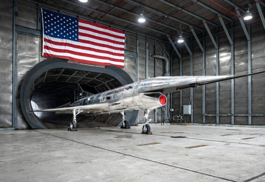
    Quaterhorse has been developed to demonstrate high-speed take-off and landing of a large unmanned aircraft, and is the first in a series of prototypes. And a couple of months ago, on May 27 at Edwards Air Force Base (AFB) in California, Quaterhorse did in fact take off, performed a short overhead circuit and landed! So, more flight tests are now expected to explore the drone’s flight characteristics.

    The TBCC two-phase engine with the Pratt F-100 front-end is slated to take Darkhorse, the next planned drone derivative, to Mach 2.8 on the F-100 and then up to over Mach 5 with the hypersonic back-end section of the engine. It could be said that the whole vehicle is being built around this monster engine!


    It will be interesting to see how flight testing of Quaterhorse progresses, but even more exciting to hopefully see if and when Hermeus gets the next hypersonic version flying. Additionally, we can anticipate the first flights of the USAF CCA prototypes.

    It is amazing how, from the humble beginnings of hobbyist radio-controlled recreational model aircraft, drones have evolved with sophisticated autopilots and are now becoming autonomous vehicles that are taking on front-line air force attack-support. Technological progress is now headed towards hypersonic capability.

  • DJI launches UAV for long-endurance aerial missions

    DJI launches UAV for long-endurance aerial missions

    DJI has unveiled the Matrice 400, designed for a range of applications, including emergency response, power line inspections, large-scale mapping, engineering and construction. The UAV offers a maximum flight time of 59 minutes and can carry payloads weighing up to 6 kg. It is equipped with a lidar and millimeter wave radar-based obstacle sensing system, enhancing its ability to navigate complex environments.

    The Matrice 400 features an IP55 protection rating, allowing it to operate in harsh conditions and withstand extreme temperatures ranging from minus 20°C to 50°C, according to DJI. The company also states that the drone is capable of taking off from stationary vessels and landing on moving ships, making it suitable for offshore operations such as wind turbine inspections and maritime patrols.

    The UAV offers power-line-level obstacle avoidance, which allows it to detect and avoid buildings and mountains while flying at speeds up to 25 m/s. It uses O4 Enterprise Enhanced Video Transmission technology, which supports image transmission up to 40 km. This is achieved through a 10-antenna system on the aircraft and a high-gain phased array antenna on the remote controller. A built-in video transmission relay module allows operators to use one Matrice 400 as a relay drone, providing signal support for another unit.

    The drone is designed for automated operations, featuring multiple intelligent functions to improve efficiency. It supports up to seven payloads simultaneously through four external E-Port V2 ports, with options for single or dual downward gimbals and compatibility with a third gimbal connector on the underside. DJI has also incorporated a range of privacy controls to address the data security needs of enterprise users.

    Photo:
    DJI Matrice 400 drone platform (Credit: DJI)
  • UAV companies discuss FAA BVLOS policy at White House

    UAV companies discuss FAA BVLOS policy at White House

    Representatives from 18 drone technology companies — including AgEagle Aerial Systems, uAvionix, BRINC, Kelly Hills and Pierce Aerospace — participated in a second high-level, invitation-only policy discussion with the White House, hosted by the Office of Information and Regulatory Affairs (OIRA). This most recent engagement was centered on the proposed FAA Rule Part 108, which will define the regulatory framework for beyond visual line of sight (BVLOS) drone operations across the United States.

    The finalization of FAA Rule Part 108 is expected to replace the current piecemeal waiver-based system, providing a more predictable, scalable, and innovation-friendly regulatory environment.

    Enactment of Part 108 would remove operational barriers, drive capital investment, and unlock next-generation drone technologies that enhance both commercial and public sector applications, explained AgEagle CEO Bill Irby.

    “This follow-up invitation by OIRA reaffirms the strategic importance of expanding BVLOS operations for the domestic drone industry,” Irby said. “Thoughtful and timely rulemaking can accelerate innovation, improve safety and compliance, and strengthen the U.S. position as a global leader in drone technology. Of particular value was the discussion of how streamlined regulation will allow broader deployment of autonomous data solutions and open the door for increased economic activity.”

    The engagement was made possible in part through the leadership and coordination of the Association for Uncrewed Vehicle Systems International (AUVSI) and the Commercial Drone Alliance (CDA), who played key roles in facilitating industry participation and ensuring productive dialogue between the private sector and federal stakeholders.

  • Low-cost antennas power high-precision space-based positioning

    Low-cost antennas power high-precision space-based positioning

    A novel method using signals of opportunity from low-Earth orbit (LEO) satellites is redefining what’s possible in satellite-based navigation. Researchers have developed a joint pseudo-range and Doppler positioning technique that taps into signals from constellations like Starlink and Iridium NEXT — without relying on traditional navigation signal structures.

    By employing low-cost, wide-beam antennas and a specially designed time–frequency inversion algorithm, the team achieved remarkable accuracy: 3.6 meters in 2D and 6.2 meters in 3D, surpassing Starlink positioning approaches based on parabolic antennas by 35%.

    Technical barriers in using signals of opportunity include signal transmission times, low signal power, and imprecise orbital data, all of which hinder accurate positioning. Addressing these challenges demands a new approach to extracting usable navigation data from LEO constellations.

    In response, researchers from the Aerospace Information Research Institute introduced a joint pseudo-range and Doppler positioning method using wide-beam antennas to receive LEO satellite SOPs. The approach centers on a signal time–frequency inversion algorithm that reconstructs key signal parameters, alongside a novel accuracy metric called Equivalent Position Dilution of Precision (EPDOP).

    Real-world experiments combining Starlink Doppler data and Iridium NEXT pseudo-range signals confirmed strong performance, especially in long-baseline conditions — reinforcing the method’s global applicability.

    To overcome the cost and complexity of existing satellite tracking equipment, the team employed low-noise bock (LNB) wide-beam antennas capable of simultaneously receiving signals from multiple Starlink satellites. The core innovation lies in a signal processing algorithm that estimates transmission time and frequency from the received code phase and Doppler shifts — enabling both pseudo-range and Doppler observations without needing exact satellite clock data or real-time ephemeris.

    To quantify system performance under real-world errors, the researchers developed the EPDOP metric, adapted to mixed measurement inputs. Tests demonstrated the method’s robustness: 3.6 m 2D and 6.2 m 3D positioning using Starlink Doppler signals, and up to 24 m (2D) and 41 m (3D) accuracy using Iridium NEXT SOPs over a 40 km baseline. Compared to Doppler positioning techniques, the algorithm reduced positioning errors by over one-third and successfully suppressed the impact of orbital inaccuracies inherent in public two-line element set (TLE) datasets.

    “This work marks a key step toward accessible, accurate navigation using commercial satellite constellations,” said lead author Ying Xu. “By integrating Doppler and pseudo-range measurements and introducing a flexible precision metric, we can now harness Starlink and Iridium NEXT signals for high-precision positioning, even without access to proprietary signal structures. The proposed low-cost architecture opens new possibilities for resilient navigation in GPS-denied environments.”

    Because of its ability to operate with low-cost antennas and weak, unstructured signals, the technique is poised to support a wide range of applications: from autonomous driving and unmanned aerial vehicle (UAV) navigation in remote regions to emergency response and IoT asset tracking. Its resilience to satellite orbital prediction errors and adaptability across different LEO constellations make it a strong contender for next-generation positioning systems. As LEO deployments continue to expand globally, this approach offers a scalable and practical solution for real-time, high-accuracy navigation—promising enhanced capabilities for both civilian infrastructure and defense operations.

    The researchers’ study is published in Satellite Navigation (DOI: 10.1186/s43020-025-00163-y).

    Signal acquisition of Iridium NEXT satellites’ signal in the long baseline positioning scenario. (Credit: Aerospace Information Research Institute)

  • Drones at War: Ukraine’s bold attack shows future warfare era

    Drones at War: Ukraine’s bold attack shows future warfare era

    On June 1, 117 drones rose up from wooden boxes inside Russia and attacked bombers parked on runways at military bases. The attack — dubbed Operation Spider Web — startled the world with its audacity.

    Approximately 41 planes were struck at four military bases, including the Belaya Air Base in Siberia hundreds of miles from Ukraine’s borders. In all, the attack destroyed a third of the bombers Russia uses as strategic cruise-missile carriers to destroy targets in Ukraine.

    The drones were smuggled into Russia via commercial trucking transportation.

    According to an analysis by Michael C. Horowitz for the Council on Foreign Relations, the strikes “once again demonstrated Ukraine’s ability to be at the cutting edge of technology and tactics. Ukraine has consistently and successfully leveraged and integrated everything from old military technology and off-the-shelf commercial systems to artificial intelligence (AI) for its military operations. This has been a difference maker in the war since its early days, giving Ukraine new and unexpected vectors to attack Russian forces and territory.”

    The analysis, by Michael C. Horowitz, calls this a new era for warfare — the era of precise mass. “The combination of AI and autonomous weapons, precision guidance, and commercial manufacturing mean that low-cost precision strikes are now accessible to almost any state or militant group,” Horowitz writes.

    Horowitz described the era of precise mass in a feature in Foreign Affairs magazine, November/December 2024.

    The attack demonstrates that countries can be at risk to drone attacks even deep inside its borders, and precision strikes the capability of any actor. Low-cost off-the-shelf drones can be readily used, along with open-source autopilot software and AI code. Drones can supplement or even replace traditional artillery or expensive cruise missiles.

    Read the full analysis here.

  • 3D scan of Titanic reveals new details of shipwreck

    3D scan of Titanic reveals new details of shipwreck

    In 2022, deep-sea mapping company Magellan undertook the largest underwater 3D scanning project of its kind to create the first full-size digital scan of the Titanic. The luxury passenger liner sank in the North Atlantic Ocean on April 15, 1912, after striking an iceberg, and now rests 12,500 ft below the surface.

    Over three weeks, the Magellan team worked around the clock to capture the luxury vessel in unparalleled detail. They used two remotely operated vehicles (ROVs) — dubbed Romeo and Juliet — to systematically canvass the site. In total, the ROVs collected 715,000 photos, 4K footage and millions of laser measurements — a total of 16 terabytes of data.

    The scan itself was only the beginning. The Magellan team then processed the collected data into a smooth, comprehensive 3D point cloud. Applying new processing techniques to the original Magellan IP and raw data sets provided a new data set with 35% better resolution and accuracy. Each point in the dense point cloud used to generate the model has its unique set of Cartesian coordinates(X,Y, Z), time stamp and texture.

    A National Geographic documentary
about the project, “Titanic: The Digital
Resurrection,” is now streaming on
Disney+ and Hulu. The 90-minute
documentary was produced by Atlantic
Productions for National Geographic. (Photo: Magellan Limited/Atlantic Productions)
    A National Geographic documentary about the project, “Titanic: The Digital Resurrection,” is now streaming on Disney+ and Hulu. The 90-minute documentary was produced by Atlantic Productions for National Geographic. (Photo: Magellan Limited/Atlantic Productions)

    Titanic analyst Parks Stephenson has visited the actual Titanic wreck twice, but the virtual scan revealed
    details he never saw before. Aboard a submersible, with its six-inch viewport and limited camera views, details are easily missed. “It’s like being in a dark room and you have a flashlight that’s not very
    powerful,” Stephenson told National Geographic. The digital twin gave him an unobstructed, 360° view of every nook and cranny.

    The digital twin reconstructs Titanic’s structural collapse in forensic detail. A video rendering of it can be projected to life-size in a warehouse, allowing experts to walk through its final moments. For instance, an open steam valve in the boiler room validates eyewitness accounts that the ship’s engineers remained at their posts for more than two hours after impact, keeping the electricity on and allowing wireless distress signals to be sent. The 35 men may have saved hundreds of lives while sacrificing their own.

    Photo: Magellan Limited/Atlantic Productions
    Photo: Magellan Limited/Atlantic Productions

    The digital scan also helps exonerate First Officer Murdoch, long accused of abandoning his post. The position of a lifeboat davit suggests his crew was preparing a launch moments before the starboard side was engulfed, corroborating Second Officer Charles Lightoller’s testimony that Murdoch was swept away by the sea.

    The scans reveal the wreck’s alarming deterioration, with iconic areas collapsing. But the mapping project means the ship is now digitally preserved, along with similar models of historic sites around the world.

    Magellan has launched an app built on
the Titanic’s scans, available in Early
Access on the Steam platform. “vROVpilot:
TITANIC” puts users in the pilot seat of
a virtual ROV to explore the wreck and
complete missions to scan its key features.
The experience comprises an accurate
ROV user interface, along with realistic
underwater condition visual effects and
comprehensive sound effects, according to
the developer.
So far, the app is using only the data
on the bow, which is less than 35% of the
full data set. The stern is expected to be
added next, followed by the 15-squaremile debris field, which shows personal
effects such as pocket watches, purses,
gold coins, hair combs, shoes and a
Megalodon-tooth necklace.
    Magellan has launched an app built on
    the Titanic’s scans, available in Early
    Access on the Steam platform. “vROVpilot:
    TITANIC” puts users in the pilot seat of
    a virtual ROV to explore the wreck and
    complete missions to scan its key features.
    The experience comprises an accurate
    ROV user interface, along with realistic
    underwater condition visual effects and
    comprehensive sound effects, according to
    the developer.
    So far, the app is using only the data
    on the bow, which is less than 35% of the
    full data set. The stern is expected to be
    added next, followed by the 15-squaremile debris field, which shows personal
    effects such as pocket watches, purses,
    gold coins, hair combs, shoes and a
    Megalodon-tooth necklace. (Photo: Magellan Limited/Atlantic Productions)
  • oneNav debuts L5-direct ASIC receiver with advanced jamming resilience

    oneNav debuts L5-direct ASIC receiver with advanced jamming resilience

    oneNav has developed an L5-direct GNSS receiver ASIC, a breakthrough that enables devices to directly acquire and track L5-band satellite signals without relying on the older, more vulnerable L1 signals. The L5-direct receiver was rapidly designed and brought to market using the GlobalFoundries 22-nanometer FDX platform, which offers advanced mixed-signal integration and ultra-low power performance for both radio frequency and digital functions.

    The new receiver features a unique processor architecture, described as a “GPU for GNSS,” that eliminates dependence on L1 signals. This approach is designed to address critical vulnerabilities in aviation, defense and consumer navigation applications, where L1 signals are increasingly susceptible to jamming and spoofing. According to oneNav, the L5-direct technology is completely immune to L1 jamming and offers six to seven times greater resilience to interference and jamming in the L5 band compared to legacy solutions. It also delivers a tenfold improvement in measurement precision, faster initial location acquisition, enhanced accuracy in dense urban environments and reduced power consumption compared to L1-dependent receivers.

    L5-direct can be deployed across defense, national security, industrial and consumer markets, offering a significant boost in jamming resistance for GPS-based positioning and timing applications.

    “The need for ultra-low power consumption with high jamming resilience is acute in the rapidly growing unmanned vehicle segment, including drones,” said oneNav CEO Steve Poizner.

    Earlier this year, oneNav partnered with three military agencies to evaluate L5-direct in terrestrial, maritime and aerial environments under simulated electronic warfare conditions. The trials confirmed the technology’s immunity to L1 interference and demonstrated its superior resilience to L5 jamming.

    Key features of the GlobalFoundries 22FDX+ platform that enabled this innovation include optimized power-performance balance, advanced mixed-signal integration, ultra-low power consumption and enhanced RF performance, supporting a wide range of applications.

    The L5-direct technology is now available as licensable intellectual property and can be customized for use in a range of applications, from consumer wearables to unmanned aerial vehicles. It can also complement military-grade M-Code solutions for applications requiring high resilience, low power and rapid signal acquisition.

  • India’s UAV progress threatened by GNSS jamming; infiniDome offers solutions

    India’s UAV progress threatened by GNSS jamming; infiniDome offers solutions

    India continues to make significant progress in developing indigenous unmanned aerial vehicles, loitering munitions and autonomous systems. However, many of these platforms face a critical vulnerability: their reliance on unprotected satellite navigation. This threat is no longer theoretical.

    Recent escalations with Pakistan, including drone incursions, cyber operations and suspected GPS interference near sensitive border areas, have underscored the growing use of low-cost, easily concealed GNSS jamming tools. Such devices can disrupt UAV operations, sever navigation links and compromise mission success, regardless of how sophisticated the system may be.

    Without robust GNSS protection, even the most advanced unmanned systems are at risk of operational failure, loss of control and diminished national security capabilities.

    One countermeasure comes from infiniDome, a global provider of GNSS protection technology. The company develops lightweight, easily integrable anti-jamming solutions that are already deployed by leading defense forces to ensure continuous operation in contested electromagnetic environments.

    InfiniDome has extensive operational experience in active conflict zones and a strategic focus on compact, cost-effective systems. These solutions are well suited to India’s growing demand for scalable, lightweight UAVs and autonomous platforms, according to the company.

  • 2025 NASAO Conference

    2025 NASAO Conference

    The National Association of State Aviation Officials provides opportunities for those engaged in aviation and unmanned aerial vehicles.

    NASAO’s Annual Convention & Trade Show provides a space for state aviation directors and their staff to connect, collaborate, and become inspired. Not only does the annual convention provide hundreds of attendees with engaging sessions and demonstrations, it also gives them the chance to experience the state like a local.

    The 2025 conference will take place in Grand Forks, North Dakota, Sept. 21-24, at the Dena’ina Civic and Convention Center.

  • UAV updates: Approval milestones, new eVOTLs and autonomous warfare

    UAV updates: Approval milestones, new eVOTLs and autonomous warfare

    For anyone out there who has ever worked through a formal process of equipment development for subsequent FAA/military or other national certification, you would likely appreciate the significance of a UAV approval milestone.

    General Atomics (GA-ASI) has just provided notice that the Royal Air Force (RAF) Protector RG Mk1 — based on the MQ-9A Reaper unmanned aircraft system (UAS) — has been granted a Military Type Certificate, having demonstrated compliance based on the requirements of STANAG 4671, NATO’s UAS airworthiness standard.

    RAF Protector RG Mk-1 (Photo: GA-ASI)
    RAF Protector RG Mk-1 (Photo: GA-ASI)

    This is big news for the RAF and GA-ASI, which enables this large Class III UAS to fly almost anywhere, without restricting flight over cities and other densely populated areas, and most importantly, facilitating flight within civil airspace. New capabilities that have been added include lightning and fire protection, as well as anti-icing systems. The strong airframe is designed to withstand long-term operational stress and exhibit a level of resilience against the effects of multiple airborne combat missions.

    The software and electronic hardware were developed in accordance with current industry standards, which are intended to ensure the safety and reliability of systems. However, overall, GA-ASI has invested more than half a million dollars of its own money over 11 years to achieve this approval. Extensive environmental testing included lengthy, complex static and dynamic load tests, and extensive simulations were undertaken to verify performance over the operating envelope of the aircraft.

    If you have ever seen a static ground test rig for stressing and even over-stressing an airframe, the significant number of hydraulic jacks within a massive steel girder enclosure is something to behold. Just building the structure and tuning the electronic systems which drive it, and fixing things on the rig and the airframe as tests progress over many months this is a significant undertaking and investment.  

    The RAF has so far taken delivery of 11 of the 16 Protector UAS under order, and this certification is a major milestone on the way toward operational deployment. For General Atomics, this initiative hopes to not only lead to further military organizations purchasing an MTC-qualified UAS but also to open the door for civilian qualification options.


    In the meantime, Joby Aviation in Santa Cruz, California, has just achieved a major milestone on the way to civil certification of its electric Vertical Take Off and Landing (eVTOL) passenger aircraft. With orders and sponsorship from Delta, Toyota, Uber and many others, the company is working toward piloted and autonomous flying taxis.

    Joby’s eVTOL piloted transition from vertical to horizontal (Photo: Joby)
    Joby’s eVTOL piloted transition from vertical to horizontal (Photo: Joby)

    The major event involved an onboard pilot flying the eVTOL from a vertical takeoff through the transition to horizontal, wing-borne flight. This clears a major hurdle along the path to civil certification, enabling FAA pilots to be on board to monitor operations and fly the eVTOL.

    The Joby test pilot first flew this production aircraft on April 22, with all the propellers horizontal and lifted off to about 30ft, just as a helicopter would take off. After a brief pause, the engine nacelles were rotated gradually forward and the eVTOL slowly crept forward. Traveling approximately 500 yards, the transition to wing-borne flight occurred as speed increased, and eventually, the climb-out began.

    After several repetitions with two other test pilots, the piloted transition process was considered ready for operations and the next chapter was on the way to initial validation testing and air-taxi operations, which will be in Dubai.

    Since 2017, Joby has flown a number of its eVTOL aircraft for a total of over 40,000 flight hours, with ground-pilot control, and with an onboard pilot in hover and forward flight. However, the transition phase has never been flown with an onboard pilot in full control. So that means presumably that all previous transitions had been controlled externally from the ground. This puts Joby well on the road to certification — other eVTOL manufacturers have made crewed transitions, but with separate propellers for lift and for forward flight – this is the first with one set of tilting propellers which is a principle operational feature of the Joby eVTOL.


    AeroVironment (AV) supplies a wide variety of UAS to the U.S. and other militaries. Nevertheless, the company has recently released information about a new one-way drone, which features enhanced capabilities, bringing forward “new, innovative solutions and improvements,” according to the release. This latest contender is apparently equipped to accept software upgrades throughout its design lifetime to continuously add more capabilities and specializations.

    The Red Dragon UAV differs in that it is claimed to be fully autonomous (when circumstances require it) and can navigate in GPS-denied environments.

     Red Dragon UAV illustration (Image: AV)
    Red Dragon UAV illustration (Image: AV)

    Given that modern battlefields are an electronic nightmare for GNSS navigation and control/data channels, AV has endowed Red Dragon with a hardened GPS baseline system, augmented by visual navigation, digital scene matching and automatic target recognition, and also using airspeed and laser rangefinder inputs. When necessary, the UAV can continue to track its target without requiring satellite control signals. There is a return link back to the operator, but when that link goes down, Red could proceed alone, or optionally crash-land if targeting doesn’t meet pre-programmed parameters.

    Carrying a 5lb charge, Red is not designed to return to its owner, rather to deliver a penetrating destructive explosion. Even if doesn’t self-destruct, no-one wants this package back, its completely disposable. With a 250-mile range flying at 50 mph to 60 mph, the UAV can accelerate at up to 100 mph in the final phase of its attack.

    Built simply for ready use in the field and to greatly reduce unit volume manufacturing cost, this new one-way munition may be the result of lessons learned during recent battles – possibly just what forces think they need through the use of already combat-proven attack drones such as the AV Puma and Switchblade. It is reported that Red Dragon may have already experienced actual combat.


    To recap, General Atomics’ most recent Reaper variant is now ready to fly almost anywhere with its very own UK MTC certification, Joby’s tilt-rotor eVTOL has cleared the piloted transition hurdle and AeroVironment has released a new kind of loitering munition with autonomy and GPS-denied navigation capability — both military and civilian UAVs at the forefront of unmanned evolution.

  • Septentrio launches various ultra-compact GNSS receiver models

    Septentrio launches various ultra-compact GNSS receiver models

    Septentrio, part of Hexagon, has introduced the mosaic-G5 series, expanding its line of compact GNSS receiver modules. The mosaic-G5 modules offer a 60% reduction in size and a 40% decrease in power consumption compared to the earlier mosaic-X5 receiver. The new modules measure 23 mm x 16 mm and weigh as little as 2.2 g, making them suitable for applications where size, weight and power are critical considerations, such as commercial UAVs, robotics and high-volume industrial equipment.

    The mosaic-G5 modules offer reliable, high-accuracy positioning even in environments where GNSS signals may be degraded or obstructed. The mosaic-G5 product line includes several variants tailored to different use cases. The triple-band mosaic-G5 P1 is designed for high-volume applications, such as inspection drones and robotic mowers. The quad-band mosaic-G5 P3 and the triple-band heading module mosaic-G5 P3H offer enhanced positioning reliability in challenging conditions and are suited for applications such as delivery UAVs and light show UAVs. The P3H variant can calculate heading with a minimal baseline between two GNSS antennas, enabling accurate navigation for small autonomous device.

    The new modules complement the mosaic product line, where the mosaic-X5 receiver remains as the benchmark for world-leading GNSS open signal anti-jamming and anti-spoofing resilience in a small form factor.

    The mosaic-G5 modules complement Septentrio’s broader mosaic portfolio, which is recognized for its all-band GNSS technology, accuracy, reliability, and resilience to jamming and spoofing. The established mosaic-X5 receiver remains a benchmark for anti-jamming and anti-spoofing performance in a compact form factor. Like the mosaic-X5, the new modules are compatible with widely used open-source autopilots, such as PX4 and ArduPilot, simplifying integration and reducing development time. An evaluation kit, mosaic-go G5, is available to facilitate testing, and the RxTools user interface is provided for setup and evaluation.

    Samples of the new mosaic-G5 P1, mosaic-G5 P3, and mosaic-G5 P3H modules are now available, with volume orders available for delivery later this year.

    mosaic-G5 go (Photo: Septentrio)
    mosaic-G5 go (Photo: Septentrio)
  • Vatn Systems unveils new AUV-torpedo product line and manufacturing facility

    Vatn Systems unveils new AUV-torpedo product line and manufacturing facility

    Vatn Systems — a defense technology company specializing in autonomous underwater vehicles (AUVs) for the U.S. military, its allies and commercial clients — has launched its new S12 AUV-torpedo product line. The company also opened a new manufacturing facility in Rhode Island, which is capable of producing up to 2,000 vehicles annually.

    AUV-torpedo product line

    Vatn Systems’ new 12.75-inch diameter AUV can operate as both a torpedo and an AUV in modular configurations. The Skelmir S12 is designed for deployment from submarines, surface vessels, or aircraft, and can support a range of missions, including torpedo operations, sensor delivery and electronic warfare.

    The Skelmir S12, in its AUV configuration, has completed its first exercise. The initial production run has been sold to government customers, with deliveries expected this year. The torpedo variant is scheduled for manufacturing and delivery in 2026.

    A video of the AUV can be found here.

    New manufacturing facility scales production

    The company’s new manufacturing facility leverages patent-pending modular design and vertical integration techniques, enabling rapid production at a scale previously unseen in the underwater vehicle market.

    Vatn recently partnered with Palantir to digitize its manufacturing process and provide AI-driven insights to accelerate the production of AUVs built in the new facility, which is expected to reach full production capability in July 2025.