Tag: autonomous vehicles

  • Helicopter and space UAVs pave the way for autonomous systems

    Helicopter and space UAVs pave the way for autonomous systems

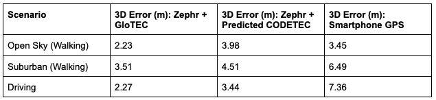
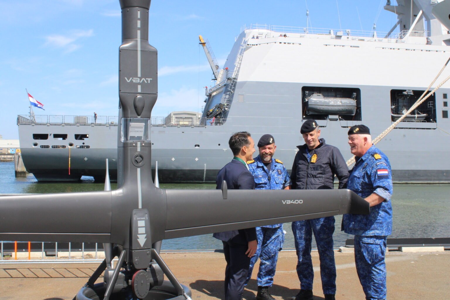
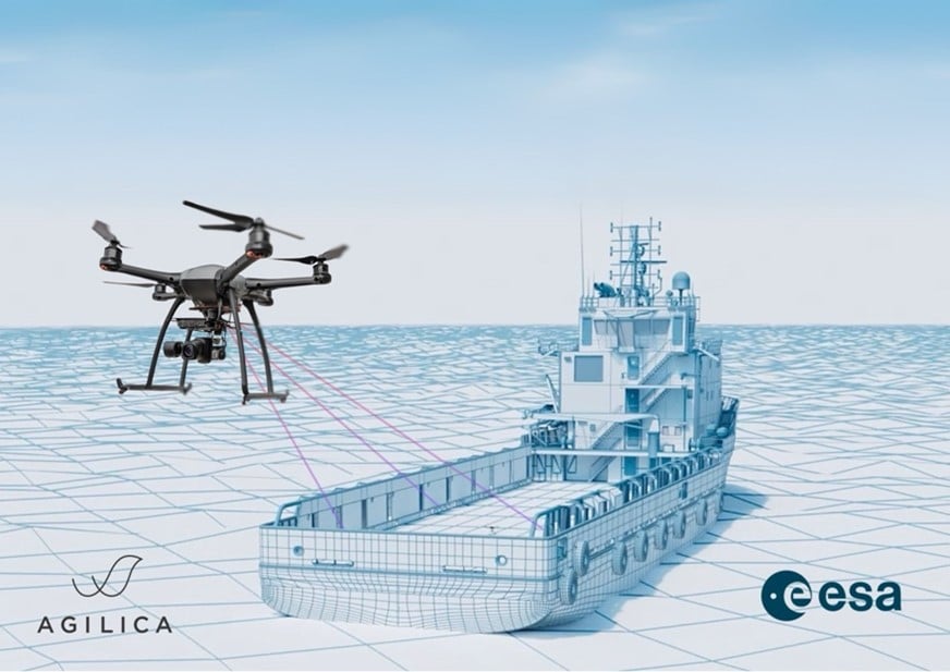
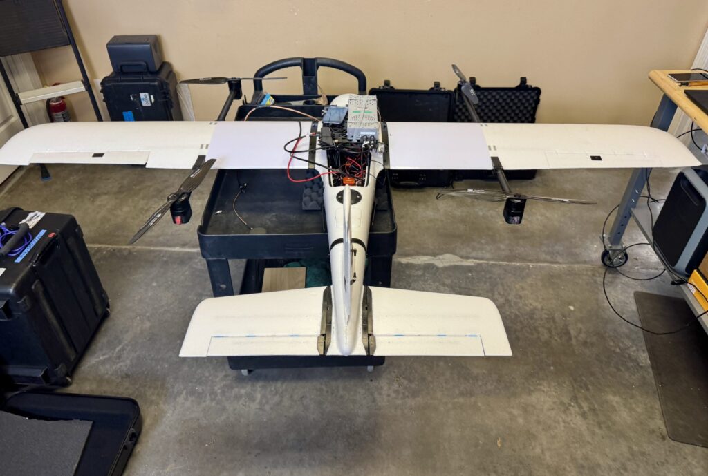
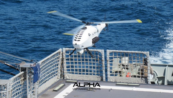
    Alpha Unmanned Systems (Alpha) in Madrid, Spain, has been developing and building helicopter UAVs for 10 years and has successfully employed them with defense departments in 10 countries. Its UAVs are ruggedized and qualified for the harsh conditions encountered at sea. The fully autonomous A800 and more recent A900 model UAVs have been used in military applications such as border patrol, situation awareness, intelligence gathering, coast guard support and aerial helicopter target simulation. Commercial applications include fishing fleets and oil rig support.

    Alpha A900 approaches for deck landing. (Credit: Alpha)
    Alpha A900 approaches for deck landing. (Credit: Alpha)

    The helicopter UAVs are equipped with a GNSS/MEMS autopilot system that maintains navigation if GNSS is jammed. MEMS sensors, however, can experience significant drift over time. The Alpha model offers two additional backup solutions. With an advanced air data system and pitot sensors, the aircraft can estimate airspeed and wind velocity to help maintain its flight path. If attitude estimation degrades further, remote pilot judgment may be required to recover control. For ground operations, a visual navigation system with a downward-looking camera can record terrain during overflights, building a database that enables navigation in GNSS-denied environments.

    One of the newer capabilities Alpha has added includes an Automatic Identification System (AIS) receiver. AIS is a primary radar transponder system used by ships around the world to provide each other with tracking information on other ships that are within about a 30-mile range. With an AIS receiver onboard the UAS surveillance helicopter, ships that are out of visual range, maybe out close to the horizon, now become trackable.

    Alpha is a small company that has been in operation since 2014, and it is one of the first to design helicopter UAVs for rough weather and at-sea environments. It’s good to see a focused, supportive outfit gradually succeed, not only with European defense organizations, but also in the U.S. and around the world.


    Meanwhile, in a universe that’s not far, far away — in fact, in our solar system — plans are moving forward at NASA to visit Titan with a UAV. Titan is a moon of Saturn that is most favored to have the capability to start, and maybe support, life. Numerous organic compounds have been detected during earlier satellite visits. But this is no ordinary UAV, quite unlike Ingenuity, the solar-powered hopper that NASA flew 72 times on Mars.

    Ingenuity, a UAV that flew 72 times on Mars. (Credit: NASA)
    Ingenuity, a UAV that flew 72 times on Mars. (Credit: NASA)

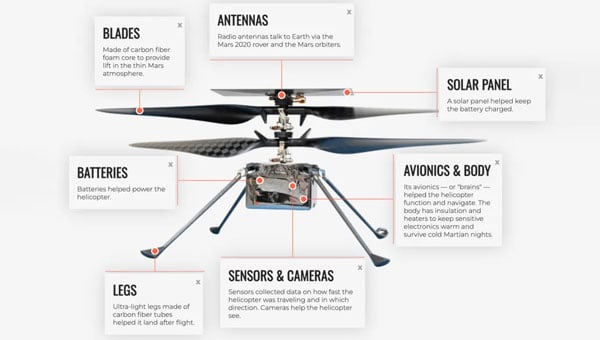
    NASA’s Ingenuity helicopter, which traveled to Mars attached to the Perseverance rover, was designed to demonstrate powered flight in the Red Planet’s thin atmosphere. Ingenuity featured oversized rotor blades to generate enough lift and was built to be as lightweight as possible. Its only equipment was a camera and speed sensors, with no scientific instruments aboard.

    The helicopter performed flights over Jezero Crater, ultimately spending about 130 minutes aloft and covering 11 miles during 72 flights. Ingenuity’s mission came to an end after it sustained damage to a rotor during a hard landing, grounding the aircraft and concluding its operations on Mars.

    The next interplanetary unmanned flying system is significantly more complex, replacing the lander and drone approach used on the Red Planet with a complete vehicle capable of flying and conducting the necessary investigative science. With a budget of $3.35 billion, NASA’s work has been underway since 2024, led by John Hopkins Applied Physics Lab, and a host of main and supporting organizations, including Lockheed Martin Space, Malin Space Science Systems (cameras), Honeybee Robotics (Blue Origin subsidiary, moon lander development) and participation by agencies in France, Germany and Japan. While Ingenuity was developed and built by UAV manufacturer AeroVironment with management/support from NASA/Jet Propulsion Labs (JPL), the team for Dragonfly appears to have a few industrial partners and extensive government support – hopefully, this works out!

    Powered by a Radioisotope Thermoelectric Generator (RTG), Dragonfly has four sets of double rotors, landing skids, and, of course, has to be fully autonomous – the radio transit time between Titan and Earth is between 1 hour 10 minutes and 1 hour 40 minutes. Titan’s night is eight Earth days long, so the idea is to fly during the day (throughout 15 Earth days), then land and recharge batteries, and receive NASA’s instructions for the following day’s activities during the long night. The atmosphere is thought to be substantially composed of nitrogen and methane, four times thicker than Earth’s, and gravity is about 1/7, so 4 ft props with enough lift and power could carry the 880 lb to 990 lb UAV up to 10 miles for each flight at altitudes of up to 12,000 ft. But when observing and imaging the terrain, we might guess it would probably mean mostly low-level flights.

    Dragonfly Titan UAV explorer (Credit: NASA/Johns Hopkins APL/Steve Gribben)
    Dragonfly Titan UAV explorer (Credit: NASA/Johns Hopkins APL/Steve Gribben)

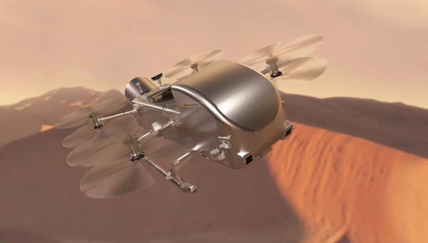
    At this weight, we are looking at something quite substantial to be flying around the anticipated sand dunes and frozen methane surface of Titan. Autonomous operations will need to be tight and safe for this big vehicle to operate and survive; it’s not exactly a small car, but quite substantial. Not to mention that landing will need to be somewhat delicate to protect the sensitive onboard instrumentation. 

    A spacecraft is scheduled to launch aboard a SpaceX Falcon Heavy in 2028, embarking on a complex journey that includes a flyby of Venus and a gravity-assist maneuver past Earth to set a direct course for Saturn’s moon Titan. The probe is set to enter Titan’s dense atmosphere directly, protected by a heat shield. After initial deceleration from atmospheric drag, two drogue parachutes will deploy, followed by a powered descent to the equatorial region known as the Shangri-La dune fields.

    The voyage is expected to take six years, with arrival at Titan in 2038. Once on the surface, the Dragonfly mission will begin a 2.7-year exploration of the moon.


    An interesting initial glimpse into a future, really advanced drone are undertaking. Hopefully, NASA will keep to its schedule, the budget holds up, and we start to see hardware in the next few years. Meanwhile, Alpha could be on version 16 of its UAV helicopter by then and achieve massive success with its multi-mission UAV applications.

  • Nowcasting the ionosphere: Evaluating GloTEC for real-time GNSS corrections

    Nowcasting the ionosphere: Evaluating GloTEC for real-time GNSS corrections

    One of the most persistent sources of GNSS error — ionospheric delay — has been challenging to correct in real time, especially for mass-market devices. While dual-frequency receivers and commercial correction services can mostly mitigate this issue, they remain too costly and impractical for the billions of smartphones and IoT devices that rely on single-frequency GNSS. Even for dual-frequency systems, the commonly used ionosphere-free linear combination amplifies multipath and receiver errors and reduces data redundancy — yielding only two usable combinations from four original measurements.

    This landscape may be shifting with the introduction of GloTEC, a real-time global Total Electron Content (TEC) map from NOAA’s Space Weather Prediction Center (SWPC), released in February 2025. GloTEC assimilates both ground- and space-based observations to provide real-time global ionospheric corrections without relying on error-prone linear combinations.

    Unlike coarse models such as the broadcast Klobuchar algorithm or forecast-only products such as the predicted IGS Global Ionosphere Maps, GloTEC updates every 10 minutes using real-time measurements. This high refresh rate establishes a new benchmark for open-access ionospheric nowcasting in GNSS applications.

    Originally designed to monitor and mitigate space weather impacts on aviation and communications, GloTEC may also deliver a broader benefit: enabling precise, scalable GNSS corrections for low-cost, single-frequency devices, making high-accuracy positioning more accessible and democratic.

    Why Nowcasting Matters for GNSS

    The GNSS community has long had to choose between accuracy and latency. Predictive models, such as those from NASA CEDIS or CODETEC, can offer reasonable approximations but may fall short when real-time corrections are required, particularly in the context of navigation, asset tracking or autonomous systems.

    Post-processed products (such as rapid/final IGS GIMs) provide excellent fidelity but are typically delayed by hours, days, or even weeks. This makes them useful for research or auditing, but not for real-time navigation needs.

    Commercial correction services, such as Trimble RTX and Hexagon’s TerraStar, have filled the gap for high-value applications. These systems interpolate ionospheric corrections in real time, but at a significant cost and they typically require specialized GNSS receivers.

    GloTEC bridges this gap by delivering a publicly accessible, high-refresh ionospheric product that can support near real-time corrections. Updated every 10 minutes with a 2.5° latitude and 5° longitude spatial resolution, GloTEC represents a major step forward for public sector GNSS capability, particularly in contexts where accuracy, reliability and scale are all crucial. The data has also been supporting the United States Space Force and is accessible through their Unified Data Library (UDL).

    Technical Approach: Adapting GloTEC for Practical Use

    While the potential of GloTEC is exciting, turning it into usable corrections for consumer-grade devices isn’t straightforward. TEC maps represent volumetric electron density, while most mass-market GNSS chipsets, especially in smartphones, expect simplified models, such as the eight-parameter Klobuchar model broadcast by GPS satellites. GloTEC is a three-dimensional data assimilation system that uses a Gauss-Markov Kalman Filter to estimate electron density in the ionosphere. It ingests slant TEC measurements from ground-based GNSS receivers and space-based radio occultation data, using the IRI-2016 model as its background state.

    To bridge this mismatch, Zephr’s team has been exploring regional fitting techniques, whereby a local subset of GloTEC data is used to generate custom Klobuchar coefficients. These can be transmitted to devices via standardized protocols, such as the LTE Positioning Protocol (LPP), enabling improved ionospheric delay estimation with minimal changes to device-side computation. Even with a regionalized Klobuchar fit and LPP encoding, there is still the problem of accessing the GNSS chip to apply the corrections. To solve this problem, Zephr has created a virtualized positioning engine that takes the raw GNSS measurements from the chip and provides a purely software-based solver. This approach allows the team to implement a variety of more advanced positioning techniques using commodity hardware such as smartphones.  

    Field Testing: A Quantitative Step Forward

    To evaluate the efficacy of GloTEC in improving GNSS accuracy, engineers at Zephr used the virtualized positioning engine to conduct 51 real-world campaigns across various conditions – including urban, suburban, static, walking, and driving – using a Pixel 8 smartphone and an RTK unit for ground truth.

    The results were promising, as shown in Figure 1:

    Figure 1: GloTEC vs. CODETEC vs. Android Native across multiple scenarios. (All figures provided by author)
    Figure 1: GloTEC vs. CODETEC vs. Android Native across multiple scenarios. (All figures provided by author)


    We can break down these results using detailed graphs for each scenario as examples. This will provide a more in-depth look at the positioning for specific traces through the outlined scenarios in Figure 2, Figure 3 and Figure 4:

    Figure 2: GloTEC vs. CODETEC vs. Android Native for an open sky walking scenario
    Figure 2: GloTEC vs. CODETEC vs. Android Native for an open sky walking scenario
    Figure 3: GloTEC vs. CODETEC vs. Android Native for a suburban downtown walking scenario.
    Figure 3: GloTEC vs. CODETEC vs. Android Native for a suburban downtown walking scenario.
    Figure 4: GloTEC vs. CODETEC vs. Android Native for a mixed sky driving test.
    Figure 4: GloTEC vs. CODETEC vs. Android Native for a mixed sky driving test.

    Across all categories, the GloTEC-based regional fitting approach significantly outperformed both the default GNSS solution (which uses broadcast data plus a Klobuchar mode) and the competing IGS products. Accuracy improved by up to 69% in driving scenarios and 46% in walking scenarios, compared to standard smartphone GPS.

    While the Pixel 8 used in testing supports dual-frequency GNSS, smartphones face several practical limitations that hinder effective use of ionosphere-free dual-frequency combinations. These include limited signal availability (due to antenna constraints, L1/L5 support gaps, and partial constellation coverage), elevated multipath and noise (especially from omnidirectional antennas in dynamic conditions), and unstable clock biases that complicate error modeling. In fact, iono-free combinations can amplify multipath effects, potentially degrading accuracy in some conditions.

    Despite these constraints, the results show that meaningful improvements in positioning are possible using a software-based approach with publicly available corrections. GloTEC, when paired with cooperative or cloud-based GNSS engines, offers a substantial step forward without requiring expensive commercial correction services or specialized hardware.

    Broader Implications and Next Steps

    While these results are promising, several challenges remain before GloTEC-based corrections can be broadly deployed:

    • Connectivity Requirements: Real-time access to GloTEC requires periodic downloads over cellular or Wi-Fi connections, raising questions about reliability in low-bandwidth or disconnected environments.
    • Global Calibration: The accuracy of regional fitting depends on local coverage density and VTEC variability. Further tuning may be needed in equatorial or polar regions, where ionospheric behavior is more volatile.

    Nevertheless, the availability of GloTEC marks a significant milestone. For the first time, a free, real-time, high-resolution ionospheric correction product is accessible to developers, researchers, and engineers seeking to improve GNSS accuracy at scale. NOAA SWPC has plans to integrate more low-latency space-based and ground-based data into GloTEC in the near future. The new version of the model outputs will be released to the public once the results are validated. As techniques for applying it to mobile and IoT devices mature, the GNSS community may see a broad shift toward more precise, resilient, and cost-effective positioning systems.

    GloTEC may have been designed to help forecasters monitor the response of the ionosphere due to space weather events, but its potential to provide an advanced tool for positioning on Earth is just beginning to be understood. In a world where nearly every mobile application depends on location, and where the cost of poor accuracy is rising (from package delivery failures to navigation errors), this kind of public infrastructure is invaluable.

    Researchers and industry developers alike should explore how this NOAA capability can be integrated into their positioning systems. If properly supported, GloTEC could become one of the most impactful GNSS innovations of the decade.

  • Septentrio adds onocoy to Agnostic Corrections Partner Program

    Septentrio adds onocoy to Agnostic Corrections Partner Program

    Septentrio, part of Hexagon, has added the onocoy GNSS correction service to its Agnostic Corrections Partner Program. The program is designed to give users the ability to select from multiple high-accuracy correction services, supporting a range of application needs and geographic requirements.

    The onocoy service operates as a decentralized, crowdfunded RTK network, providing reliable and cost-effective high-accuracy positioning. This approach is intended to benefit sectors such as agriculture, mining, drone operations, robotics, autonomous vehicles, geodesy and more.

    Onocoy operates a community-driven GNSS RTK network powered by Web3 and blockchain technology, to offer secure, transparent and efficient data sharing and transactions, according to the company. Although privately operated, this network actively monitors its base stations to maintain service reliability and quality. Onocoy is joining Septentrio’s Agnostic Corrections Partner Program, which already includes several leading correction services such as GEODNET‘s RTK Service and Swift Navigation’s Skylark Precise Positioning Service.

  • Netherlands adopts Shield AI V-BAT for defense following Ukraine successes

    Netherlands adopts Shield AI V-BAT for defense following Ukraine successes

    The Netherlands Ministry of Defence has procured eight V-BAT unmanned aircraft systems from Shield AI to enhance maritime intelligence, surveillance and reconnaissance (ISR) operations for the Royal Netherlands Navy and Marine Corps. 

    The deal was publicly announced at the “Maritime Uncrewed” event hosted by the Royal Netherlands Navy in Den Helder, where officials highlighted the V-BAT acquisition as part of a broader effort to modernize the force.

    The navy’s decision was informed in part by V-BAT’s demonstrated success in Ukraine, where the platform is executing long-range, long-endurance ISR and targeting with independence from GNSS.

    According to Shield AI, the decision to procure V-BAT reflects a push to field battle-proven, autonomy-enabled systems capable of operating in contested environments and without reliance on GNSS for navigation or mission execution. 

    The navy’s decision was informed in part by V-BAT’s demonstrated success in Ukraine, where the platform is executing long-range, long-endurance ISR and targeting with independence from GNSS. V-BAT also conducted a successful month-long flight trial during NATO’s REPMUS 2024 exercise, where V-BAT conducted maritime ISR operations aboard the HNLMS Johan de Witt. That event helped validate the system’s shipboard performance and informed the Dutch Ministry’s decision-making process. 

    The V-BAT is a single-engine ducted-fan vertical takeoff and landing (VTOL) unmanned aircraft system operationally deployed across multiple regions worldwide. Its compact footprint and ability to launch and recover in confined spaces make it suitable for shipborne and austere environments, ensuring flexibility and resilience in complex missions.

    V-BAT has operated in GPS-denied and comms-contested environments. Its proven performance in regions like Ukraine, the Black Sea, and the Indo-Pacific demonstrates its ability to withstand advanced electronic warfare threats that have grounded many traditional drones. 

  • PPP GNSS delivers real-time positioning with centimeter accuracy

    PPP GNSS delivers real-time positioning with centimeter accuracy

    Precise Point Positioning (PPP) has long held promise as a standalone, high-accuracy positioning technique, but its slow convergence and complexity in ambiguity resolution have limited widespread use. Over the past decade, GNSS modernization (GPS, Galileo and BeiDou) has introduced multi-frequency, high-precision signals, enhancements that expand opportunities for precise positioning.

    Yet challenges remain, especially in environments with obstructed views or fast-changing motion. High-fidelity corrections and real-time performance are critical for sectors like smart transportation, robotics and disaster response.

    Further in-depth research is needed to refine PPP solutions and meet the demands of real-world, dynamic applications.

    A collaborative research team from Wuhan University and affiliated institutions has published a major study in the July 2025 issue of Satellite Navigation. The team developed and validated an enhanced PPP and PPP-RTK framework using next-generation GNSS signals and satellite augmentation services.

    The study evaluated the performance of BDS-3’s PPP-B2b and Galileo’s HAS services across a variety of experimental settings, revealing dramatic improvements in positioning accuracy, convergence time, and reliability.

    These breakthroughs offer a practical roadmap for deploying real-time high-precision navigation at global scale.

    The researchers constructed an integrated precise point positioning with real-time kinematic (PPP-RTK) system incorporating real-time atmospheric corrections, observable-specific bias (OSB) products, and multi-constellation satellite data. Through extensive global experiments, they demonstrated that a combined GPS/Galileo/BeiDou configuration reduced static convergence time to under 5 minutes while achieving horizontal accuracy below 2 cm. In dynamic tests — including a real-world vehicular trial in Wuhan — PPP-RTK achieved sub-5 cm accuracy with instant or near-instant convergence, even under rapidly changing observation environments.

    These systems proved especially effective when paired with atmospheric modeling techniques like Kriging and distance interpolation. With fix rates exceeding 98%, the results underscore PPP-RTK’s readiness for mission-critical applications in rapidly changing environments.

    Additionally, the study evaluated augmentation services: the BeiDou PPP-B2b and Galileo High Accuracy Service (HAS). Both were found to significantly accelerate convergence (to under 15 minutes and 100 seconds, respectively) and deliver decimeter-level accuracy in kinematic scenarios.

    “This study marks a turning point in the quest for real-time, high-accuracy positioning,” said Xiaodong Ren, lead author and professor at Wuhan University. “By merging advanced GNSS signals, atmospheric corrections, and real-world testing, we’ve demonstrated that PPP-RTK can deliver fast, stable and highly accurate results — even in the most demanding environments. These capabilities are essential for the next generation of autonomous systems, from self-driving cars to drones and beyond.”

    The ability to achieve centimeter-level positioning accuracy quickly and without reliance on dense base station networks opens doors for a wide range of smart technologies, Xiaodong said. PPP-RTK has the potential to reshape industries such as precision agriculture, surveying, transportation logistics, and unmanned systems.

    This study provides a robust framework and empirical validation for real-world adoption of high-precision GNSS applications, according to the authors. “As satellite constellations and augmentation services continue to evolve, PPP-RTK is poised to become the foundation of global positioning solutions — reliable, scalable, and ready for deployment in tomorrow’s connected world,” Xiaodong said.

    DOI: 10.1186/s43020-025-00169-6

  • SatLab unveils USV system for 3D hydrographic surveys

    SatLab unveils USV system for 3D hydrographic surveys

    SatLab has introduced the HydroBoat 1200MB, a compact uncrewed surface vehicle (USV) system engineered for 3D hydrographic surveying in inland and nearshore waters. The system integrates SatLab’s autonomous vessel platform with the HydroBeam M2 multibeam echosounder, providing a portable solution intended to streamline data collection in shallow or confined environments.

    The HydroBoat 1200MB is developed as a fully integrated unit, combining navigation, sonar data acquisition, real-time visualization and data management. According to the company, it is designed to assist small teams in conducting geospatial reconnaissance and hydrographic assessments with minimal setup and reduced operational complexity.

    SatLab reports that the system supports a seamless workflow, from survey planning through to the delivery of final results. The vessel features an integrated inertial navigation system that delivers roll, pitch and yaw measurements without requiring field calibration. Its real-time data visualization capabilities allow users to view high-resolution 3D point clouds, bathymetric profiles and sidescan imagery across multiple devices, which allows for immediate quality control and decision-making in the field.

    The HydroBoat 1200MB incorporates SatLab’s proprietary sound speed profile inversion technology, which enables real-time sound velocity correction without the need for separate sound velocity profilers. The system is designed for operational efficiency, with deployment possible in under five minutes and control managed through an Android-based interface.

    Equipped with a multibeam configuration offering 512 beams and a swath coverage of 30 to 150 degrees, the HydroBoat 1200MB is intended to allow users to survey larger areas compared to singlebeam alternatives. According to SatLab, this configuration can result in up to a 7.5-fold increase in survey efficiency and potential cost reductions of up to 50%, due to the elimination of auxiliary equipment and simplified field operations.

    The HydroBoat 1200MB can be used in a variety of applications, including river and reservoir surveys, bank mapping, structural inspections, sediment transport monitoring and infrastructure assessment. It is designed to meet data quality standards set by the International Hydrographic Organization, the Canadian Hydrographic Service and the U.S. Army Corps of Engineers.

  • HBK shrinks tactical-grade navigation into a 15g GNSS/INS

    HBK shrinks tactical-grade navigation into a 15g GNSS/INS

    MicroStrain by HBK has launched the 3DM-CV7-GNSS/INS, an ultra-compact, tactical-grade inertial navigation system (INS) designed for seamless integration into space-constrained platforms.

    Combining advanced inertial technology with tightly coupled, onboard dual-frequency GNSS receivers, the 3DM-CV7-GNSS/INS delivers the precision and reliability needed for navigation and localization in dynamic environments, particularly those where GNSS signals may be weak, intermittent, or denied altogether.

    From autonomous robotics to drones and unmanned ground vehicles, this new solution helps engineers overcome one of the toughest challenges in modern navigation: achieving consistent, high-quality data in challenging conditions.

    Weighing 15.6 grams and measuring 38x30x10mm, the 3DM-CV7-GNSS/INS offers tactical-grade performance without size, weight, or cost trade-offs. Its user-friendly functionality, adaptive extended Kalman Filter, and full industrial temperature calibration deliver robust and reliable data acquisition across a wide range of real-world scenarios.

    Engineers benefit from the sensor’s compatibility with open-source platforms such as PX4 and ROS, which enables faster development cycles and easier integration into existing architectures.

  • Agilica developing complementary PNT system for drone landings

    Agilica developing complementary PNT system for drone landings

    Agilica BV has completed a feasibility study to develop a complementary PNT (positioning, navigation, timing) system that would enable precision drone navigation and landing in environments where GNSS signals are degraded or unavailable.

    Funded by the European Space Agency, the study validates the technical and commercial viability of the AGL system. The system integrates GNSS receivers into the infrastructure for seamless transition to and from GNSS in high-impact applications, including drone landings on moving vessels, operations in indoor facilities, and autonomous deliveries in complex urban or offshore environments.

    “Landing a drone on a moving ship in dynamic conditions is one of the toughest challenges in drone autonomy,” said Bart Scheers, Agilica’s COO. “Our AGL system is built to solve this — not by replacing GNSS, but by augmenting it. This feasibility study confirms that our patented UWB approach can extend PNT services, with sub-20 cm precision in GNSS-denied zones.”

    The AGL system is based on time-of-flight ultra-wideband technology and functions like a dedicated terrestrial GNSS network to deliver centimeter-level accuracy and resilience in GNSS-compromised environments where vision-based systems and QR codes fall short, according to the company.

    The study represents a critical step on the commercialization roadmap of Agilica’s core product — the AGL system — by adding built-in compatibility with GNSS and Galileo High Accuracy Service to its ultra-wideband positioning solution for drones in the maritime, logistics, and urban air mobility sectors.

  • Ukraine receives Shark ultralights with EW capabilities

    Ukraine receives Shark ultralights with EW capabilities

    Ukraine has received its first Shark ultralight aircraft with electronic warfare (EW) capabilities from the Czech-Slovak company Shark.Aero, reports European Security and Technology (ES&T), a German publication. The Shark can detect and jam enemy drones and will strengthen the defense of Ukraine against Russian attacks.

    The Shark’s two-seat tandem configuration was originally designed as a high-performance ultralight aircraft for civilian use. Its main features are its high speed of nearly 300 km/h and its maneuverability.

    The military version of the ultralight is designed to detect and jam enemy drones. It offers the Ukrainian army a mobile, airborne defense option against loitering UAVs and reconnaissance drones.

    Electronic warfare system

    The first EW component suppresses GNSS navigation signals; the second suppresses video and remote control channels of enemy drones. The system is installed in a suspended container under the center of the fuselage so as not to affect the aerodynamics of the craft. From an altitude of 1800 m, the system can interfere with the operation of drones within a radius of up to 4.5 km.

    A Shark representative discusses the ultralight with EW capabilities below.

  • The rise of precision timing for aerospace and defense applications

    The rise of precision timing for aerospace and defense applications

    In the mission-critical world of aerospace and defense, where reliability and resilience can mean the difference between success and failure, precision timing is an essential technology for increasingly sophisticated and connected systems. Every nanosecond matters, whether ensuring UAVs operate safely or enabling secure real-time communication in high-threat environments. At the heart of these systems is precision timing technology, which ensures precise synchronization within and between systems, enabling high data throughput with minimal latency.

    Aerospace and defense systems operate in some of the harshest environments on the planet, where extreme temperatures, shock and vibration and electromagnetic interference (EMI) are commonplace. While quartz technology has historically been used to deliver timing references in aerospace and defense applications, precision timing based on microelectromechanical systems (MEMS) technology has recently proven to be a superior alternative due to its better performance, resilience and reliability.

    To understand the key differences between MEMS and quartz technologies for timing devices used in aerospace and defense applications, let’s focus on size, weight and power consumption (SWaP), as well as the ability of these two distinct types of timing technologies to perform reliably and accurately in harsh, demanding operating environments.

    The Rise of MEMS Oscillators in Aerospace and Defense

    MEMS-based precision timing technology is proven and highly reliable, designed to perform reliably in the harsh environments in which aerospace and defense applications operate. Unlike quartz timing devices, MEMS-based timing devices such as resonators, oscillators and clock generators are manufactured using semiconductor processes. This silicon MEMS technology enables unparalleled miniaturization, better resilience, and higher performance across a variety of environmental conditions. By encapsulating a MEMS resonator in a vacuum-sealed cavity, these timing devices are protected from contamination, aging, and environmental disruptions such as shock and vibration.

    SiTime, a leader in MEMS-based precision timing technology, has developed a variety of MEMS-based oscillators and clocks that outperform quartz counterparts in key areas like stability, ruggedness, and SWaP. (See Figure 1.) These include popular devices such as temperature-compensated oscillators (TCXOs) and oven-controlled oscillators (OCXOs). The company’s MEMS-based Endura family of ruggedized Super-TCXOs and OCXOs, for example, is specifically designed for demanding aerospace and defense applications.

    Figure 1. MEMS OCXOs surpass vibration-rated quartz OCXOs in performance, offering superior functionality with reduced SWaP. (Credit: all photos and tables provided by author)
    Figure 1. MEMS OCXOs surpass vibration-rated quartz OCXOs in performance, offering superior functionality with reduced SWaP. (Credit: all photos and tables provided by author)

    Key Advantages of MEMS Precision Timing Devices

    • Low Phase Noise: MEMS Super-TCXOs deliver ultra-low phase noise, even in the presence of environmental stressors such as shock, vibration, and rapid temperature changes, which is essential for high-frequency RF systems such as tactical radios and satellite communication terminals. With low phase noise at 10 MHz output frequency of -165 dBc/Hz at 10 kHz offset and -175 dBc/Hz noise floor, these MEMS oscillators outperform typical quartz-based devices, ensuring cleaner signal transmission and better system performance.
    • Shock and Vibration Resistance: MEMS oscillators are qualified by SiTime to the highest MIL-STD-883 shock stress level of 30,000 g and customers have reported they can operate at 100,000 g shock levels. This extreme shock resistance in conjunction with ultra-low acceleration sensitivity, as low as 0.009 ppb/g total gamma, make them ideal for rugged environments including space missions, aircraft and military vehicles. In contrast, quartz oscillators are prone to failure or frequency jumps under similar conditions.
    • Temperature Stability: Super-TCXOs exhibit excellent temperature stability, with frequency stability of ±10 ppb across a temperature range of -40 °C to +105 °C. This stability is critical for aerospace and defense applications subject to rapid temperature changes, which cause traditional quartz oscillators to fail or experience frequency jumps. (See Figure 2.)
    • SWaP Efficiency: MEMS oscillators are significantly smaller, lighter, and more power-efficient than quartz devices, meeting the stringent SWaP requirements of modern aerospace systems. For example, OCXO-grade TCXOs (Elite-X) come in a compact 7.0 x 5.0 mm2 surface-mount package and consume less than 115 mW of power while delivering ±5ppb frequency stability over temperature performance. This makes them ideal for space-constrained, low-power applications like small satellites (SmallSats) and tactical communication systems.
    • Reliability: MEMS oscillators offer superior long-term reliability, with a mean time between failures (MTBF) of more than 1 billion hours – about 30 times greater than quartz-based oscillators. Additionally, MEMS devices exhibit lower aging rates than quartz, ensuring consistent performance over extended missions.
    Figure 2. Endura Epoch OCXOs are unaffected by rapid temperature changes, as simulated by air flow that is turned on and off repeatedly.
    Figure 2. Endura Epoch OCXOs are unaffected by rapid temperature changes, as simulated by air flow that is turned on and off repeatedly.

    Real-World Applications of Precision Timing Technology

    • Tactical Radios: Precision Timing is critical for secure data transmission in military communication systems. Super-TCXOs, offering low phase noise and vibration resistance, ensure signal integrity even in the harshest battlefield conditions, improving the reliability of tactical radios used by defense forces.
    • Satellite Communication Systems: Reliability, component size and power efficiency are paramount in satellite communications. MEMS oscillators enable high-bandwidth data transmission with minimal signal degradation, and their robust design ensures uninterrupted performance during mission-critical operations. Their small size and energy efficiency also make them ideal for space- and power-constrained satellite systems.
    • UAVs: UAVs are often deployed in dynamic environments where they are exposed to extreme temperatures and vibrations. MEMS oscillators, with their superior shock and vibration resistance, are a preferred timing solution for maintaining stable navigation and communications, ensuring UAVs can carry out their missions without interruption.
    • Radar Systems: Advanced radar systems depend on precise timing to synchronize signal processing, reduce interference, and optimize target detection. MEMS-based Precision Timing devices, with their high vibration resistance and temperature stability, deliver reliable performance in high-intensity environments, such as on naval vessels or fighter jets, where traditional quartz oscillators may struggle to maintain accuracy.
    Photo: SiTime chart

    The Future of Precision Timing in Aerospace and Defense

    As aerospace and defense systems become more advanced, the need for reliable precision timing solutions will continue to grow. MEMS-based oscillators, with their superior SWaP efficiency, rugged design, and inherent reliability, represent the future of Precision Timing technology in these critical sectors.

    While quartz oscillators have served the aerospace and defense and industry for decades, MEMS technology is proving to be a more effective Precision Timing solution for next-generation systems. MEMS-based TCXOs and OCXOs are setting new benchmarks for Precision Timing, offering unmatched resilience, reliability, and performance in the most demanding environments.

  • Parrot shows off Anafi UKR micro UAV for defense at Paris Air Show

    Parrot shows off Anafi UKR micro UAV for defense at Paris Air Show

    Parrot has unveiled the Anafi UKR (Ukraine) range of compact defense micro-UAV drones at the Paris Air Show. The micro-UAVs are built to meet the critical demands of field operations, from defense theaters to public safety missions.

    Developed for defense forces operating in high-threat environments, AnafiUKR brings together embedded AI, optical navigation, and full offline autonomy in a sub-1 kg format. Building on this foundation, Anafi UKR GOV adapts the platform’s capabilities to the needs of law enforcement, first responders and government agencies, ensuring the same level of resilience, tactical awareness, hardened cyber-resilience, and total data sovereignty.

    “ANAFI UKR was born from the urgent need to defend a nation’s sovereignty and freedom. We’ve taken what we learned in high-intensity, GNSS-denied conflict zones, where drones are jammed, spoofed, and hunted, and turned it into a platform that public agencies can rely on. It’s the most advanced micro-UAV we’ve ever built: sovereign, powerful, and radically easy to use. When national security and civil protection overlap, as they increasingly do, agencies need tools that don’t compromise. ANAFI UKR is our response: the best of tactical autonomy, delivered in a micro-UAV that combines intuitive operation with advanced tactical capabilities.”

    Henri Seydoux, founder and CEO of Parrot

    Anafi UKR GOV is based on Parrot’s defense-grade micro-UAV deployed by several European, North American and NATO allied forces since mid-2024. Designed to remain fully operational in GNSS-denied environments and hostile electromagnetic conditions, the system integrates advanced optical navigation, anti-spoofing with frequency hopping military radio, and hardened cybersecurity architecture , all tested in live electronic warfare scenarios.

    Anafi UKR and Anafi UKR GOV are both in full production and commercially available. Deliveries are ongoing to defense and institutional clients, and the systems are now open to order for all eligible public safety agencies, law enforcement units, and government users worldwide.

  • OneNav L5-direct navigates through GPS interference in field trial

    OneNav L5-direct navigates through GPS interference in field trial

    For the first time, the oneNav L5-direct receiver was flown on a UAV through a simulated electronic warfare GPS signal interference field. The assessment took place Feb. 12 at the Emerging Technology Lab at U.S. Special Operations Command (USSOCOM). This non-classified evaluation replicated battlefield conditions, including variable speeds, altitudes, maneuvers and robust L5 signal interference.

    Assessment Setup

    The assessment included two GNSS devices secured to the UAV, an onboard navigation computer and an onboard interference device. Two additional interference sources were located on the ground.

    A simplified block diagram of the assessment setup. (Credit: oneNav)
    A simplified block diagram of the assessment setup. (Credit: oneNav)

    The onboard navigation computer integrated data from both GNSS receivers to determine and maintain the vehicle’s position and guide its movement. GNSS 1 was a competitor L1/L5 dual-band receiver that uses the L1C/A signal for initial acquisition before adding L5 signals. GNSS 2 was the oneNav L5-direct receiver, which exclusively utilized modern L5-band signals for both acquisition and tracking.

    Test Conditions and Results

    The in-flight assessment, conducted on a UAV under real-world dynamic and RF interference conditions, demonstrated that the oneNav L5-direct receiver operates independently of legacy GNSS signals such as L1 and L2. While conventional dual-band receivers require L1 acquisition before transitioning to L5 tracking, the oneNav solution used only modern L5 signals for both functions6.

    The Emerging Technology Lab implemented comprehensive RF interference protocols, including both ground-based and airborne signal interference across multiple L5 frequencies. The oneNav L5-direct receiver maintained tracking capabilities during L5/E5a signal interference centered at 1176.45 MHz. This performance is attributed to the receiver’s wideband RF front-end architecture, which enables simultaneous processing across an extensive frequency range. The system leverages Galileo’s dual sideband configuration (E5a and E5b), automatically transitioning to E5b when E5a experiences interference—a feature unique to the oneNav technology. A brief six-second delay was observed during this transition, reflecting a three-second lock loss on E5a followed by a three-second acquisition of E5b. The ability to track E5b signals, despite a 10 dB power differential, highlights the receiver’s sensitivity.

    L5-direct FPGA attached to the assessment UAV. (Credit: oneNav)
    L5-direct FPGA attached to the assessment UAV. (Credit: oneNav)

    Key Findings

    • The oneNav L5-direct GNSS receiver acquired, tracked and provided location data to the drone flight computer under actual flight dynamics and through L5 band signal interference.
    • Direct acquisition and tracking using only L5-band signals was demonstrated, confirming immunity to L1 signal interference.
    • The receiver demonstrated resilience to L5 in-band signal interference at typical electronic warfare power levels, quickly adapting by switching to the E5b sideband when E5a was disrupted.
    • The receiver maintained stability and responsiveness when both E5a and E5b sidebands were blocked.
    • Continuous tracking functioned well with the BeiDou constellation off and the almanac on or off6.

    Technical Background

    The oneNav L5-direct technology was originally developed for consumer applications such as wearables, phones and surface vehicles. Its adaptability allows for rapid customization and deployment across a range of platforms, including those requiring robust performance in challenging environments.

    Because the L5-direct receiver uses signals exclusively within the L5 band, it can leverage the advanced features of these signals. L5-band signals offer greater power and increased resistance to RF interference compared to L1 signals. Industry experts, including Prof. Brad Parkinson, recognize the advantages of L5-only receivers for jam resistance.

    Currently implemented on FPGA architecture, a future L5-direct ASIC is expected to deliver performance improvements, including enhanced acquisition and tracking capabilities.