The show was originally scheduled to take place May 4-7 in Boston. It was then postponed to tentatively take place Aug. 10-12 in Boston. Because AUVSI was unable to secure the original location for the new dates, the trade show has been moved to the Kay Bailey Hutchison Convention Center in Dallas.
“While we are disappointed to leave Boston, we are excited to confirm that we will be once again hosting Xponential in Dallas, Texas,” said Brian Wynne, president and CEO of AUVSI. “We anticipate great participation based on the attendance and engagement we experienced there in 2017, and our AUVSI Lone Star Chapter has already extended a warm welcome on behalf of the Texas unmanned systems community.”
According to AUVSI, it based its decision to reschedule to the fall on concerns for the health and safety of the attendees of the trade show because of the coronavirus pandemic.
“For 48 years we have witnessed how innovation and resolve meet challenges head-on to reshape critical missions and business operations for the better,” Wynne said. “Our commitment to supporting the unmanned systems community remains unwavering, so amidst the current global health crisis we, too, must adapt to fulfill that mission.”
AUVSI also will implement a health and safety plan to address social distancing and other measures to help keep participants safe, the association said.
The AUVSI Xponential trade show highlights advancement of businesses and technologies in the unmanned systems industry.
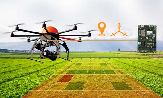
A new high-performance compact GPS/GNSS receiver with an on-board IMU sensor, tailored to the needs of UAV applications
Septentrio has released a new GNSS/INS receiver, the AsteRx-i D UAS. This multi-frequency receiver combines reliable centimeter-level positioning with 3D orientation, enabling automated navigation of aerial drones and robots.
GNSS signals received include the American GPS, European Galileo, Russian GLONASS, Chinese BeiDou, Japan’s QZSS and India’s NavIC.
With a high-performance IMU (inertial measurement unit) from Analog Devices integrated directly into the receiver board, AsteRx-i D UAS is compact and lightweight. Aboard the drone, its small form-factor combined with exceptionally low power consumption results in extended battery life and longer flight times.
“With this product we introduce into our inertial-GNSS portfolio an IMU which allows us to reduce the weight and power consumption of our UAS boards while making them easier to integrate. These are all key elements for a successful UAV platform.”
AsteRx-i D UAS is the first commercial product resulting from Septentrio’s collaboration with Analog Devices, delivering robust positioning and attitude (heading, pitch and roll) in demanding industrial environments. Both single-antenna and dual-antenna versions are available.
The single-antenna version provides a lightweight solution optimizing the system SWaP (size, weight and power). The dual-antenna version is designed for machines that need reliable heading directly from the start.
AsteRx-i D UAS comes with Septentrio’s Advanced Interference Mitigation (AIM+) technology. In aerial drones, where many electronics are crammed into a small space, neighboring devices can emit electromagnetic radiation, interfering with GNSS signals. AIM+ offers protection against such interference resulting in faster set-up times and robust continuous operation.
The on-board IMU from Analog Devices is exceptionally robust against mechanical vibrations. This IMU combined with Septentrio’s anti-shock LOCK+ technology makes AsteRx-i D UAS resilient against impact during takeoff and landing.
The AsteRx-i D UAS evaluation kit is now available in Septentrio’s online shop, which offers direct access to the company’s latest GNSS technology. For more information, contact [email protected].
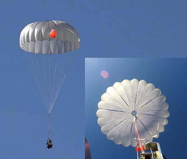
UAVOS has successfully tested its new two-stage parachute system. The new parachute system provides slow descent of a UAS at high speed. It includes two parachutes — the pilot chute and a main chute used to slow and stabilize the UAS.
The decrease in the load speed on the UAS occurs due to the main chute opening delay function, when the pilot chute opens first. The parachute system is designed for UAS with speeds of up to 280 mph (450 kph) and weight of up to 110 lb (50 kg).
Watch the parachute in action:
The pilot chute allows safe, slow descent of the UAV during the main parachute deployment, as well as to open up the main chute at a minimum altitude.
After landing, the group of the main parachute lines is automatically unfastened to collapse the canopy of the main chute and releases after touchdown to avoid dragging the aircraft along the ground. Unfastening is carried out by the lock of a three-step release:
Stage 1: Opening the pilot chute
Stage 2: Opening the main chute
Stage 3: Release of the group of lines of the main parachute
“In the aircraft safety developments, saving an entire aircraft through a deployable parachute system is a crucial thing,” said Aliaksei Stratsilatau, CEO and lead developer of UAVOS. These trials have generated an amount of data that allows us to quantify the performance of parachute system for future missions. Computer modeling cannot capture all the complexities. Parachutes encounter turbulent and dynamic airflow, which is almost impossible to replicate with computers. The only way to get a handle on all the possibilities is test.”
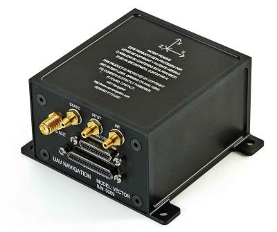
UAV Navigation has developed a Visual Navigation System (VNS) that reduces the accumulated positional error during dead-reckoning navigation. The VNS leverages visual odometry techniques to determine the position and orientation of the aircraft by analyzing and processing the images captured by a camera installed on its underside.
Initial testing in real-time flight conditions has been a success, reports UAV Navigation. The system integrates well with the company’s flight-control solution to improve navigation in GNSS-denied environments.
Vector autopilot. (Photo: UAV Navigation)
UAV Navigation’s sensors are tolerant toward GNSS failures (typically, in GNSS-denied scenarios) and can operate in dead-reckoning mode without compromising flight safety. However, a prolonged GNSS failure can lead to a significant navigation drift, and this is where the VNS comes in.
The VNS system includes a simple belly-mounted camera and image processing computer. Images from the camera are processed by a lightweight onboard computer, translating them into a relative change in the aircraft position. This information can be combined with the inertial sensors to reduce the overall drift to < 1% of the distance traveled, eliminating any drift associated with time.
Combined with the Vector autopilot, the VNS components provide a complete and robust autonomous flight control and navigation solution.
Drone maker Parrot is supporting French medical professionals facing the COVID-19 pandemic by helping Makers for Life design the MakAir respirator. This partnership comes as a part of their MakAir open source respirator project.
According to Parrot, it will be offering 500 engines for the launch of the MakAir project and will ultimately make 5,000 engines for the project. The engines will offer constant power, controlled vibrations, sufficient reliability and endurance to allow 24/7 operation for six weeks, Parrot added.
The MakAir project came to life when the COVID-19 pandemic highlighted a shortage of artificial respirators. Two other projects joined the cause to alleviate this issue. The first project, which brought together a number of manufacturers, was coordinated by Air Liquide and aims to increase the production of artificial respirators from 200 to 10,000 per year, starting in May 2020.
A second nonprofit project has spurred initiatives to create a simplified artificial respirator from standard components. Quentin Adam of the Makers For Life collective, in collaboration with Professors Antoine Roquilly and Pierre-Antoine Gourraud of the Faculty of Medicine of Nantes, and Erwan L’Her, head of the Intensive Medicine and Care Department of the Brest CHU, proposed a concept for a simplified artificial respirator.
The concept is based on using software to regulate inspiration-expiration, directly with the pneumatic system. The Nantes developer team turned to the CEA for industrialization of the concept, which had already been the subject of a proof of concept at the Brest University Hospital.
Parrot reaches milestone in U.S. Army Short-Range Reconnaissance drone program
Parrot has passed another milestone in the United States Army’s Short Range Reconnaissance drone program. As the final steps of this selection process, Parrot will participate in an operational assessment to support an Army production award decision. In anticipation of an increased demand signal from the Department of Defense, Parrot will start manufacturing prototypes of its dedicated drone in the United States, the company said.
“Parrot is honored to work with the DoD on this highly strategic project,” said Laurent Rouchon, vice president of security and defense at Parrot. “We have successfully met the high standards set over the last 12 months on the prototype efforts, and we look forward to entering this final phase and launching production in the USA.”
A roundup of recent products in the GNSS and inertial positioning industry from the May 2020 issue of GPS World magazine.
SURVEYING & MAPPING
RTK thermal mapper
Asphalt paving with RTK positioning
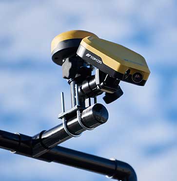
Photo: Topcon
The Thermal Mapper is designed to monitor temperature segregation to prevent future problems and measure performance, as well as provide accurate compliance reporting, using real-time kinematic (RTK) positioning accuracy. It records temperature readings behind an asphalt paver during paving and provides a visualization to operators in real time of whether the mix falls within a predefined temperature range. If the readings are unacceptable, operators can make adjustments. The system also creates data reporting files to download for applications such as U.S. Department of Energy compliance through the interactive Pavelink module, the Topcon cloud-based logistics application for asphalt paving.
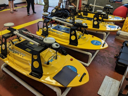
The Z-Boat 1800-T unmanned survey vessel is equipped with Trimble’s high-precision GNSS heading receiver and compatible with Trimble Marine Construction (TMC) software. The Z-Boat 1800-T enables marine construction and dredging projects to run efficiently and be monitored in real time anywhere in the world. The Z-Boat 1800-T is a high-resolution shallow-water hydrographic unmanned survey vehicle with the newly released Odom Hydrographic Echotrac E20 Singlebeam Echosounder and dual-antenna Trimble BX992 GNSS heading receiver. Each sensor is integrated into a compact, portable package for marine construction and allows data collection under harsh conditions. Both sensors can be removed and mounted on other watercraft and barges.
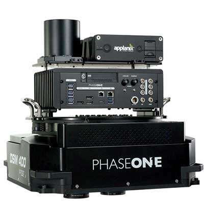
The 280MP Aerial Solution has an image coverage width of more than 20,000 pixels. The large format enables high-quality aerial surveys. Compact and lightweight, the aerial mapping solution consists of an iXM-RS 280F large-format camera, Applanix GNSS/inertial measurement unit (IMU) POS-AV receiver, DSM 400 Somag gyro-stabilized mount, Phase One iX Controller and iX Flight Management software. It is designed for use in a wide range of aircraft.
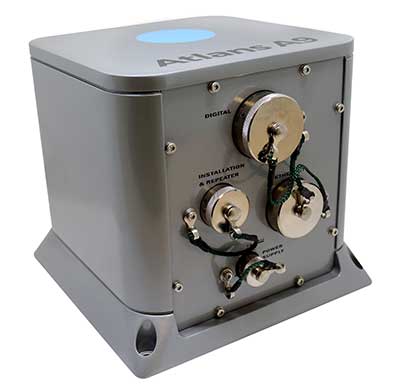
The Atlans Series of FOG-based inertial navigation systems (INS) is designed for land and air mobile-mapping applications. Based on iXBlue’s fiber-optic gyroscope (FOG) technology, the Atlans Series is a scalable range of north-seeking and north-keeping INS. They provide FOG performance to the full spectrum of land and air mobile-mapping applications and offer highly accurate positioning up to 0.01 meter in all conditions, including within GNSS-denied environments such as urban canyons, mountainous or forested areas.
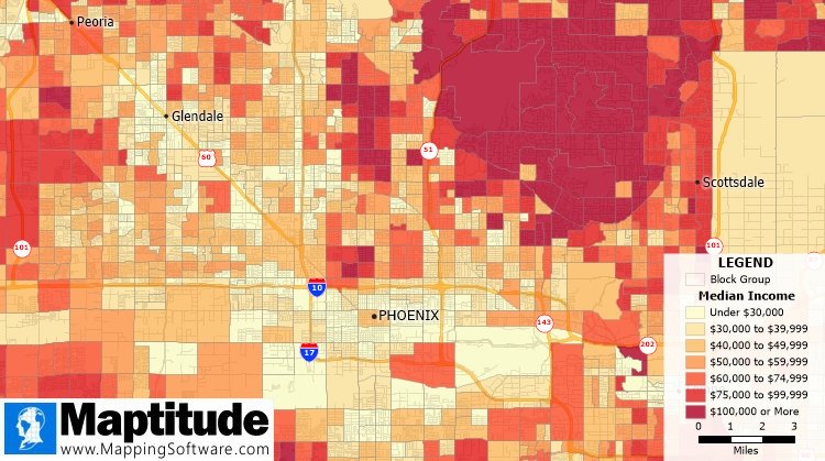
The Maptitude 2020 U.S. Census Blocks Groups data is now available for the United States. The small-area Census Summary Level is packed with neighborhood information for making accurate geography-based decisions. Users can explore locations by income, income growth, daytime population, age, race, gender, ethnicity, occupation, housing characteristics and more. The data can be leveraged by data scientists and market research analysts using the Maptitude application. The files are also available as shapefile, KML, KMZ or GeoJSON.
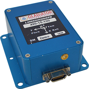
The high-performance LandMark 60 INS/GPS and compact LandMark 005 INS/GPS both feature advanced sensor-fusion technology, combining a 72-channel GNSS receiver with low-noise, high-output inertial sensors as well as barometric pressure and magnetometers. Both products use proprietary Velox processing technology and an extended Kalman filter (EKF), enabling precision position information during short-term GPS outages. The units provide accuracy of less than 2 nautical miles per hour during short-term GPS outages. The LandMark 60 provides +/– 0.3° heading accuracy and pitch/roll angle measurements of 0.1°. It is also available with an option for a real-time kinematic (RTK) GPS receiver. The LandMark 005 is less than 35 square centimeters, suitable for space-constrained applications that require a high standard of performance. Applications include flight control, navigation and stabilization for imaging, platforms and antennas. A development kit is available for set-up, configuration and data collection.
The IQCM-112 series of GNSS-disciplined oven-controlled crystal oscillators (OCXOs) incorporates an internal GNSS receiver with a 1-PPS output, which is compatible with an external GPS, GLONASS, BeiDou and Galileo source. It is housed in a 14-pin 60-millimeter-square package. When coupled to an external aerial antenna via the incorporated SMA connector, in the event of the loss of the GNSS signal the highly specified 10-MHz OCXO will switch in with a holdover capability of 1.5 µseconds for a 24-hour period, thereby maintaining lock until restoration of the reference signal. The standard operating temperature range of the module is –20° to 75° C, but it is also available with a –40° to 85° C operating temperature range. Other holdover specifications can be considered upon request.
The HC977 covers GPS/QZSS-L1/L2/L5, GLONASS-G1/G3, Galileo-E1/E5a/E5b, BeiDou-B1/B2/B2a, IRNSS-L5 and L-Band correction services, as well as GLONASS-G2. Tallysman helical antennas are designed for high-accuracy applications where precision and light weight matter, such as unmanned aerial vehicles. The antennas are available in either a robust IP67 enclosure or an embedded format. The HC977 features a low current, low noise amplifier (LNA) that includes an integrated low-loss pre-filter to protect against harmonic interference from high amplitude interfering signals, such as 700-MHz band LTE and other near in-band cellular signals.
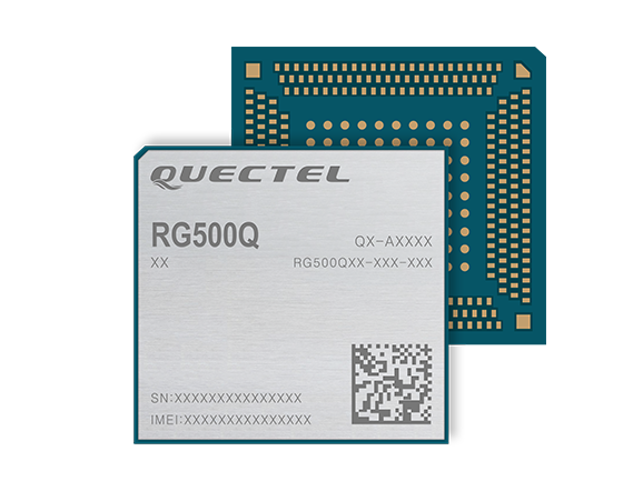
The RG500Q is a series of 5G sub-6-GHz modules optimized for internet of things (IoT) and machine-to-machine (M2M) applications. It supports the Qualcomm IZat location technology Gen9C Lite (GPS, GLONASS, BeiDou/Compass, Galileo and QZSS). The integrated GNSS receiver greatly simplifies product design and provides quick, accurate and dependable positioning capability. The RG500Q is provided in two variants: RG500Q-EA and RG500Q-NA. The RG500Q-EA 5G NR module has achieved commercial readiness and is now available to support global customers with mass deployment.
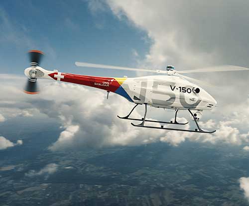
The V-150 is optimized for use from small naval vessels. It can be employed to support the homeland security, oil and gas and energy sectors. The UAV, which is free from International Traffic in Arms Regulations (ITAR) restrictions, incorporates two payload bays: up to 30 kilograms (kg) in the main bay and up to 12 kg in the nose. Within these, it provides a variety of payload options, including powerful electro optical and infrared (EO/IR) sensors, hyperspectral and multispectral cameras for airborne remote sensing, lidar and a variety of small tactical synthetic aperture radars (SAR) for delivering real-time intelligence in all weather conditions.
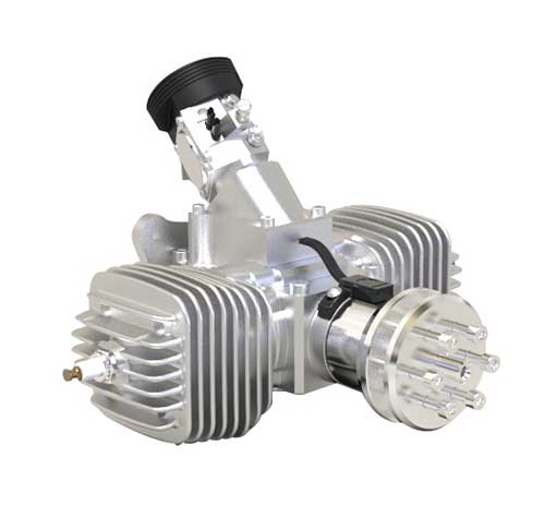
The SP-56 series is a family of small two-cylinder engines for UAVs. It can be integrated into small helicopters, which require smoother engine operation than single cylinders can provide. The SP-56 series provides 3.35 KW at 7,000 rpm; total weight of the carbureted version is 2.6 kilograms. The engine can be equipped with a generator or a starter generator on the rear output shaft. Hybrid applications are possible in which the engines are used only to generate electricity.
Two new small unmanned aerial systems (sUAS) are available to U.S. government defense and security markets. Vector and Scorpion form a 2-in-1 rucksack-portable system with an open source operating system, Auterion OS. The Scorpion tricopter can be used for dynamic urban environments and missions that require maneuverability and hover to collect intelligence, surveillance and reconnaissance (ISR) data. A tethering system enables 24/7 operations. By configuring the base fuselage with fixed wings and tail section, Scorpion transforms into Vector, a fixed-wing vertical takeoff and landing (VTOL) UAV for long-range, long-endurance ISR missions.
Insta360 ONE R is an interchangeable-lens action camera designed with three swappable Lens Mods for capturing different kinds of content. It has a Dual-Lens 360 Mod and a 1-Inch Wide Angle Mod co-engineered with Leica Camera AG. Advanced stabilization with Insta360’s FlowState algorithm achieves gimbal-like stabilization when shooting 360 degrees or with a standard wide angle lens. The 5.3K wide-angle lens can be swapped for a dual-lens setup that captures action in all directions at once. It captures brilliant 5.3K video and 19-megapixel photos even in complex lighting conditions. The ONE R is waterproof to 5 meters.
SUGUS — a European Commission project to promote European GNSS services for the integration of drones into the airspace — is conducting an online survey of stakeholders.
SUGUS, the European Commission’s project for the development of European GNSS (Galileo and EGNOS) services for U-space, is carrying out a survey to identify, gather and understand stakeholders’ needs, and to improve user experience of E-GNSS in complex operations and built-up areas.
U-space is a set of new services and specific procedures designed to support safe, efficient and secure access to European airspace for large numbers of drones.
SUGUS members invite all the stakeholders to take part in the survey, including suppliers of U-space services, manufacturers of unmanned aerial systems (UAS) platforms and GNSS receivers, UAS pilots and operators, public bodies, authorities and organizations, and centers for UAS testing and training.
The survey will be available until May 15.
The survey results will be used as a valuable input to tailor the E-GNSS Service Provision layer to specific drone missions’ needs, allowing a better mitigation of risks in complex operations like BVLOS (beyond visual line of sight) and UAM (urban air mobility), increasing safety and security.
Also, the points of view collected will help to define the requirements and then the implementation of a new E-GNSS-based API which will deliver live and forecast information about performance, coverage, alerts to users and more.
The API will be called upon by UTM service providers, UAS designers or UAS systems developers, and integrated in existing commercial solutions.
“The survey organized by SUGUS is a key element for E-GNSS Programs to capture user requirements of the drone community,” explained Miguel Aguilera, European Commission advisor. “The results will be used to enhance EGNOS and Galileo Service Provision targeting drone operations, increasing safety and security, and facilitating a swift and efficient deployment of U-space.”
SUGUS Project
SUGUS (Solution for E-GNSS U-Space Service) is a European Commission’s project to promote European GNSS services (EGNOS and Galileo) for the drone market and for the effective and safe integration of these aerial platforms in the airspace.
It is a European Union H2020 R&D project to be carried out by GMV (main contractor) with everis Aerospace, Defense and Security as co-leaders of a consortium also involving VVA Brussels, ESSP, FADA-CATEC and Unifly.
SUGUS will help to develop services geared towards the effective integration of drones into the airspace. A series of trials will be held to show the benefits of E-GNSS for drone operators, as well as its approval by aviation authorities.
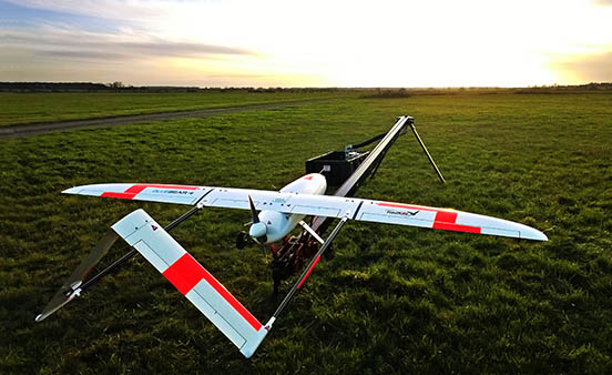
Launch of the RedKite drone. RedKite is a long-endurance sub-20-kg UAS designed to carry payloads of up to 5 kg. (Photo: Blue Bear Systems)
Blue Bear Systems Research Ltd. has successfully demonstrated a fully autonomous suite of multiple drone swarm assets under beyond-visual-line-of-sight (BVLOS) conditions.
The technology enables complex drone operations where multiple assets are able to carry out simultaneous tasks controlled by a single user to create a swarm effect.
The five fixed-wing drones clocked up to 15 hours of flying time, over four days, in challenging weather conditions. The swarm comprised a combination of Blue Bear’s Redkite and Cobra fixed-wing systems, which flew multiple simultaneous sorties from a test range in the northwest of England.
The drones were equipped with the latest automatic dependent surveillance-broadcast (ADS-B) technology, and the airspace was managed by Blue Bear’s airspace deconfliction software. All of the assets were controlled by a single operator from Blue Bear’s mission command control system in Bedfordshire, England.
“This is an exciting development for us, proving our ability to operate multiple drones, simultaneously, using the latest Blue Bear technology to deliver a swarm effect under BVLOS conditions,” said Ian Williams-Wynn, managing director of Blue Bear Systems.
Image: 4X-image iStock / Getty Images Plus / Getty Images
Nearly 4,000 waivers granted under Part 107; about 20 percent of waivers granted to organizations received by first responders
Almost four years after the Federal Aviation Administration (FAA) established rules for the commercial operation of small unmanned aircraft systems (UAS), a new report by the Association for Unmanned Vehicle Systems International (AUVSI) found that nearly 4,000 operators across all 50 states have been granted waivers to go beyond current regulations.
First responders across the country received about 20 percent of all waivers granted to organizations (398), which demonstrates growing interest and need for public safety applications enabled by UAS, including search and rescue and firefighting at night.
Effective Aug. 29, 2016, the small UAS rule, also known as Part 107, created a uniform regulatory framework for UAS. Among the rule’s requirements, UAS must fly below 400 feet above ground level (AGL), within visual line of sight and during daylight hours.
Recognizing the need for the rule to be flexible to foster innovation, the FAA created a waiver process that allows for expanded types of operations, such as nighttime or beyond line of sight operations, with the approval of the agency.
AUVSI analyzed 3,946 of these waiver documents granted by the FAA since Part 107 went into effect. While the vast majority of waivers (3,636 or 92 percent) were granted to waive the requirement for flying only during the daytime to enable nighttime operations, the FAA has also granted waivers from other sections of the regulations to permit advanced operations, including:
Flights over people (112 waivers);
Operation in certain airspace (97 waivers);
Operating multiple UAS at the same time (55 waivers);
Visual line of sight operations (to enable beyond line of sight operations) (51 waivers).
Operators in all 50 states, as well as the District of Columbia and Puerto Rico, have received waivers. California leads the way with 451 waivers granted, followed by Texas (334), Florida (272) and New York (159). About 87 percent of all waivers were granted to small businesses with fewer than 10 employees and annual revenues of less than $1 million.
“Across the country, operators have demonstrated they are eager to harness the tremendous potential of expanded UAS operations,” said Brian Wynne, president and CEO of AUVSI. “Small businesses have been able to save time and money, and first responders and public safety agencies have used UAS technology to increasingly contribute to the greater good worldwide, supporting missions from disaster relief to humanitarian aid.”
Last month, AUVSI submitted its comments on the FAA’s Notice of Proposed Rulemaking (NPRM) for Remote Identification of UAS. In the comments, AUVSI urged the FAA to proceed concurrently with rulemaking that would allow for expanded operations rather than wait for a fully implemented remote ID rule to avoid unnecessary delays. The FAA says it hopes to issue a final rule before the end of the year.
In the interim, the FAA recently announced several initiatives to improve the waiver application process in response to a review last year of the waiver framework by a task group of the Drone Advisory Committee that was chaired by Wynne.
The FAA’s plans include expediting the waiver renewal application process, particularly in instances where there hasn’t been many changes since the original application; enabling quick administrative changes to previously granted waivers; providing more responsive feedback to applications that were not approved; streamlining the applications; implementing new regulations to obviate the need for waivers; and increasing transparency and accountability to provide support for waiver applications, disapprovals, and general UAS questions.
“The waivers that have been granted so far demonstrate that operators are safely able to conduct expanded operations, such as flights over people and beyond visual line of sight,” said Wynne. “While improvements to the waiver process are needed and welcomed, we urge the FAA to move forward rapidly with rulemakings that would enable these operations widely and provide the economic and societal benefits they offer.”
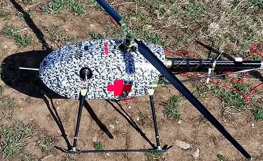
UAVOS has successfully tested its cargo delivery UVH-170 unmanned helicopter. The trial aimed to validate a highly automated delivery flight from a vendor to a destination and back, across precisely pre-selected pathways.
The flight took 1.7 hours and covered a standoff distance of 62 miles (100 kilometers). Critical humanitarian aid weighing 17.6 lbs (8 kg) was delivered with neither the need to land nor the need for a ground-control station on the receiving side.
UAVOS’s UAS is equipped with line-of-sight data link (LOS) and satellite communication data link, which supports beyond visual line of sight (BVLOS) flights. Watch the cargo delivery UVH-170 UAV in action.
UVH-170 unmanned helicopter is designed for commercial operations and immediate air response, emergency relief under demanding conditions and tight timescales. The aircraft’s high standoff distance makes it well-suited to humanitarian and disaster relief applications.
The capabilities of the UVH-170 unmanned helicopter address many social (medical, pharmaceutical, remote communities, humanitarian aid, etc.) and economic (mining, oil and gas, courier, etc.) use-cases being requested by customers.
The solution is based on the gasoline engine UVH-170 unmanned helicopter. With a maximum take off weight of 99 lb (45 kg), and a payload of up to 22 lb (10 kg), the UVH-170 flies at an altitude of less than 8,200 ft (2,500 m) at maximum speed of 74 mph (120 kph).
“As we have seen during the trials, the customers can derive significant benefits from the use of the UVH-170 UAV,” said Aliaksei Stratsilatau, CEO and Lead Developer of UAVOS. “As a robust VTOL platform, the UVH-170 does not require any additional take off or recovery equipment, which makes it perfect for delivery to remote areas. Besides, the unmanned helicopter has demonstrated capability to operate in windy conditions with gusts more than 14 mps.”
UAVOS has offices in Hong Kong, the United States and Europe. Among UAVOS’ unmanned technologies is the high-altitude pseudo-satellite (HAPS) ApusDuo, multi-platform autopilot solution for converting manned vehicles of all types into unmanned, and unmanned aerial vehicles aimed to counteract systems of electronic warfare.
Feature photo: UVH-170 unmanned helicopter is designed for immediate deliveries. (Photo: UAVOS)
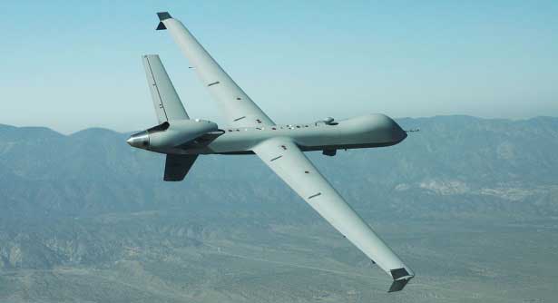
General Atomics MQ-9 Predator. (Photo: General Atomics)
There has been a lot of scene stealing by General Atomics recently with Predators flying hither and thither, new orders for the Boeing-Navy unmanned re-fueling drones and a UAV flying on Mars — this month’s unmanned aircraft summaries.
The Predator is the archetypical unmanned aircraft which most people might visualize as a “drone” as a result of numerous news reports and photos. Its what we might refer to a “Large UAV” with a 65-ft. wingspan, a 35 ft.-long fuselage and weighing in at around ~10,500 pounds fully fueled.
The SkyGuardian. (Photo: General Atomics)
In fact it’s bigger than a small manned aircraft, like the single engine Cessna 182 which checks in at 36ft wingspan/29ft fuselage. So its clear that something this big and without an on-board driver has to watch where its going, especially when flying within in the US National Airspace System (NAS).
So it was no small feat when General Atomics recently flew a new MQ-9 Predator on a delivery flight from its flight ops center in Palmdale, California, to the Holloman Air Force Base in New Mexico. There was significant coordination by the flight teams in both locations, and with the approval by the FAA. Delivering a new Predator by air saves the Air Force significant manpower, as normally new ones arrive in a crate and require effort to re-assemble.
It’s a sign of progress towards achieving approval to allow regular flights of such large UAVs in the NAS. Nowadays a Cessna 182 pilot can file a flight plan and then basically fly anywhere in unrestricted airspace. Hopefully one day — as a consequence of following rigorous certification verification and FAA approval – pilots of such Large UAS will be authorized to operate in a similar fashion.
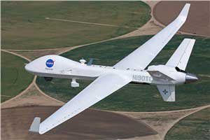
General Atomics is working with the U.K. Royal Air Force (RAF) to develop and certify the all-weather, long-endurance SkyGuardian MQ-9B variant to meet NATO-standard Type-Certification requirements, which will then enable the UAV to be flown in civil airspace. The Australian Defence Force (ADF) has also selected this UAV variant for its unmanned applications in and around Australia. In late March, General Atomics flew the first production representative SkyGuardian – known to the RAF as the ‘Protector’ – out of its flight ops facility in El Mirage, California.
Staying with the military theme, Boeing has been working with the US Navy to develop a UAV that can land on aircraft carriers, and following a concept change by the Navy, won a contract to provide tanker UAVs. Tanker UAVs will fill up with aircraft gas on an aircraft carrier or land base, then take off and fly to rendezvous with fighter aircraft to transfer fuel and extend fighter endurance and range.
Right now tanker aircraft are usually quite large aircraft – like the Boeing KC-46A tanker which is based on the Boeing B-767 civil transport aircraft which many of you may have flown on as passengers.
The MQ-25 is still in its initial phases, with four test UAVs slated to undertake the initial flight test program. The first test vehicle has already begun exploring the UAV flight envelope and has 30 flight-test hours under its belt. The Navy has just shown confidence in the program by ordering another three aircraft, bringing the total initial build to seven vehicles.
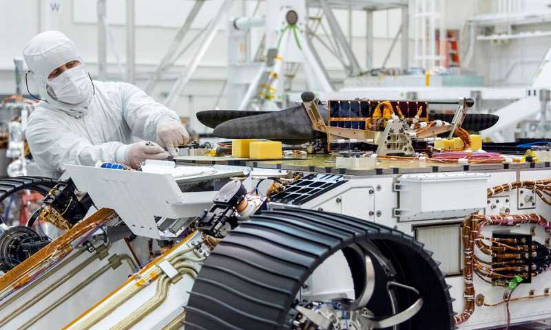
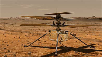
Its easy to see that UAVs are showing themselves to be extremely useful to military forces, but it might be difficult to understand how a UAV might find itself in the U.S. space program. The “Mars Helicopter” has just been mated to the underside of the next Mars Rover — now called “Perseverance” — both are slated to leave on their eight month journey to Mars in July this year.
Mars UAV being mater with Perseverance. (Photo: NASA)
With two ~4ft rotors which spin in opposite directions, the UAV will have to wait patiently for up to 90 Martian Days after Perseverance touches down in February 2021 until it gets a chance to prove that it can fly in the thin Mars atmosphere — chamber tests here on Earth in simulated Mars air have already shown that flight should be feasible.
Built to withstand high g launch and vibration forces and those of the Mars landing, the UAV carries a high resolution camera which is used for navigation, landing and survey of Mars’ surface. Its also designed to withstand the extreme temperatures and high radiation environment on the surface of Mars. The UAV is equipped with a dual-processor flight controller linked to sensors which include a gyroscope, an altimeter, visual odometer, hazard detectors and a ‘visual inertial nav system’ developed by JPL. Although the Mars Helicopter operates autonomously, it communicates with and receives control inputs from the lander, so controllers on Earth load up the flight plan ahead of time into the lander, and then wait for the helicopter UAV to execute the commands. Don’t expect vast coverage of huge panoramas of Mars – its flights are each intended to be more of an extensive hop lasting around 90 seconds at 10-15 ft above the terrain.
Mars Helicopter on simulated Mars surface. (Photo: NASA)
With a body no larger than a softball and weighing less than 4 pounds, the Mars Helicopter is an experiment to see if its possible to fly in the extremely thin Martian atmosphere. With less than 1% the density of our sea-level atmosphere, its necessary to spin the rotors at 2,800 rpm, ten times faster than on Earth. The UAV collects power from its own small solar panel and needs several days to recharge after each flight — of which five are planned. The main objective if flight is possible is to pre-survey interesting potential routes for the lander.
So preparations for large UAVs to regularly fly in civilian airspace, a new approach for Navy refueling systems, and a helicopter UAV destined to fly on Mars next year — completely different unmanned applications, all making progress.
The European Space Agency (ESA) has funded Ampyx Power, developer of a next-generation wind energy technology, and Omnisense, developer of locating and tracking solutions, to develop a robust fail-safe navigation system.
The positioning solution will be used for automated take-off and landing of Ampyx Power’s wind-energy aircraft when applied offshore or over rugged terrain. The technology will be enabling as well for other drones in critical applications.
Ampyx Power develops airborne wind energy systems (AWES) using autonomous tethered aircraft as a means for generating electricity on the ground. The launch and land deck is smaller than the wing span of the aircraft. High accuracy, availability and integrity of the relative positioning between aircraft and platform is required during the final horizontal approach to ensure safe landing of the aircraft in the case of GNSS outage.
The funding will cover the integration into the navigation solution of a local positioning system that seeks to provide 10 centimeters of relative positioning accuracy with 100-Hz update rate and an operating range up to 1 kilometers. Ultra-wideband positioning techniques will be used to make this happen.
“The project allows us to integrate a backup local positioning system into the existing high-end navigation solution,” said Michiel Kruijff, head of technology at Ampyx Power. “This novel navigation technology will ensure that our aircraft can overfly the platform with great accuracy, even in case of GNSS failure. This solution is particularly relevant for use cases in rugged terrain or offshore where other affordable means of relative positioning would be too costly or would offer insufficient performance or availability. We seek such a high level of system robustness both for commercial reasons and for safety reasons, in line with our certification approach with the European Aviation Safety Agency (EASA).”
“We are pleased to offer our innovative local positioning system (LPS) to this project,” said Andy Thurman, CEO at Omnisense. “The closely time-synchronized fusion of ultrawideband (UWB) signals exchanged between landing deck and aircraft mounted Omnisense beacons, will allow highly accurate range measurements to be provided to the drone autopilot, enabling continuous operation in the safety critical landing phase. The enhanced capabilities which arise as a result of this project will enable Omnisense to extend the market reach for our flexible LPS offering from the industrial asset and animal tracking markets in which we currently operate, to more dynamic applications such as GNSS denied drone control, autonomous vehicles in smart cities and sports performance analysis.”