Tag: autonomous vehicles

  • NXP and Auterion join on hardware/software integration for drones

    NXP and Auterion join on hardware/software integration for drones

    NXP and Auterion join forces to enable next-generation secure drone fleets with automotive certified solutions, high-reliability networking, and a scalable and open software platform.

    Photo: narvikk/ iStock / Getty Images Plus/Getty Images
    Photo: narvikk/ iStock / Getty Images Plus/Getty Images

    On July 6 at the PX4 Developer Summit 2020, NXP Semiconductors and Auterion announced a collaboration to develop integrated hardware and software solutions for the unmanned aerial systems industry.

    Working together, the companies aim to develop highly reliable and advanced hardware and software solutions deployable in an unmanned aerial vehicle.

    With the development of regulations and the increasing number of autonomous systems in the field, the requirement for components and software that are certifiable and the ability to deploy intelligence on the edge is becoming more and more important.

    NXP provides semiconductor components and expertise leading to certifiable electronics solutions, including computational horsepower, secure element for encryption and authentication, and high reliability automotive networking.

    Auterion is offering the hardware reference design and Auterion Enterprise PX4, the software for the flight controller and the mission computer to make drone fleets safe and fully integrated into workflows. Auterion is the largest contributor to PX4 and builds its software platform on open standards, ensuring that enterprises have access to a managed and tested distribution of the open source technology.

    The partnership addresses the needs of the unmanned aerial vehicles industry for compatible hardware and software solutions that will help drone manufactures bring state-of-the-art products to market. The aim is to ensure that manufacturers have a streamlined path to certification and are connected to existing workflows.

    “This partnership will enable the mobile robotics community with the components meeting quality specifications needed to ensure functional safety and security in drones and rovers based on reliable long life industrial and automotive parts and reference designs,” said Iain Galloway, Drone Program Lead, Systems Innovation, NXP. “We have been participating in the open source PX4 community for several years now and with this close relationship with Auterion, and Auterion Enterprise PX4, we are excited to work together to ensure these vehicles are prepared to meet current and future regulations and standards governing modular safe drone architectures.”

    “Safety is the number one priority in commercial drone operations. NXP’s leading position as a semiconductor provider for safety-critical automotive applications is the perfect pairing for Auterion’s enterprise-grade drone software platform,” said Lorenz Meier, co-founder and CEO, Auterion. “Together, we will be able to provide integrated hardware and software solutions to the drone industry that combine high-performance compute with safety-first engineering.”

    NXP and Auterion will collaborate on the core hardware and software components of an autonomous system, this includes, but is not limited to, the following topics:

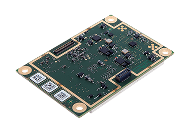
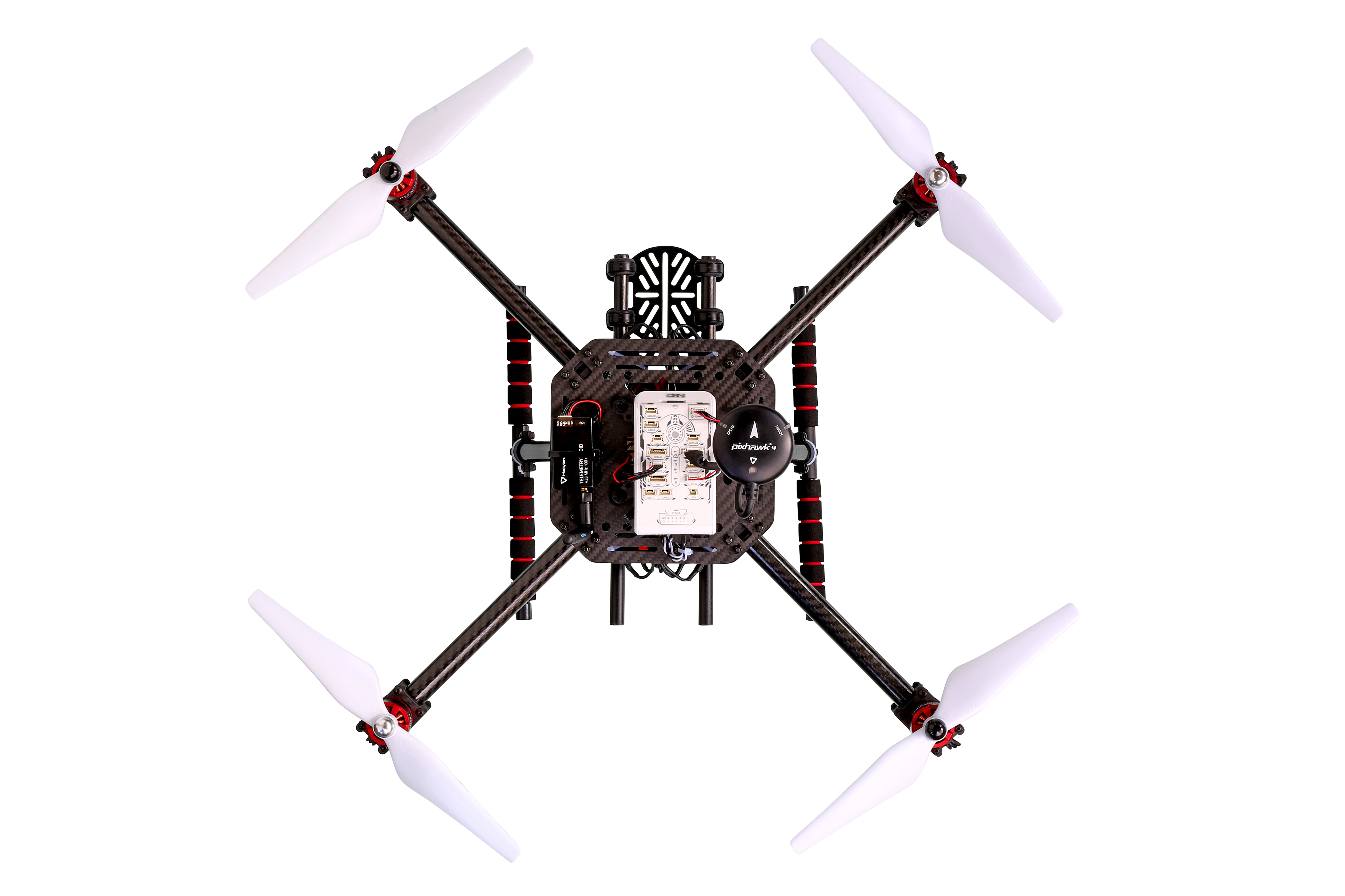
    Developing the next generation Auterion Skynode avionics module reference design, based on the latest Pixhawk autopilot Reference Standards and on the NXP i.MX 8M Mini as a companion computer, and on future components in this family.

    • Integrating navigation modules incorporating NXP Ultra-Wideband (UWB), automotive MCU, NFC and authentication for precision landing applications.
    • Developing Battery Management System (BMS) solutions based on the latest Pixhawk Smart Battery Standards.
    • Developing Automotive CAN and CAN-FD node solutions supporting popular software protocols such as UAVCAN and MRCAN for mobile robotics peripherals.
    • Collaborate in the data cybersecurity and drone regulatory space to help shape and meet future regulations.

    Both parties will continue to support the PX4 open source community and upstream PX4 development, in an effort to enable the whole industry.

  • KVH inertial sensor integrates photonic chip technology

    KVH inertial sensor integrates photonic chip technology

    New patented PIC Inside technology is designed to enhance inertial sensor performance and reliability for the growing autonomous market

    Photo: KVH
    Photo: KVH

    KVH Industries has launched the P-1775 inertial measurement unit (IMU), featuring KVH’s new PIC Inside photonic integrated chip (PIC) technology.

    KVH has been developing and testing the technology for more than three years and is now incorporating it into existing product lines. The first units have started shipping.

    One of the first customers has integrated the P-1775 IMU into its next-generation rocket launch vehicle.

    KVH’s PIC Inside technology features an integrated planar optical chip that replaces individual fiber-optic components to simplify production while maintaining or improving accuracy and performance.

    The PIC Inside product is designed to deliver 20 times higher accuracy than less expensive MEMS inertial measurement units, uses modular designs for ease of integration, and has outstanding repeatability unit-to-unit.

    “I applaud the tremendous effort by our incredible engineers in developing this groundbreaking technology and I am thrilled that we have begun to incorporate PIC Inside technology into our existing products, a process that we expect to continue throughout the year,” said Martin Kits van Heyningen, KVH CEO.

    The PIC technology will be added to KVH’s inertial sensor product line for use across a broad range of applications from navigation to stabilization and pointing. KVH’s fiber-optic gyros (FOGs) and FOG-based products are particularly well-suited for the large and growing autonomous market. This market includes applications on land, sea and air, such as drones, people movers, trucks, and mining and construction equipment.

    Autonomous applications rely on high-quality inertial sensors to deliver an extremely accurate navigation solution, delivering the performance required in critical metrics such as angle random walk (ARW) and bias instability.

    Next-generation driverless cars, which require centimeter-level precision for safety, are the ideal application for KVH’s inertial products, KVH said. Employing the PIC design allows for a lower cost and scalable solution due to the elimination of various fiber components and a reduction of labor.

    In 2019, KVH delivered its first product prototypes containing PIC technology to automotive customers and presented the science behind the technology to an audience of engineers at an inertial sensor conference, describing the extensive development, testing, and benefits of the new technology.

    KVH is a leading innovator for assured navigation and autonomous accuracy using high-performance sensors and integrated inertial systems. KVH’s widely fielded TACNAV systems are in use by the U.S. Army and Marine Corps as well as many allied militaries around the world. KVH’s FOGs and FOG-based IMUs are in use today in a wide variety of applications ranging from optical, antenna and sensor stabilization systems to mobile mapping solutions and autonomous platforms and cars.

  • New DJI map tracks drone-assisted rescues worldwide

    New DJI map tracks drone-assisted rescues worldwide

    Global reference includes more than 400 people rescued by drones to date

    DJI has launched an online reference to track events around the world when a drone helped rescue someone from peril. The Drone Rescue Map shows how more than 400 people around the world have been helped by drones in more than 200 emergencies, and will be continually updated as new rescues occur.

    The DJI Drone Rescue Map has been compiled from news stories and social media posts from authoritative sources such as police departments, fire departments and volunteer rescue squads.

    Each entry on the map includes the location and date of the incident, a brief description, a link to the original story or post, and an easy way to share those incidents online. To make the map as definitive as possible, DJI encourages public safety agencies to share additional drone rescues so they can be included.

    Once a week on average

    The map includes rescues recorded in 27 countries across five continents, and shows how drone technology has moved from an experimental concept to standard public safety equipment.

    The first drone rescue was recorded in Canada in 2013, the next one was more than a year later, and early examples of drone rescues were as likely to be performed by helpful bystanders as by professionals.

    Today, drone rescues are reported about once a week on average, and public safety agencies routinely share those success stories on social media.

    Screenshot: DJI Drone Rescue Map
    Screenshot: DJI Drone Rescue Map

    “The DJI Drone Rescue Map is now the best global reference for how effective drones are in emergencies, and allows the world to see the tremendous impact drones have had in finding lost people, shortening searches, reducing risks to rescuers and saving lives,” said Romeo Durscher, DJI senior director of public safety integration. “Public safety workers already know how drones are revolutionizing their work, and now the rest of the world can see their amazing stories in one place. The DJI Drone Rescue Map honors the incredible rescues they’ve made, and will allow everyone to see how drones help save people in the future.”

    Types of rescues

    The map includes instances of drones:

    • finding people lost in forests, fields and mountains, often in darkness using thermal imaging cameras
    • dropping life preservers to people struggling in water
    • locating boaters stranded on remote waterways
    • helping rescue people who were at risk of harming themselves.

    The map does not include incidents when a drone is simply used as part of a larger search process; instead, a drone must have directly located, assisted or rescued a person in peril.

    Many of these incidents illustrate how drones can find missing people more quickly than a traditional ground-based search, allowing victims to be brought to safety faster, more easily and with less risk and burden for their rescuers.

    In some of the incidents on the DJI Drone Rescue Map, the drone helped accelerate a rescue and allow first responders to operate more efficiently.

    In other incidents, the drone clearly made the difference between life and death.

    Volunteer rescue

    “I know how important drones are for people in distress, because a drone saved my life,” said Jason Mabee, a Maryland man who was injured and near death last year in a local park when he was found by a volunteer drone pilot. “My family and I are eternally grateful that a total stranger was able to use his drone to find me. It’s comforting to know that drones are helping so many other people around the world too, and I hope the DJI Drone Rescue Map demonstrates just why drones are so important in emergencies.”

    “Drones have changed the game for finding and saving people lost in difficult conditions, and twice last year drones made the difference for us in finding and saving stranded hikers in dangerous terrain at night,” said Kyle Nordfors, Drone Team Coordinator for Weber County Search and Rescue in Utah. “Drones helped make these rescues possible while reducing risk and strain on our volunteer rescue force. We’re excited to see our successful efforts represented on the DJI Drone Rescue Map, and we hope it shows people all over the world how important drones are for saving lives and protecting the rescuers.”

    Screenshot: DJI Drone Rescue Map
    Screenshot: DJI Drone Rescue Map

    Rapid increase in rescues

    DJI has previously released two detailed reports on how drones have been used to rescue people from peril around the world. The first, in 2017, counted 59 people rescued by drones, and the second saw the global total rise to 124 by 2018.

    PC Tom Shainberg, senior drone pilot of the Alliance Drone Team for the Devon & Cornwall and Dorset police forces in England, said, “The Alliance Drone Team is proud to be a leader in adapting drone technology for police incidents, and we’re glad to see our successful drone rescues — such as finding a vulnerable man huddled near the edge of a cliff — being shared wider, along with similar accomplishments from other public safety agencies from around the world via the Drone Rescue Map.”

    “Hundreds of examples now make clear that making drones widely accessible, with low barriers to entry and subject to a progressive set of operational regulations, leads inevitably to saving more lives around the world,” said Brendan Schulman, DJI Vice President of Policy & Legal Affairs. “The DJI Drone Rescue Map is a powerful resource for policymakers to understand the impact drones have on protecting vulnerable people in their own communities, and the detrimental consequences of policies that would restrict or discourage the use of drones, or increase the cost of using them. Regions with less favorable operating rules for drones appear to have substantially fewer reports of drone rescues.”

    Seeking submissions

    DJI monitors global news coverage, drone-related social media, and other sources to find new examples of drone rescues, but understands that many similar incidents may not yet be recorded on the map.

    Anyone who knows of a drone-involved rescue not included on the DJI Drone Rescue Map can submit it through a form at the bottom of the map page.

    These submissions will be reviewed for publication on the map, so DJI asks anyone submitting information about a rescue to respect the privacy rights and expectations of the persons involved, and to not share any confidential or sensitive information about agency operations.

  • Altitude Angel, Inmarsat offer air traffic management for UAVs

    Altitude Angel, Inmarsat offer air traffic management for UAVs

    Logos: Altitude Angel, Inmarsat

    Altitude Angel and Inmarsat are collaborating to develop and deliver advanced flight tracking and management capability for UAVs.

    According to the companies, they will build on Altitude Angel’s GuardianUTM platform to jointly develop a “pop-up UTM” capability that can be deployed anywhere it is required to manage beyond visual line of sight UAV flights, without the need for ground-based communications infrastructure. By utilizing Inmarsat’s global network of satellites and leveraging its experience in air traffic management communications, Altitude Angel’s pop-up UTM can be accessed rapidly and deployed worldwide, the companies added.

    The pop-up UTM will be developed initially to address the unmanned traffic management needs of blue light emergency services and first responders who need aerial surveillance rapidly with little notice. The companies plan to release a commercial, industry-focused product soon after. Through this technology, emergency services will be able to remotely manage UAVs, increasing their range of safe operations in mixed airspace of manned and unmanned vehicles.

    “The ability to almost instantly ‘pop-up’ safe, secure and fully operational UTM platforms in any environment, at any time, will give first responders, blue light services and aid organizations a valuable tool that could save countless lives,” said Phil Binks, head of air traffic management at Altitude Angel. “Altitude Angel and Inmarsat, in developing ‘pop-up UTM,’ will be able to bring connectivity, clarity and automated air traffic control services for UAVs in even the most challenging of circumstances.”

    Altitude Angel is an aviation technology company delivering solutions which enable the safer integration and use of fully automated drones into airspace. Inmarsat is a British satellite telecommunications company, offering global mobile services.

  • GNSS helps fight coronavirus while companies adapt

    GNSS helps fight coronavirus while companies adapt

    As part of the effort to combat the spread of COVID-19 in the United States, UAV company Draganfly has partnered with Australia’s Department of Defense (DOD), the University of South Australia (UniSA) and Vital Intelligence, a company that collects and analyzes healthcare data, to remotely detect and monitor people with infectious and respiratory conditions.

    Draganfly’s UAVs will be fitted with a specialized sensor and computer vision system that can monitor people’s temperature, heart rate, and respiratory rate, as well as detect people sneezing and coughing in crowds. The collaboration, called The Vital Intelligence Project, utilizes technology developed with help from the DOD’s Science and Technology Group. Draganfly was selected as the exclusive integration partner on March 25, with an initial budget of up to $1.5 million to commercialize and deploy the technology.

    The UAV uses u-blox LEA-M8S GNSS modules integrated into the company’s own interface printed circuit boards.

    In late January, recalled Draganfly’s CEO Cameron Chell, the company began to consider what kinds of health data it could collect and analyze that could help public officials and private-sector managers flatten the pandemic’s curve. It then contacted Javaan Chahl, a UniSA researcher who had been a customer for 20 years, to discuss the use of UAVs for this mission.

    The technology was originally designed to be deployed on helicopters in disaster relief operations, to measure the vital signs of survivors. It was then adapted to measure the health of wildlife populations, such as herds migrating or threatened by drought or fire, and in hospital neonatal wards to monitor the vital signs of newborns.

    To provide core temperature readings as well as measurements of heart rate and respiratory rate, the technology uses RGB and thermal cameras, both fixed and mounted on UAVs. “The public sector and the private sector are both interested in this technology, but are approaching it very differently,” Chell said.

    The system’s capabilities include detecting people who are coughing, not wearing masks, or clustering in violation of social-distancing rules. The objective is to provide population health information to public agencies to help them make better decisions by measuring the effectiveness of their COVID-19 policies in real time, rather than react to past information. The system, Chell stressed, does not record data on individuals but reports such figures as “84% of the people are socially distancing 24% of the time.”

    “Based on what I see unfolding with the measurement and data industry as it relates to health technology,” Chell said, “six or eight months from now you are likely to see health measurement reports the same way that you see weather reports. Eventually, it will be broadcast to the consumer. That is our objective.” People, he predicts, will use these reports to make decisions about where and when to travel.

    To obtain accurate core temperatures, Draganfly’s thermal sensor needs to be about 20 feet away from its subject, and uses software to zoom in on the tear ducts. To obtain heart and respiratory rates requires about 25 seconds of footage with at least a 4K camera, magnification to detect body micromovements, and machine vision to detect skin tone biometric measurements. The system also picks up movements — such as of the shoulders, lumbar area and upper torso — that indicate coughing, Chell points out. “The results certainly have been promising in terms of having real quantitative data,” he said.

    The scenario is somewhat different in the private sector, which typically relies more on fixed-based cameras for entranceways — for example, to monitor workers entering a warehouse, a factory or a shipyard to guard against people who are infectious or have a respiratory disease. “We have seen several announcements by companies that they are using thermal cameras to do this,” Chell said. People pass through the company’s fixed system, which uses both thermal and RGB cameras, in less than three seconds, according to Chell, which is good for such facilities as parks, office buildings and convention centers. Private organizations can then ask people who exhibit certain symptoms to consent to a secondary screening in exchange for access.

    Additionally, Draganfly will provide UAV services for disinfecting outdoor facilities.


    Find out how more companies are helping fight COVID-19.


    Featured photo: Draganfly

  • TopXGun Robotics uses drones to fight COVID-19 from above

    TopXGun Robotics uses drones to fight COVID-19 from above

    Photo: TopXGun/Septentrio
    Photo: TopXGun/Septentrio

    In early February, TopXGun Robotics — based in Shanghai, China — started to use 10L drones for spraying disinfectant to help fight COVID-19. Six volunteers provided free disinfectant spraying service to more than 10 large companies, factories and universities, covering about 800,000 square meters in the Shanghai area.

    TopXGun outlined the advantage drones have over manual spraying.

    Safety. Using a UAV means no wokers inhale disinfectant. Pilots stay distant, and no one enters a sprayed building until it is safe.

    Effectiveness. By spraying from above, drones can reach difficult locations, such as a landfill or a roof. Reportedly, the spray can kill the virus in the air.

    Cost-savings. Only one pilot and one assistant are required to operate, reducing labor costs.

    The 10L drones are equipped with Septentrio’s high-precision GNSS, which provides robust anti-spoofing and anti-jamming capabilities, important in urban areas.

    Before spraying, TopXGun used a XC-05 vertical-takeoff-and-landing (VTOL) drone to survey the area. With reliable real-time kinematic (RTK) technology from the Septentrio receiver, the survey drone accurately generated a map of the operation area, marking the flight route. In this way, the spraying drone could fly and spray automatically in most cases. If the operation area is in an irregular shape or has obstacles in the middle — such as poles or trees — the mapping pilot can use markers to indicate these obstacles so the spraying drone will avoid it.

  • Draganfly, MicaSense partner on agriculture package for crop imaging, data

    Draganfly, MicaSense partner on agriculture package for crop imaging, data

    The Draganflyer Commander Ag-Pro Package. (Photo: Draganfly)
    The Draganflyer Commander Ag-Pro Package. (Photo: Draganfly)

    Draganfly has launched the Draganflyer Commander Ag-Pro Package, designed for the agricultural industry.

    According to Draganfly, its Draganflyer Commander Ag-Pro Package includes everything needed to perform crop health assessment, irrigation monitoring and yield optimization.

    The Ag-Pro Package, which combines the MicaSense RedEdge-MX multispectral sensor and the Draganflyer Commander UAV, is suitable for projects requiring long flight times, a high level of data resolution and accuracy and data security, the companies added.

    The Draganflyer Commander is an electric multirotor UAV built on Draganfly’s patented carbon fiber folding airframe. Its dual-battery system powers 35-minute flight times, and its automated flight planning tool allows users to quickly create coverage areas and flight plans.

    The MicaSense RedEdge-MX multispectral sensor features five narrowband imagers that capture high-quality images that can produce maps for a multitude of agricultural uses. In addition, the sensor boasts two calibration methods that produce accurate data that can be compared across time, allowing for temporal analysis throughout the season and from year to year.

    “We’re excited about bringing this affordable new multispectral option to market,” said Cory Baker, production manager at Draganfly. “We have been working with the MicaSense lineup of cameras for several years and have been very pleased with their seamless integration support and high-quality data outputs. Our skilled engineers can incorporate any of the powerful sensors from the MicaSense portfolio onto our UAVs.”

    The Draganflyer Commander Ag-Pro Package features a secure controller, as well as a lightweight yet durable air frame.

  • SBG Systems advances GNSS/INS with 3rd-generation Ellipse

    SBG Systems advances GNSS/INS with 3rd-generation Ellipse

    Photo: SGB Systems
    Photo: SGB Systems

    SBG Systems renews its popular line of miniature inertial sensors with high-end functionalities and dual frequency RTK

    SBG Systems has announced the third generation of its Ellipse series of miniature inertial sensors. The renewed product line benefits from a 64-bit architecture, allowing high precision signal processing.

    All of the INS/GNSS devices now embed a dual-frequency, quad constellations GNSS receiver for centimetric position and higher orientation accuracy.

    SBG Systems manufactures miniature high-accuracy inertial navigation systems with inertial measurement unit (IMU) design, calibration and filtering. All improvements made in the high-end lines could naturally benefit the Ellipse miniature line.

    The Ellipse series includes four models.

    • Ellipse-A is a motion sensor
    • Ellipse-E provides navigation with an external GNSS receiver
    • Ellipse-N is a single-antenna RTK GNSS/INS
    • Ellipse-D is a dual-antenna RTK GNSS/INS

    With its new 64-bit architecture, the third-generation Ellipse series enables the use of high-precision algorithms and technology used in high-end inertial systems such as rejection filters and FIR filtering.

    All Ellipse miniature INS are now RTK-enabled without extra cost, and output raw data for post-processing. All these features are made possible in a small, robust aluminum-enclosure box version, as well as in the 17-gram OEM version.

    The 17-gram OEM version of the Ellipse-D can provide drones with high-end features. Its dual antennas gives UAVs robust instant heading for take-off. Dual antenna is achievable with a very short baseline, down to 50 centimeters. Integration is enabled with ROS and PX4 drivers, full API, and free phone and email technical support.

    Ellipse-D

    Ellipse-D is the smallest dual-frequency, dual-antenna RTK GNSS/INS device offered.

    With its dual-frequency RTK GNSS receiver, the Ellipse-D provides a centimeter positioning. Dual frequency provides more robust heading and position computation than single-frequency receivers. It also allows high performance in attitude (0.05°) and in heading (0.2°).

    With its dual-antenna capability, Ellipse-D provides precise heading in a few seconds, in all dynamic conditions, and even in challenging GNSS conditions. It is also immune to magnetic disturbances. Ellipse-D is a quad-constellation receiver, simultaneously using signals from GPS, GLONASS, BeiDou and Galileo to enable navigation in challenging conditions.

    Designed with high quality industrial-grade components, Ellipse inertial sensors are highly tested and calibrated in dynamic and temperature for consistent, repeatable behavior in all conditions.

  • New Septentrio receiver integrates correction service

    New Septentrio receiver integrates correction service

    Photo: Septentrio
    Photo: Septentrio

    Septentrio has unveiled the AsteRx-m2 Sx OEM board, which provides a GPS/GNSS receiver with always-on sub-decimeter accuracy without the need for additional correction service subscriptions.

    With the AsteRx-m2 Sx, Septentrio is pioneering a novel approach to high-accuracy positioning. Its latest core GNSS technology is integrated with a sub-decimeter correction service enabling simple plug-and-play positioning solutions.

    High-accuracy positioning is available directly out of the box as GNSS corrections are automatically streamed to the receiver. This significantly simplifies the receiver set-up process and eliminates the hassle of corrections service subscription and maintenance.

    “This product marks a new step for GNSS technology towards convenience and ease-of-use,” said Danilo Sabbatini, product manager at Septentrio. “By integrating the correction service directly into the GNSS receiver, we are removing the hassle of positioning service set-up and maintenance from the user. This means faster set-up times for our customers and worry-free, always-on high-accuracy positioning throughout the receiver lifetime.”

    The AsteRx-m2 Sx is an efficient positioning solution for small robots, aerial drones and automation applications. Its optimized size, weight and power (SWaP) means longer operation on a single battery charge and better value in the field, according to Septentrio.

    Advanced anti-jamming technology AIM+ ensures robust and reliable operation in challenging environments, even in the presence of RF interference.

    Septentrio is offering a free GNSS corrections webinar on July 8 at  5 p.m. CEST/ 8 p.m. PST.

  • HoverGames competition uses NXP tech to fight pandemics

    HoverGames competition uses NXP tech to fight pandemics

    The robotics competition challenges participants to leverage NXP’s portfolio for small autonomous vehicles in support of fighting pandemics.

    NXP Semiconductors N.V. is hosting a challenge on using drones and rovers for pandemics such as COVID-19.

    HoverGames Challenge 2: Help Drones Help Others is the second installment of NXP’s challenge-based, interactive coding competition. It encourages developers to create drone and rover solutions for frontline support during pandemics.

    A carbon-fiber quadcopter frame is included in the developer's kit. (Photo: NXP)
    A carbon-fiber quadcopter frame is included in the developer’s kit. (Photo: NXP)

    Participants will leverage NXP’s broad portfolio of automotive, industrial and IoT technologies for system control, networking, security and motor control to create solutions that can make a difference in pandemic response.

    The first HoverGames took place in the summer of 2019, and was centered around firefighter response. Read about it here.

    The collateral effects of pandemics leave citizens with difficult challenges to overcome. A lack of mobility, social isolation and lack of access to goods and services can be physically and psychologically devastating.

    HoverGames Challenge 2 will inspire participants to develop pioneering ways to use drones to help healthcare and frontline workers overcome these barriers. The competition encourages contestants to consider the full scope of the difficulties facing society during a pandemic, apply new learning, and work cooperatively through the development of open-source code and community-tested projects to create solutions that help society prepare for future challenges.

    Deadline for application is July 31. The competition closes Nov. 30, and winners will be announced in December.

    Drone Developer Kit. The hardware and software of this year’s developer kit remains open, flexible and modular. The flight management unit (RDDRONE-FMUK44FMU) includes professional, automotive and industrial-grade components enabled by the PX4 flight stack. PX4 is a large commercially deployed open source flight stack and supports contemporary airframe architectures including vertical-takeoff-and-landing (VTOL) aircraft, multicopter and rover profile.

    The kit also includes a strong, rigid, lightweight carbon-fiber quadcopter frame with platform, mounting rails, landing gear, motor controllers, motors and props as well as telemetry radio and remote-control radio.

    This year’s kit will contain a bonus extension component, the NavQ, an i.MX8M Mini Vision development board.

    Projects and lessons learned are transferable to real-world enterprise and commercial applications thanks to Auterion, the company that builds the enterprise distribution of PX4 for the commercial drone market.

    “The current pandemic has exposed our vulnerability to disease and the general structural breakdown that can occur during a crisis,” said Iain Galloway, drone program lead, Systems Innovation, NXP. “But we don’t have to feel powerless in its wake. We can harness technology to make a difference. We invite you to leverage a complete functional system of hardware and software for drone and rover development and to share your creative solutions.”

  • Unmanned fighter drones, medical delivery drones take center stage

    Unmanned fighter drones, medical delivery drones take center stage

    A drone-versus-piloted attack aircraft, deliveries of medical supplies in North Carolina, unmanned meal deliveries in India and anti-drone protection for the Kennedy Space Complex are just a small sample of unmanned air vehicle news this month.

    Even the U.K. BBC TV network picked up the news over the weekend that the U.S. Air Force (USAF) plans to pit an unmanned drone against a manned fighter aircraft, maybe even as early as July next year. The candidate fighter drone is thought to come from the USAF’s “Skyborg” research program — a wide ranging initiative aimed at incorporating artificial intelligence (AI) into unmanned vehicles which can out-think and out-fight the opposition.

    The logic seems to be that if you could somehow ‘can’ all the experience of today’s pilots – somehow distill all their knowledge and stuff it into electronic memory and have AI use this data-base – then an unmanned fighter drone would somehow do better in combat against a hostile, manned aircraft. Probably a good idea, but how could it be made to work?

    The Loyal Wingman in its first test flight. (Photo: U.S. Air Force 88th Air Wing Public Affairs)
    The Loyal Wingman in its first test flight. (Photo: U.S. Air Force 88th Air Wing Public Affairs)

    And the prime candidate to try all this is out could be the “Loyal Wingman” which was recently rolled out by its manufacturer Kratos. With a target price-tag of only $2 million each (for qty 100), USAF apparently foresees a future with lots of these “disposable’”guys accompanying the manned F-18, F-35, F-22 and future fighters into battle. Perhaps the airborne pilot could even coach his unmanned colleagues through an upcoming dogfight, augmenting the onboard knowledge carried by the drone? Seriously Si-Fi sounding stuff, but its apparently already well on its way.

    And would current day autonomous drone operations count as using AI? Well such a drone uses a GNSS nav system and an operator pre-programs a route prior to launch, which the drone then refers to when airborne — even dropping off a package on cue when it arrives at destination, and turning round to fly the same route back home. So referring to an on-board waypoint data-base and executing a beyond visual line of sight (BVLOS) flight on its own — its somewhat limited AI, but the drone is independently doing a task once instructed.

    Which brings us to the recent pandemic-related operations that operator Zipline has just begun running out of Kannapolis, North Carolina – from a vacant lot near a Novant Health logistics center — to the Huntersville Medical Center. With only regular capability to operate in accordance with Part 107 regulations, Zipline applied for a waiver to not only fly around population centers, but also to fly beyond visual line of sight (BVLOS). The Federal Aviation Administration (FAA) granted emergency authorization for Zipline to support Novant’s hospital and clinic COVID-19 response.

    Photo: sarawuth702/iStock / Getty Images Plus/Getty Images
    Photo: sarawuth702/iStock / Getty Images Plus/Getty Images

    Fortunately, Zipline is coming off over four years of proven medical drone delivery operations in Rwanda and Ghana, so they have very credible capability to perform similar deliveries in North Caroline. Its possible that FAA took this excellent operational record into account in granting this Zipline waiver.

    Nevertheless, Novant and Zipline plan to continue with their efforts to gain full FAA Part 135 authorization to regularly operate this medical package delivery service to Hospitals and Clinics in North Carolina. Meanwhile, this first of a kind long-range BVLOS service in the U.S. will continue to gather more airborne miles each day and demonstrate good confidence in safety and reliability. With over 1.8 million miles already flown during their African medical delivery service, Zipline is apparently coming from an established baseline capability.

    In India — a country which has been testing drone services for the express deliveries of food to people’s homes — looks like they are ready to see if drones can be given the OK to operate all the time. The Directorate General of Civil Aviation (DGCA) has authorized a consortium of 13 companies to test drones flying BVLOS over longer distances to complete deliveries. DGCA apparently may have also been motivated to speed up shipments during the COVID-19 pandemic and SpiceXpress, one of the consortium members, will initially focus on delivering medical emergency/essential supplies after the trials are complete.

    But overall, the objective for most consortium members is to get approval for meal deliveries by drone to become common practice in India. This will depend on the reports which the trial participants are required to submit to Airport Authority of India by September 30, 2020 from at least 100 hours of flight operations — hopefully without any serious incidents.


    Not sure if everyone watched the SpaceX/NASA Demo-2 launch of the manned Dragon capsule on May 30, but I was glued to the NASA TV broadcast throughout. A truly significant event with not only a manned launch to the ISS by a commercial company, but a launch from Kennedy Space Center pad 39A — the first in nine years from U.S. soil.

    Turns out we managed to get a ‘drone’ angle into the launch — or actually an absence of pesky drone interlopers at the launch site. Kennedy has been operating an anti-drone system for several previous launches — detecting and alerting any drone activity within the restricted airspace volume around pads 39A &B.

    A mobile, all-weather Moog “Gauntlet” detection/alert system has been deployed for some time at Kennedy, watching for anything drone like within the confines of the launch area. The system is apparently visual, records evidence and provides alert indications over a secure VPN network, presumably to launch control and Kennedy security.

    So this month we have news of a potential UAV-manned aircraft showdown, long-range drone deliveries of medical supplies in the U.S., Indian delivery drone qualification, and a drone detection system in use to protect the recent SpaceX crewed launch to the ISS. There is a lot going on, with high levels of complexity and good news in the fight against the pandemic for at least one hospital group in North Carolina.

  • GMV supplies Spanish MoD with systems of the RPAS Seeker

    GMV supplies Spanish MoD with systems of the RPAS Seeker

    GMV logoThe technology multinational GMV has won a contract under the Spanish Ministry of Defense’s (MoD’s) RAPAZ program for the supply of four Class I Seeker RPASs to be integrated into the intelligence units of the Paratrooper Brigade and the Tercio de Armada de Infantería de Marina (Marine Infantry Protection Force).

    The contract will provide the armed forces with the most advanced version of the unmanned aircraft Seeker.

    The UAS Seeker is an autonomous, rapid-deployment system developed by Aurea Avionics and supplied by GMV. It provides intelligence, surveillance and reconnaissance capabilities over a 15-kilometer range with a 90-minute endurance and a weight of 3.5 kg.

    The aircraft will strengthen the intelligence, surveillance and reconnaissance capabilities of Spanish troops, ensuring better operational capability and tactical superiority.

    Seeker constitutes the core of a situational awareness system, providing real-time intelligence. It is designed for rapid-deployment and high-mobility military applications carrying out low-level intelligence, surveillance and reconnaissance tasks.

    The system components can be broken down into two major groups: the air segment and the ground segment. The air segment comprises the unmanned aerial system (UAV), fit for daytime and nighttime operations and capable of completely autonomous flying. The ground segment comprises a ground control station, a ground data terminal, and a remote handheld control. These systems between them monitor the UAV’s operation and process its real-time video data.

    Within this project, due for delivery by October 2020, GMV will be running the design and manufacturing activities and also the various flight campaigns scheduled to check that the systems work properly before handover to the MoD.

    GMV developments for unmanned aircraft

    GMV boasts great expertise and experience in Unmanned Aerial Systems (UAS), built up on the strength of many previous projects such as ATLANTE, where it developed the aircraft’s flight control computer; EGNSS4RPAS, where it weighed up EGNOS performance for RPAS operations; and DOMUS, where it developed emergency-management and -monitoring service demonstrators for drone traffic control under the U-Space system.

    This Spanish MoD Seeker system supply contract boosts GMV’s growing renown as developer and supplier of UAV systems and services.