The UAS1 GNSS receiver module has been designed for UAV/UAS applications requiring centimeter accuracy in a small package. (Photo: Trimble)
Trimble has introduced a compact, high-precision GNSS board specifically designed for unmanned aerial systems (UAS).
The Trimble UAS1 has a simple connectivity and configuration to allow UAS system integrators to easily add satellite-based positioning — with the ability to upgrade its capabilities — using rugged connectors and Trimble’s easy-to-use software interface.
The new UAS1 incorporates the latest Trimble Maxwell technology with advances in high-precision GNSS positioning. Its GNSS engine with 336 channels is capable of tracking L1/L2 frequencies from the GPS, GLONASS, Galileo and BeiDou constellations for robust centimeter-level, real-time kinematic (RTK) positioning.
The compact board includes a broad range of receiver capabilities — from high-accuracy GPS-only to full GNSS features for positioning. Firmware options and features are password upgradeable, allowing functionality to be added as requirements change.
The receiver also supports fault detection and exclusion (FDE) and receiver autonomous integrity monitoring (RAIM). System integrators also have the ability to detect interference with the RF Spectrum Monitoring and Analysis tool embedded in the receiver.
“UAS manufacturers demand high performance, reliability and high-quality customized support for their positioning solutions,” said Thomas Utzmeier, general manager of Trimble’s Integrated Technologies Division. “The new UAS1 board delivers the latest GNSS technology in an easy-to-integrate form factor for UAV/UAS applications.”
Designed for easy integration and rugged dependability, the Trimble UAS1 has a Remote Network Driver Interface Specification (RNDIS) that enables manufacturers to access the web UI with the USB connector. As with similar Trimble embedded boards and modules, easy-to-use software commands can simplify integration and reduce development times.
Features also include integrated Trimble RTX technology, an industry-standard camera hot-shoe interface to geo-position photographs, and LED indicators for status checks. The Trimble UAS1 can also output to RINEX, a common postprocessing format.
The Trimble UAS1 supports Trimble CenterPoint RTX GNSS corrections, which enable precise and robust positioning without the use of a base station via a subscription service. CenterPoint RTX allows users to achieve better than 2-centimeter horizontal and 5-centimeter vertical accuracy.
Trimble’s UAS1 is suitable for UAS applications requiring centimeter accuracy in a small package. Manufactured and tested to Trimble’s highest quality standards, the compact design allows for easy setup, configuration and installation in a customers’
system.
Using a full metal shield (the form factor is 71 x 46 x 13 millimeters), the board’s design enables high-precision GNSS signal protection from electromagnetic interference (EMI) on the host UAS platform. In addition, the receiver is FCC- and CE-certified, which speeds compliance for the customer’s overall system and can reduce time to market.
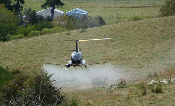
UAVOS has added the R22-UV unmanned helicopter to its agriculture unmanned aircraft portfolio for spraying for diseases, weed and pest control, and vegetation control.
The R22-UV is a manned Robinson-22 helicopter converted by UAVOS to an unmanned aircraft. (Photo: UAVOS)
The Agro-Drone R22-UV is equipped with a specially developed utility to deliver liquid chemicals — the spray system Simplex model 222.
The R22-UV drone is provided with a 100-liter tank for chemicals and can stay airborne for two hours. Weight of the system is 42 kilograms, boom span is 7 meters, and swath width is 14 to 16 meters.
UAVOS listed several advantages that could maximize the value of such a heavy UAV for farmers:
The R22-UV can be operated in the regions without airfields, under severe weather conditions and during night-time, in conditions with a high probability of risk for the pilot.
UAVs are excellent for operations in conditions of high humidity, where the use of ground equipment is impossible or difficult. Unlike heavy machinery, which cannot go into a field immediately after a heavy rain, UAV has no impact on the ground. Drone sprayers don’t touch the ground so there will be less soil compaction. This is when heavy machinery like tractors roll over the soil, pressing it down and damaging it. Farmers can fix this with plowing, but it can be harmful to the soil over a long period of time.
UAV implementation eliminates manual spraying with backpack sprayers, so workers don’t come into contact with hazardous chemicals.
UAVs also enable growers to spray their crops precisely and at will, which is critical for fighting herbicide-resistant weeds. Spraying is better. The rotor of an agricultural drone produces a huge downward rotation force, which promotes the pesticide droplets to penetrate the crop from top to bottom, which is conducive to the pesticide droplets evenly scattered in all parts of the plant, so that the spraying is accurate.
Unmanned aircraft can be used for spot spraying weeds with herbicides and are useful for spraying crops with pesticides. A spot-oriented approach based on preliminary analysis of digital images from robot cameras minimizes the cost of agrochemicals, reducing the chemical impact on soil, water, culture and, ultimately, on the consumer’s body, while achieving higher results of crop cultivation than with traditional approaches. The aircraft can be set on a predetermined GPS-defined route to fly over a field, dropping doses of pesticides, herbicides and fungicides as it flies.
“Precision agriculture is based on the use of valuable metrics to make farmers’ crop management efficient and optimized,” said Aliaksei Stratsilatau, CEO of UAVOS. “Validating-of-damage reports used to be on paper. So, unmanned aircraft help our customers to validate the veracity of reports so that we could come up with a comprehensive solution. Generally, agriculture is very complex and there are a lot of problems, but there are solutions available through the new technology.”
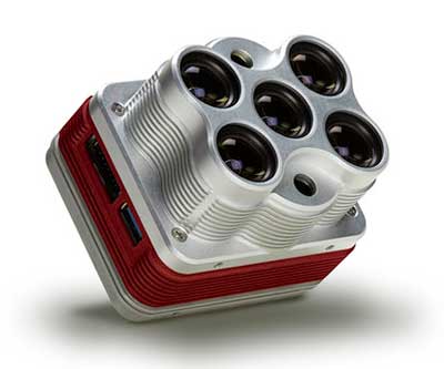
The Altum is a 3-in-1 sensor that combines thermal, high-resolution and multispectral imaging capabilities. (Photo: MicaSense)
The Altum sensor, offered by MicaSense, is designed for professional-grade agricultural drone mapping by enterprise and academic researchers. The Altum captures synchronized multispectral and thermal imagery, enabling aligned outputs for advanced analytics.
Altum’s multispectral imagers are the highest resolution integrated multispectral solution available for drones, allowing for detailed RGB outputs and advanced crop classifications.
Whereas before they had to fly multiple flights with multiple sensors, researchers, growers and service providers can now capture data for plant health, water stress mapping, phenotyping and more in one flight, with one sensor.
“The Altum design resulted from experience developing advanced analytics and understanding needs for advanced research,” said Justin McAllister, CTO and co-founder of MicaSense. “We realized the market is limited by time and cost constraints of owning multiple sensors and flying multiple passes over the same field. The goal of Altum is to simplify the workflow, and with synchronized capture, to provide results that can be correlated and quantified more easily.”
Altum includes MicaSense’s standard five-band configuration of multispectral bands (red, green, blue, near-infrared and red-edge) and an integrated Lepton radiometric thermal longwave infrared sensor from FLIR Systems, providing temperature measurement for every pixel of the scene for additional crop data and optimization.
https://youtu.be/Kdim4uol7S4
Expandable high-capacity USB 3.0 storage allows users to fly longer and cover more area without landing to swap storage. In addition, advancements in image capture rate enables faster flight speeds.
Users can process Altum data with industry standard software like Agisoft and Pix4Dmapper to generate an aligned, radiometrically calibrated six band (R, G, B, RE, NIR, T) geotiff, or access the raw data from Altum to process data themselves.
Included with Altum is DLS 2, the patent-pending next generation of the MicaSense Downwelling Light Sensor (DLS). DLS 2 allows for a more streamlined integration as it combines both the DLS and GPS into one product. In addition, through proprietary MicaSense technology, the DLS 2 will offer significantly better calibration for changing light conditions and better measurements over time.
Integrated solutions
Altum’s multiple interface options and open API gives users the ability to utilize Altum on a variety of platforms. In addition to the DJI SkyPort integration, Altum is integrated with drone offerings from the following companies (with more to come):
North America: Drone Nerds (U.S.), BirdsEyeView Aerobotics (U.S)., OmniView Tech (Canada), Sky Flight Robotics (U.S.), Blue Skies Drone Rental (U.S.)
Europe: 3D Target (IT), Globe Flight (DE), C-Astral (SI), Droneparts.de (DE), Ecobotix (DK), NaviGate (PL), Quantum Systems (DE)
DJI Payload SDK Program: Altum and RedEdge-MX for DJI M200 Series
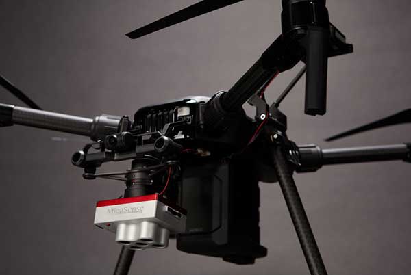
Through DJI SkyPort, MicaSense is able to provide seamless integration of its specialized sensors with DJI’s powerful line of enterprise drones, resulting in the MicaSense Altum and RedEdge-MX solutions. This provides users a high-quality drone and sensor combination they can rely on to capture quality data every time – with virtually no set-up time.
The DJI SkyPort integration for Altum and RedEdge-MX features plug-and-play integration for Altum and RedEdge-MX right out of the box, including power and quick connect/disconnect, and enhanced light calibration with MicaSense DLS 2.
“Solutions like the MicaSense Altum and RedEdge-MX demonstrate the value of integrating specialized industrial payloads to DJI’s powerful drone platforms,” said Jan Gasparic, head of Enterprise Partnerships at DJI. “By collaborating with solution providers, we are expanding the benefits of drone technology to more and more industries. In the case of agriculture, a specialized suite of sensors and more advanced level of analytics can truly bring tangible value to business workflows and decision making today.”
The Altum and SkyPort enabled RedEdge-MX and Altum are available today through the MicaSense website.
From growing crops to making movies, unmanned aerial vehicles (UAVs) are changing the way we work. UAVs — managed by unmanned aerial systems, or UAS — range from small indoor inspection units to giant Predator drones. They are streamlining how we manage mines and plants, deliver packages, and keep people safe. Read on to find out the latest in this skyrocketing market.
The unmanned aerial system (UAS) industry is in great shape! In the United States., the Federal Aviation Administration (FAA) appears to be helping commercial operations get off the ground, at least for those wishing to fly small unmanned aerial vehicles (UAVs).
Things are certainly hopping for unmanned aircraft in agriculture, mining and construction, facility inspection, newsgathering, movies and promotion. Package delivery is on the way, and, of course, defense is cooking with new innovations. Everywhere you look, a specialized drone or new application seems to appear that has good prospects for success.
One helpful aspect of today’s landscape for UAS operators in the U.S. is the FAA’s supportive approach to small UAS (sUAS) for commercial activities. After providing a regulatory framework with Part 107 rules, albeit with quite a few caveats that require a written waiver application, qualified drone operators are now able to fly their drones in many places — as long as they are below 400 feet, well away from airports, and nowhere near any restricted airspace.
Pilot qualification courses and proficiency testing are both readily available — at 676 commercial facilities across the U.S. according to the FAA website — and a successful online application process should result in a remote pilot’s certificate.
With a drone registered with the FAA, you can use the FAA’s B4UFLY mobile app to check if it’s safe to operate where you intend to. If it is, you can get approval in real time using the FAA’s Low Altitude Authorization and Notification Capability (LAANC) system. The FAA qualified LAANC to clear commercial drone operations, and the service is now provided by a large number of independent UAS service providers.
With the regulatory and approval path in place, it’s now possible for companies and individuals to earn a living with turn-key drone operations, providing services for many applications that have blossomed. There’s work to do beforehand, but it’s less arduous than for manned flight operations.
Let’s look at a few of the applications benefiting from the automation, enhancement and remote operations provided by UAVs as well as their on-board sensor suites and after-flight processing:
agriculture
mining and construction
facility inspection
newsgathering, movies and promotion
package delivery
defense
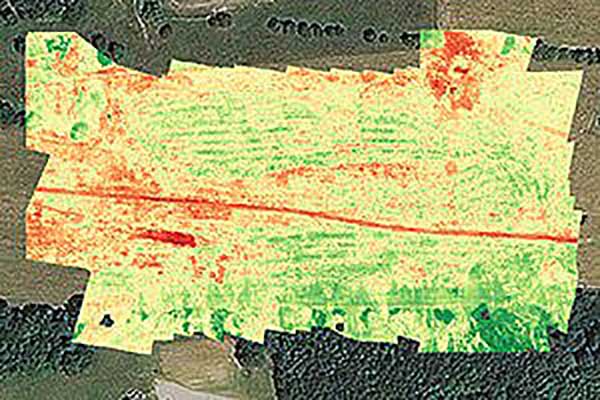
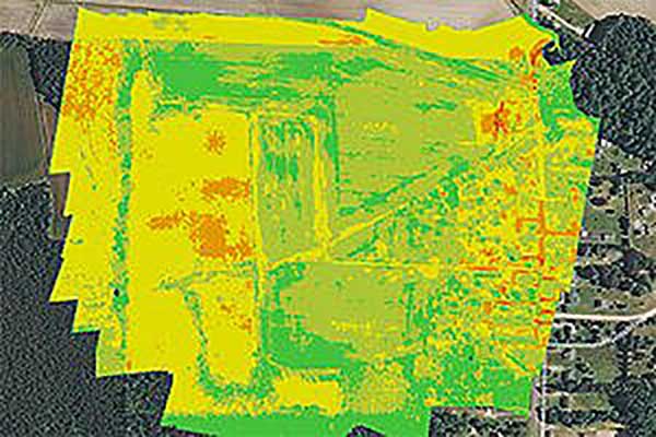
Crop health analysis: Precisionhawk’s software PrecisionAnalytics—Agriculture automatically generates georeferenced orthomosaics from data collected with drone sensors. (Map: PrecisionHawk)
Agriculture
Agriculture has readily adopted UAVs to monitor, control and improve overall crop growth rates — a part of what is known as precision agriculture. Drones carrying optical, thermal and laser scanning payloads gather stacks of information about the condition and rates of growth in fields. The information is then fed into various analysis tools. A picture emerges over time that indicates the health of crops. This enables farmers to generate a formulas for the nutrient and weed-reduction chemicals used for spraying at various times of the year. It’s a customized “prescription” for each growing area.
Continuing UAV overflights during the growing cycle monitor the effects of growing conditions and the effectiveness of treatments, providing more feedback that lead to even further improvements.
Smaller tech-savvy farms might run their own programs, supported by local agrochemical suppliers that may provide analysis services or sell analysis tools.
However, there has been a real growth in the number of companies that supply an entire turn-key package — supplying and flying drones, gathering data, running analyses and providing written and graphic output to support the farming operation.
Unmanned aircraft are truly an integral part of this approach, which might only have been possible because of semi-autonomous UAS and the evolution of compact sensors: UAV-mounted infrared, high-precision optical and lidar.
A sample prescription map. (Map: PrecisionHawk)
Mining and Construction
Any mine site is a busy — even chaotic — place to conduct a commercial business.
Drones provide a way for mining operations to:
quickly collect information to enable volume calculations;
provide relatively inexpensive site surveys; and
manage traffic and set up daily road layouts.
In effect, drones enable more rapid control of a complex and dynamic undertaking. Additionally, they improve safety. Ground surveyors no longer need to dodge huge operating machines and tumbling ore, or scramble around difficult terrain.
An autonomous drone can gather timely, georeferenced imagery that can be turned into a precise 3D model of the site. Site managers can have immediate access to details of the UAV survey. They can see the extent of existing deposits and know where to support further mineral exploration, receive estimates of stockpiles and tailing volumes, ensure that personnel and equipment are in the correct locations, and compare aerial video and photography day by day to check progress and for record-keeping. Drones can carry a wide variety of imaging and sensor packages including visual, infrared, hyperspectral, lidar, sonar and radar.
It’s also quicker. For instance, using the senseFly eBee fixed-wing drone, a full aerial survey of an 88-hectare site took four to five hours, with about half of that time spent placing control points. To achieve the same level of detail, terrestrial surveying would take a single surveyor two to three weeks.
Construction Operations. The construction sector uses the same drone data-capture techniques for site details, off-line analysis and results tabulation to manage operations of complex work sites. Compared to mining, change can be more intensive during a construction project, so drone surveys might be repeated more often.
Surveying and GIS. Using drones is an industry unto itself, with high-precision RTK GNSS in the air and on the ground, and specialized analysis tools for high-accuracy applications. The speed of data gathering is the principal benefit to an industry that continues to be essential in many sectors. Lower precision GIS for asset tracking and the like could become a subset of the applications and tools already discussed.
Facility inspection. Outdoor and indoor facility inspection is definitely benefiting from the automation that suitably equipped drones and customized analysis tools can bring to both regular and infrequent inspection tasks. The number of regular complex refinery inspections can be significantly reduced. Inspections will no longer interfere with production and will improve safety for inspection staff. For instance, flame stacks that burn off excess gases can be prone to failure, so regular inspection is essential. Using a drone for the task is clearly much safer than using personnel.
An offshore oil and gas construction platform vents gases to relieve pressure. Flame stacks such as these require regular inspection. (Photo: Oil and Gas Photographer/Shutterstock.com)
BVLOS for Pipelines and Rail
Automated pipeline and railway track inspection have both become possible as drones are used over much greater distances, thanks to beyond visual line of sight (BVLOS) operational approvals by the FAA.
For BVLOS, users first need a validated sense-and-avoid technology on the drone. Also required is proven radio telemetry with uninterrupted command-and-control of the vehicle during flight, and an independent ground-monitoring system that confirms how the drone maneuvers throughout the flight.
In the case of a BVLOS flight this summer along the Trans-Alaska oil pipeline, a Perimeter UAV manufactured by Skyfront flew about 4 miles, maintaining a constant above-ground altitude of 400 feet with multiple ascents and descents of 1,000 feet on 45-degree slopes. The long-range hybrid multicopter drone was equipped with Iris Automation’s computer vision collision-avoidance system and was monitored by
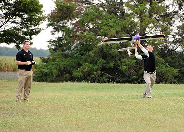
Launching a UAV for a BVLOS flight are (at left) Travis Balthazor, UAS flight operations manager, and Mike Kuni, UAS flight instructor/pilot, both of Kansas State University Polytechnic Campus. (Photo: KDOT, Division of Aviation)
Echodyne radars along the pipeline path, providing airspace situational awareness.
Another BVLOS operation built on the achievements of the Trans-Alaska pipeline trial has been authorized to fly a nine-mile linear inspection of power lines in rural Kansas.
Once again, the Iris Automation system will provide collision avoidance, but this drone also has an independent automated avoidance capability. This gives the drone the self-contained ability to fly around obstacles, so no ground radar or visual tracking is required.
Relieving the requirement for radar tracking or visual observers makes many new operations affordable. Previously, FAA Part 107 BVLOS waivers have all required visual observers or ground-based radar tracking — requirements that are not only expensive, but also restrict where flights are possible.
BVLOS operations like these demonstrate the cost-effectiveness of the technical solution, making long-duration, long-distance inspection using drones feasible.
Indoor inspection is becoming possible with specialized drones that circumvent the need to expose inspection staff to especially difficult facility environments, which in the past also required production shut-down to protect them. Thermal and visual sensors on swivel mounts enable protected inspection drones to fly into tight spaces — or even back out of tricky situations — and make visual records that may otherwise be virtually impossible.
Searching and recording inside containment vessels at the failed Fukushima nuclear facility may have been significantly advanced by using inspection drones.
Newsgathering, Movies and Promotion
All those panoramic, overhead, moving shots you see on the news, in movies and in ads used to be taken from a manned helicopter or fixed-wing aircraft. Now they are mostly taken by multi-copter drones with high-resolution cameras. This makes cinematography and newsgathering much more affordable, making these fields accessible by smaller operations. In the past, only large media groups could afford to rent a helicopter. And, of course, it’s much quicker to bring a UAV onto an incident site, operated by a crew on the ground.
You’ll need FAA approval to use a drone for commercial newsgathering purposes, or find a suitable qualified UAV and operator. After gaining FAA qualifications, news people are also taking on the job, buying and flying the equipment and managing the video-processing software themselves.
Others using drones for similar purposes are movie makers, producers of TV commercials and real estate agents, to name a few.
Delivery by Drone
The ultimate objective of many internet suppliers is to deliver goods that were just ordered within minutes of the order being placed. This is a pretty big objective. It requires a whole network of “fulfillment centers” in and around many cities, a massive purchasing and goods movement capability to keep these centers stocked, and a system that delivers to the end-customer. Currently, we mostly have manned panel trucks of various flavors handling that last step of the delivery process, with real people reading the notes we put on the porch about where to leave our package if we’re out.
Order and Receive. The next wave of delivery changes are expected to include drones carrying your package from the fulfillment center to your backyard. Amazon is looking for approval to begin trials with its larger 88-pound MK-27 Prime Air delivery drone, initially in sparsely populated areas. The MK-27 is equipped with intelligent sense-and-avoid capability, flying around any obstacles it encounters in flight and even during delivery.
UPS is also hoping to get to qualification of its own UAS delivery system by the end of this year, to the same standards that manned aircraft delivery systems are certificated.
Medical Deliveries. Many other trials are underway, especially involving medical deliveries and support. In Africa, trials are underway in Ghana, Malawi and Rwanda. UPS recently proposed a medical supplies delivery service using drones in North Carolina. Many companies that claim expertise in medical deliveries are operating drones.
Food on the Fly. Restaurant food delivery services have seen an upsurge in popularity. It seems likely that soon you’ll be able to order and receive lunch really quickly by drone food delivery services. Ground robot food deliveries at George Mason University are already a huge hit! Uber-Eats is experimenting with drone food deliveries, and 17 drone delivery routes have already been approved in an industrial park in Shanghai.
Meanwhile, Bell has flown its autonomous pod transport (APT) 70 near its base in Fort Worth, Texas, for the first time. The APT 70 can carry a 70-pound package load at over 100 mph, far faster and farther than existing drone delivery systems.
Bell is aiming for package delivery and critical medical transport for disaster relief for APT type drones. It is also participating in the NASA SOI program along with General Atomics’ SkyGuardian.
Drones are a new tool. The UAS industry will continue to change and adapt these products and this technology in as-yet-unthought-of ways. It’s an exciting time, and right now, there seems to be no end in sight.
For a look at drones in the defense industry, see Murfin’s article “Defense in front of UAV development,” published in September’s Professional OEM + UAV newsletter.
Guest column by Brian Wynne AUVSI President and CEO
Brian Wynne, AUVSI president and CEO
A recent analysis found that just 10 percent of the unmanned aircraft systems (UAS) included in the Unmanned Systems and Robotics Database maintained by the Association for Unmanned Vehicle Systems International (AUVSI) can operate beyond the visual line of sight (BVLOS) of its operator.
While the technology for BVLOS operations has existed for years, under current federal regulations, only the military is permitted to use it. The absence of federal regulation allowing BVLOS operations hinders the full value and benefits that the UAS industry has to offer.
Regulations that provide guidance and rules for operating unmanned systems are necessary for the industry’s advancement. Earlier this year, the Federal Aviation Administration (FAA) issued a proposed rule for UAS operations over people, and the UAS community is eagerly anticipating the agency will offer an additional rule requiring UAS to be equipped with remote identification.
“Remote ID is a crucial next step to gain the confidence of federal defense and security agencies, manned aviation users and the public.”
However, the rulemaking process for remote ID has been delayed by the FAA twice this year and is now slated to be released in December. The need for remote ID cannot be overstated, as the advancement of the UAS industry depends on identifying and tracking UAS flying in the airspace.
Furthermore, remote ID is a crucial next step to gain the confidence of federal defense and security agencies, manned aviation users and the public. With this confidence, UAS can further integrate into the national airspace to perform important BVLOS operations such as inspection of utility rights of way, widespread search-and-rescue missions, and package delivery.
A clear, national regulatory framework and the support of the federal government is needed to drive the adoption of unmanned systems technology and its applications. Currently, the UAS industry is working with our government partners on remote ID and tracking standards, but we recognize that more needs to be done and at a faster pace than the regulatory process allows. That is why the UAS industry is stepping up to explore near-term solutions before remote ID regulations are finalized and published.
In May, AUVSI and the Airports Council International-North America commissioned a Blue Ribbon Task Force on UAS Mitigation at Airports. The task force is working to refine procedural practices and provide a policy framework to address the timely and critical issue of incursions by unauthorized UAS at airports and how best to mitigate this threat, including industry and government recommendations for remote ID. The task force will release a report this year.
Applications of unmanned systems aren’t limited by technology or imagination; they’re only limited by regulations. We need a streamlined regulatory environment that allows for the safe deployment of unmanned systems into our nation’s transportation infrastructure so we can begin to reap the full benefits of this technology.
The new GSAGNSS Market Report is now available for download. The report provides a comprehensive overview of the GNSS market and the global industry, as well as a focus on EGNSS differentiators and synergies with Copernicus, according to the publisher, the European GNSS Agency (GSA).
Areas covered include:
A general overview of the GNSS market and a global industry overview.
Analysis of macro-trends affecting GNSS, including climate change and the circular economy, big data, artificial intelligence, the silver economy, cyber security and the sharing economy.
A review of the main GNSS market segments in detail, including trends and developments, forecasts for future shipments, revenues and the GNSS installed base, and a look into GNSS user requirements.
GNSS in Space. This year, the report features the “Editor’s Special: GNSS for NewSpace,” a section that introduces GNSS receivers in satellites and their relation to the evolving space sector.
GNSS market monitoring is a key activity of the GSA. Market monitoring supports GNSS stakeholders in their planning and decision-making, and offers a clear tool to understand GNSS trends and evolutions.
Since its launch in 2010, the GSAGNSS Market Report has become the go-to-source for information on the dynamic, global GNSS market segments and applications.
A committee of the U.K.’s House of Commons issued a report calling for greater drone regulations, including registration, drone ID transmission and geofencing around sensitive locations.
In its summary, it recalls drone sightings at Gatwick Airport in December 2018, which caused “significant disruption and highlighted the need for further recognition of the substantial rise in the purchase and use of commercial and civilian drones more widely.”
Restricted Airspace
The report calls for more studies, such as on airport/drone collisions. It recommends that the government complete an assessment of the risks that drones pose to manned commercial aircraft and publish the findings by the end of 2020.
“The committee is concerned that there is no agreed position on the likely consequences of a drone-airplane impact,” the report says.
The committee also recommends temporary drone flight restriction zones around helicopter landing zones and said the government should consider geo-fencing as a compulsory measure around prisons and high security areas.
“We recognise the importance of extending Flight Restriction Zones to five kilometres. However, these restriction zones are not clearly or consistently enforced,” the report states. “The lack of a standardised process results in inconsistent denials and permissions being granted to those applying. This is unacceptable.”
“The government should commission the production of a standardised and unified system through which drone operators can request access to Flight Restriction Zones. This could be achieved by working with National Air Traffic Services on its development of an Airspace User’s Portal. This should be completed no later than summer 2020.”
Drone Registration
The report recommends that the government begin a UAV registration system, enabling identification of lawful drone operators. Those registering would also have to pass a knowledge test. It also recommends that drones be “electronically conspicuous” with some form of electronic ID within two years. Both ID and geofencing should be standard in drones, the report said, with penalties for disabling these features.
If a drone user doesn’t register, “We recommend a sliding scale of penalties for failure to register, starting with a warning, and culminating in a fine and a prison sentence,” the report states.
BVLOS and UTM tech testing
A beyond-visual-line-of-sight (BVLOS) testing facility should be established so that unmanned traffic management (UTM) systems and related technologies can be tested, the report recommends.”Clear plans should be set out for this as soon as possible and further testing should begin no later than Summer 2020.”
The report concludes, “The government should produce a white paper by summer 2020 that outlines the vision for how drones will be integrated into UK communities over the coming years.”
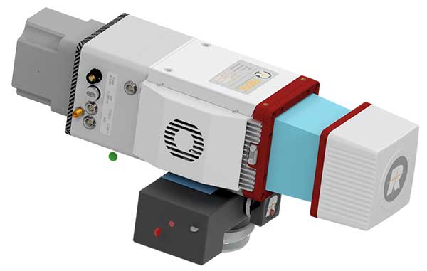
The miniVUX-2UAV airborne laser scanner. (Photo: Riegl)
The Riegl miniVUX-2UAV is a lightweight airborne laser scanner designed specifically for integration with unmanned aerial vehicles and systems.
Riegl added the new miniaturized UAV sensor to its portfolio of professional solutions for UAV-based surveying.
The sister type of the miniVUX-1UAV sensor, the miniVUX-2UAV offers 100 kHz and 200 kHz PRR. With the 200-kHz PRR, the sensor provides up to 200,000 measurements per second, and thus a dense point pattern on the ground for UAV-based applications that require the acquisition of small objects.
The Riegl miniVUX-2UAV makes use of Riegl waveform lidar technology, allowing echo digitization and online waveform processing. Multi-target resolution is the basis for penetrating dense foliage, and the wavelength is optimized for the measurement of snowy and icy terrain.
In addition to the stand-alone version of the miniVUX-2UAV, Riegl also offers fully-integrated solutions.
World View, the stratospheric exploration company, has reached an important milestone representing a key step toward persistent and navigational stratospheric flight.
After achieving the goal of more than 30 days aloft with full navigational control, the Stratollite completed its 32-day mission over the weekend, showcasing its enhanced long-duration flight capability.
Before this mission, the longest Stratollite flight was 16 days, achieved in June 2019. This mission moves World View closer to scaled commercial operations, making the unique data and information sets it can provide available to commercial and government Earth-observation and remote-sensing customers around the world.
Notable accomplishments from the mission:
Executed four continuous days of station-keeping (mission objective) with an average distance of 20 km from the first predetermined target location, followed by an intentional navigation to the second station-keeping target location 1,230 km away.
Achieved 2.5 days of continuous station keeping at the second station-keeping target with an average of 40 km from the second target location.
Averaged an altitude of 19.5 km during both station-keeping exercises.
Traveled more than 11,200 km during the mission, covering Arizona, Utah, Nevada, Colorado, New Mexico, Texas, Oklahoma, Nebraska, Iowa and Kansas.
Demonstrated complete navigational control during the mission from World View’s remote Mission Control in Tucson, Arizona.
The total mission duration was 32 days, 5 hours and 14 minutes
Executed more than 1,000 trajectory-control maneuvers over the entire mission.
“This is another encouraging milestone for the team and our customers that confirms we are on the right track,” said Ryan Hartman, World View president and CEO. “It sets the stage for a challenging set of missions ahead of us as we continue to push the envelope and demonstrate the ability of the Stratollite to meet customer requirements.”
World View’s flight operations team landed the Stratollite at a predetermined landing zone in Iowa on Saturday, Sept. 28, to conclude the mission. The system landed on command, was recovered, and will be refurbished for reuse on future missions.
World View will continue to increase the cadence of its Stratollite flight operations. The company plans to launch multiple missions focused on demonstrating optical imaging and synthetic aperture radar sensing systems with further enhancement of station-keeping and navigational performance.
About the Stratollite. World View’s Stratollite is a long-endurance stratospheric flight vehicle capable of station-keeping over areas of interest for remote sensing and communications.
The craft can travel 95,000 feet above the Earth. World View is already routinely flying payloads to the edge of space for a wide variety of government, commercial, and education customers.
World View’s proprietary altitude-control technology allows it to harness stratospheric winds to steer the Stratollite to and from desired locations and loiter above them for long durations.
Stratollites can carry a wide variety of commercial payloads (sensors, telescopes, communications arrays, etc.), launch rapidly on demand, and safely return payloads back to Earth after mission completion.
Among its wide variety of uses, the Stratollite will help researchers greatly advance knowledge of planet Earth, improve our ability to identify and track severe weather, and assist first responders during natural disasters.
Terra Drone Corporation has launched a new UAV and artificial-intelligence (AI)-based solution designed for maintenance of power transmission and distribution equipment.
The solution was developed based on market gaps identified after inspecting more than 90,000 kilometers of power lines beyond visual line of site (BVLOS) throughout the world.
Acquired data is automatically processed and analyzed by artificial intelligence algorithms trained to detect crossovers at the bottom of transmission lines, buildings and construction machinery.
The system identifies rust on bolts, loosening and missing tower parts, bird’s nests and more. It then generates a smart report highlighting areas that require action. The error (identified anomaly) detection system is accurate up to 92.5%.
The algorithm for an area is developed through a process identifying anomalies in a training data set of 1,500 images. This allows for a custom solution to be created for the end client where all pertinent anomalies are identified and reported.
The development and training of the algorithm only need to be completed once for a particular type of asset and can be implemented easily at different locations on similar assets.
With such a high-precision algorithm, the productivity of AI processing allows for fast actionable results to be provided to clientele. Clients also have the ability to identify the appropriate security protocols for data storage in either a cloud-based or on-premises storage environment. These protocols can then be implemented in a custom client-specific solution.
Loosening and missing tower parts identified by high-accuracy detection system (Photo: Terra Drone)
Power transmission and distribution companies must conduct periodic inspections of power line infrastructure to ensure reliable electric power distribution, although the conventional methods of deploying ground staff or low-flying helicopters to complete the inspections, they are typically cost-prohibitive. Conventional helicopter and boots-on-the-ground service also pose HSE concerns with low flying helicopters and people working in the field. UAV service and AI inspection can aid in minimizing HSE concerns by reducing the number of workers in the field and eliminate low level manned helicopter missions.
This solution has been built from ground up with the aim to simplify and streamline the maintenance work for transmission and distribution facilities.
The United States Federal Aviation Administration (FAA) has awarded air carrier and operator certification to UPS Flight Forward, an unmanned aircraft system (UAS) delivery company.
Through the DOT’s UAS Integration Pilot Program, the FAA has now approved a Part 135 operating certificate for UPS Flight Forward. This allows the company to perform revenue-generating package delivery activities within federal regulations.
UPS Flight Forward may now operate multiple drones under one certificate. Under Part 135, the company can deliver vital healthcare supplies including by flying beyond visual line of sight.
The UPS subsidiary immediately launched the first drone delivery flight by any company under Part 135 Standard at WakeMed’s hospital campus in Raleigh, N.C. That flight, using a Matternet M2 quadcopter, was flown under a government exemption allowing for a beyond-visual-line-of-sight (BVLOS) operation, also a first in the U.S. for a regular revenue-generating delivery.
UPS said it has proven the need for drone delivery in healthcare operations, where the shortest time in transit can improve efficiency and help healthcare professionals better serve patients.
The medical delivery program at WakeMed is the result of testing conducted by UPS and Matternet in August of 2018 as part of their participation in the UAS Integration Pilot Program (UAS IPP).
UPS partnered with Matternet to launch its healthcare delivery service on the WakeMed campus. The revenue-generating service demonstrated the business case for drone delivery of medical products and specimens.
Now, with its Part 135 Standard certification, UPS is ready to build on this application and expand to a variety of critical-care or lifesaving applications.
Photo: UPS
“This is history in the making, and we aren’t done yet,” said David Abney, UPS chief executive officer. “Our technology is opening doors for UPS and solving problems in unique ways for our customers. We will soon announce other steps to build out our infrastructure, expand services for healthcare customers and put drones to new uses in the future.”
The company will initially expand its drone delivery service further to support hospital campuses around the country, and to provide solutions for customers beyond those in the healthcare industry.
Part 135 Standard certification enables UPS to integrate drones into the UPS logistics network, creating potential for new applications in many industries. The company has a long-term plan with milestones that include:
expansion of the UPS Flight Forward delivery service to new hospitals and medical campuses around the country.
rapid build-out of ground-based, detect-and-avoid (DAA) technologies to verify drone safety, while enabling future service expansion.
construction of a centralized operations control center.
regular and frequent drone flights beyond the operator’s visual line of sight.
partnerships with additional drone manufacturers to build new drones with varying cargo capacities.
adding new services outside of the healthcare industry, including the transport of special commodities and other regulated goods.
“UPS is committed to using technology to transform the way we do business,” said Scott Price, UPS chief transformation and strategy officer. “UPS’s formation of a drone delivery company and application to begin regular operations under this level of certification is historic for UPS and for the drone and logistics industries.”
As a participant in the U.S. Transportation Department’s Unmanned Aircraft Systems Integration Pilot Program, the North Carolina Department of Transportation (NCDOT) partnered with UPS Flight Forward. As the operator, they have been engaged in delivery of healthcare supplies around a major hospital campus in Raleigh, North Carolina. The flights have focused on the delivery of blood for potentially life-saving transfusions, as well as other medical samples for lab work.
The company demonstrated that its operations met the FAA’s rigorous safety requirements to qualify for an air carrier certificate. This is based on extensive data and documentation, as well as test flights.
The drone operations management platform provides information on 3D vertical structures and obstacles, and access to digital airspace, to improve drone flight safety.
Skyward’s drone airspace maps provide airspace data combined with essential ground intelligence including 3D views of key structures, transmission lines, and more than a million vertical obstacles.
The platform also provides access to LAANC, the Low Altitude Authorization and Notification Capability program provided by the U.S. Federal Aviation Administration.
Drone pilots in the field need to know how the surrounding area, including infrastructure, could affect flight, and Skyward offers this critical safety data to all users.
“Showing airspace is important, but it’s only part of the picture. The more intelligence that is available to understand how an area will affect the flight, the less risk a pilot has in the field,” said Mariah Scott, president of Skyward. “Skyward Airspace Intelligence is the only solution that provides easy-to-understand data for things like transmission lines, runways, over a million vertical obstacles, and a 3D view of key structures. It’s the next best thing to physically being in the field.”
In addition to comprehensive airspace information, the following data is now available for situational awareness:
Vertical structure obstacles (over one million structures identified from the FAA and FCC databases)
Major power transmission lines
Airports
Runways
Heliports
U.S. and Canadian National Parks
Stadiums
Hospitals
Schools
Pedestrian walking paths
Skyward Airspace Intelligence is part of a complete workflow that enables pilots mitigate weather, environment and business-specific risks.