Qianxun Spatial Intelligence Inc., a high-precision positioning service provider, and u-blox are joining forces to deliver high-precision positioning solutions to the Chinese market.
By coordinating their product offerings, they seek to meet growing demand for increased positioning accuracy for mass-market applications. Some of the areas driving up demand for high-precision positioning services in China are internet of things (IoT) tracking devices such as those used on shared bikes, as well as automotive, UAV and robotic vehicle applications.
u‑blox is bringing to the partnership its high-precision GNSS receivers. Its u‑blox F9 multi-band positioning platform uses integrated real-time kinematic (RTK) technology to process the high-precision positioning correction data provided by Qianxun SI, delivering down to centimeter-level positioning accuracy for wide-ranging applications. It enables even faster and more robust performance by leveraging a greater variety of GNSS signals.
Two major advancements have enabled sub-meter-level positioning accuracy for mass-market applications. The first is modern GNSS correction services that constantly monitor GNSS signals to determine positioning errors caused, for example, by atmospheric distortions, and wirelessly transmit correction data to compensate for these errors to millions of GNSS devices. The second is a new generation of small, power-efficient, and affordable GNSS receivers that are able to use the correction data to achieve such high levels of accuracy.
Qianxun SI, a high-precision positioning service provider, has already laid the groundwork for the large-scale expansion of high-precision positioning in the IoT era, the company said. Based on BeiDou, which is compatible with GPS, GLONASS and Galileo, Qianxun SI’s high-precision positioning service is built on the nationwide ONE Network, composed of more than 2,000 Continuously Operating Reference Stations (CORS) and using proprietary algorithms. It offers vehicles and other applications a range of 24/7 high-precision positioning services in most regions of the country.
By the end of 2018, Qianxun SI’s dynamic centimeter-level service will cover the entire mainland of China, the company said.
“We are delighted to cooperate with u-blox to provide users with high-precision positioning solutions that are user friendly and affordable,” said Jinpei Chen, CEO of Qianxun SI. “I believe our high-precision positioning technology is a key enabler of IoT development, and the cooperation with u‑blox will accelerate the go-to-market process of the technology in an extensive range of industrial and automotive market applications.”.
“This collaboration is a genuine win-win for all involved in that it allows us to develop high-precision solutions that will foster innovation across markets,” said Thomas Seiler, CEO of u-blox. “Partnering with China’s leading GNSS correction service provider allows u-blox customers to bring cutting edge applications to the China market in the shortest possible time.”
“We know our diverse new partners will help us address a broad range of complex drone integration challenges,” said FAA Acting Administrator Dan Elwell. “The fields that could see immediate opportunities from the program include commerce, photography, emergency management, public safety, precision agriculture and infrastructure inspections.”
The 10 programs are:
Choctaw Nation of Oklahoma, Durant, Oklahoma
City of San Diego, California
Innovation and Entrepreneurship Investment Authority, Herndon, Virginia
Kansas Department of Transportation
Lee County Mosquito Control District
Memphis-Shelby County Airport Authority
North Carolina Department of Transportation
North Dakota Department of Transportation
City of Reno, Nevada
University of Alaska-Fairbanks
Over the next two and a half years, the selectees will collect drone data involving night operations, flights over people and beyond the pilot’s line of sight, package delivery, detect-and-avoid technologies and the reliability and security of data links between pilot and aircraft.
The data collected from these operations will help the FAA:
craft new enabling rules that allow more complex low-altitude operations,
identify ways to balance local and national interests related to UAS integration,
improve communications with local, state and tribal jurisdictions,
address security and privacy risks, and
accelerate the approval of operations that currently require special authorizations.
First announced in October 2017, the White House initiative partners the FAA with local, state and tribal governments, which then partner with private industry to safely explore the further integration of drone operations.
The program will help tackle the most significant challenges to integrating drones into the national airspace and will reduce risks to public safety and security.
Brian Wynne, president and CEO of the Association for Unmanned Vehicle Systems International (AUVSI), issued the following statement on the announcement of the participants selected for the FAA’s Unmanned Aircraft Systems (UAS) Integration Pilot Program:
“The participants selected for the FAA’s UAS Integration Pilot Program represent a commitment by governments at all levels to safely and efficiently integrate UAS into the national airspace. As more and more businesses and public institutions embrace UAS, it is more important than ever to have a process in which states, municipalities and tribal governments can provide input on federal policy without infringing on the U.S. government’s jurisdiction over the airspace.
“The data the participants will collect on UAS operations will help shape a national UAS policy framework, including for a UAS traffic management system and expanded UAS operations such as flying over people or beyond line of sight,” Wynne said. “We look forward to seeing the results of their work and the contributions these groups will make to keeping our skies safe.”
According to AUVSI, the potential economic benefit of drones in the nation’s air space, in less than a decade, is estimated at $82 billion and could create 100,000 jobs.
Drone maker DJI issued a statement saying it looks forward to the advances in drone regulatory procedures that will be enabled by the innovative proposals offered by the 10 state, local and tribal governments.
“Regulators and governments want to develop safe systems that encourage the beneficial uses of drones while addressing concerns about them, and today’s announcement is a major step forward in this effort,” said Brendan Schulman, DJI vice president of Policy & Legal Affairs. “By connecting state, local and tribal governments with industry partners and federal support, the Integration Pilot Program makes it easier to find ways for American businesses, governments and individuals to put drones to good uses all across the country.”
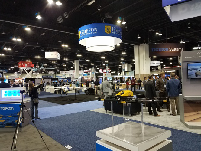
AUVSI Xponential was a big show once again — 8,500 attendees, more than 600 exhibitors, 200 educational sessions and 400 speakers. The show floor was huge as usual, with virtually every kind of UAS product and service imaginable for inspection at small, large and larger booths or display areas.
The morning kick-off presentation on Tuesday was enthusiastic about the coming large-scale adoption of drones and associated robotic technology, with a couple of real-time examples — driverless vehicles at Babcock Ranch in Florida and drone supply deliveries for humanitarian aid in Rwanda.
A view of show floor.
However, there still remain a number of barriers to wide-scale integration of drones into daily life from a regulation perspective, as Steven Bradbury, general counsel of the U.S. Department of Transportation, pointed out — while at the same time also indicating that the Federal Aviation Administration (FAA) has granted hundreds of waivers where the safety case has been adequate for lots of commercial UAS operations.
Most of the major GNSS players were exhibiting at the show, so we focused on gathering their news while also collecting a flavor of the many drone system suppliers in attendance.
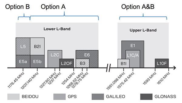
U-blox introduced its new ZED-F9P multi-band, multi-constellation chip — with GPS, GLONASS, Galileo and BeiDou signal reception and processing and on-chip multi-band RTK with fast convergence times — promising centimeter-level accuracy and low 85 mA (4x GNSS) power consumption in a 17 mm x 22 mm package.
ZED-F9P signals: coverage added in two stages. Option A – available now. Option B – available Q2/2020.
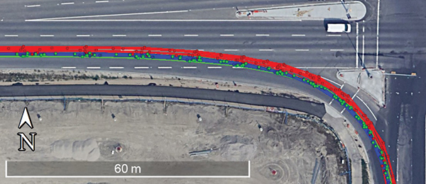
Initial urban testing in Finland in challenging conditions has indicated RTK performance at 9 cm 94%, with high availability, short convergence times (<10 seconds) and fast reconvergence. This kind of performance is apparently initially targeted at automotive applications — u-blox is a member of the Sapcorda automotive group — and is forecasting samples for this July, with production beginning before the end of this year.
The NovAtel tagline for the show was “Assured PNT,” which matches many U.S. and International agency objectives — this was accompanied by several announcements for both commercial and government agency products and applications.
The integrated E1 package includes NovAtel’s SPAN technology, which optimizes positioning and attitude performance during extended GNSS outages. Both new PwrPak enclosures come with the Interference Toolkit advanced interference detection and mitigation capability.
With most UAVs, the electronics on the airframe can produce a disruptive internal interference environment, and can lead to potential problems for the integration of sensitive GNSS. To help overcome this issue, NovAtel has released the OEM7600 receiver board in an extremely small form factor, enclosed with protective shielding to reduce the effects of emissions from nearby electronics.
The 7600 comes with 555 channels, multi-frequency/constellation positioning; L-band support for TerraStar corrections; serial, USB, CAN and Ethernet interfaces; advanced interference detection and mitigation features; RTK; GLIDE and Steadyline firmware options with 20-g vibration rating and the option to add integrated SPAN GNSS + inertial.
NovAtel also announced Inertial Explorer Express, which provides the same core processing and utilities as Waypoint Inertial Explorer software for applications including unmanned aerial vehicles (UAVs) and smaller projects. Inertial Explorer Express will produce centimeter-level position and attitude solutions for lidar, camera and other sensor data with faster processing times and reduced complexity.
On the government/agency business side of the house, NovAtel has been quite successful with the GAJT antenna, which includes integrated anti-jam technology. GAJT is in use operationally and has been shipped to 16 allied nations around the globe, with the latest success being with the artillery Observation Post Vehicles (OPV) for the Canadian Army.
The NovAtel GAJT-710ML GPS anti-jam antenna.
The Type 26 Frigate of the British Fleet will use NovAtel anti-jam technology. (Photo: BAE Systems)
Canadian OPVs are used on the front-line of combat, so its essential that their location and timing information should not be compromised by enemy jammers. The NovAtel GAJT is readily retrofitted to existing vehicles to provide the necessary jamming defense needed by front-line forces.
Previously, NovAtel also announced the selection of GAJT for the UK fleet of Type 26 Frigates – providing essential anti-jam protection for its onboard navigation system.
MB-Two module by Trimble.
Chris Wheeler and Omar Subra were good hosts when we visited them at the Trimble booth — Chris first made a YouTube video for GPS World (see below) and then gave me some insights into what’s new.
Basically, the OEM line has rolled over new versions of almost all individual receiver boards, with the addition of the BeiDou B3 frequency, capability for RTX PPP (precise point positioning) corrections, the addition of new constellations and inertial integration options.
An updated MB-Two receiver module can be configured for single frequency GPS through to dual frequency GPS, GLONASS, QZSS, Galileo and Beidou, uses RTX PPP and has an improved RTK engine for cm positioning from a base-station, or from over-the-air RTK corrections, or provides relative RTK against a moving base.
A typical Trimble application could include capturing an Insitu ScanEagle UAV in a difficult shipboard multipath environment with integrated GNSS-inertial, UAV navigation and control, UAV payload stabilization, or providing a “truth-system” for autonomous unmanned ground vehicles.
Since last year when Trimble introduced a “cell-phone” software receiver application, one useful application could have involved an insurance company using a “pocket-carried” antenna (with integrated RF) for field incident assessments. The cell-phone software license would be transferable to other assessors in the department, while a few pocket antennas are available for the whole assessment crew. This saves purchasing a whole load of hardware, and being limited to where the functionality can be moved or deployed. Everyone has a cell phone, and the relatively inexpensive antenna/RF can be available to all needing them.
Watch this video to learn about Trimble’s latest products, including its BD990 and BD992 GNSS receiver boards.
Trimble is also ramping up its OEM customer service and repair capabilities to improve turn around for multiple customers and applications in the field. Improved results are beginning to help customers and its OEM business, while increased R&D investment is expected to put new products into the field in the fall.
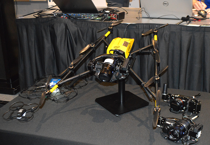
This year Intel’s emphasis continued to be on how to manage the huge amount of data that high-precision visual and multi-spectral cameras are gathering by UAVs carrying out asset inspections for their customers. The Intel view is that this data is useless to an end-user unless it is interpreted and presented in a format that can be readily understood and used for the purpose it was intended.
Let’s say a company operates 75 drones inspecting installations it owns or operates across several states, and that 50 GB of data is the nominal amount of data each drone collects on each mission. That means that nearly 4 TB of data could be collected daily if all 75 drones operate at once. More likely, over 1 TB daily shows up in a central location — a huge amount of unprocessed data.
In a live demonstration, Intel showed how a typical installation inspection — by a drone taking high-resolution still photos at a remote location – could be collected and managed. Once in an Intel processing environment, the data quickly became visual format in 2D or 3D, and could be accessed remotely by an inspection team, saving significant travel costs and time to actionable results.
Intel also promised to soon exceed its record at the Pyeongchang Winter Olympics for the number of drones flown at once — currently set at 1,218 drones. The company’s next target is for a light display using 1,500 multi-colored drones.
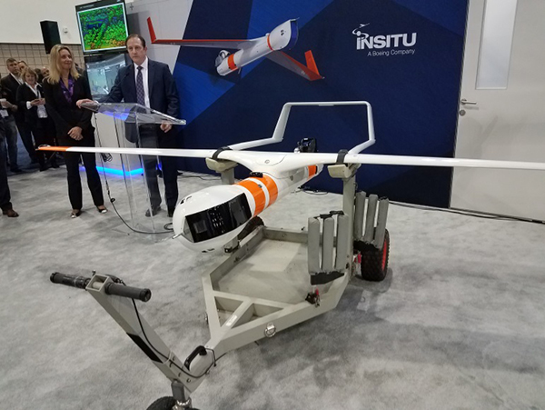
Insitu CEO Esina Alic
Insitu held a media event at the show to announce its ScanEagle-3 drone system. Esina Alic, the new Insitu CEO, led a team who introduced and then unveiled the new commercial-standard ScanEagle variant.
This new variant has grown out of 20 years of experience and 15 years of working with the FAA to enable integration of drones into the U.S. National Airspace System (NAS). The ScanEagle-3 (SE-3) has been rebuilt with the objective of developing a certifiable vehicle with increased payload and endurance capability that is free of any ITAR restrictions — allowing export without restrictions to the rest of the world.
Insitu unveils the ScanEagle-3 is at Xponential 2018.
SE-3 features include:
Significantly increased (x2) payload
Still provides for full integration of all existing payloads
Commercial, non-ITAR product for the global market
Long-endurance platform
Service contracts available
Product release in Q2 2019
Fully compatible with existing launch and recovery systems
Around ~100 lb without payloads
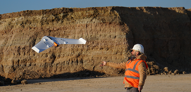
ScanEagle variants were used in emergency response to the California wildfires at Santa Rosa and Medicina, gathering real-time information for fire-line combatants.
ScanEagle helped fight these wildfires using High Accuracy Photogrammetry (HAP) sensors. Military-grade electro-optical (EO) cameras during daylight and infrared (IR) cameras for night-time imaging extended the time available for tracking fire lines. Penetrating smoke or darkness, these UAVs gathered video and still images that were used to create geo-referenced, high-resolution digital fire progression and suppression maps to guide firefighting on the ground.
This small overview of Xponential 2018 attempts to provide a flavor of the breadth of activity we saw at the show last week. A good portion of this has also been captured through short videos published on the GPS World website, along with news articles.
There is more to come, with a report to follow from the show on Septentrio’s new product releases, Spirent’s GNSS simulation demo, DJI’s overview of drone products featured at the show, CyPhy Works tethered drones, Swift’s announcement of its Skylark correction service trials, Hemisphere’s new Vector Smart Heading Antenna, and Harxon’santennas for drones.
A big show to cover, that’s for sure! It’s a good sign that people were perhaps talking more business than in previous years and a sign that the UAS industry is perhaps moving into its next growth phase.
The UX11 is a lightweight, beyond-visual-line-of-sight (BVLOS)-ready fixed-wing mapping drone.
The combination of on-board processing capabilities, real-time control and centimeter-level precision make it a cost-effective solution for large area surveying and mapping, Delair said.
The Delair Septentrio UX11 mapping UAV. (Image: Septentrio)
By employing the latest high-specification photographic, sensor and communications elements, Delair has kept the weight of the UX11 — including payload — down to 1.4 kilograms (3.1 pounds). Among other design innovations, this allows the UX11 to cover 200 hectares (500 acres) in a single one-hour flight, delivering mapping with ground sample distances below 1 centimeter per pixel (0.4 in/px) with accuracy down to 1.27 cm (0.5 in).
A 3G/4G network link to the UX11 allows the operator to assess in real time the quality and overlap of images during flight and make any necessary adjustments to the settings of the integrated camera. This enables operators to collect as much aerial intelligence as possible in a minimum number of flights.
The UAV also features BTOL (bird-like take-off and landing) for steep-climb take offs and descents in confined areas.
The AsteRx-m2 delivers high-precision multi-frequency quad-constellation GNSS measurements for PPK (post-processed kinematic) for only 28 grams, and consumes very little power.
The combination of high-quality camera images and GNSS measurements from the AsteRx-m2 allows Delair to offer its users PPK survey-grade ground precision down to 1 centimeter. With Delair’s PPK software, powered by Septentrio’s GeoTagZ PPK library, users only pay for the precision they need and on a flexible pay-as-you-go basis.
“With the AsteRx-m2, we can offer wide-area coverage at ultra-high precision,” said Chase Fly, geospatial product manager at Delair. “The Delair UX11 sets a new standard of efficiency, cost and quality in a long-range UAV platform. The drone itself is truly state-of-the-art in its design and construction, and it enables industry-leading performance and flight range, as well as streamlined maintenance, advantages that all reduce costs.
“The integrated processing capabilities are able to ensure image quality in real time and provide users with accurate results that shape critical operational decisions and strategies,” Fly said. “And it’s designed for flexible use in a variety of conditions and use models, further lowering TCO.”
The AsteRx-m2 features Septentrio’s proprietary GNSS+ suite of positioning algorithms to convert difficult environments into good positioning:
LOCK+ technology to maintain tracking during the heavy dynamic vibration typical of UAV flights
APME+ to combat multipath
IONO+ technology to ensure position accuracy during periods of elevated ionospheric activity.
The AsteRx-m2 also features AIM+ interference mitigation and monitoring system that can suppress the widest variety of interferers, from simple continuous narrowband signals to the most complex wideband and pulsed jammers.
AIM+ can diagnose self-interference from other electrical or electronic devices onboard the UAV as well as mitigating external interference during operational flights.
“Driven by the explosion in the number and variety of drone applications, drone technology has advanced leaps and bounds in recent years and Delair have been right at the heart of the action. With their focus on innovation and a commitment to providing the very highest quality products, Delair and Septentrio are true kindred spirits and we’re proud to be part of the UX11 project,” said Gustavo Lopez, product manager at Septentrio.
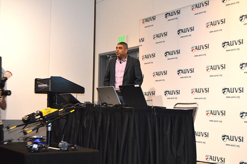
Intel’s Anil Naduri discussed some of the company’s updates at Xponential 2018. Photos by Allison Barwacz
Intel shared a number of updates at a presentation during AUVSI’s Xponential 2018, which took place April 30-May 3 in Denver. Among the company’s latest developments are its Insight Platform, Mission Control and Falcon 8+.
Intel Insight Platform
Intel’s Insight Platform is a digital asset management system that enables aerial data management and analysis. It allows customers to store, share and manage data that commercial drone systems collect. According to the company, the platform is designed to reduce costs, improve efficiency and fuel growth.
The Intel Insight platform takes the aerial data and can generate 2D and 3D models, take measurements and run data analytics.
“The asset-based approach allows you to tag repeated flights over the same location, and that provides a great foundation for you,” said Anil Nanduri, vice president and general manager of the Intel drone team.
Intel Mission Control
Intel’s Mission Control is the company’s next-generation flight planning software for its Falcon 8+ drone. According to the company, it is designed to increase workflow efficiency and enhance automation of drone flights for commercial missions.
Mission Control allows Falcon 8+ drone operators to create 2D and 3D flight plans for commercial surveying, mapping and inspection missions.
Intel Mission Control software is currently in beta testing with customers, Intel said.
Falcon 8+ drone
Intel revealed three new payloads for its Falcon 8+ at Xponential. Photo by Ryan Gerard
During the presentation, Intel revealed three new payloads, as well as distance hold and distance guard features, for its Falcon 8+ drone.
The three new payloads are designed for inspection, surveying and mapping applications. According to Intel, the Falcon 8+ also now boasts distance hold and distance guard features on the Intel Imaging and Duel Imaging payloads. The distance hold feature allows the drone to maintain and hold a set distance from certain obstacles during inspections, and distance guard is another obstacle avoidance feature.
The company also shared how the drone has assisted with natural disasters and safety inspections. The Falcon 8+ played a role in disaster relief for the Sonoma County fires, as well as data recovery following Hurricane Harvey in Houston.
The drone also assisted with a gas terminal inspection in Scotland, as well as with Arctic wildlife research.
“Drones are going to be the most transformative business technology in the coming generation,” Nanduri said.
Intelligent vehicles and smart devices could gain more accurate location awareness by fusing GNSS and Wi-Fi signals. A test for this is the focus of an Innovate UK project led by Spirent Communications and involving the Warwick Manufacturing Group (WMG) at the University of Warwick.
The £694k Enhanced Assured Location Simulator Leveraging Wi-Fi and GNSS Sensor Fusion (ELWAG) project will seek to develop and test the pioneering hybrid Wi-Fi and GNSS location system in a cost-effective, repeatable and safe environment so that manufacturers can verify its performance.
International Manufacturing Centre at WMG. (Photo: WMG)
Researchers at WMG, led by Matthew Higgins, will play a significant role in the project. They will take physical layer measurements of both Wi-Fi and GNSS signals in autonomous vehicle scenarios in and around the University of Warwick campus and the local urban road network.
The measurements will then assist in Spirent’s development of an RF propagation model that will overlay RF effects on its Wi-Fi Access Point simulator.
WMG researchers will then perform RF validation and verification activities around the developed model, to provide a level of assurance on its performance.
“The safety and functional assurance of future autonomous vehicles will be one of the many critical paths to large consumer adoption,” said Higgins, who is an associate professor in the intelligent vehicles group at WMG. “Through this project, we will contribute towards providing innovative solutions to the challenges of using sensor fusion in this testing context.”
“This is a highly technical project, which will require a holistic understanding of the signal propagation characteristics between satellites, infrastructure and vehicles. The results will impact future autonomous testing methodologies,” said Erik Kampert, senior research fellow at WMG.
The ELWAG project will run for 18 months, and also involves Chronos Technology.
Project background. Many devices currently rely on a singular location technology (typically GPS), which is one type of the wider eco system of GNSS. These systems, whilst becoming more capable, still suffer at times from the user’s environment — typically in urban areas where buildings and other cityscape features interfere with the signal.
The urban environment is, however, where most users need to know their location to the highest level of accuracy, due to increasing population or device density. Wi-Fi signals exist almost universally within dense urban areas, so there is a possibility of fusing these signals with the GNSS signals to identify one’s location very accurately.
“Currently Wi-Fi access point plus GNSS simulation can only be achieved in an ad hoc manner and does not allow for the testing of moving vehicles, multipath effects, insertion of data errors, spoofing and above all controlled, repeatable testing,” said Mark Holbrow, director of engineering and product development at Spirent’s positioning business unit.
“In the autonomous vehicle sector location accuracy can vary by up to 5 meters, which is unacceptable from a safety perspective. Bringing that accuracy down to 30 centimeters through sensor fusion will have substantial implications for autonomous navigation.”
Self-aware smart devices. The need for smart devices to have a highly accurate self-awareness of their own location, and the location of other smart devices around is becoming increasingly important.
In applications such as autonomous vehicles and transport systems, accurate location awareness is an obvious operational requirement for their safe operation in and around other vehicles, pedestrians or infrastructure.
In the personal devices space, smartwatches, phones and health monitoring and exercise aids are all striving to be able to make a judgment of the user’s state based upon location.
In the emergency and security services space, knowing the location of people and objects is also increasingly important as to target response capabilities effectively.
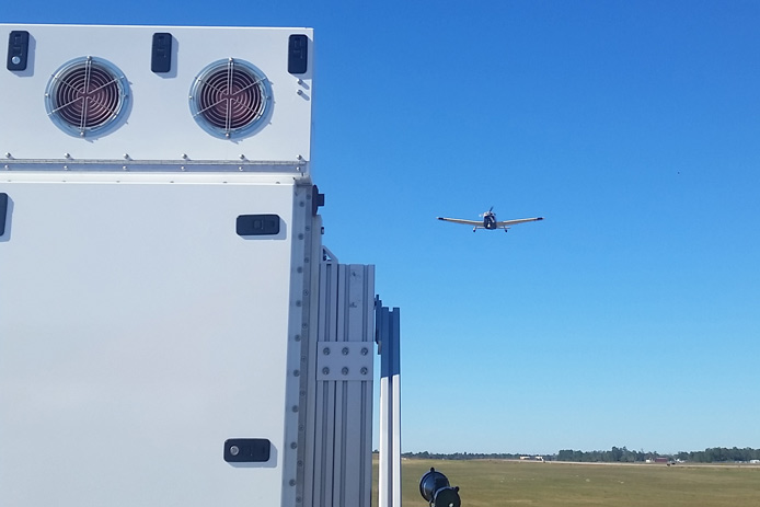
Raytheon’s Intelligence, Information and Services business will help plan, design, build and support the state’s next-generation air traffic management system to safely test and manage drones.
“UASs are playing an increasingly important role in our society, which means we must have low-altitude air traffic management solutions,” said Matt Gilligan, vice president of Raytheon’s Navigation, Weather and Services mission area. “The New York airspace corridor is the first-of-its kind, but it won’t be the last.”
A single-engine plane lands with the aid of a compact, Raytheon-made low-power radar during a flight-check demonstration for the U.S. government. (Photo: Raytheon)
The new corridor will extend 50 miles (80 kilometers) west from Griffiss International Airport, which is one of only seven Federal Aviation Administration (FAA)-approved unmanned aircraft systems test sites in America.
The corridor will allow companies to test both drones and air traffic management technologies in real-world settings, generating valuable data that will inform industry and regulators and ultimately advance the commercial use of drones.
“We have identified the most qualified organizations to complete the New York UTM corridor and expand our UAS testing capabilities,” said Maj. Gen. Marke F. “Hoot” Gibson (ret), NUAIR Alliance’s chief executive officer. “With all our state economic and technical support, I think we are well positioned to accelerate the UAS industry and further establish this region as a national leader.”
Raytheon’s leadership in air traffic management includes the low-power radar (LPR), a small, one-meter square Active Electronically Scanned Array (AESA) software-defined radar unit. When numerous LPRs are networked together, the radar units can cover and control the low-altitude flights of smaller craft — a feat not possible with current large radar systems.
A distributed, low-level LPR network could be created with relative ease, mounting the system atop current cell-phone towers or tall buildings.
A LPR network could support:
safe plane and drone landings
aviation surveillance
precision weather observations (including 3D wind information and urban hydrology)
Five organizations that flew drones on critical, life-saving missions are winners of the inaugural XCELLENCE Humanitarian Award by the Association for Unmanned Vehicles Systems International (AUVSI).
“We are thrilled to recognize and reward organizations who have utilized drone technology to make great contributions to their communities and the environment, through AUVSI’s inaugural Humanitarian Awards,” said Michael Perry, managing director of North America at DJI.
“We congratulate the winners and thank all those who have participated for sharing the innovative ways they use drones to support humanitarian and life-saving efforts around the world,” Perry said. “We hope this award will inspire more organizations and drone operators to accomplish great feats and help others in their community.”
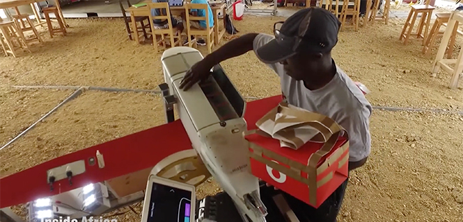
In Rwanda, fresh blood is launched to a hospital using a Zipline drone. (Image: CNN video)
These first recipients of the AUVSI XCELLENCE Humanitarian Award were recognized for using drones for disaster management, medical assistance and search-and-rescue operations at locations around the world:
Aeryon Labs Inc.: Aeryon SkyRanger UAS provides critical aerial intelligence to first responders in Sint Maarten in the wake of Hurricane Irma (Canada).
DroneSAR, DroneSAR UAV Search & Rescue (SAR) Solution: Executing autonomous aerial search and delivering live drone data to augment first response efforts (Ireland).
Nepal Flying Labs: drone hazard and vulnerability mapping in Nepal (Nepal).
ONG DroneSAR Chile: Emergency response team and humanitarian aid through the use of drones (Chile).
Zipline International: Zipline’s medical drone delivery operation in Rwanda (Rwanda).
“As these organizations have shown, unmanned aircraft systems that are typically flown for commercial purposes are also capable of accomplishing vital humanitarian missions,” said Brian Wynne, president and CEO of AUVSI. “With sophisticated on-board cameras and sensors, drones can quickly fly to remote locations or areas that are inaccessible to ground vehicles because of roads blocked by storm debris or flooding.”
The five organizations will equally divide a $25,000 donation as prizes for their ground-breaking humanitarian and philanthropic efforts.
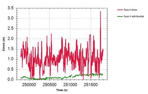
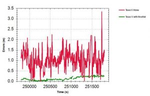
NovAtel has demonstrated high-accuracy positioning performance using automotive-grade GNSS chipsets Teseo APP and Teseo V from STMicroelectronics. Combining automotive-grade multi-frequency GNSS chipsets with positioning algorithms and correction services from NovAtel improves the achievable positioning accuracy available to automotive users and provides a solution suitable for autonomous operation.
According to the company, these chipsets provide multi-frequency GNSS data for precise point positioning (PPP) and real-time kinematic (RTK) to enable accurate positioning capabilities. Teseo APP features built-in integrity checking for use in safety-critical systems, whereas Teseo V is used for non-safety-critical precise positioning applications.
The collaboration between the two companies is designed to reach car manufacturers and Tier 1 suppliers for future production models.
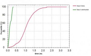
Test results: Horizontal position errors. Teseo V alone is shown in red, Teseo V + NovAtel in green. Test results: Horizontal cumulative error distribution. Teseo V alone is shown in red, Teseo V + NovAtel in green. (Chart: NovAtel)
Test results: Horizontal cumulative error distribution. Teseo V alone is shown in red, Teseo V + NovAtel in green. (Chart: NovAtel)
Driven Today. “STMicro is one of many chipset manufacturers coming to market with dual-frequency chipsets targeting the automotive sector,” said Jonathan Auld, VP Engineering and Safety Critical Systems for NovAtel. “We are taking advantage of their expertise in automotive measurement engines for high-volume, cost-effective reliable positioning. NovAtel brings high-precision algorithm expertise and integration with global corrections supplied by Hexagon Correction Services to this initiative.”
NovAtel’s positioning engine combines the GNSS measurements from these chipsets with inertial measurement unit (IMU) data and Hexagon Correction Services to deliver centimeter-level PPP positioning solutions in real time.
“Working closely with STMicroelectronics allowed us to innovate and drastically reduce time to market of our assured positioning solution tailored specifically for safe positioning of autonomous vehicles,” added Auld.
Comparison of GNSS Performance possible in automotive today (red), L1 automotive with corrections (green) and L1/L2 automotive with corrections (blue).
Driverless Tomorrow. “Precise absolute positioning is just one piece of the overall autonomous vehicle puzzle and must be done with safety and integrity concepts in mind.” Auld pointed to the partnership announced in 2016 between NovAtel, the Illinois Institute of Technology, and Stanford University to conduct leading-edge research to determine how GNSS technology can deliver a positioning solution that meets both the safety and accuracy requirements of autonomous automotive vehicles.
Previous research by academia and industry into GNSS integrity produced the successful WAAS program for aviation. The new work underway will extend the scope to include the autonomous ground vehicle use case. The research includes updated and expanded concepts for high-integrity carrier-phase algorithms as well as expanded threat models and safety monitors.
At the Automotive Tech.AD in Berlin, Auld added: “Today the primary use case for positioning in navigation is single-frequency GNSS, with up to 2 constellations, using narrowband RF and antennas, obtaining accuracy at the 1–2 meter level. This is primarily done with pseudorange-based positioning techniques, with some carrier-phase assistance. There are no functional safety standards, and so safety data is provided on the output solution.”
Autonomous Requirements. By contrast, he continued, autonomous operation will require lane-level and better accuracy: 3D centimeter to decimeter absolute positioning. This means multi-frequency, multi-constellation receivers and antennas to improve overall accuracy and increase available measurements. It will also require increased availability through sensor fusion with IMUs and other sensors. All of this must be brought together through a functionally safe development process targeted at ISO26262 Automotive Safety Integrity Level (ASIL) B.
Moving from meter to centimeter level position requires additional processing to handle all the added signals coming in; residual monitoring and observation exclusion, and carrier phase, “the key to centimeter-level positioning,” as opposed to code phase. The vehicle’s localization system must include enhanced positioning algorithms for multipath mitigation, a fast converging corrections network, enhanced Kalman Filters, and sophisticated sensor fusion.
Flexible Integration. NovAtel’s positioning engine architecture enables a flexible integration with different GNSS receiver chipsets, augmentation sensors and processor environments, providing automotive manufacturers with additional flexibility when it comes to sourcing of components and subsystems of advanced driver assistance systems (ADAS) and autonomous driving solutions.
The positioning engine is being developed to ASIL-B standards and will include a proprietary GNSS integrity solution to ensure safe positioning within defined protection limits tailored to the customer’s application requirements.
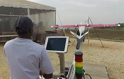
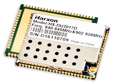
Harxon showcased high-precision positioning GNSS antennas and its latest wireless data-transmission technologies for UAV applications at AUVSI Xponential, which was held April 30-May 4 in Denver.
The Harxon D-Helix Antenna.
Harxon’s D-Helix is a patented D-QHA (dual-quadrifilar helix antenna) multi-constellation antenna supports excellent reception of GPS, Galileo, BeiDou and GLONASS, as well as L-band signals. Harxon D-QHA technology ensures the ability of low elevation satellites tracking while maintaining 4-dBi high gain, which makes the D-Helix antenna an excellent choice for any applications where the sky is partially visible, the company said.
The antenna’s low noise amplifier (LNA) with out-of-band rejection performance can suppress electromagnetic interference. Moreover, the D-Helix features the latest low wind resistance design with ruggedized IP67 protection for UAV inspection and monitoring, survey and mapping or agricultural UAVs.
Photo: Harxon
The HX-DU2017D is a 5-gram frequency-hopping OEM transceiver supporting frequencies between 840 MHz and 900 MHz. It provides strong anti-jamming and signal receiving capability for complex data intensive applications. Its full duplex mode ensures data secure transmission, more stable long-range communication and short latency of data transmission.
Watch this video to learn more about the HX-DU2017D.
Other showcased Harxon GNSS products, such as Helix Antenna HX-CH7603A, HX-CH4601A and HX-CH6601A, are all featured with patented D-QHA technology. Moreover, the showcased Survey Antenna GPS 500, OEM Modem HX-DU1018D and Smart Antenna are also appropriate for surveying and mapping, as well as precision agriculture.
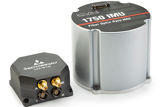
The products are on display in KVH’s (#2600) and VectorNav’s (#2214) booths at the AUVSI Xponential conference in Denver, Colorado, taking place April 30-May 3.
The VectorNav Tactical Series products with KVH’s FOG-based inertial measurement units (IMUs) combine the precision and reliability of KVH’s FOG technology with the robust filters and high-performance navigation algorithms of VectorNav’s inertial navigation systems.
The combined capabilities represent an affordable, effective alternative to larger, higher-cost inertial navigation systems and provide improved accuracy in challenging environments, the companies said.
Photo: VectorNav/KVH
VectorNav’s Tactical Series includes an onboard micro-electromechanical systems (MEMS)-based IMU, which provides some advantages for customers who have constraints in terms of size and weight in their navigation and stabilization applications.
However, in terms of inertial accuracy, the most demanding applications require performance that can only be delivered by FOG-based IMUs, for which KVH is a leading provider.
The VectorNav Tactical Series products with KVH FOG-based IMUs are designed for such applications as:
Satcom On The Move
gimbal and camera pointing and stabilization
weapons systems targeting and stabilization
autonomous vehicle navigation
lidar mapping
georeferencing
or any application where MEMS-based solutions are unable to deliver sufficient accuracy and precision.
Watch this video from Xponential 2018 to learn more about the partnership.
A single cable connects the two systems, running from KVH’s 1750 IMU or 1775 IMU directly to the auxiliary port on the VN-210 or VN-310. This pairing creates a fully integrated FOG-based inertial navigation system designed to provide a high-accuracy, continuous positioning, velocity, and attitude solution.
KVH is a leading innovator for assured navigation and autonomous accuracy using high-performance sensors and integrated inertial systems. KVH’s widely fielded TACNAV systems are in use by the U.S. Army and Marine Corps as well as many allied militaries around the world.
KVH’s FOGs and FOG-based IMUs are in use today in a wide variety of applications ranging from optical, antenna, and sensor stabilization systems to mobile mapping solutions and autonomous platforms and cars.
“We are pleased to feature KVH technology in our Tactical Series and give our customers the option of utilizing a FOG-based IMU for higher precision performance to support a wide range of demanding applications,” said Jakub Maslikowski, director of sales and marketing for VectorNav.
“The combination of VectorNav’s Tactical Series products with our FOG-based IMUs provides a great solution for applications that require advanced inertial navigation capability and FOG-level IMU performance,” said Jay Napoli, vice president of FOG/OEM sales for KVH.
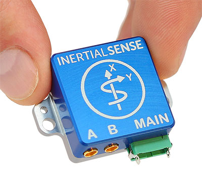
Inertial Sense has announced the availability of a micro-sized rugged version of its combined GNSS-INS module, which has an onboard GNSS receiver as well as a fully fused inertial navigation solution.
Designed to fill autonomous vehicle and sensing needs, the module is also available in AHRS/IMU versions.
At 10 grams and with 1 x 1-inch footprint, the solution provides accuracy of 0.1-degree roll/pitch and 0.3-degree dynamic heading. It is also ITAR-free module.
The modules represent 15 years of inertial navigation and motion measurement experience, according to the company.
“When I set out on this journey to provide an accurate and low-cost navigation solution, I wanted to produce a product that engineers could purchase off the shelf, hassle free,” said company founder Walt Johnson. “In my past as a UAV engineer, I was always looking for ways to save myself time and money. It’s all about convenience. There is no need to spend time choosing IMU sensors and writing the algorithms to fuse navigation data. We provide it all for you.”
 By coordinating their product offerings, they seek to meet growing demand for increased positioning accuracy for mass-market applications. Some of the areas driving up demand for high-precision positioning services in China are internet of things (IoT) tracking devices such as those used on shared bikes, as well as automotive, UAV and robotic vehicle applications.