The airport’s new autonomous ATV begins testing in August. (Photo: Edmonton International Airport)
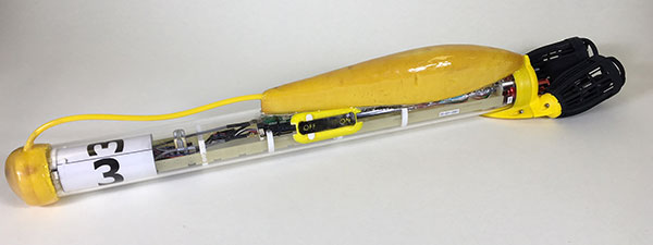
An autonomous all-terrain vehicle (ATV) equipped with NovAtel Inc. technology will soon join the security fleet at the Edmonton International Airport in Alberta, Canada.
The ATV will be used to detect people and animals that breach the airport perimeter, as well as locate holes in the fence to alert the security team.
This is the only known autonomous ATV to be used for airport security and it will be used to monitor its 20-kilometer fence line on a narrow perimeter road, according to Hexagon, NovAtel’s parent company.
The unarmed vehicle is controlled remotely by humans and can also drive autonomously, incorporating machine-learning to perform its tasks.
The vehicle system includes navigation, path planning, obstacle avoidance, animal and human recognition, communication systems to airport security, geo-fencing, and situational awareness and analysis.
The autonomous ATV patrols will focus on the following:
Identifying damage to the chain-link fence and fence posts, verifying barbed wire is taut and undamaged, and detecting holes or gaps under the fence
Detecting human or animal activity
Searching for obstacles using lidar
“We would not have been able to navigate the vehicle on such a narrow road if we had not used NovAtel gear,” said Ken Brizel, CEO, ACAMP.
The autonomous security ATV was developed by the Alberta Centre for Advanced MNT (microprocessor and nanotechnology) Products (ACAMP).
The airport is a member of the Advanced Systems for Transportation Consortium established by ACAMP and supported by the Government of Alberta. ACAMP is a member of the Alberta Aerospace and Technology Centre at EIA. ACAMP and EIA were able to harness technologies developed by consortium members to construct and test the autonomous ATV security vehicle, readying it for regular use at EIA.
NDCOE’s mission is to save lives and reduce air hazards from drone incursions by empowering a shared safety vision with the the U.S. Federal Aviation Administration’s (FAA’s) integration of drones into the commercial air traffic system.
Located in Las Vegas, with facilities donated by technology infrastructure company Switch, NDCOE will provide safety incursion research data, drone technology best practices and educational materials.
The new center will conduct public workshops that promote and protect the public’s safety and privacy in an open and ethical manner.
Over the last decade, UAS, more commonly referred to as drones, have experienced an unprecedented boom within aviation. Coinciding with the increase in popularity, incidents involving drones in tourist areas, as well as risks to larger manned aircraft are on the rise and present high-liability risks to property owners.
Safe and successful UAS operations rely on quality training, end user education and maximizing public safety processes. To protect and educate residents and visitors, the center seeks to protect against drone users who pose a public safety hazard due to inexperience or malicious drone operations. Such hazards include drones hitting people or that have the potential to cause an airline disaster, and drone operations that violate safety, privacy or drone laws near high-traffic public places, at airports, near military bases or near critical infrastructure.
NDCOE will also advance drone surveillance, detect and avoid (remote sensing), wildland firefighting, gas-leak detection, and time-sensitive medical delivery technologies for life-saving medical equipment and organs.
“In addition to fostering major advances in UAS technology with testing partners like the FAA, NASA and Switch, Nevada is also home to the most registered drone users in the nation in Las Vegas,” said Paul Anderson, executive director of the Nevada Governor’s Office of Economic Development. “This dynamic makes such a program as the Nevada Drone Center of Excellence for Public Safety a natural step as drones increasingly become a bigger part of our daily lives.”
In a recent state-wide Nevada Drone Industry survey by the University of Nevada, Las Vegas (UNLV) and NIAS, the NDCOE received support to open the first center of its kind in the U.S. In the survey, almost 80% of respondents were concerned about a recreational drone hitting an airline and causing an airline disaster, and almost 90% were concerned about aerial drones illegally penetrating FAA airspace without authorization at outdoor events such as sports stadium, concert or at large events.
“We are taking an aggressive approach toward solving the complex UAS Industry challenge of mitigating drone incursions into the National Airspace System — one of the toughest FAA challenges today,” said Chris Walach, senior director, NIAS and the FAA-designated Nevada UAS Test Site. “What we are doing in Nevada will be of immense value to the DOT, FAA, DHS, DOJ, commercial airlines, visitor venues, and the UAS Industry. This new center will help advance infrastructure protections, drone detection innovations, enhance air safety, and expand air commerce in Nevada.”
NIAS and the FAA-designated Nevada Unmanned Aviation Test Site lead the growth of the Nevada UAS industry through business teaming relationships, collaborating with primary research institutions on UAS research and development, and enhancing the Nevada UAS Industry knowledge base to attract new and permanent business and create jobs in the State of Nevada.
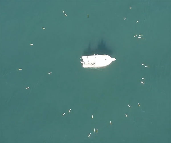
SwarmDivers by Aquabotix are micro swarming unmanned surface vehicles (USVs) capable of diving to 50 meters and swarming in groups of 40 or more.
Multiple SwarmDivers can function simultaneously as a single coordinated entity, be easily controlled via one operator on the surface and perform dives on command to collect valuable intelligence.
Their design delivers rugged reliability and accuracy for applications requiring specialized sensor payloads in defense, oceanography, aquaculture, research and hydrographic survey, the company said. The units also operate collectively to quickly gather data and report back in near real time.
This screenshot from an Aquabotix video shows the swarm returning to base. (Image: Aquabotix)
The swarming algorithm allows vehicles to communicate with each other to make decisions as a group. This allows SwarmDiver to quickly and accurately self-arrange in various swarm formations as well as dive simultaneously to collect synoptic data sets.
With the ability to be outfitted with customized payloads and sensors, SwarmDiver can meet a wide range of mission profiles, Aquabotix said.
For the defense community, SwarmDiver could provide surf-break-zone operations support, enhanced navigational capabilities, explosive ordnance disposal and mine countermeasures.
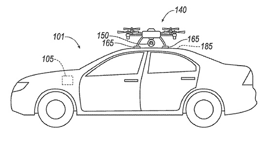
Ford has applied for a patent that would send a drone to dock with an autonomous vehicle and act as a surrogate sensor if one of the car’s sensors failed. The UAV then uses its own sensors to guide the car to a repair facility.
A UAV docks with a car. (Diagram: Ford’s patent application)
The filing from Ford Global Technologies, a subsidiary that manages and commercializes patents and copyrights, outlines the process.
Once the vehicle registers a fault in one of its sensors, it uses a vehicle-to-vehicle (V2V) network to summon the drone, which flies to the vehicle, receives authorization, and then lands atop it. The UAV then serves as a replacement sensor while directing the vehicle to a nearby repair center to fix the car’s sensor.
Ford developed the technology to aid autonomous vehicles that have lost a critical navigation sensor; autonomous cars use GNSS, short- and long-range radar, lidar, cameras and ultrasound.
GNSS antenna maker Tallysman has introduced the TW7875 magnetic mount GNSS antenna, which is designed for precision dual-frequency positioning. It is capable of receiving GPS L1/L5, GLONASS G1, BeiDou B1, Galileo E1/E5a and NavIC L5.
The TW7875 employs Tallysman’s Accutenna technology, which provides superior multipath signal rejection due to its low axial ratio across the full bandwidth, the company said.
The antenna also provides a linear phase response and tight phase center variation at a new economical price point, according to the company, which said it provides performance comparable to higher priced dual-band GNSS antenna.
It is designed for precision agriculture, autonomous vehicles and other applications where precision matters.
The TW7875 is housed in a magnetic mount IP67 rated housing. It can also be ordered without the magnet since it can also be mounted by screws or double-sided adhesive tape.
Model TW3875 is the embedded antenna version of the TW7875. It is available with a wide selection of connectors and custom cable lengths, and can be custom tuned by Tallysman to ensure optimum performance within the customer’s enclosure.
Streamlined application and 30-minute response improve unlocking process.
DJI’s Matrice 200 drone. (Photo: DJI)
Drone maker DJI is introducing improvements to its geofencing system. Professional drone pilots with authorization to fly in sensitive locations can now use a streamlined application process to receive unlocking codes within 30 minutes.
DJI’s geofencing system uses GPS and other navigational satellite signals to automatically help prevent drones from flying near sensitive locations such as airports, nuclear power plants and prisons. These improvements are carefully designed to help expand the beneficial uses of drones in sensitive areas that have been restricted in DJI’s geofencing system.
While those areas will remain restricted to more casual drone pilots, DJI now staffs its global authorization team around the clock in order to process applications and provide unlocking codes quickly.
Professional drone pilots can apply to unlock restricted zones at www.dji.com/flysafe/custom-unlock. This portal page allows pilots to easily enter information about their aircraft and controller, as well as authorization documents supplied by the controlling authorities in areas where they wish to fly.
Enterprise users can for the first time include multiple aircraft in a single unlocking request.
“DJI now processes most requests within 30 minutes, though requests involving unusual circumstances or requiring additional documentation may need additional time,” said Michael Perry, managing director of North America at DJI. “By making it easier for authorized pilots to put drones to work in sensitive areas, DJI is once again showing why professional drone operators choose our aerial platforms for the most important tasks.”
“DJI first implemented geofencing in 2013, and it is now established as an important tool to help our customers make thoughtful flight decisions, while also addressing legitimate concerns about safety and security by helping prevent unauthorized flights in the most sensitive locations,” said Brendan Schulman, vice president of policy & legal affairs at DJI. “These improvements illustrate DJI’s ongoing commitment as the industry leader to continually improving the safety features we implemented years ago, while enabling beneficial applications for our technology.”
For more information about how enterprises are using DJI products to work safer, faster and more efficiently, visit enterprise.dji.com.
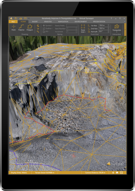
The newly released version 6 of the Virtual Surveyor drone surveying software offers a faster, more efficient workflow and better overall user experience in a more stable platform, according to the software maker.
Version 6 offers new capabilities, an improved licensing system and an extended free application.
“Surveyors who have used the Virtual Surveyor package in the past will be amazed at how easily they can manipulate data and how quickly the software renders results of even the most complex topographies,” said Tom Op ‘t Eyndt, managing director of Virtual Surveyor nv in Belgium.
Virtual Surveyor leverages the expertise and interpretation skill of a land surveyor and combines it with the computing power of the computer, the company said.The software generates an interactive onscreen environment through orthophotos and digital surface models, generated from the unmanned aerial vehicle (UAV), where the surveyor selects survey points and breaklines to define the topography.
Image: Virtual Surveyor
Virtual Surveyor enables land surveyors to complement traditional fieldwork with UAV imagery to generate highly accurate topographic products up to five times faster than otherwise possible. It bridges the gap between UAV photogrammetric processing software and engineering computer-aided design (CAD) packages.
“The focus of Version 6 development has been to streamline the workflow — from the importing of drone data to exporting topo information into CAD — to make the surveyor more productive,” Op ‘t Eyndt said.
Key enhancements in Virtual Surveyor 6 include the following:
Easier editing – The new editing functions allows users to quickly select, delete or move individual point and lines placed by the computer during the automated creation of elevation points. The associated Undo/Redo function allows reversing all edit operations.
Better CAD integration – The addition of Descriptor functionality means that point descriptions remain with the point during export to CAD, working the same way as the land surveyor collects data in the field.
3D geometry retained – All points, lines and other data imported into the software, either from a UAV or field surveyed data, retain elevation values and integrate seamlessly into the merged scene. This allows a surveyor, for example, to collect point values from a ditch bottom that may be obscured by vegetation in the drone image and have the bottom points accurately represented in the topography.
Improved drawing tools – Users can now densify (drape) lines and boundaries to map current surface conditions. Individual vertices are now adjustable in all directions and exact X, Y and Z locations can be specified as well. Sub-surface modeling is now possible with these new improvements. Created features can then be exported to CAD for profile or alignment creation.
Extended free plan – Referred to as the Valley version, the free Virtual Surveyor suite has added functionality, including the ability to import photogrammetric data.
Improved licensing – We better honor our principle: “The license follows the user”. With an improved licensing system based on a Virtual Surveyor Identity (email) the user will be able to work where he or she wants.
“The enhanced user experience will continue to appeal to professional land surveyors, who are our core client base,” said Op ‘t Eyndt. “And the seamless integration with CAD and advanced drawing tools will make Virtual Surveyor more attractive to design engineers.”
Virtual Surveyor is available in a free 14-day trial.
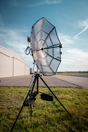
Designed to incorporate aircraft into the MANET, the Auto-Tracking Antenna System is a complete portable ground-to-air system for tracking aircraft, including drones. Army, Navy and foreign customers can use it for better airborne communications relay and full-motion video camera/sensor data transmission, Persistent said.
Photo: Persistent Systems
“The Auto-Tracking Antenna System represents a major step towards achieving the vision of a truly networked battlefield,” said Herb Rubens, CEO of Persistent Systems. “The tracking antenna rotates to follow air assets, keeping them connected to the MANET. “The air platforms orbit over our users on the ground, extending the MANET bubble and keeping soldiers connected to the enterprise. High throughput, low latency connectivity empowers the warfighter and decreases the dependence on SATCOM, which both reduces cost and increases network availability.”
Designed for ease-of-use, quick assembly and portability, the Auto-Tracking Antenna System can be assembled and deployed in less than 15 minutes, the company added.
The portable and lightweight design is completely collapsible, with the main five-foot parabolic dish breaking down into eight individual petals.
The entire system fits into most standard-sized SUVs for easy transport and compact storage.
Photo: Persistent Systems
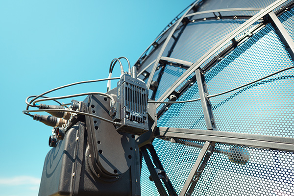
Mimicking the MPU5’s modular RF structure, the Auto-Tracking Antenna System has interchangeable S-band, L-band and C-band MIMO feeds that allow it to cover all frequencies where Persistent’s five radio modules operate.
The antenna feeds twist-lock into place for quick and simple installation. An Automatic Heading System enables the tracking antenna to self-calibrate prior to operation for greater precision and less than one-degree pointing accuracy.
“Our customers require a system that is simple to put together, turn on, and works,” said Louis Sutherland, vice president of business development at Persistent Systems. “They want to extend the Wave Relay MANET out to aircraft and achieve high data-rates and reliable HD video transmission. The Auto-Tracking Antenna System truly delivers.”
The large parabolic dish enables video streaming out to distances of 130 miles (over 200 kilometers) while maintaining high throughput and strong signal strength.
Photo: Persistent Systems
Combining the precisely aimed tracking system with the MPU5 radio and Wave Relay MANET achieves optimal connectivity and reliable communications for manned and unmanned aircraft to communicate further than ever before.
The antenna is IP67 rated and built to endure harsh environments and weather, so it can be setup and left out for as long as the mission requires.
A news story from Australia’s “Today Tonight Adelaide” television show highlights how the DroneShield system can bring down drones that enter restricted airspace or threaten safety. DroneShield countermeasures allow for the controlled management of drone payloads such as explosives, with no damage to common drone models or the surrounding environment.
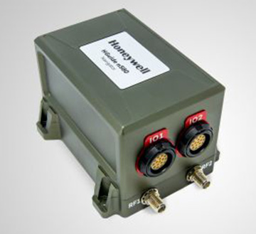
Honeywell has produced a new inertial navigation unit that provides accurate navigation for customers across a broad range of industries including agriculture, robotics and autonomous vehicles, without compromising on size, cost or performance.
The HGuideN580 inertial navigation technology improves accuracy in urban and rural environments. (Photo: Honeywell)
The HGuide n580 is the first Honeywell-produced, industrial-focused navigation solution that uses both precision inertial measurement unit technology and GNSS to improve location accuracy even when facing natural and manmade obstacles.
“The blend of inertial and satellite navigation capabilities provided by the HGuide n580 is especially important where precision is required in demanding environments — for example, autonomous cars traveling in cities, where our technology can extend the accuracy and performance of navigational systems while keeping passengers safe,” said Chris Lund, senior director, Navigation and Sensors, Honeywell Aerospace. “Honeywell’s history and expertise in navigation technology enables customers to implement this new wave of advanced technology into their own applications and operations.”
Roughly the size of a deck of cards, the HGuide n580 gives Honeywell’s industrial customers the capabilities needed to navigate accurately in areas with limited satellite coverage, such as densely populated cities where tall buildings, underground tunnels, and multi-layer freeway stacks or bridges often create challenges to traditional GPS navigation.
For a GPS unit to function properly, it requires a strong signal connection between the unit on the ground and multiple satellites in the sky to accurately orient its position. City infrastructure such as buildings and tunnels can temporarily block the signal between GPS unit receivers and satellites, creating urban canyons.
With the HGuide n580 integrated system, Honeywell’s inertial measurement unit technology combines with GPS to act as a backup solution, which means the loss of GPS signal caused by an urban canyon does not result in a complete loss of navigation.
To learn more about the new HGuide n580 solution and Honeywell’s other commercially available navigation technologies, visit the Honeywell Aerospace website.
The Association for Unmanned Vehicle Systems International (AUVSI) has formed an Unmanned Maritime Systems (UMS) Advocacy Committee to focus on the development of policy positions to support the advancement of the industry.
“Unmanned maritime systems allow military and commercial operators alike to go farther and deeper than ever before,” said Brian Wynne, president and CEO of AUVSI. “The input provided by the UMS Advocacy Committee will help us speak with a unified voice and enable all our members to advocate for the growth of the industry.”
The UMS Advocacy Committee will be chaired by Thomas Reynolds, vice president of business development for Hydroid Inc./Kongsberg Maritime. Reynolds, who leads all Kongsberg Maritime business with the U.S. government, previously served as a commissioned officer in the U.S. Navy, where he served as commander of the Explosive Ordinance Disposal Task Group, U.S. Fifth Fleet, among other roles.
Reynolds holds a bachelor of science degree from the U.S. Naval Academy and an executive master of business administration from Benedictine College.
Wayne Prender, vice president for Applied Technology and Advance Programs at Textron Systems, will be the committee’s vice chair. In his role at Textron, Prender is responsible for engineering development programs, advancing areas such as the Common Unmanned Surface Vehicle and Cased-Telescoped Weapons and Ammunition, as well as emerging capabilities and development programs.
Prender is a former commissioned officer in the U.S. Army, where he was deployed to Iraq and awarded the Bronze Star. He holds a bachelor’s degree in mechanical engineering from St. Louis University, a master’s degree in technology management and a master of business administration from the University of Maryland University College.
The committee also includes representatives from BAE Systems, L3 Technologies, Leidos, Lockheed Martin, Northrop Grumman and Seaborn Defense.
The UMS Advocacy Committee formalized a set of policy priorities to help guide the committee’s legislative and regulatory actions. The priorities state that the committee shall:
Establish the UMS Advocacy Committee as the preeminent industry voice influencing acquisition and regulatory policies and processes.
Facilitate the growth of UMS through active engagement with the government and commercial sectors.
Collaborate with ship owners, operators, shipyards, ports, federal maritime agencies, technology developers, classification societies and academia to further integrate advanced automation for maritime platforms into the domestic market.
Develop the future of the UMS workforce through technology-focused education.
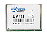
The UM442 can simultaneously track GPS, BDS, GLONASS and Galileo. It also supports SBAS and QZSS. It uses Uncore’s new-generation Nebulas II chip and UGypsophila real-time kinematic (RTK) algorithm. Based on high-performance data-sharing technology and the simplified operation system of the Nebulas II chip, the UGypsophila RTK algorithm dramatically optimizes matrix processing, enabling the UM442 to track more satellites and shorten the initialization time to 5 seconds.
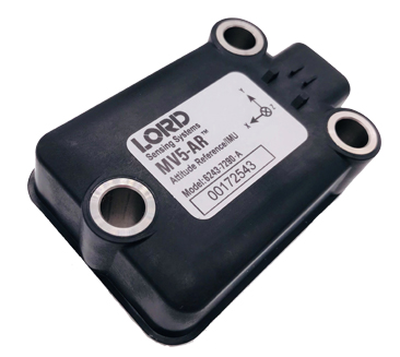
The MV5-AR inertial sensors are designed for off-highway and military vehicles, marine and mobile robot applications, and the autonomous vehicle market. The rugged, compact sensors use LORD’s fifth-generation high-performance industrial-grade solid-state six-degrees-of-freedom (6-DOF) micro-electromechanical accelerometer and gyro inertial sensor technology. Successfully deployed on ground robots and heavy machinery, applications also include autosteer and terrain compensation; dynamic incline detection (roll, pitch, rotation); vehicle stability and leveling; platform control, alignment and stabilization; operator feedback; and precision navigation. The compact and rugged reinforced housing is fully sealed for immersion and pressure wash. Each sensor is calibrated and temperature compensated.
BeiDou Phase 3 signals are now available on Spirent GNSS RF constellation simulators GSS7000 and GSS9000 — existing users can obtain the software upgrade by contacting Spirent. Phase 3 of the Chinese BeiDou system will extend its coverage from Asia to the entire world, providing receiver developers and integrators with additional GNSS signals to make positioning, navigation and timing systems more accurate, and help to support new applications, such as autonomous vehicles. Customers can test their designs before the system is fully operational in 2020.
The ZED-F9P multi-band GNSS module has integrated multi-band real-time kinematic (RTK) technology for machine control, ground robotic vehicles and high-precision unmanned aerial vehicles applications. It measures 22 x 17 x 2.4 millimeters and uses technology from the u‑blox F9 platform to deliver robust high-precision positioning performance in seconds. The ZED-F9P is a mass-market multi-band receiver that concurrently uses GNSS signals from all four GNSS constellations (GPS, GLONASS, Galileo and BeiDou). Combining GNSS signals from multiple frequency bands (L1/L2/L5) and RTK technology lets the ZED‑F9P achieve centimeter-level accuracy in seconds.
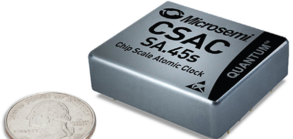
The SA.45s Commercial Space Chip-Scale Atomic Clock (CSAC) is a commercially available radiation-tolerant CSAC suitable for low Earth orbit (LEO) applications. The device provides the accuracy and stability of atomic clock technology while achieving significant breakthroughs in reduced size, weight and power consumption. It provides excellent drift performance and built-in 1 pulse per second (PPS) input for GPS disciplining, making the device well-suited for holdover applications. Commercial and research space applications include satellite timing and frequency control; satellite cross linking; assured position, navigation and timing; and Earth observation.
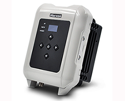
The long-range, power-efficient eRadio is designed to support high-precision GNSS real-time kinematic (RTK) applications in surveying and precision agriculture. It is enabled with intelligent serial baud rate identification for different RTK devices. It can automatically identify RTK serial baud rate with a radio data cable and provide a plug-and-play form for easy connection between the eRadio and RTK. With its high transmitting power (5-35 Watts), transmission data can be up to 19200 bps/s over a connection distance of 50–80 kilometers. It can work as either a base or repeater with other Harxon radio modems in challenging environments.
Wireless communication with any Android or Windows terminal
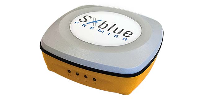
Image: SXblue/Geneq
The SXblue Premier GNSS receiver is available in a submetric version (GNSS) or centimetric version (RTK). It is equipped with Pacific Crest Maxwell 6 Trimble technology with BD910 (GNSS version) and BD930 (RTK version) OEM boards, delivering 220 channels to acquire and track GNSS signals from all constellations in view. It makes effective use of GPS, GLONASS, Galileo, BeiDou, QZSS and SBAS signals for precise positioning.
The single-frequency, multi-GNSS Vector V123 and V133 all-in-one smart antennas are multi-GNSS compass systems using GPS, GLONASS, BeiDou, Galileo and QZSS for simultaneous tracking for heading, position, heave, pitch and roll. Both support NMEA 0183 and NMEA 2000. The V123 and V133 thrive in radar/ARPA, AIS, ECDIS, side-scan survey, multi- and single-beam surveys, dredging and general navigation applications.
The Trak4 provides GPS tracking with cell-trilateration fallback. Ping rates can be selected from every two minutes to once a day, with email and text alerts provided for geozone entry and exit or if the high-capacity rechargable battery is low (the battery runs up to 12 months on a single charge.) The Trak4 is designed for tracking vehicles, assets and inventory; it can also be used to track people such as the elderly. Indoor/outdoor weatherproofing allows “anywhere” mounting.
PCTEL’s multi-GNSS L1/L2/L5 antennas combine aerospace-level precision with global satellite compatibility in a highly durable package. They enable critical applications including vehicular automation, 5G network timing synchronization and Positive Train Control (PTC) systems. The antennas increase the accuracy of timing and location information by providing simultaneous access to multiple GNSS signals across multiple frequency bands. The antennas support all relevant GPS, GLONASS, BeiDou and Galileo frequencies with excellent multipath mitigation and high out-of-band rejection for greater signal clarity. Their robust AAR and IP67-compliant design makes them suitable for years of use on railways and in other harsh real-world environments.
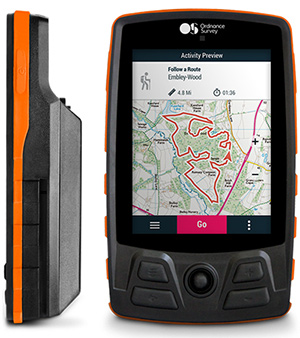
Four new GPS handhelds are designed for off-road use, with safety in mind. All four of the OS GPS models have a built-in SIM card with access to the SeeMe subscription-based service and its safety features. With I.C.E (In Case of Emergency), users can send emergency alerts with exact coordinates to family and friends directly from the OS GPS. Live Tracking enables the user to be locatable at all times, sharing location and performance data with up to 20 friends in real time. Aventura, the most advanced navigation device, can be used in all weather conditions.
Zubie Fleet Connect provides real-time GPS fleet tracking, driver check-in and performance reports, and vehicle health alerts. The monitoring and reporting service lets managers of fleets from 2 to 5,000 vehicles optimize business on the road. Wi-Fi connection to the cloud delivers important information about the health and performance of the vehicle, enhancing driver safety. Zubie also works with large enterprises to develop custom data flows and access driving data that can be used to analyze driving patterns, spot geographical trends in activity, or improve fleet asset management based on vehicle wear and tear.
The Heliscope 2.0 provides onboard data collection with speed, efficiency and productivity improvements for the utility inspection industry. It provides a solution for operations over greater distances or in harsher environments than drones can accommodate The system integrates multiple sensor systems into a single, lightweight helicopter payload, capable of simultaneously collecting a range of data types required for utility maintenance and vegetation management inspections. Deployment enables optimized inspection and maintenance schedules, offering potential cost savings in those operational activities by as much as 50 percent. The Heliscope 2.0 has flexible mounting configurations and the ability to adapt for mounting on many different helicopter types.
Based on DJI’s M600 Pro platform, the Leica Aibot system is designed to rapidly and autonomously enable digitizing of critical infrastructure. It enables users to get a complete data set quickly with a user-friendly interface. Using Leica Infinity for point-cloud, digital surface model and orthophoto generation enables surveyors to process and visualize aerial data. For construction projects, Aibot provides access to critical information to perform volume calculations and monitor site progress. Users can see high-definition imagery and 3D mapping of the site and document progress. The UAV data can be combined with other survey technologies such as GPS for a more complete set of information.
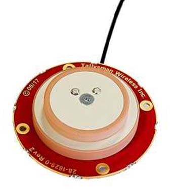
Two lightweight, compact antennas are designed for UAVs with a low aerodynamic profile. Antenna model TW1829 is for original equipment manufacturers (OEMs), and model TW8829 is a housed version. Accutenna technology provides high-level rejection of multipath signals, a phase linear response and tight phase-center variations. Pre-filters prevent saturation of the front-end low noise amplifier by strong near frequency and harmonic signals.
The HA32 high-performance antenna supports GPS, GLONASS, Galileo, BeiDou and Hemisphere’s Atlas L-band correction service. It is designed for UAVs, geographic information systems (GIS), surveying, real-time kinematic (RTK) and other applications requiring high-precision positioning and navigation. The HA32 is built on a proprietary four-helix antenna technology that provides superior filtering and anti-jamming performance with features such as a low noise figure of 2.0 dB (typical) and up to 30-dB gain (typical). Suitable for most outdoor and harsh operating environments, the HA32 antenna is sealed in a durable and ruggedized IP67-rated. The lightweight (40 g, typical), compact form factor (40 x 75 mm) makes it resistant to wind when on UAVs.