Upgrades to the monitoring stations underpinning Europe’s EGNOS satnav augmentation system will support its evolution, said the European Space Agency.
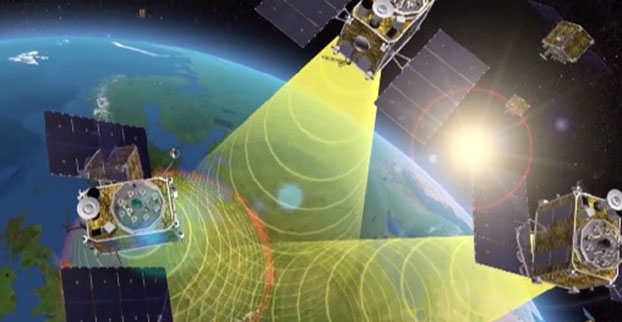
The current 40 Ranging and Integrity Monitoring Stations (RIMS) sites across Europe and beyond are the bedrock of the European Geostationary Navigation Overlay Service (EGNOS), supplying highly accurate and robust satnav information that can be relied on for safety-critical purposes.
Thales EGNOS V3 RIMS rack.
Once a second, these stations gather raw satnav data to transmit information on signal quality and range measurements to the GPS satellites, allowing EGNOS to identify and remove any error in the signals.
The resulting corrections are then passed to users via a trio of geostationary satellites, delivering a several-fold increase in precision plus “integrity” — a guarantee of navigation service — for safety-of-life applications.
The result is that the EGNOS-augmented signals are guaranteed to meet the extremely high performance standards set out by the International Civil Aviation Organisation standard, adapted for Europe by Eurocontrol, the European Organisation for the Safety of Air Navigation.
The signals from space can therefore be relied on routinely for safety-critical tasks, such as vertically guiding aircraft during landing approaches.
“These current RIMS V2 stations have some inherent limitations, which we’ve sought to tackle in this upgraded V3 design,” said Didier Flament, ESA’s EGNOS programme manager.
Airbus EGNOS V3 RIMS rack.
“For instance, our current stations work only with GPS frequencies L1/L2 P(Y), while the future post-2020 EGNOS system will be operating on a multi-constellation basis, additionally employing modernized GPS signals, notably on both the L2 (L2C) and L5 frequency bands, as well as other signals from Galileo, on the similar E1 and E5 frequency bands.
“Our experience working with RIMS has emphasized the significance on performance of factors such as signal scintillation — caused by the ever-changing ionosphere, the electrically active layer of the upper atmosphere — as well as other environmental threats such as interference and multipath signal reflection.
“So this upgraded design increased robustness to these factors, based on more stringent development and operating standards, along with innovative radio-frequency environment monitoring.
“It also includes upgraded receiver technology to accurately monitor potential GPS and Galileo signal distortion — ‘evil waveform’ signal anomalies — in full compliance with international standards.”
The RIMS V3 stations will be based in the same or similar secure location as today’s stations — typically airports or space-based telecommunication sites.
Dual tracking antenna concept incorporated in EGNOS V3 RIMS design.
The individual RIMS antennas themselves can be relatively compact, about 50 cm high, with links to receiver and computing equipment.
Most of the RIMS V2 station antennas are currently surrounded by dedicated protection structures that limit the impact of interference and multipath local effects.
Raytheon Company has launched its GEO 6 satellite payload into orbit for its 12-year mission. It is the latest payload to support the Federal Aviation Administration’s (FAA) Wide Area Augmentation System (WAAS), which enhances the reliability and accuracy of GPS signals for directing air travel.
The Raytheon-developed payload is a key element of WAAS, which offers commercial, business and general aviation pilots more direct flight paths, greater runway capability and precision approaches to airports and remote landing sites without dependence on local ground-based landing systems.
“This latest payload launch is the next step in our journey with the FAA to bolster navigation safety and efficiency for commercial and general aviation,” said Bob Delorge, vice president of transportation and support services for Raytheon Intelligence, Information and Services.
In June 2016, Raytheon launched WAAS GEO 5, which was recently accepted by the FAA for integration into the operational WAAS system. Both WAAS GEO 5 and GEO 6 were launched to replace aging satellites and enhance GPS precision for the FAA. WAAS increases GPS accuracy from 10 meters to approximately two meters and supports nearly all of the national airspace.
The WAAS GEO 6 payload is hosted on a geostationary satellite, SES-15, owned and operated by SES. The satellite was successfully launched May 17 from Arianespace’s Guiana Space Center in French Guiana aboard a Soyuz launch vehicle.
More than $20 million for research on unmanned aircraft systems (UAS) was included in an appropriations package that Congress passed and the president signed into law last week to fund the federal government through the end of the fiscal year on Sept. 30. The funding for UAS research is $2.67 million more than last year’s budget request by the Federal Aviation Administration (FAA) to address a host of research challenges associated with integrating UAS into the national airspace system.
The measure’s section on appropriations for transportation agencies also includes $20 million above the 2016 budget request for the FAA’s air traffic control organization. The increase will provide for the hiring and training of new controllers and accelerating UAS airspace integration. The agreement also includes $11.5 million more than was requested for aviation safety activities for UAS integration, including the addition of six full-time positions to support the certification of new technologies and advance the FAA’s organizational delegation authorization (ODA) efforts and strengthen safety oversight.
Grand Sky Airfield Operations, a 217-acre UAS test facility in North Dakota, has selected Harris Corporation to provide an advanced solution to support beyond-visual-line-of-sight (BVLOS) unmanned aerial systems (UAS) flight operations, reducing the need for chase planes to provide constant visual surveillance during flight. Grand Sky tenants will have the ability to conduct BVLOS UAS flights, enabling commercial and government operators to deploy their technologies, test and conduct operations. The announcement was made during AUVSI’s Xponential.
Harris will provide a customized RangeVue sense-and-avoid solution that delivers real-time situational awareness of surrounding unmanned and manned aircraft traffic, with multi-sensor surveillance for cooperative and non-cooperative vehicles. airspace situational awareness tool designed specifically for test-range operations for unmanned air systems (UAS). RangeVue puts real-time NextGen surveillance data, obstacle data, flexible background maps and weather information in the hands of the people who are actually in the field testing and validating UAS missions. The solution will cover the 217-acre unmanned aircraft business and aviation park located on Grand Forks Air Force Base, North Dakota.
It will enhance Grand Sky’s infrastructure for safe and efficient BVLOS UAS operations and testing, ensuring the FAA’s stringent safety requirements are met and eliminating the need for expensive chase planes to track UAS entering, exiting or operating within Grand Sky’s 60 nautical-mile radius airspace.
Harris’ Grand Sky solution will combine available surveillance sources — including Grand Forks AFB’s radar feed, locally installed ADS-B Xtend and FAA NextGen surveillance data — into a single stream that offers area coverage and airspace visualization for drone operators. Xtend supplements the FAA’s existing ADS-B nationwide network operated by Harris, which provides precise and reliable satellite-based surveillance for the nation’s air traffic control system.
The European Global Navigation Satellite Systems Agency (GSA) has selected Eutelsat Communications for the development, integration and operation of the next-generation EGNOS payload on a future Eutelsat satellite.
Credit and copyright: GSA.
Eutelsat and GSA have concluded a long-term contract valued at €102 million covering the preparation and service provision phases for the EGNOS GEO-3 payload that will be hosted on the Eutelsat 5 West B satellite that is due for launch end of 2018.
The new payload marks a replenishment of current EGNOS capacity and is scheduled to start service in 2019 for a duration of 15 years.
With the addition of the EGNOS payload, Eutelsat is further optimizing the Eutelsat 5 West B satellite that was commissioned in October 2016 on a design-to-cost basis from Airbus Defence and Space and Orbital ATK. Airbus Defence and Space is building the satellite’s commercial Ku-band payload and the EGNOS payload while the platform is being manufactured by Orbital ATK.
The EGNOS GEO-3 payload on Eutelsat 5 West B will comprise two L-band transponders that will act as an augmentation, or overlay to GNSS messages. Data from GNSS measurements received by an interconnected ground network of positioning stations across Europe will be transferred to a central computing centre where differential corrections and integrity messages will be calculated and then broadcast by Eutelsat 5 West B to users.
The new payload will be the first step towards the deployment of the EGNOS next generation, EGNOS V3. This new generation of EGNOS will augment both Galileo and GPS and is planned to be qualified by 2022. EGNOS V3 will provide a higher level of performance and robustness than the current EGNOS legacy services, as required by the growing use and reliance on such services.
Established in 1977, Eutelsat Communications specializes in communications satellites. The company provides capacity on 39 satellites to clients that include broadcasters and broadcasting associations, pay-TV operators, video, data and internet service providers, enterprises and government agencies.
Sensor role reversal: Lidar with its superior performance can replace GNSS in the integration solution by providing fixes for the drifting inertial measurement unit (IMU). Tests show its potential for terrain-referenced navigation due to its high accuracy, resolution, update rate and anti-jamming abilities. A novel algorithm uses scanning lidar ranging data and a reference database to calculate the navigation solution of the platform and then further fuse with the inertial navigation system (INS) output data.
Recent rapid advances in laser-based remote sensing technologies, including pulsed linear, array and flash lidar systems, have fostered the development of integrated navigation algorithms for lidar and inertial sensors. In particular, trajectory recovery based on lidar point-cloud matching can provide valuable input to the navigation filter. Lidar/INS integrated navigation systems may provide continuous and fairly accurate navigation solutions in GNSS-challenged environments, on a variety of platforms, such as unmanned ground vehicles, mobile robot navigation and autonomous driving.
In the case of airborne lidar/INS applications, the free inertial navigation solution is used to create the point clouds, which are subsequently matched to a digital terrain elevation model (DEM). The results are fed back to the platform navigation filter, providing corrections to the free navigation solution. This solution may be used to recreate the point cloud to obtain better surface data.
However, depending on the lidar data acquisition parameters, INS drift during the time between the two epochs when point clouds are acquired could be significant. Besides the shift in platform position, the drift in attitude angles could more severely impact point-cloud generation, producing a less accurate point cloud and subsequently poor matching performance.
This article describes a new lidar positioning approach, where the scale-invariant feature transform (SIFT)-based lidar positioning algorithm is used to match between the lidar measured point cloud and the reference DEM. The matching process is aided with fuzzy control: SIFT-based lidar positioning algorithm with Fuzzy logic (SLPF), where the threshold for SIFT is adaptively controlled by the fuzzy logic system.
Based on the geometric distribution and the range difference variance of the matched point clouds, fuzzy logic is applied to calculate the threshold for the SIFT algorithm to extract feature points; thus the optimal matched point cloud is extracted in several iterations. When there are enough matched points in the final output of the SLPF, the platform position is calculated by using the least squares method (LSM). Next, for trajectory estimation, when applying the SLPF algorithm, frequent lidar updates can be used to correct small cumulative errors from the INS sensor measurements. A Kalman filter fuses the results of the SLPF algorithm with the INS system.
This integrated algorithm can handle situations when there are less than three matched feature points being extracted by the SLPF algorithm, and yet they could still contribute to obtain a better navigation solution. Simulation results show that, compared to the existing algorithms, the proposed lidar/INS integrated navigation algorithm not only improves the position, speed and attitude-determination accuracy, it also makes the lidar less dependent on INS, which makes the navigation system work longer without exceeding a particular drift threshold.
LIDAR ALGORITHM
To eliminate the influence of INS error on the lidar positioning system, instead of creating a measured DEM based on INS ortho-rectification, we directly map the range data measured by lidar to the local stored DEM data. If a successfully matched feature point can be obtained, it means that we can get a point with absolute position and relative range towards the platform, which is similar to the satellite in GNSS positioning. After scanning of one area by lidar, when three or more such matched feature points, if not on a line, can be obtained, then we are able to form a full rank equation with the unknown variables of the platform position x, y and z.
However, due to the effect of affine transformation, the standardized range dataset collected by lidar is significantly different from the elevation dataset belonging to the same area. Figure 1 shows an example of the large difference between the two datasets from the same area when the pitch angle of the platform is equal to 5° and the flying height is 2,000 m. In this situation, the traditional flooding algorithm or constellation feature point matching algorithm is incapable of extracting matched feature points from such different datasets.
Figure 1. Comparison between SR and DEM data from the same area.
In response, we introduce the SIFT algorithm to the elevation map-matching procedure. Designed for image matching, the SIFT algorithm is invariant to scale, rotation and translation, and it is robust to affine transformation and three-dimensional projection transformation to a certain extent. Although SIFT is often used in image matching, each pixel from the image is a numerical point, which, in fact, has no difference with elevation data point. Before applying the SIFT, some processing on the lidar measured range data must be done.
LIDAR RANGE DATA
The scanning information of the lidar measured points are (α, β, r), where α is the angle between the laser beam and the negative Z-axis of the platform body frame, β is the angle from the laser beam to the plane of axis and Z-axis in body frame, r is the range between the laser head and the measured target, as shown in the opening figure.
Due to the terrain relief, the lidar range data are irregularly spaced. Therefore, it is necessary to interpolate the collected data. Here we apply the Natural Neighbor Interpolation method.
SIFT Algorithm, Fuzzy Control. For the lidar positioning algorithm, which is based on the absolute position and relative range of the ground-matched feature points, a point cloud with sufficient number of points of good geometric distribution is needed. In practice, however, the terrain undulation and the attitude of the airplane will affect the quality of the point cloud and the accuracy in the matching process. In addition, the selected threshold in the SIFT algorithm plays an important role on the quality of the matched point cloud.
A Monte Carlo simulation, shown in FIGURE 2, illustrates the impact of the threshold on the number of successful matched points (normalized) and mismatched rate. For obtaining better matched point clouds, we have introduced a SIFT terrain matching algorithm assisted by fuzzy control, as shown in FIGURE 3.
Figure 2. Relationship effect of threshold on the number of successful matched point (normalized) and error matched rate.Figure 3. Working principal diagram of SIFT terrain matching algorithm based on fuzzy control.
The algorithm mainly consists of two fuzzy logic controllers. Controller 1 calculates the initial threshold for the SIFT algorithm according to the gridded SR data terrain undulation degree λ, and the angle Θ between Z-axis in body-frame and Z-axis in navigation frame.
Controller 2, which is responsible to adaptively changing the threshold at each epoch, has two inputs. The first one is the Normalized Points Area (NPA), which represent the geometric condition of the matched point cloud. The other one is the Relative Range Difference Variance, which indicates if a mismatch has happened. When the final matched feature point cloud is obtained, and the number of points is greater than or equal to 3, then the LSM is used to calculate the position of the platform.
INS/LIDAR NAVIGATION
Loosely and tightly coupled integration are the most common methods in navigation systems. Given the characteristics of the proposed positioning algorithm, the classical integrated navigation algorithm needs to be modified. In the loosely coupled approach, the lidar is unable to aid INS when flying through a flat region and/or flying with a large tilt angle, because the proposed lidar positioning method may have difficulty in extracting enough matched points to calculate a position.
In the tightly coupled method, as the output frequency of matched point cloud is low and the geometry of the matched feature points is relatively poor, the integrated system may be extremely unstable. Here we propose a combined loosely and tightly (CLT) integrated navigation algorithm that when the lidar positioning algorithm can extract enough matched points for a navigation solution, the lidar-calculated navigation solution is used as the main observation.
However, when the matched points are not sufficient to obtain a navigation solution, the baseline vector of the matched point that is closer to the projection of the platform center to the surface will be utilized as the observation. In this solution, lidar can still provide a certain degree of aid to the INS, once extracting matched feature points, even if less than 3.
SIMULATION ANALYSIS
In the simulation experiment, the 3D DEM data of 0.5-meter resolution is obtained from an open source named EOWEB. Then the DEM data is resampled to a higher resolution of 0.1 meter, which is used to generate the simulated, irregularly spaced, measured range data. On the basis of the original DEM (0.5 meter resolution), the proposed lidar positioning algorithm and lidar/INS integrated navigation algorithm are verified and compared with the traditional methods.
Simulation of Lidar Algorithm. As shown above, the successfully matched points rate is very important for positioning, as once a mismatched point occurs, it may lead to a faulty navigation solution. In the simulation, the proposed SLPF is simulated under the condition of different aircraft tilt angle ϴ, from 0° to 10° with a step of 1° , at 5,000 different positions, which is the same simulation condition as in Figure 2. Comparison is made with the traditional constellation feature matching based lidar positioning algorithm (CLP) and the SIFT based lidar positioning algorithm without fuzzy control (SLP). The successfully matched points rate and the NPA value are shown in Figure 4.
Figure 4. Successful points matched rate and the NPA value results under different aircraft attitude condition from three different algorithms.
As can be seen from the figure, along with the increasing platform attitude angle, the successfully matched points rate of all the three algorithms has declined. However, compared to the CLP, both SIFT-based algorithms have a higher success matching rate due to the more stringent feature-point extraction approach. And due to the adjustable threshold mechanism, the SLPF could remove some of the mismatched points by raising the threshold; thus it is superior to the common SIFT algorithm in performance. The NPA values of the extracted point cloud from the three algorithms are shown in Figure 4(b). With the increased attitude angle, the NPA value of the matching feature point cloud decreases in all three algorithms. The CLP algorithm, however, is more sensitive to the projected range data, which makes the number of successful matching points drop sharply, and further affect geometric distribution of the point cloud. The gap between the SLPF and SLP shows that the fuzzy control module can help improve the geometric structure of the feature point cloud.
Figure 5 shows the positioning error when applying the three different matching algorithms at 5,000 different areas. The SLPF algorithm is better than the other two algorithms in all directions. When the platform’s attitude angle reaches about 10 degrees, the north and east positioning accuracy of SLPF algorithm is still about 8 meters, and the height positioning accuracy is about 0.2 meters. The reason that the height positioning error is far less than the north and east positioning error is because of the matching point cloud distribution. Due to the airborne lidar scanning mechanism, the matched point cloud is all located in a relative small area at the bottom of the platform, resulting in the great component value in the height direction of each matched feature point baseline vector in the G matrix, and then affect the final positioning accuracy.
Figure 5. Positioning accuracy under different aircraft attitude conditions with different algorithms.
Table 1 shows some detailed information as average number of matched points (ANMP) and matched points position error (MPPE) using the three methods. The MPPE is calculated in 3D space. It can be seen that when the tilt attitude is small, comparing to the CLP method, although the number of matched points extracted by SLPF is less, the matched points position accuracy is still much better, leading to a better localization result. Moreover, with the increasing platform tilt attitude, CLP and SLP have more difficulty in maintaining the number and accuracy of the matched points.
Lidar/INS Algorithm. To validate the feasibility of the proposed integrated navigation algorithm, firstly, the motion trajectory of the platform must be simulated. As shown in Figure 6, the red line is the simulated platform true trajectory, which lasts for 1,400 seconds. During the trajectory, the platform undertakes the different motion states as acceleration, deceleration, climbing, turning and descent. Then the INS output data based on the true trajectory with the frequency of 100 Hz is generated. To verify the calibration performance on the INS in the integrated navigation algorithm, accelerometer and gyroscope drift noise is added to the INS output data. The green line shown in Figure 6 is the INS output data trajectory solution. At the end of simulation, the error to the east direction reaches 500 meters, and the north direction error reaches to more than 2,200 meters.
Figure 6. Comparison between True trajectory and INS calculated trajectory.
At the same time of the INS outputting navigation solution, lidar also scans and calculates the position of the platform with 1-Hz frequency. Note that the speed of the aircraft is from 70 m/s to 100 m/s, and the maximum lidar scanning angle αmax is 20°. Figure 7 and Figure 8 show the number of matched points and the positioning error for each scanned terrain using SLFP. When the platform maintains smooth flying, the number of matched points can reach an average of 10, and the positioning accuracy is relatively high, less than 3 meters. Note, during the period, only in a few epochs are the number of matched points less than five. However, when the platform is climbing or changing flight direction, the number of matched points is obviously decreased due to the large tilt angle of the platform, and so does the number of successful positioning times. In this case, the position error is also increased dramatically, reaching about 10 meters error in east and north, and 0.2 meters error in height. Especially in the course of changing the direction of the flight, shown in Figure 7, during the periods of 720s–800s and 920s–1,000s, due to the larger roll angle, the SLPF could hardly be able to calculate the position through the LSM. During this period the lidar would occasionally output 1 or 2 matched feature points.
Figure 7. The number of the matched points of each lidar positioning epoch.
Figure 8. The positioning accuracy of each lidar positioning epoch.
During the simulation, the CLT and LC methods are used for data fusion and trajectory estimation comparisons. TC method is not added to the comparison because of slow convergence. The data fusion results are shown in Figure 9. It illustrates that the LC method and the CLT method have close positioning accuracy in the case of sufficient matched feature points. As can be seen in conjunction with Figure 8, when lacking matched points, the CLT method is superior to LC on positioning accuracy, especially in the height direction. In addition, the CLT integrated algorithm shows some improvement on the accuracy of estimating speed and attitude.
Figure 9a. Data fusion results using two different integrated algorithms: position determination error.
Figure 9b. Data fusion results using two different integrated algorithms:velocity determination error.
Figure 9c. Data fusion results using two different integrated algorithms: attitude determination error.
Figure 10 shows the position error distribution when using four different lidar/INS integrated navigation methods for data fusion under the condition of different simulation trajectories. In the simulation, 50 1,400-second-long different trajectories, with flat areas, are generated with different platform attitude, velocity or acceleration. As can be seen from the figure, compared to other integrated navigation methods, the CLT method greatly improves the accuracy of navigation.
Figure 10. Position error distribution when using four different lidar/INS integrated navigation method.
During 84.26% of the simulation period, CLT could maintain the position error less than 3 meters; the rate with error that is larger than 15 meters is 1.2%. For the TC method, due to the frequent divergence of the data fusion filter, most of the position estimates are not available. In addition, after flying above a flat area, the voting-based constellation integrated method has poor matched point accuracy and successfully matched rate due to large INS drift error, which makes lidar unable to calibrate the INS. When using the constellation-based method, during only 32.35% of the simulation period, the error is maintained in 3 meters and most of the period, 54.9%, the position error is between 3 to 15 meters.
CONCLUSION
We propose a new lidar matching algorithm based on SIFT, which does not rely on the INS output data to generate measured DEM data, and can adaptively change the threshold of the SIFT algorithm to generate optimal matching between the point cloud and the DEM. Through verification of simulation, the algorithm is compared with traditional lidar/INS integrated navigation methods based on comparing achieved accuracies in estimating position, speed and attitude. Simulation results show that the SLPF algorithm has better reliability for feature points matching and robustness against the platform attitude than the traditional algorithms. The CLT method improves trajectory estimation accuracy, especially when flying over moderately undulating terrain or flying with large roll or pitch angles.
ACKNOWLEDGMENT
This article is based on a paper presented at the ION International Technical Meeting, January 2017. This research used an open-source GNSS/INS simulator based on Matlab, developed by Gongmin Yan of Northwestern Polytechnical University, China.
Haowei Xu is a Ph.D. student at Northwestern Polytechnical University, where he received an M.Sc in Information and Communication Engineering. He is a visiting scholar at The Ohio State University.
Baowang Lian is a professor at Northwestern Polytechnical University where he is also director of the Texas Instruments DSPs Laboratory.
Charles K. Toth is a senior research scientist at the Ohio State University Center for Mapping. He received a Ph.D. in electrical engineering and geo-information sciences from the Technical University of Budapest, Hungary.
Dorota A. Brzezinska is a professor in geodetic science, and director of the Satellite Positioning and Inertial Navigation (SPIN) Laboratory at The Ohio State University.
Geoscience Australia, an agency of the Commonwealth of Australia, and Lockheed Martin have entered into a collaborative research project to show how augmenting signals from multiple GNSS constellations can enhance positioning, navigation and timing for a range of applications.
The research project aims to demonstrate how a second-generation Satellite-Based Augmentation System (SBAS) testbed can — for the first time — use signals from both GPS and the Galileo constellation, as well as dual frequencies, to achieve greater GNSS integrity and accuracy.
Over two years, the testbed will validate applications in nine industry sectors: agriculture, aviation, construction, maritime, mining, rail, road, spatial and utilities.
To improve precision navigation, a second-generation SBAS will use signals from both GPS and Galileo, and dual frequencies, to achieve even greater GNSS integrity and accuracy. (Graphic: Lockheed Martin)
“Many industries rely on GNSS signals for accurate, safe navigation. Users must be confident in the position solutions calculated by GNSS receivers. The term ‘integrity’ defines the confidence in the position solutions provided by GNSS,” says Vince Di Pietro, chief executive of Lockheed Martin Australia and New Zealand. “Industries where safety-of-life navigation is crucial want assured GNSS integrity.”
Ultimately, the second-generation SBAS testbed will broaden understanding of how this technology can benefit safety, productivity, efficiency and innovation in Australia’s industrial and research sectors, according to Lockheed.
“We are excited to have an opportunity to work with Geoscience Australia and Australian industry to demonstrate the best possible GNSS performance and proud that Australia will be leading the way to enhance space-based navigation and industry safety,” Di Pietro adds.
Basic GNSS signals are accurate enough for many civil positioning, navigation and timing users. However, these signals require augmentation to meet higher safety-of-life navigation requirements. The second-generation SBAS will mitigate that issue.
Once the SBAS testbed is operational, basic GNSS signals will be monitored by widely-distributed reference stations operated by Geoscience Australia. An SBAS testbed master station, installed by teammate GMV of Spain, will collect that reference station data, compute corrections and integrity bounds for each GNSS satellite signal, and generate augmentation messages.
“A Lockheed Martin uplink antenna at Uralla, New South Wales, will send these augmentation messages to an SBAS payload hosted aboard a geostationary Earth orbit satellite, owned by Inmarsat,” says Rod Drury, director of international strategy and business development for Lockheed Martin Space Systems Co. “This satellite rebroadcasts the augmentation messages containing corrections and integrity data to the end users. The whole process takes less than six seconds.”
By augmenting signals from multiple GNSS constellations — both Galileo and GPS — second-generation SBAS is not dependent on one GNSS. It will also use signals on two frequencies — the L1 and L5 GPS signals, and their companion E1 and E5a Galileo signals — to provide integrity data and enhanced accuracy for industries that need it.
Research partners
Lockheed Martin will provide systems integration expertise in addition to the Uralla radio frequency uplink. GMV-Spain will provide its magicGNSS processors. Inmarsat will provide the navigation payload hosted on the 4F1 geostationary satellite. The Australia and New Zealand Cooperative Research Centre for Spatial Information will coordinate the demonstrator projects that test the SBAS infrastructure.
Lockheed Martin has significant experience with space-based navigation systems. The company developed and produced 20 GPS IIR and IIR-M satellites. It also maintains the GPS Architecture Evolution Plan ground control system, which operates the entire 31-satellite constellation.
A controlled radiation-pattern antenna can preserve GNSS positioning while providing at least an azimuth angle towards an interference source. If integrated with an attitude and heading reference system (AHRS), only a few lines of position pointing towards the RFI source could provide a fast indication of the probable ground location.
By Gerhard E. Berz, Pascal Barret, Brent Disselkoen, Michael Richard, Vincent Rocchia, Florence Jacolot, Todd Bigham and Okko F. Bleeker
GNSS is an essential enabler for many aviation applications that rely on either accurate position or time synchronization. While the idea of “sole means” GNSS is disappearing, it remains challenging to match the performance and coverage of GNSS with terrestrial systems. This is why aviation is working on Alternate Positioning, Navigation and Time (A-PNT) to cope with the potential for a wide-area GNSS outage. Current navigation aids are clearly part of this approach in the short term. We will continue to need a terrestrial capability for some time, but we don’t expect that it will support the same level of performance as GNSS. Even if we have back-up, we must be able to resolve GNSS outages efficiently.
Among principal GNSS vulnerabilities — constellation performance issues, space/solar weather and radio-frequency interference (RFI) — RFI is the one where observability on the ground is often limited. While the protection of radio services from interference is a state responsibility typically assigned to a telecommunications or other government agency, it is in the interest of an air navigation service provider (ANSP) to be able to request help and enforcement action from the telecommunications regulator in an efficient manner.
As a part of its contribution to Single European Sky ATM Research (SESAR, a collaborative project to improve European airspace and its air traffic management), Eurocontrol has developed an RFI Mitigation Plan as a guidance framework with the objective to maintain risks to GNSS and the associated operations at tolerable levels. The document will be published by ICAO in its GNSS Manual in the new 2017 edition.
MITIGATION PLAN
RFI can be a security issue. Consequently, a commonly used philosophy in the security domain was used in the mitigation plan: there are many potential threats, but not necessarily all of them translate into operationally relevant risks. Threats are thus sort of dormant risks, which, if left to develop unmitigated, could develop into risks to aviation. The mitigation process monitors threats, assesses risks, and then implements suitable mitigation to stop threats from developing into risks. Three successive stages have been identified where such barriers can be applied:
Prevent transmission of RFI, mostly through radio regulatory actions and coordination;
Prevent interruption of positioning and navigation capabilities in the presence of RFI. This is achieved at the avionics level by making sure receivers can tolerate some RFI as well as redundant capabilities;
If interruption cannot be avoided, ensure that other communication, navigation and surveillance capabilities provide continued safety while being able to detect, locate and eliminate an RFI source efficiently.
This third barrier is where flight inspection or other aerial work platforms can play a significant role. However, this role is not limited to risk mitigation. Aerial measurement capabilities can also play a role in threat monitoring by getting data on RFI emissions that are too weak to pose operational risks, and facilitate risk assessment by providing a reliable reference of the impact of such signals on an aircraft in flight.
FLIGHT INSPECTION
Similar to the subject of flight validation, airborne GNSS signal-in-space testing must not necessarily rely on traditional flight inspection capabilities. Other aerial work capabilities can be used, and it is hoped that, over time, data from regular aircraft operations and event recording systems can be used at least for threat-monitoring purposes. However, as soon as a significant RFI occurs, purpose-built aerial detection and localization capabilities are hard to beat. Given that aviation is carrying the risks related to RFI, and telecom regulators are unlikely to have such capabilities, this naturally points to the experience and resources of flight inspection aircraft and their crews.
Even if a significant amount of ground-based RFI sensors are available, local building shadowing can make it difficult to impossible to detect and locate an RFI emitter. Aircraft-provided data can be superior to ground data, and a rough aircraft-based localization can greatly increase efficiency of ground-based localization and source elimination efforts. Aerial RFI localization capabilities offer unique strengths in an overall cooperative process.
EVOLVING SIGNALS
GNSS manifests the transition from analog signals of conventional navigation aids to digital ones. A common characteristic of digital signals is their better use of a frequency channel by spreading the carrier energy such that distinct carrier or subcarrier tones become difficult to observe. Unfortunately, RFI sources have kept up with this, and now most commonly employ swept CW signals, easy to produce but still looking essentially like broadband signals. Many unintentional RFI sources also look like broadband.
Because GNSS is a multi-modal system not uniquely used by aviation, a new type of RFI threat is becoming more common: intentional RFI, which is not directed at aviation, but may nonetheless have an impact. Because there is no direct intent to harm aviation, the nature of these signals and RFI scenarios can become diverse and unpredictable. Furthermore, given the prevalent and ubiquitous nature of GNSS, the number of potential RFI threats is more significant and will evolve more dynamically than aviation capabilities.
A recent effort collecting GPS outage data reported by pilots revealed that a small but surprising number of outages that could potentially be linked to RFI occur on a regular basis, even during en-route operations in some limited regions of the world. For flight inspection, this implies it would be useful to increase the sensitivity of RFI source detection commensurate with the digital nature of GNSS and consistent with the power levels that can impact receivers.
Another particular challenge comes from the specification of an interference mask for GNSS. Other navigation systems do not have such a mask, or any kind of minimum signal-to-noise ratio standard. The mask represents a realistically achievable interference environment. It has been adopted as a global benchmark where receivers experiencing signals above the mask may not produce misleading information, but may stop operating.
However, in practice, little is known about by how much typical receivers exceed the minimum masks. Some tests have reported a margin as significant as 23 dB to CW and 10 dB to broadband signals. This means that an RFI which may not bother one type of receiver at all could be a significant problem for another, limiting the possibility to rely on observed receiver performance. It also implies that signal-in-space effects should be detectable at the low levels of the ICAO receiver RFI mask.
CRPA LOCALIZATION
For civil aviation as opposed to military operations, a CRPA could make sense provided that it outperforms current RFI localization methods at a reasonable price. In military applications, the exact location of the RFI source may be of a secondary nature, as long as desired signal tracking can be maintained.
However, by steering a null (negative gain) towards the angle of arrival of an undesired signal source, a line or sector of possible source positions can be obtained. In this case, the main objective would not be to null a deliberate interferer or jammer, but to obtain a bearing on the type of the interferer. The main scenario we worry about that leads to low-power events are those where aviation is not the desired target, such as a PPD. Unintentional cases can be a mix of high- or low-power cases. The use of a GNSS-specific antenna is expected to provide the required sensitivity, while being able to profit from the military off-the-shelf development. When further integrated with standard flight-inspection sensors such as an attitude and heading reference system (AHRS) and additional geolocation software, this approach has the potential to increase the reliability, accuracy and speed of geolocation while reducing operator effort and flying time. An additional potential benefit is the preservation of ownship position when flying into an area of significant RFI.
The suggested use of military technology brings with it the question on how such use could be authorized. CRPA antennas and associated antenna electronics manufactured in the United States fall under the International Traffic in Arms Regulation (ITAR). While this is a solvable but, nonetheless, cumbersome issue, the approach taken by this project was first to evaluate possible benefits from using a CRPA before worrying about the ITAR issue.
This study was conducted by Eurocontrol in the frame of a SESAR Project on GNSS, including a contract with Rockwell Collins for a feasibility study of the CRPA RFI localization concept. The French (DSNA/DTI) and U.S. FAA Flight Inspection service supported the project with expertise and in-kind contributions. The FAA conducted an overflight with a direction-finding-equipped aircraft for direct comparison between the CRPA approach and other, non-GNSS specific, commercial solutions.
TECHNOLOGY OPTIONS
Current, common GNSS CRPAs come in either 4- or 7-element variants. CRPAs always require antenna electronics for further processing of the RF inputs, and perform either nulling (steering negative gain towards RFI sources) or beamforming (steering positive gain towards GNSS satellites), or both. The most performant system is a 7-element CRPA in combination with digital beam-former antenna electronics. The 7-element CRPA has a diameter of 36 cm (14 inches), which is of some concern for installation on a typical flight-inspection aircraft such as the Beech King Air. But for a feasibility study, it makes sense to first evaluate the most-performing option. If there is unnecessary margin, the solution can be simplified afterwards.
A top-mounted solution on the airplane fuselage was retained due to experience with military anti-jam performance suggesting that RFI localization performance would be sufficient while retaining the benefit of stable ownship position. A key element of the assessment focused on how to best use aircraft banking to facilitate geo-localization.
As shown in Figure 1, the CRPA is connected to the Digital Integrated GPS Anti-Jam Receiver (DIGAR). As there is one RF cable per CRPA element, it is useful to install the DIGAR as close as possible to the CRPA. The standard military-production DIGAR contains not only the antenna electronics but also the receiver including baseband processing. For civil purposes, either a civil receiver would need to be integrated into the DIGAR or, alternatively, a single RF output is available to connect a standard civil GPS receiver. The DIGAR will also feed angle-of-arrival information into a direction-finder software.
Figure 1. System configuration. Source By Gerhard E. Berz, Pascal Barret, Brent Disselkoen, Michael Richard, Vincent Rocchia, Florence Jacolot, Todd Bigham and Okko F. Bleeker
The software provides angle-of-arrival information with respect to the antenna/aircraft reference frame. To provide a geolocation capability, this must be combined with ownship position and aircraft attitude. As most flight inspection aircraft are equipped with an AHRS, this is not expected to be a problem. Project resources did not permit full integration, so testing was done using the direction-finder display only. The AHRS would need to provide 10–50 Hz updates with an error of not more than ±2 degrees.
Figure 2 shows an example of the direction-finder output. Lighter areas show where the antenna electronics produce negative gain, while darker areas represent stronger positive gain. The red dot indicates a potential interferer has been identified. Source location is at about 280 degrees of azimuth with respect to aircraft nose.
Figure 2. Excerpt from direction finder polar display of RFI signal angle of arrival. Source By Gerhard E. Berz, Pascal Barret, Brent Disselkoen, Michael Richard, Vincent Rocchia, Florence Jacolot, Todd Bigham and Okko F. Bleeker
Correct detection probability will depend on the sensitivity threshold and associated false detection probability being considered acceptable. A visual localization may still be possible at carrier-to-noise density ratios (C/N0) below those needed to produce the red dot here, especially if the visible ambiguity can be removed through some aircraft maneuvering. It can be inferred from the system description that once the full integration is accomplished, the provision of a direct output using only a few lines of position to find a probable RFI source location in terms of approximate lat/long coordinates should be straightforward.
SIMULATOR TESTING
A well-calibrated simulator capable of feeding the seven RF inputs was used to assess detection performance for different flight patterns near an RFI source. The tested patterns include a rectangular, a circular and an oscillating, S-shaped trigger-and-hunt trajectory. A variety of different encounter scenarios in terms of power levels and free space path loss were tested. Power levels were adjusted to produce a 1-dB reduction in the C/N0. Both a continuous wave (CW) interferer at the L1 center frequency and a broadband (BB) interferer were simulated (using a 20-MHz-wide PSK signal). Figure 3 shows an example of achieved detection accuracies in both azimuth and elevation angle.
Figure 3. Example result of angular detection performance. Source By Gerhard E. Berz, Pascal Barret, Brent Disselkoen, Michael Richard, Vincent Rocchia, Florence Jacolot, Todd Bigham and Okko F. Bleeker
While there is a strong peak within ±10 degrees of azimuth, there are also significant outliers. For the elevation (note the normalized scale), however, the main peak is thinner with even stronger sidelobes. Due to the installation of the antenna on top of the aircraft fuselage, the simulation results indicate that the elevation angle output is not very useful for detection. The time series result for the azimuth is given in Figure 4, where it can be seen that there are many good detection matches but also some “sympathetic nulls” that move in the opposite direction of the ground track truth reference (circled in grey). It is expected that with additional software processing, these sympathetic nulls can be filtered out.
Figure 4. Azimuth Time Series Result Corresponding to Figure 3. Source By Gerhard E. Berz, Pascal Barret, Brent Disselkoen, Michael Richard, Vincent Rocchia, Florence Jacolot, Todd Bigham and Okko F. Bleeker
For all tested scenarios (assuming additional filtering), azimuth detection capability was better than ±10 degrees (one standard deviation), and in some cases as accurate as ±2 degrees. There was no significant difference between CW and BB results. As could be expected, simulated aircraft banking significantly improved detection capability. Consequently, the use of orbits seems to be the best search strategy. The simulator testing used a figure-eight pattern with one of the orbits passing over the interference source.
LIVE-SKY VAN TESTING
Rockwell Collins has an authorization to broadcast RFI test signals at the GNSS L2 frequency. Previous work showed that the results at L2 can be applied equally to L1. Figure 5 shows the test area, including a –100-dBm signal level boundary. The interferer was installed on a tripod and fed by a signal generator using a normal GPS fixed radiation pattern antenna (FRPA).
Figure 5. Live-sky test area. Source By Gerhard E. Berz, Pascal Barret, Brent Disselkoen, Michael Richard, Vincent Rocchia, Florence Jacolot, Todd Bigham and Okko F. Bleeker
Locations B and C were used to both calibrate the RFI level and as check points for the van trajectory. The test van included a fixture that allowed a tilting of the CRPA by 30 degrees from zenith to either side. Figure 6 shows a schematic of the tilt fixture. It can be seen that this set up creates a realistic RFI path that arrives with an elevation slightly below the horizon at the unit under test. Two sets of tests were performed: one where the van drove straight into or out of the area of interference to determine overall equipment sensitivity, and varied paths to quantify angular detection performance. Again, both CW and BB RFI signals were evaluated.
Figure 6. CRPA with tilt fixture. Source By Gerhard E. Berz, Pascal Barret, Brent Disselkoen, Michael Richard, Vincent Rocchia, Florence Jacolot, Todd Bigham and Okko F. Bleeker
Not surprisingly, elevation angle results turned out not to be very reliable given the below horizon signal path. But azimuth errors were slightly greater than obtained during the wavefront simulator testing (±12 degrees, one sigma). This can be attributed to both multipath and a less accurate heading truth reference. Taking these additional factors into account, the results are very consistent. Tilting the antenna by 30 degrees towards the RFI source significantly improves azimuth resolution (to about ±8 degrees) while also reducing sympathetic nulls. When the tilted antenna points away from the RFI source path, azimuth accuracy will decrease, which is considered helpful in avoiding false detections.
Summary. Even if a good bit of integration work remains necessary to produce a production-ready system for flight inspection or other similar aircraft, the approach shows promise. Further testing, especially using an actual aircraft installation, is recommended. Installation of a 7-element CRPA will be challenging on a typical Beech King Air, but possible. Antenna calibration requirements are expected to be manageable with a standard network analyzer. To avoid further complications with export regulations, the use of a separate civil GNSS receiver is recommended. The overall system is, at this stage, still on the costly side.
While a 4-element CRPA could be used, this was estimated to double or triple angular azimuth detection errors and reduce the detection distance, and consequently not likely to be worth the additional cost. While smaller 7-element CRPAs than the one used are available, their performance would need to be assessed.
For a top-mounted CRPA, aircraft banking is essential to ensure good performance. This could increase the amount of airspace required for detection and lead to operational complications. Furthermore, since the aim is to increase detection sensitivity to geo-locate weak power sources such as personal privacy devices, maintaining ownship position is not that critical, as it can be managed by maintaining an appropriate distance from the RFI source if needed. Consequently, both DSNA and FAA recommend using a bottom-mounted CRPA. In addition to adding 10 dB of detection sensitivity on average and reducing the need for maneuvering, it may restore the utility of the elevation output, thereby potentially further reducing search time. Either way, it will be useful for equipped aircraft to have alternate positioning capabilities to GNSS both for aircraft guidance and truth reference systems.
The system required a 15-dB stronger signal to transition from detection to localization. However, this is dependent on the accepted false-alarm rate. A tunable procedure can be envisaged where the software accepts a higher false-alarm rate at first to maximize search capability and moving to a lower alarm rate to confirm suspected RFI source locations later. Both the potential of the additional filtering software and any human-machine interface aspects would need to be further evaluated.
GENERIC CAPABILITIES
The two common options for in-flight detection of RFI sources in any relevant frequency band are the use of either a spectrum analyzer or, if available, a direction finder. The spectrum analyzer approach depends on connection to a suitable antenna, preferably with some directionality. In this way, the aircraft can be maneuvered to point the antenna either towards or away from the RFI source. Normally there is very little directivity, making this a challenging search. A direction finder is a significant improvement. Figure 7 shows the L-band antenna array used by a DF-4400 as installed on the bottom of the aircraft.
Figure 7. CRPA with tilt fixture. Source By Gerhard E. Berz, Pascal Barret, Brent Disselkoen, Michael Richard, Vincent Rocchia, Florence Jacolot, Todd Bigham and Okko F. Bleeker
Newer generation spectrum analyzers with a good GNSS-specific pre-amplifier, using digital sampling with a fast A/D converter, could provide useful capability. However, the subject is beyond the scope of this discussion, and we focus here on comparing the CRPA approach with a standard direction finder.
The FAA Flight Inspection service conducted complementary flights during the Rockwell Collins live-sky van testing. The flights included orbits and a direct overflight of the RFI source. This was complemented by additional laboratory calibration to ensure that results could be compared. The sensitivity results of the CRPA approach are more meaningful in comparison with a generic direction-finder capability. Since test data is only available for a top-mounted CRPA, the comparisons here are made for the preferred bottom-mounted CRPA using engineering estimation.
The key finding was that while direction-finding capability was quite comparable between the CRPA- system and the DF-4400 for CW, the CRPA-system outperforms the DF-4400 by a significant margin when encountering broadband signals. This is considered to be a significant improvement given the expected nature of RFI sources. During the FAA overflight, the aircraft did not manage to detect the broadband signal. Consequently, the values given here are reconstructed from laboratory analysis. Table 1 compares the estimated achievable sensitivities.
Table 1. Comparison of direction-finding sensitivity. Source By Gerhard E. Berz, Pascal Barret, Brent Disselkoen, Michael Richard, Vincent Rocchia, Florence Jacolot, Todd Bigham and Okko F. Bleeker
In view of the limitations of the data analysis performed, these values must be interpreted with caution. In general, we can conclude that the direction-finding sensitivity of the CRPA system is relatively insensitive to the encountered modulation of the RFI signal, and that the bottom-mounted CRPA system outperforms the DF-4400 system by a small margin in the CW case and by a large margin in the broadband case. How many additional dBs can be gained by both approaches through further optimizations is for future analysis. The performance improvement of the CRPA system does come at a cost, as could be expected.
DETECTION
Before the search for an RFI source can begin, it must be detected. Normally it should be easier to detect an RFI source than to locate it, since direction-finding requires a certain signal strength to obtain bearing information. However, given the directionality of DF arrays, this may not necessarily be true. Another potential factor is the reliance on a spectrum analyzer to detect RFI, which may not achieve the corresponding noise floor, especially when using a broad scan across a wide frequency range. The direction-finder system needs about a 15-dB difference between detection and localization ability.
Figure 8 shows the detection ranges for the top-mounted CRPA system for a given ground-based emitter while the aircraft altitude is assumed at 2000-ft AGL. The bottom mounted system would improve the minimum detection threshold further. Given that 15 dB can translate into a significant difference in free space path loss distance, concepts for efficient direction finding once an RFI source is detected deserve further attention.
Figure 8. Detection ranges for top-mounted CRPA system. Source By Gerhard E. Berz, Pascal Barret, Brent Disselkoen, Michael Richard, Vincent Rocchia, Florence Jacolot, Todd Bigham and Okko F. Bleeker
HUMAN FACTORS
During the FAA overflight, the broadband RFI couldn’t be detected by either the spectrum analyzer in use or the DF-4400. Part of the challenge was using the right equipment settings. For the DF-4400, it was found that best performance could be obtained for detecting broadband RFI when using the FM wide mode of demodulation. Similar findings were obtained for the use of the spectrum analyzer, where specific skills are necessary to use the equipment to its fullest capability. Similar issues are expected when having to interpret the display of a CRPA-based system. This means that regardless of the RFI source geo-location approach used, specific training should ensure that aircraft operators have the greatest chance of success in finding RFI sources.
CONCLUSIONS
An approach using a CRPA antenna, electronics and processing software proved superior to current, generic direction-finding capabilities, especially with respect to broadband signals. Maintaining ownship position in the presence of RFI is a secondary objective when looking for the expected weak signal sources, and the use of a bottom-mounted CRPA system is preferred. Additional filtering to eliminate sympathetic nulls and other issues require further investigation.
Significant benefit derives from employing aerial work aircraft in cooperation with ground-based capabilities. We recommend that equipment manufacturers further study all aspects of GNSS RFI geo-location and improve their capabilities. Such capabilities are expected to limit the exposure time to RFI cases and allow a more efficient deployment of ground-based spectrum enforcement resources. These studies should include the improvement of detection and localization equipment, and the development of corresponding operational procedures for flight crews.
ACKNOWLEDGMENTS
The Eurocontrol-funded contract with Rockwell Collins is part of the Eurocontrol contribution to SESAR Project 15.3.4, GNSS Baseline and the GNSS RFI Vulnerability Mitigation Task.
Rockwell Collins provided the DIGAR and Direction Finder Software.
This article is based on a paper presented at ION-GNSS+ 2016.
Disclaimer. This article does not contain any official Eurocontrol, SESAR, FAA or DSNA position or policy. It does not constitute any endorsement of a particular product, or a statement of any kind relating to any future procurement activity.
GERHARD BERZ and PASCAL BARRET work at Eurocontrol, Belgium; VINCENT ROCCHIA and FLORENCE JACOLOT with Direction des Services de la Navigation Aerienne, France; BRENT DISSELKOEN and MICHAEL RICHARD at Rockwell Colins, U.S; Okko F. Bleeker with OFBConsult System Engineering, the Netherlands; and TODD BINGHAM with the U.S. Federal Aviation Administration.
The government of India has warned domestic airlines of “consequences” if they do not use GAGAN, the state’s GPS-Aided Geo Augmented Navigation system, reports the Mumbai Mirror.
The warning came during a meeting called by the Directorate General of Civil Aviation (DGCA) in December with all stakeholders, including the airlines. Most aircraft registered in India are still not equipped with the technology two years after its launch.
While smaller aircraft such as ATRs and Bombardiers in the Indian carriers’ fleet are already equipped with the GAGAN system, bigger planes need to be retrofitted at the airlines’ expense, including Airbus A320, A330, Boeing 737, B777 and B 787. Eight major domestic carriers — Air India, Air India Express, Jet Airways, JetLite, IndiGo, SpiceJet, GoAir, Vistara and AirAsia — have 427 such planes in service, Mumbai Mirror reports.
The National Civil Aviation Policy, announced by the government in June, makes it mandatory for all aircraft registered in India to be GAGAN-enabled by Jan. 1, 2019.
Jointly developed by Indian Space Research Organisation (ISRO) and Airports Authority of India (AAI), the GAGAN system was officially launched by Civil Aviation Minister Ashok Gajapathi Raju in July 2016. It is said to make airline operations more efficient and cut down costs as it reduces separation between aircraft, increases air safety and fuel efficiency.
GAGAN’s footprint extends from Africa to Australia and has expansion capability for seamless navigation services across the region. The system is inter-operable with other international satellite based tracking systems such as the WAAS (US), EGNOS (Europe) and MSAD (Japan).
Iridium Communications Inc. has successfully launched its first 10 Iridium NEXT satellites, which will support real-time automatic dependent surveillance broadcast (ADS-B) operations in oceanic regions.
Iridium NEXT is the company’s next-generation satellite constellation, replacing and enhancing its existing network of low-Earth orbit satellites spanning the entire globe — the largest commercial satellite constellation in space.
A SpaceX Falcon 9 rocket lifts off from Space Launch Complex 4E at Vandenberg Air Force Base, California, Jan. 14. (Photo: SpaceX)
The satellites were delivered into low-Earth orbit an hour after a SpaceX Falcon 9 rocket lifted off from Vandenberg Air Force Base in California at 9:54:39 a.m. PST on Jan. 14.
The launch is the start of a series of Iridium NEXT launches scheduled over the next 18 months, and marks the beginning of one of the biggest “tech refreshes” in history, completely replacing the only satellite constellation providing 100-percent global communications coverage.
Once fully deployed, Iridium NEXT will enable a new broadband multi-service capability called Iridium CertusSM, while providing the technical flexibility to support innovative new services and technologies from Iridium’s extensive partner network.
Aircraft surveillance
Among those technologies is a unique hosted payload from Iridium’s partner Aireon, which will provide a real-time global aircraft surveillance service, extending aircraft visibility across the planet.
Aireon’s space-based ADS-B receiver network will relay signals from all ADS-B equipped aircraft to controllers worldwide, allowing 100 pecent global air traffic surveillance. (Image: Aireon)
According to Aireon, its space-based ADS-B network will transform air traffic management capabilities, providing air traffic surveillance and flight tracking across 100 percent of the planet. Currently, more than 70 percent of the earth, including oceanic and remote airspace, has no existing air traffic surveillance.
The first 10 Iridium NEXT satellites were delivered to a 625 kilometer (km) temporary parking orbit where they will be tested and exercised by Iridium over the coming weeks. Upon meeting testing and validation requirements, the satellites will then be moved into their 780-km operational orbit and begin providing service to Iridium’s customers.
As part of this testing and validation process, Aireon’s ADS-B receivers, which were manufactured by Harris Corporation, will provide air traffic surveillance data through the Aireon network to the Service Delivery Points (SDPs) at partners NAV CANADA, NATS, ENAV, the Irish Aviation Authority (IAA), as well as the Federal Aviation Administration (FAA) William J. Hughes Technical Center in Atlantic City, New Jersey.
One by one, the new satellites will be positioned near a current generation satellite, each moving at approximately 17,000 miles per hour as testing begins. Iridium’s inter-satellite communication links from nearby satellites will be repositioned to point to the new Iridium NEXT satellite as it prepares to take over service. Existing satellites will eventually be de-boosted and de-orbited.
“Today Iridium launches a new era in the history of our company and a new era in space as we start to deliver the next-generation of satellite communications,” said Matt Desch, chief executive officer of Iridium. “We have been working endless hours for the last eight years to get to this day, and to finally be here with ten Iridium NEXT satellites successfully launched into low-Earth orbit is a fulfilling moment. We are incredibly thankful for all of the hard work from our team, as well as our partners, to help us achieve this milestone.”
Both Thales Alenia Space, System Prime Contractor for the program, and their subcontractor for production, Orbital ATK, have been integral in the development of the Iridium NEXT program, from the design and manufacturing of the Iridium NEXT satellite vehicles to managing an 18-station, state-of-the-art assembly line production system.
“Leading a worldwide team to manufacture, assemble, test and prepare each satellite for this moment has been incredibly exciting,” said Bertrand Maureau, executive vice president of telecommunications at Thales Alenia Space. “We are very proud to have conducted such a unique program, in terms of scale and complexity as well as to have successfully completed the end-to-end whole constellation on-ground validation. The system is fully tested, and the compatibility of Iridium NEXT with the Block-1 operating satellites has been perfectly demonstrated. It has truly been an honor, and we are looking forward to completing the rest of the Iridium NEXT constellation through 2017 and early 2018.”
“We are proud to be a part of this revolutionary satellite program,” said Frank Culbertson, president of Orbital ATK’s Space Systems Group. “Seeing these first ten satellites launch successfully into space is the result of a unique assembly-line process at our satellite manufacturing facility that represents a remarkable achievement. We look forward to seeing the innovative solutions these satellites, which are great examples of leading-edge technology and manufacturability, will enable.”
In addition to partnering with Thales Alenia Space as System Prime Contractor, Iridium has partnered with SpaceX for the launch of 70 Iridium NEXT satellites on its Falcon 9 rocket.
“We are very proud to be chosen as the launch provider for the entire Iridium NEXT program and are excited about today’s successful first launch,” said Gwynne Shotwell, President of SpaceX. “Iridium was one of SpaceX’s first customers, and working alongside them to deliver one of the largest aerospace projects underway is an exciting moment for us at SpaceX.”
Iridium and SpaceX are partnered for a series of seven launches, deploying ten Iridium NEXT satellites at a time. The next major milestone will be the completion of on-orbit testing of these satellites, to validate performance requirements are met.
The second Iridium NEXT launch will be scheduled after testing is completed in April. The entire Iridium NEXT network is scheduled to be completed by mid-2018.
The Australian Government will invest $12 million in a two-year program looking into the future of positioning technology in Australia.
The funding includes testing of satellite-based augmentation systems (SBAS) that can offer instant, accurate and reliable positioning technology. The improvements in positioning could provide future safety, productivity, efficiency and environmental benefits across many industries in Australia, including transport, agriculture, construction and resources.
The two-year project will test SBAS technology that has the potential to improve positioning accuracy in Australia to less than five centimeters. Currently, positioning in Australia is usually accurate to five to 10 meters. While highly accurate positioning technologies are already available in Australia, they are expensive and only available in specific areas and to niche markets.
Research has shown that the widespread adoption of improved positioning technology has the potential to generate upwards of $73 billion of value to Australia by 2030.
Federal Minister for Infrastructure and Transport Darren Chester said the program could test the potential of SBAS technology in the four transport sectors — aviation, maritime, rail and road.
“SBAS utilizes space-based and ground-based infrastructure to improve and augment the accuracy, integrity and availability of basic GNSS signals, such as those currently provided by the USA Global Positioning System (GPS),” Chester said.
“The future use of SBAS technology was strongly supported by the aviation industry to assist in high accuracy GPS-dependent aircraft navigation. Positioning data can also be used in a range of other transport applications including maritime navigation, automated train management systems and in the future, driverless and connected cars,” he said.
Minister for Resources and Northern Australia Matt Canavan said access to more accurate data about the Australian landscape would also help unlock the potential of Northern Australia.
“This technology has potential uses in a range of sectors, including agriculture and mining, which have always played an important role in our economy, and will also be at the heart of future growth in Northern Australia,” Senator Canavan said. “Access to this type of technology can help industry and Government make informed decisions about future investments.”
The SBAS testbed will use existing national GNSS infrastructure developed by AuScope as part of the National Collaborative Research Infrastructure Strategy. It will test two new satellite positioning technologies — next-generation SBAS and Precise Point Positioning, which provide positioning accuracies of several decimeters and five centimeters respectively.
The SBAS testbed is Australia’s first step towards joining countries such as the U.S., Russia, India, Japan and many across Europe in investing in SBAS technology and capitalizing on the link between precise positioning, productivity and innovation.
Early this year, Geoscience Australia with the Collaborative Research Centre for Spatial Information (CRCSI) will call for organizations from a number of industries including agriculture, aviation, construction, mining, maritime, rail, road, spatial and utilities to participate in the testbed.
For more information about the SBAS testbed and National Positioning Infrastructure Capability visit the Geoscience Australia website.
The United States Federal Aviation Administration (FAA) has released its Performance-Based Navigation (PBN) National Airspace System (NAS) Navigation Strategy 2016, the result of a concerted year-long effort by FAA and aviation industry stakeholders. It describes how the FAA intends to transition U.S. NAS operations over the near- (2016–2020), mid- (2021–2025) and far-term (2025–2030) from predominantly point-to-point navigation, reliant on hundreds of ground-based navigation aids, to PBN-centric operations relying on systems and services supporting Area Navigation (RNAV) and Required Navigation Performance (RNP).
Performance-based navigation specifies the aircraft area navigation performance in terms of accuracy, integrity, availability, continuity and functionality needed to conduct specific operations in a particular airspace.
While promoting the PBN benefits of GNSS such as the GPS and the Wide Area Augmentation System (WAAS), the PBN Strategy also recognizes the need to maintain resilient PBN capabilities that remain unaffected in the event of GNSS interference, and that can continue to support PBN operations or provide safe navigation alternatives. It is a well-constructed, valuable document that provides detail on the means by which many of the Operational Improvements (OIs) described in the FAA’s Next Generation Air Transportation System (NextGen) implementation Plan (NGIP) will be achieved.
The FAA began the introduction of PBN operations following the release of its Roadmap for Performance-Based Navigation in 2003, which promoted more efficient and higher capacity operations based on the capabilities of modern aircraft and emerging GNSS-supported PBN procedures. By 2010, many PBN procedures were in use across the NAS, and especially at the busiest airports and most complicated and congested airspace. Building on this experience, the 2016 PBN Strategy recognizes that the U.S. NAS is not a homogeneous entity; its needs vary based on both location and time. To best serve NAS users and to continue to provide the safest, highest capacity, most efficient airspace in the world, some of the key concepts of the strategy are to provide:
the right procedure to meet the need;
structure where beneficial and flexibility where possible;
shifting to time- and speed-based air traffic management;
and delivering and using resilient navigation services.
To provide correct procedure and structure where needed, the PBN Strategy defines six Navigation Service Groups (NSG) and services potentially available at the airports within each group. NSG 1, now comprising about 15 airports, is reserved for the busiest large hubs that would benefit from common aircraft performance capabilities to maximize capacity. NSG 2 contains the remaining large-hub and all medium-hub airports. Small and non-hub airports comprise NSG 3. NSG 4 includes more than 500 airports, including national and regional general aviation (GA, or private plane) airports, and NSG 5 2,400 local and basic GA airports. NSG 6 consists of thousands of small airports not part of the National Plan of Integrated Airport System (NPIAS).
Time- and speed-based navigation is essential to optimal utilization of airport capability and capacity for both arrival and approach and departure operations. The ability of aircraft to more precisely follow PBN procedures because of onboard navigation capability and space- and ground-based navigation services maintains safety, increases airspace and runway utilization, and — because of more efficient, precise routing — minimizes fuel burn and carbon footprint.
The PBN Strategy also recognizes the need to maintain resilient PBN services and, while GNSS-provided PNT services are able to support both RNAV and RNP procedures, GNSS is vulnerable to both intentional and unintentional interference. To preclude loss of efficiency and capacity benefits in the event of GNSS interference, the FAA will maintain and improve the ground-based Distance Measuring Equipment (DME)/Tactical Navigation (TACAN) network to support DME-DME RNAV 2 in the enroute domain and RNAV 1 in the necessary terminal domains. Because of plans to fill gaps in coverage at high altitudes (FL 180 and above) and remove single DME facility criticality, aircraft without inertial reference units (IRUs) will be able to fly these procedures using DME-DME RNAV, although at the much lower altitudes associated with terminal operations, an IRU may still be required. For aircraft without DME-DME RNAV capability, for example General Aviation, the FAA will maintain a Minimum Operational Network (MON) of Very High Frequency Omnidirectional Ranges (VORs) to either support navigation out of a GNSS interference area or navigation to an airport where approach and landing is supported by either an Instrument Landing System (ILS) or VOR.
Commentary
PBN services depicted across Navigation Service Group airports represent the standard in the far term, 2026–2030.
The FAA’s plan to maintain resilience, while admirable, does have some issues. All of the VORs, DMEs and TACANs that provide resilient navigation services are extremely old, the vast majority designed in the 1970s and installed in the 1980s. There is no current plan to modernize or recapitalize them.
As for researching and developing an Alternate Position, Navigation and Timing capability that would support resilient PBN capability for all of aviation, maintain the ability for aircraft to report their positions via Automatic Dependent Surveillance – Broadcast (ADS-B), and support the rapid and vast emergence of unmanned aerial vehicles (UAS) and benefits, the PBN Strategy states that “During the far term and moving out into the 2030 timeframe and beyond, the FAA will continue to research the best methods for Alternate Position, Navigation and Timing (APNT).”
This delay is unfortunate, as further delay in implementing PNT resilience for all aspects of aviation, as well as for all critical infrastructure areas is, at best, imprudent, as recent agency attempts to develop and implement other resilient PNT capabilities — Enhanced DME (eDME) and Enhance Loran (eLoran) — have been suspended.
The release of the 2016 PBN Strategy is a significant event. It will help guide the agency and the aviation community forward. It will help clarify policy, facilitate decisions, drive equipage, and provide for a safe, higher capacity and more efficient NAS. It is a good start, which could be improved by recognizing the significant investments needed in resilient PNT equipment, architecture and systems.