Tag: aviation

  • Going Beyond. Visual line of sight, that is.

    Going Beyond. Visual line of sight, that is.

    Few commercial UAV operations would be able to inspect transmissions lines, pipelines or train tracks without beyond visual line-of-sight (BVLOS) capability, but these key pieces of infrastructure often situate close to or transit across population centers. Further, many population centers have airports and low-level air traffic. Any tools to keep drones away from air traffic during BVLOS operations will significantly inspection companies. We review three promising solutions here.

    Pipeline Inspection

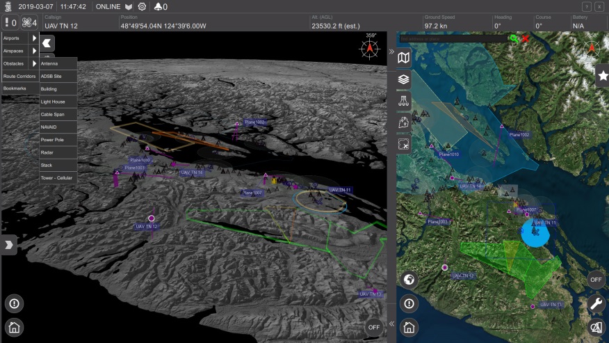
    Kongsberg Geospatial in Ottawa, Canada has developed location visualization software tools that are used for air-traffic control, command and control, and air defense applications. The company has several decades of experience in these applications. Its IRIS software was used to support recent UAV oil pipeline inspection operations in Nigeria, providing safety critical airspace deconfliction, supervised by the Nigerian Civil Aviation Authority (NCAA).

    IRIS airspace situational awareness screenshot Photo: Kongsberg Geospatial
    IRIS airspace situational awareness screenshot (Photo: Kongsberg Geospatial)

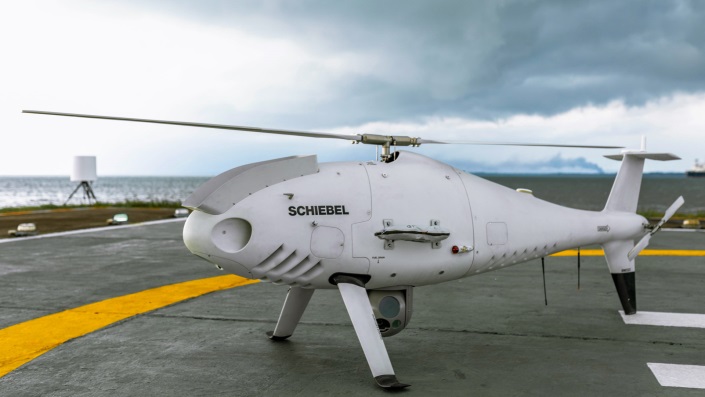
    The pipeline project was undertaken by Aerial Robotix, a UAS services provider in Nigeria, who used adapted Kongsberg software in its control center to demonstrate safe BVLOS operations, and was then able to obtain the necessary permits. A Schiebel Camcopter S-100 UAV with a 200-kilometer BVLOS capability was used for flight inspection, operating both day and night, with real time high-definition payload imagery sent back to the control station.

    Camcopter S-100 prior to BVLOS pipeline inspection flight in Nigeria. Photo: Schiebel
    Camcopter S-100 prior to BVLOS pipeline inspection flight in Nigeria. (Photo: Schiebel)

    Nigeria has a major problem with gasoline theft from pipelines similar to those lines inspected during this project. Recently, 105 people perished in a blast from a ruptured pipe 30 miles north of the city of Umuahia, possibly during scavenging for leaking fuel. It has been claimed that the pipeline had been ruptured by saboteurs earlier, and for the following six weeks villagers had been collecting fuel. Pipeline vandalism is common in Nigeria, even given the risk of fire or explosion, or the risk of prosecution, or even the possibility of being shot on sight.

    Unmanned Companion Fighter Aircraft

    Boeing just unveiled a concept UAV which is apparently aimed at providing an airborne team-partner for manned aircraft. The concept was introduced at the Australian International Airshow by the Australian Minister for Defense, the Hon. Christopher Pyne MP. The project is slated for a significant R&D investment by the Australian Government and Boeing Australia.

    Boeing Airpower Teaming System. Photo: the Boeing Company
    Boeing Airpower Teaming System. (Photo: Boeing Company)
    Boeing Airpower Teaming System. Photo: the Boeing Company
    Boeing Airpower Teaming System. (Photo: Boeing Company)

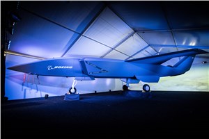
    The concept model has fighter aircraft lines with a projected 2,000-mile range, autonomous capability, and significant intelligence, surveillance and reconnaissance sensor capability. Flying alongside manned fighter/attack aircraft with artificial intelligence simplifying control, the Airpower Teaming System is designed as a low-cost force multiplier.

    The concept includes a pitch for international collaboration offering significant customization so countries can add local content, a key element for any aircraft program designed for off-shore sales.

    XQ-58A demonstrator in flight. Photo: US AirForce
    XQ-58A demonstrator in flight. (Photo: U.S. Air Force)

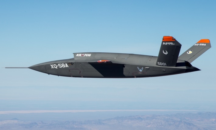
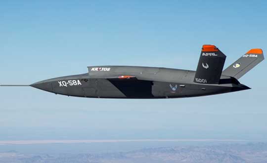
    A day or so after the Airshow (maybe not wanting to be upstaged by Boeing’s announcement?) a release showed up about the first flight of the previously secret XQ-58A Valkyrie demonstrator. This is apparently a program by the US Air Force Research Laboratory (AFRL) partnered with Kratos Unmanned Aerial Systems to develop a UAS which looks to have very similar capabilities to that of the Boeing concept, perhaps at a significantly further advanced stage, with a much more mil-spec UAV sounding name.

    The AFRL indicated that the XQ-58A is part of a Low Cost Attritable Aircraft Technology (LCAAT) (guess that means they don’t much mind losing a few) effort to come up with low-cost force multipliers which can be built quickly using commercial technology and operating from unprepared runways.

    (From the Air Force: “The thought is to develop an inexpensive, configurable and producible on demand air vehicle. A number of military applications can be envisioned for an air vehicle with such a capability. One potential application is to use hundreds or thousands of such units in a campaign to overwhelm an enemy’s air defenses and “punch a hole” to enable higher value, less replaceable [aircraft] to engage or monitor enemy systems. Another potential application is to augment the capabilities of high-value intelligence, surveillance and reconnaissance, systems which may be limited in a specific campaign by distances, quantities, or threats. For all applications, the weapon system is expected to be an air vehicle that would return to base or to a separate location to be recovered. However, because of the mission and because of the low cost, the air vehicle would be attritable, meaning the Air Force would expect and could afford to lose many of the assets.”)

    The current program took 2½ years to get to this flying prototype, which still seems pretty lengthy in terms of today’s commercial UAVs. The first flight from Yuma Proving Grounds in Arizona lasted an hour and a quarter and all went as expected. Five test flights are planned to check out functionality, aerodynamics, and launch and recovery systems. Kratos is perhaps better known for its family of target drones which have been in use by the US and internationally for some time.

    Kratos BQM-177 Navy drone declared operational. Photo: Naval Air Systems Command release
    Kratos BQM-177 Navy drone declared operational. (Photo: Naval Air Systems Command)

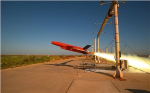
    Kratos Defense & Security Solutions, Inc. announced in early March that its BQM-177A Subsonic Aerial Target (SSAT) has achieved Initial Operational Capability as reported by the US Navy. A Navy statement said “The first site the BQM-177A will be operated from is Pt Mugu, California. The target is capable of speeds in excess of 0.9 Mach and a sea-skimming altitude as low as 10 feet which provides sea-skimming anti-ship cruise missile threat emulation for the US Navy.”

    Parachute System for DJI Phantom 4

    Recent testing of the descent rate of a Phantom 4 equipped with a SafeAir parachute system indicated that this UAV/parachute combination may well meet the FAA’s recently published draft rules for flight over people. The parachute system uses on-board indicators to trigger parachute deployment. ParaZero (manufacturer of the SafeAir UAV parachute system) has developed standards, and promises to provide customers with certification data to support waiver applications for flight over people.

    Wrap-up

    So now we have intuitive software using terrain data and sensor inputs which can provide a visual overlay to supports BVLOS flights, concepts designs and prototypes to support the ‘Loyal Wingman’ approach – flying UAVs alongside existing defense aircraft as force multipliers – and advances towards UAV flight over people using certified parachute safety systems.  Just a flavor of the flurry of recent new developments in the world of unmanned aircraft.


  • GPS Caucus forms in Congress

    GPS Caucus forms in Congress

    By: J. David Grossman, GPS Innovation Alliance

    Senators Joni Ernst (R-IA) and Tammy Duckworth (D-IL) joined Representatives Dave Loebsack (D-IA) and Don Bacon (R-NE) in launching the Congressional GPS Caucus in March. This bipartisan, bicameral caucus will elevate the ever-increasing importance of GPS technologies to the U.S. economy and infrastructure. As evidence of that, today more than 3.3 million jobs in the United States rely heavily on GPS.

    Agriculture is front and center in the states and districts these policymakers represent, and the cost savings as well as jobs and family incomes are noteworthy. Nationwide, GPS has led to $8.2 billion in savings through precision agriculture, while yielding increases in grain production across the country. Further, GPS has become an indispensable and reliable part of the country’s national infrastructure. Public and private investment in GPS-based technologies and services have produced a steady stream of innovations, making the U.S. a global leader in the sector.

    The GPS Caucus will prioritize ensuring GPS signals remain continuously available, accurate, reliable and resilient. To better support the long-term health and future of GPS, the caucus plans to host educational briefings and technology demonstrations, in addition to advocating for policies that keep GPS at the forefront. On April 2, these efforts will kickoff with a “GPS 101” educational briefing on the Hill featuring remarks from Senator Duckworth, Representative Loebsack, Colonel Curtis Hernandez, US Air Force Director National Security Space Policy, National Space Council and industry leaders from Deere & Company, Garmin and Trimble.

    To further reaffirm the critical importance of GPS, the GPS Caucus introduced concurrent resolutions in both the Senate and House. The resolutions outline the economic benefits of GPS, totaling more than $68 billion to the U.S. economy each year, and the sectors GPS technology supports, none of which would be possible without the contributions made by the men and women of the Air Force who maintain the GPS constellation.

    As efforts to advance 5G, precision agriculture and smart cities continue, GPS will only become more valuable to modern-day operations and it remains critical that policymakers, companies and industry leaders alike, foster policy that keeps GPS at the forefront.


    Featured photo: Brian Kinney/Shutterstock.com

  • Iono Blob holds back air safety advances

    Iono Blob holds back air safety advances

    Where have all the SBAS gone?

    Space Based Augmentation Systems (SBAS) –  known in North America as the Federal Aviation Administration’s (FAA’s) Wide Area Augmentation System (WAAS) – have been fully operational in one form or another for several years. The FAA’s incremental improvements to integrity, accuracy and reliability in WAAS have brought the system to a point where we have precision en-route navigation for aircraft, and we can also land aircraft using WAAS signals at thousands of airports in the US and in Canada.

    Why not Mexico, which also benefits from the same WAAS coverage? More on that later, as we piece together the many parts of the complex SBAS mosaic.

    SBAS precision approach coverage, May 2016. Graphic: FAA Tech Center, Lockheed Martin, GMV
    SBAS precision approach coverage, May 2016. Graphic: FAA Tech Center, Lockheed Martin, GMV

    Europe benefits from high-accuracy en-route navigation, and there are also hundreds of operational approaches using the European Geostationary Navigation Overlay Service (EGNOS) SBAS.

    In India, the GPS Aided Geo-Augmented Navigation (GAGAN) system provides accurate en-route navigation and approach capability. However, ionospheric disturbance may limit some aspects of performance.

    Japan established the Multi-functional Satellite Augmentation System (MSAS) SBAS, and has benefited from improved en-route navigation, but it’s possible that the more limited geographic distribution of GPS ground reference stations has restricted improvements to approach capabilities.

    But what happened to the International Civil Aviation Organization (ICAO) concept from 2007, supported by all the ‘aviation-going’ countries of the world, that SBAS would evolve and eventually multiple national systems would provide coverage around the rest of the world, maybe even by 2016?

    Countries in Asia, South America, Africa and the continent of Australia all appear to have looked closely into establishing their own SBAS, but nothing seems to have come out of these investigations. Technical issues, cost, and political obstacles have all hindered global SBAS progress.

    The ionospheric challenge. Graphic: GMV and Lockheed-Martin
    The ionospheric challenge. Graphic: GMV and Lockheed-Martin

    Technical Issues. Ionospheric scintillation problems around the Equator seem to be at the root of most technical problems for SBAS. Getting to the required level of probable, bounded system error  is hugely difficult. The iono disturbance ‘blob’ follows the sun around the Equator and wipes out any chance of satisfactory system performance when it passes over Equatorial countries.

    As total electron count (TEC) increases, the ionospheric grid, which most SBAS use to predict ionospheric variation across their geographic area between fixed reference stations, well, it just doesn’t work anymore.

    Cost. The capital cost of building a satellite-based augmentation system and the on-going cost of maintaining a bunch of geographically distributed reference sites, building and launching GEO satellites or renting transponders on someone else’s orbiting asset, establishing, operating and maintaining redundant uplink stations, redundant terrestrial data links, and setting up control systems that collect and create the SBAS uplink message — it  all adds up. Millions and maybe even billions of dollars or equivalent, in total, have been spent by those select countries who could afford their own SBAS. Others named above have lesser financial resources upon which to draw.

    Political Obstacles. One of the trickiest issues is sovereignty: the need for a country to control its own navigation and landing system. This has likely been the source of most resistance to more SBAS systems being set up and shared by bordering countries around the world.

    For a large number of smaller countries, SBAS would only make sense if it was shared across a number of neighboring countries, but that means relinquishing sovereignty to some degree. In several regions of the world a number of geographically adjacent countries don’t particularly like each other, never mind thinking of such sharing/collaboration.

    National sovereignty, by the way, isone of the main reasons that existing satellite navigation systems underpinning SBAS, such as Galileo, GLONASS, IRNSS (now NAVIC), QZSS and of course BeiDou have all been put in place.

    Another problem with potential SBAS sharing across adjacent countries stems from responsibility for liability. Should something not work and an accident ensues from such a malfunction, who’s liable? Mexico seems to have adopted the view that since the US provides WAAS on what could be called an ‘as-is’ basis, then the potential liability issue seems to trump using the system.

    Solutions? Technical issues with the ionosphere may soon be resolved by using dual-frequency L1/L5 airborne receivers that directly calculate their own ionospheric corrections, rather than using the computed SBAS iono grid. If we add in dual-frequency E1/E5a signals from Galileo, things start to get even better. New requirements and prototype equipment are already being developed for dual frequency multi-constellation airborne receivers. Airbus anticipates equipping aircraft with such receivers around 2025. Could this solve the SBAS technical issue for Equatorial countries?

    ARINC (now a UTC/Rockwell Collins company) and SITA (in Europe) have been providing commercial aircraft with operational communications services on a pay-for-use basis for a number of years, and this is notarized as an accepted means of compliance within ICAO policy/requirements:

    From ICAO Doc. 9161, Sec. 3.99: “A group of states or a regional organization might also undertake to operate the augmentation satellite service required, either by themselves or by contracting a commercial or government organization to do so on their behalf.”

    ARINC en-route coverage. Graphic: ARINC
    ARINC en-route coverage. Graphic: ARINC

    Aireon has partnered with NAV CANADA, the Irish Aviation Authority (IAA), Enav, NATS and Naviair, as well as Iridium Communications and Harris Corporation to provide real time ADS-B data (GPS position output from aircraft) to air-traffic control providers. Aireon’s payloads on the new Iridium NEXT Low-Earth Orbit (LEO) satellite constellation will receive aircraft ADS-B messages and relay them to Air Traffic Controllers in real-time.

    There are 66 Iridium NEXT satellites in operation, with significant overlap and redundancy built into the system to enable this safety-of-life service to be provided on a pay-for-use basis to the aviation industry. We could at last know the location of every suitably equipped aircraft in the air, in almost real-time. The ICAO requirement is for an update rate of 15 minutes.

    Inmarsat ADS-C is a similar service available to aircraft on a contracted, pay-for-use basis via Inmarsat GEO satellites.

    Market Solutions. If a substantial company showed up with a worldwide distributed SBAS solution and offered it on a fee for service basis, why wouldn’t countries that are already accustomed to ARINC and SITA pay-for-use communications? The Aireon international aircraft tracking system, to be provided on the same basis, adds to the credibility of such a pay-for-use service.

    So why wouldn’t these accepted services demonstrate to those countries concerned about control and national sovereignty that an SBAS service could be provided on this basis?

    The liability for provision of service sits with the providers, so user countries/airlines would have someone to turn to about liability issues, and there presumably could be contract terms to provide system performance guarantees.

    No huge capital costs, no system to construct, nor staff to operate or maintain, and yet a level of control similar to that which has been around for commercial aircraft communications for decades.

    Would this be of interest to countries that have not yet jumped on the SBAS bandwagon? A definite ‘maybe,’ we could imagine? What’s not to like?

    The punch line to all this is that Lockheed Martin and GMV (Spain) have teamed to challenge these non-SBAS countries with a solution which may appeal.

    Uralla reference test site. Photo: Lockheed-Martin
    Uralla reference test site. Photo: Lockheed-Martin

    To present convincing evidence that it would work, a dual frequency GPS (L1/L2) + Galileo (E1/E5a) reference site has been set up in collaboration with Geoscience Australia and Land Information New Zealand. The reference site is located at Uralla, New South Wales on Australia’s East Coast, where it gathers data demonstrating bounded errors within the operational range which could enable GNSS approach capability.

    L1 (2006) vs. DFMC (2018) SBAS at Bangkok. Graphic: Lockheed-Martin, GMV
    L1 (2006) vs. DFMC (2018) SBAS at Bangkok. Graphic: Lockheed-Martin, GMV

    Another test site in Bangkok, Thailand has demonstrated that existing L1-only SBAS in this area cannot manage this performance (all current SBAS are L1 only), but that with dual-frequency multi-constellation (DFMC) GPS L1/L2+Galileo E1/E5a, the required performance limits could be met.

    Lockheed Martin has also been using the Uralla uplink site to test the uplink and downlink of dual-frequency SBAS-like test messages.

    The Moral of the Story. There are no miracles as yet, but interest in the pay-as-you-go SBAS concept appears to be growing, and the LM/GMV team continues to work to bring their approach to market.

    A large number of countries could well benefit from the high accuracy, integrity and continuity of SBAS service if this all comes together.

  • Per Enge memorial webcast this Saturday

    Per Enge memorial webcast this Saturday

    On Saturday, Nov. 10, Stanford colleagues of Professor Per Enge will host a celebration of his life. A live webcast of the event will be available here at  at 1 p.m. Pacific Standard Time.

    The video will be available afterwards on this site.

    GPS World extends this invitation to join Per’s family and friends in celebrating the wonderful life that he led and the extraordinary impact he had on those around him. Guests at the live event will be invited to share their favorite memories.

    The following statement was recently read into the minutes of the Stanford Faculty Senate:


    Per K. Enge, the Vance D. and Arlene C. Coffman Professor in the School of Engineering and one of the world’s foremost experts in GPS technologies, passed away on April 22, 2018, at his home in Mountain View, California. He was 64.

    Per Enge, Professor and Director, Stanford university Center for Position Navigation and Time
    Per Enge, Professor and Director, Stanford University Center for Position Navigation and Time. (Photo: Stanford University)

    Per was born Oct. 29, 1953, in Bergen, Norway. He immigrated at the age of 2 to the United States with his father and mother.

    He earned his B.S. in electrical engineering at the University of Massachusetts at Amherst in 1975 and his MS and PhD at the University of Illinois Urbana-Champaign in 1979 and 1983, respectively. He met his wife of 38 years, Elaine, while at UMass. His son, Nick, a Stanford graduate and now a lecturer at the University of Texas at Austin, said that despite his academic upbringing, his dad was a middling student until Elaine introduced him to the library at UMass, where she was most often found.

    While pursuing his advanced degrees, Per worked in industry, where he first gained experience using radio signals for terrestrial navigation. He then took a position as assistant professor at Worcester Polytechnic Institute, where he designed a radio-navigation positioning system that today has more than 1.5 million marine and land users. He also started to work on augmenting GPS so that it could be safely used for aeronautical navigation. Due to this effort he was recruited by Stanford University for a one-year visiting professorship in 1993 that was ultimately extended to full professorship.

    While at Stanford, Per became one of the FAA’s most trusted advisors on the provision of aircraft guidance. He oversaw the development of two different systems that today allow airplanes to safely determine their positions within meters regardless of the weather conditions.

    Per was a member of the National Academy of Engineers, a Fellow of the Institute of Navigation, and a Fellow of the Institute of Electrical and Electronics Engineers.

    Per is particularly remembered as a teacher and mentor. He designed a freshman course in electric cars and aircraft and helped launch a popular massive open online course (MOOC) for the GPS community outside Stanford. He leaves behind a strong legacy of more than 40 Ph.D. students, co-workers and colleagues who have been inspired by his genuine joy in being able to work in such an exciting field.

    Per is survived by his wife, Elaine, of Mountain View, and a son, Nick, of Austin. In lieu of flowers, donations in Enge’s memory can be made to a new graduate student scholarship fund under the Stanford department of Aeronautics and Astronautics. Donations can be made at https://gps.stanford.edu/resources/giving


  • GEO 5 joins WAAS, giving FAA better coverage across US

    The Federal Aviation Administration’s Geosynchronous Earth Orbiting 5 Wide Area Augmentation System (WAAS) navigation payload, developed by Raytheon’s Intelligence, Information and Services business, is now operational and fully integrated into the WAAS network.

    The GEO 5 payload joins two others already on orbit in correcting GPS satellite signal ionospheric disturbances, timing issues and minor orbit adjustments, giving users increased coverage, improved accuracy and better reliability, Raytheon said.

    “GPS alone can’t meet the FAA’s stringent requirements for accuracy, integrity and availability,” said Matt Gilligan, vice president of Raytheon’s Navigation, Weather and Services mission area. “The WAAS network corrects even the slightest errors, and that provides peace of mind when it comes to safety of flight.”

    In operation since 2003, WAAS increases GPS satellite signal accuracy from 10 meters to 1 meter, ensuring GPS signals meet rigorous air navigation performance and safety requirements for all classes of aircraft in all phases of flight, Raytheon added.

    WAAS provides precision navigation service to users across the United States from Maine to Alaska, as well as portions of Canada and Mexico.

    For aviation users, WAAS offers pilots more direct flight paths, precision airport approaches and access to remote landing sites without depending on local ground-based landing systems.

    Raytheon is the system integrator on the GEO 5 system, which includes a WAAS navigation payload on Eutelsat’s GEO satellite, two ComSAT ground sites and SED Systems specialized equipment.

  • In memoriam Per Enge

    With great sadness we must report that Per Enge passed away on April 22, at home and surrounded by family. Per was a genial friend and colleague to many, and a pillar of the PNT community. He is greatly missed by all.

    At the culmination of his long, fruitful career he served as the Vance and Arlene Coffman Professor of Engineering at Stanford University, where he also directed the Stanford Center for Position Navigation and Time.

    For many years he conducted research funded by the Federal Aviation Administration, directed at safe and secure air navigation and leading to development of the Wide Area Augentation System (WAAS) and Local Area Augmentation Systems (LAAS). WAAS became fully operational for aviation in the United States in 2003 and is currently carried by more than 110,000 aircraft; similar systems have been deployed in Europe, Japan and India.

    Per Enge at National Cheng Kung University (courtesy Shau Shiu Jan).

    He received the Kepler Award from the Institute of Navigation in 2000 and was inducted into the GPS Hall of Fame by the U.S. Air Force in 2012. He served as a member of the Space-Based Position Navigation and Time Federal Advisory Committee since 2007. In 2013 he received the GNSS Leadership Award for Signals from this magazine, for signal design including national differential GPS, satellite-based augmentation systems, and alternative positioning, navigation and timing sources. He co-wrote Global Positioning System: Signals, Measurements, and Performance.

    Always an educator, Per served as instructor, mentor and gentle encourager of many, many Ph.D. and other graduate-level students at Stanford who have gone on to distinguished careers of their own. In a lifetime marked by great achievements, this is perhaps his greatest and ultimately will be the most far-reaching.

    Born in Norway and brought to the U.S. at age 2, he received a B.S.E.E. from the University of Massachusetts and M.S.E.E. and Ph.D. degrees from the University of Illinois.

    Speaking at GPS World dinner, accepting Signals Leadership 2013 award. (Photo: GPS World file)

    In remarks on accepting the GNSS Leadership Award for Signals, Per cited Faflick’s theorem, “that you will never ever work on any projects that are both interesting and important.” After calling out both GNSS and WAAS as exceptions to the theorem, he identified a third outlier: spoofing.

    “Today’s e-security is based on three security factors: what we know (passwords), what we carry (key fob), and what we are (fingerprints, iris scan). And it is not enough. To meet this challenge, we need to rejuvenate the original security factor: location. In the past, transactions were secured by our presence. In the world of e-commerce, this factor has disappeared, and we must use GNSS to approximate this ancient and effective security factor.

    “All of this will require the best effort of this precious community of ours.”

    Further biographical details are available in an article published by the Stanford News. Among the tributes included there is this one by Brad Parkinson, who recruited Enge to Stanford in the early 1990s. “Anyone who works in GPS is aware of Per and his influence. He was just an intellectually talented person who could understand many scientific nuances and integrate them in ways others could not.”

    Teaching the massive online open course.

    The article also reminds us that he co-originated and co-taught, with Frank van Diggelen, a massive open online course to share GPS knowledge with a worldwide audience, far beyond Stanford’s walls. Titled “GPS: An Introduction to Satellite Navigation, with an interactive Worldwide Laboratory using Smartphones,” it enrolled 31,000 people from 192 countries.  It is available here.

    Per’s Stanford colleagues Sherman Lo, Todd Walter and Sam Pullen assisted GPS World with this article and provided these photos from personal archives. The Stanford group is working on setting up a scholarship in Per’s name.  More information on it and how to support it will be on the SCPNT website once it becomes available.

    Frank van Diggelen has sent further photos, below.

    At the Stanford GPS Lab with colleagues from Stanford and DLR (German aerospace agency).


    Dinner discussions with US-EU bilateral group.
    With Alan Chen, Sherman Lo and an early spectrum image of GIOVE-A (or Galileo).
    Visiting Neuschwanstein Castle in Bavaria after 2005 European Navigation Conference.
    At the Stanford Center Position, Navigation and Time, which he co-founded in 2005.
    Team China Consumers at GPS World dinner 2010. The winning team in the Grand Game of GNSS.
    Fierce “opponents” (examiners) for Ph.D. defense of Ignacio Fernández Hernández of EC/Galileo. Aalborg University, Denmark.
    Prepared to come aboard in Kobenhavn.
    The co-authors of Global Positioning System: Signals, Measurements, and Performance (with Pratap Misra).


    A road warrior for GNSS.


    Faculty of the GNSS Summer School at Svalbard, Norway (Arctic Ocean, 78.7° N).


  • GSA and Thales launch EDG²E for aviation navigation with Galileo

    GSA and Thales launch EDG²E for aviation navigation with Galileo

    The European GNSS Agency (GSA) has officially launched the equipment for dual frequency Galileo, GPS and EGNOS project (EDG²E) with a consortium led by Thales. The four-year project intends to develop a dual-frequency multi-constellation receiver, enabling enhanced navigation capabilities, support standardization and certification preparation, and facilitate the expected increase in air traffic, both in Europe and globally.

    The prototype EDG²E receiver use GPS and Galileo signals as well as those from the European SBAS multi-constellation EGNOS. The project aims to achieve a prototype demonstration by 2021. At the end of the EDG²E project, the first SBAS dual-frequency GPS+Galileo receivers for aviation will be ready for final development and use in the aviation sector and in other safety-critical applications. Fully achieved receivers are foreseen to be installed in commercial aircraft by 2025.

    EGNOS, certified for use in aviation since February 2011, is developing its own next generation, called EGNOS V3, to further enhance performance by complementing both the EU Galileo and the US GPS satellite navigation constellations.

    “EGNOS v3 will provide aviation users with an increased quality of services, better accuracy and extended coverage area among other key performance indicators” said Jean-Marc Pieplu, GSA head of the EGNOS Services Programme. “Fundamental Element Programme is a medium that supports development of terminals and antennae fostering use of E-GNSS in all domains. In this perspective,EDG²E is an important step for GSA as it will contribute to availability of high technology products on the aviation market, taking benefit of Dual Frequency Multi Constellation feature offered by EGNOS v3.”

    The consortium includes Thales, Thales Alenia Space and ATR, as well as contributions from Dassault Aviation and the French Civil Aviation Authority.


    Feature image courtesy of the European Space Agency (ESA).

  • Korea will launch its own satellite positioning system

    Korea will build its own navigation satellite system by 2034, providing independent positioning and navigation signals over an area spanning a 1,000-kilometer radius from the country’s capital, Seoul.

    The Ministry of Science and information and communications technology (ICT) announced that it would finalize a plan for the Korean Positioning System (KPS) at a Space Committee meeting on Feb. 5.

    According to a preliminary statement from the Ministry of Science and ICT, the KPS initiative will develop a ground test in 2021, core satellite navigation technology by 2022 and begin actual satellite production in 2024. The system will comprise a total of seven navigation satellites, three of them geostationary above the Korean Peninsula.

    Figure from the 2016 paper shows a conceptual view of real-time WADGPS operation. The reference station transmits observation data at 1 Hz frequency to the master station. The master station is operated in real time and creates correction information and basic integrity information thereby configuring a message. A message is sent to the satellite communication simulation device according to its own transmission protocol. The satellite communication simulation device performs broadcasting of WADGPS correction information into the L1 band. A message created in every sec is coded with reserved GPS PRN C/A code and modulated with L1 frequency. Since additional correction information transmission medium such as geostationary orbit satellite or pseudolite is not considered in this study, radio frequency (RF) signals are created using simulation devices and performance was verified while connecting the signal with user receivers via cable. Additionally, a commercial communication network was used to transfer correction messages in order to verify user performance, which is located remotely. (Image: Korean Journal of Positioning, Navigation, and Timing)
    Figure from the 2016 paper shows a conceptual view of real-time WADGPS operation. The reference station transmits observation data at 1 Hz frequency to the master station. The master station is operated in real time and creates correction information and basic integrity information thereby configuring a message. A message is sent to the satellite communication simulation device according to its own transmission protocol. The satellite communication simulation device performs broadcasting of WADGPS correction information into the L1 band. A message created in every sec is coded with reserved GPS PRN C/A code and modulated with L1 frequency. Since additional correction information transmission medium such as geostationary orbit satellite or pseudolite is not considered in this study, radio frequency (RF) signals are created using simulation devices and performance was verified while connecting the signal with user receivers via cable. Additionally, a commercial communication network was used to transfer correction messages in order to verify user performance, which is located remotely. (Image: Korean Journal of Positioning, Navigation, and Timing)

    Korea currently relies on the U.S. GPS system, which has suffered repeated local area jamming emanating from North Korea.

    “As the GPS becomes a necessity in everyday life, broken signals for any reason can set off a nationwide chaos,” said an official for satellite navigation at the Korea Aerospace Research Institute (KARI).

    Officials stated the the KPS will also improve  available un-aided accuracy of GPS in its service area from about 10 meters now to less than one meter.

    “Advanced nations are trying to secure strong GPS capabilities by sending up satellites to prevent a chaos that can take place while they depend on other nations’ satellites,” stated the KARI spokesperson.

    The initiative appears to be separate from the Korean Wide Area Differential GPS System, whose development was the subject of a 2011 paper presented at the Institute of Navigation (ION) International Technical Meeting. The abstract for that paper stated:

    “[The] project is scheduled for 2010 to 2014 under the contract with the Ministry of Land, Transport and Maritime affairs (MLTM). After that, Korea will launch a geostationary multifunctional satellite with a navigation payload which will be broadcasting augmenting signals for GPS.”

    In March 2016, the Korean Journal of Positioning, Navigation, and Timing published a paper titled “Performance Analysis of WADGPS System for Improving Positioning Accuracy,” by Hyoungmin So , Jaegyu Jang, Kihoon Lee, unpyo Park and Kiwon Song. Its conclusion section stated:

    “In this paper, configuration of observation reference stations and master station and initial experiment results were presented to verify accuracy correction performance of the WADGPS. The wide area correction algorithm was implemented using eight reference stations and one master station. For the initial performance verification, static and dynamic experiments were conducted. The experiment result showed that the static experiment had a horizontal accuracy performance with a level of 1 m (95 percent). In the dynamic experiment using a vehicle, performance degradation occurred compared to that of static experiment. The reason for this was due to the measured value error at the user receiver caused by multipath and visibility limitation. In summary, the implementation and performance of the algorithm of early stage were verified. For the future study, user operation characteristics will be considered and additional performance analysis on created correction information will be conducted.”

  • U.S. Air Force jamming GPS in Southwest sky this week and next

    The U.S. Air Force is intermittently jamming its own GPS signals over southern Nevada and Utah this week and next as part of a massive air-to-air combat training exercise, Red Flag 18-1, based out of Nellis Air Force Base in Nevada. The jamming aims to challenge aircrews and their weaponry under realistic fighting conditions. The Air Force has warned that navigation systems including those found in commercial flights may be disrupted or jammed completely across the southwest U.S. during that time, ending February 16. So far no major commercial airline disruptions, flight delays or re-routings have been reported.

    The U.S. military, heavily and perhaps overly reliant on GPS, is developing a range of position, navigation, and timing (PNT) technologies being to help overcome the loss of GPS during combat, an increasingly likely scenario now and in years to come. Some have speculated that this year’s exercise specifically has in mind a possible conflict on the Korean Penisula. GPS jamming has regularly emanated from North Korea over the past several years.

    “We’re trying a few new and different things with Red Flag 18-1,” said Col Michael Mathes, 414th Combat Training Squadron commander. “This primarily is a strike package focused training venue that we integrate at a command and control level in support of joint task force operations. It’s a lot of words to say that we integrate every capability we can into strike operations that are flown out of Nellis Air Force Base.”

    The exercise, which the Air Force conducts annually, typically involves a variety of attack, fighter and bomber aircraft with added participation from the U.S. Navy, U.S. Army, Marine Corps, Royal Australian Air Force and Royal Air Force. This year’s Red Flag is the largest in the exercise’s 42 year history.

    Nellis Air Force Base in southern Nevada. (Image: USAF)
    Nellis Air Force Base in southern Nevada. (Image: USAF)

    Affected Areas. “Arrivals and departures from airports within the Las Vegas area may be issued non-Rnav re-routes with the possibility of increased traffic disruption near LAS requiring airborne re-routes to the south and east of the affected area,” stated an Air Force bulletin. “Aircraft operating in Los Angeles (ZLA) center airspace may experience navigational disruption, including suspension of Descend-via and Climb-via procedures. Non-Rnav SIDs and STARs may be issued within ZLA airspace in the event of increased navigational disruption. Crews should expect the possibility of airborne mile-in-trail and departure mile-in-trail traffic management initiatives.”

    Alternate Capabilities. Many Air Force planes have onboard inertial navigation systems, using accelerometers, gyroscopes, and magnetic sensors to continuously calculate position without GPS signal data, as well as at a higher hertz rate. When available, GPS signals can be used to correct inertial calculations, which tend to drift over time. Fighter planes can also use AESA-scanned array radars teamed with an inertial system for navigation over short ranges. Aircraft electro-optical and infrared sensors can also read terrain over short distances to provide additional navigation.

    If strike aircraft have reliable communications or datalinks, other aircraft such as E-8 JSTARS, flying outside the GPS-disrupted zone, may be able to relay position and targeting information. Some missiles carried by strike aircraft have laser-guiding instead of or in addition to GPS-guiding.


  • Next-generation EGNOS to combine Galileo, GPS for aviation

    Next-generation EGNOS to combine Galileo, GPS for aviation

    Satellite-based augmentation systems worldwide. (Image: ESA)

    News from the European Space Agency

    The next generation of Europe’s satellite navigation overlay service, EGNOS, will combine use of GPS and Galileo signals to improve accuracy and robustness of navigation for air traffic and other uses where lives are at stake.

    A contract was signed Jan. 26 at ESA’s technical centre in the Netherlands for the second  generation  of the European Geostationary Navigation Overlay Service, EGNOS V3, planned to enter service in 2025.

    ESA Director of Navigation Paul Verhoef signs the EGNOS V3 contract Jan. 26 with Senior Vice President of Airbus Defence and Space, Mathilde Royer Germain. (Photo: ESA)

    ESA Director of Navigation Paul Verhoef signed the contract with the senior vice president of Airbus Defence and Space, Mathilde Royer Germain,  in the presence of senior managers of the European Global Navigation Satellite System Agency (GSA) and of the European Commission.

    This improved version of the service will take advantage of in-operation Galileo signals as well as new frequencies from an improved class of GPS satellites. Use of the L5 second frequency will improve service robustness against errors and propagation delays caused by the ionosphere, an electrically active outer layer of Earth’s atmosphere.

    “This will be the first such regional satellite augmentation systems worldwide to employ dual frequency, GPS and Galileo signals,” comments Didier Flament, overseeing EGNOS development for ESA.

    For aircraft with the latest avionics, EGNOS V3 will be able to guide them accurately and safely down to Category 1, a 10 m Vertical Alert Limit (also called Cat1 Autoland capability), while also providing legacy users equipped with current avionics a more robust version of the current LPV200, or 35 m vertical limit vertical guidance service.

    As well as improving services for civil aviation, the plan is to introduce new services for other sectors such as maritime navigation and rail, and extend service coverage from the European continent to link up seamlessly with other interoperable augmentation systems worldwide.

    EGNOS is Europe’s other satellite navigation system, next to the global Galileo system.  Comparable to the US WAAS, the Wide Area Augmentation System, and other regional augmentation systems in the rest of the world, EGNOS is an overlay system based on a network of ground stations and transponders on geostationary satellites. These stations gather data on the current accuracy of US GPS signals and embed correction data in the EGNOS signal, which is uplinked via geostationary satellites to EGNOS users.

    The current EGNOS augments the accuracy of GPS signals across Europe and informs users of their current reliability level within six seconds. EGNOS belongs to a family of systems called Satellite Based Augmentation Systems (SBAS); the EGNOS V3 second generation will augment both GPS and Galileo.

    Designed against global standards set by the International Civil Aviation Organisation, EGNOS began offering its Open Service for non-safety-of-life uses in October 2009. In March 2011 its Safety-of-Life Service became available for aircraft navigation.

    Dozens of European airports are today employing EGNOS for vertical guidance approaches, as an economic alternative to ground-based infrastructure, like Instrument Landing Systems. It is estimated that that around 110 000 aircrafts worldwide are today equipped and using SBAS systems.

    The development of satellite-based augmentation systems around the world is being coordinated in particular by the international SBAS Interoperability Working Group, which last week held its 33rd meeting at ESA’s centre in Madrid, chaired by ESA and the US Federal Avigation Authority, joined by current or planned service providers from Africa, Australia, Canada, China, India, Japan, Russia and South Korea.

    Initiated by ESA in cooperation with the EU and Eurocontrol, the EGNOS Exploitation phase is managed by GSA and funded by the EU. ESA manages the EGNOS development under a working arrangement signed between GSA and ESA.

  • Airborne GNSS receivers: Who’s doing what?

    Airborne GNSS receivers: Who’s doing what?

    Rockwell Collins new generation GPS-4000-100 receiver

    It’s still exceptionally difficult to qualify GNSS receivers for airborne use so there are only a few existing suppliers.

    They include CMC Electronics with its line of OEM and enclosure products, Rockwell Collins with a new generation of airborne receivers just entering the market, Thales in Europe continuing to offer ARINC standard and multi-mode packaged receivers, Garmin still leading the panel-mount market for business aviation, Trimble/Ashtech continuing to promote its GPS/GLONASS airborne receiver, and newer entrants including Aspen/Accord with the NexNav GNSS line, and Avidyne with a home-grown embedded receiver in its flight management systems.

    It’s been a while since we reviewed the status of certified airborne receivers, and I was prompted to do so by news that Rockwell Collins has a new generation of receiver which has just received Technical Standard Order (TSO) approval from FAA.

    Rockwell Collins has fielded GPS products for 20+ years, and the GPS-4000S — with SBAS capability — has been fielded for more than 8 years, so parts obsolescence may become an issue. With new constellations, and with more countries implementing Space Based Augmentation Systems (SBAS), the 10 channel + 2 SBAS design needed an update. So Rockwell Collins undertook a bold step to develop and certify a radically new architecture for airborne applications — a software defined receiver.

    Some Members of the Rockwell Collins Navigation Center of Excellence, in Melbourne FL (L-R); Jeremy Kazmierczak – Senior Systems Engineer; Eyal Wilamowski – GNSS Project Engineer; De Yao – Senior Electrical Engineer; Angelo Joseph – GNSS Architect, Technical Project Manager; and Principal Systems Engineer Vikram Malhotra – Senior Systems Engineer

    A multi-frequency prototype first came together during two years of intense work by a couple of individuals, led by Angelo Joseph, an ex-NovAtel Aviation Group engineer with 15 years of GNSS design experience. When this proof-of-concept receiver demonstrated the required capability, a new GNSS receiver team was put together in Melbourne, Florida, to develop a fully qualified receiver, designed and built to stringent airborne standards.

    Over the next six years, hardware was proven to meet performance, environmental, electrical, safety, high-integrity and reliability standards, and software was carefully developed and tested to meet the highest aviation qualification requirements — referred to as “Level A.”

    In the process, a number of patents were generated — two have so far been approved in the United States:

    • Low-cost high integrity integrated multi-sensor precision navigation system, US 9513376 B1
    • Universal channel for location tracking system, US 9702979 B1

    The universal-channel technique enables the new receiver  to be configured to track any satellite navigation signal on all 14 + 4 SBAS channels (ultimately, this GNSS engine is anticipated to be able to track 100+ GNSS satellite signals), so the receiver is ready for when other constellations are approved for airborne navigation — for instance, European approval for Galileo use may be high on the list of new capabilities.

    CMA-6024 GPS/SBAS/GBAS sensor

    The new receiver is capable of LPV (localizer performance with vertical guidance) precision approaches to CAT I (down to ~200ft height in ~1/2 mile visibility). It features combined Required Navigation Performance (RNP) and approach capability, 10-Hz deviation output computations (20-Hz outputs), plug-and-play replacement for existing Rockwell Collins GPS receivers. It is Automatic Dependent Surveillance (ADS-B) compliant and has fast cold-start (<2 mins @ low SNR).

    With production spooling up in Melbourne, Florida, it is available now for installation on business and regional aircraft.

    An additional TSO application is underway to enable anticipated installations on Airbus and Boeing commercial transport aircraft. Work on the Rockwell Collins Next Generation Multi-Mode Receiver, the GLU-2100, is well advanced with an estimated availability at the end of this year.

    In Europe, Thales markets the TopStar-C certified GNSS receiver solution for aircraft and helicopter navigation and approach, providing LPV, RNP and ADS-B, with Ground Based Augmentation System (GBAS) capability promised in the near future. Compliant with all these latest navigation functions, TopStar-C is available as both standard fit (installed as basic fit on a new aircraft) and for retrofit on aircraft and helicopters alike.

    CMA-4124 GNSSA Precision Approach Receiver

    The Thales Multi-Mode Receiver (MMR) is part of the TopFlight Line, which includes comprehensive solutions for communication, navigation and surveillance. The MMR is configured with GNSS landing system (GLS) and navigation capability, Instrument Landing System (ILS) and Microwave Landing System (MLS) receivers in one package.

    ILS still provides Cat III precision landing system (effectively 700 ft visibility of the runway down to 50 ft) capability at a few key airports where severe weather can really disrupt scheduled airline operations. Nevertheless, ILS may encounters integrity problems due to FM interference and multipath reflection, which may degrade landing capabilities under low-visibility conditions — just when its most needed. MLS can provide Cat. III B (effectively 600 ft visibility of the runway down to 35 ft) landing alternative to ILS, but is fielded at very few airports.

    Meanwhile, GLS is part of the international strategic plan to provide precision approach capability worldwide to an increasing number of runways. So airlines may soon have a number of precision-landing options at airports around the world — ILS, MLS or GLS — and the Thales MMR provides all three capabilities.

    Garmin GTN-650 panel-mount Nav/Comm System

    CMC Electronics introduced the CMA-6024 GPS Satellite Based Augmentation System and Ground Based Augmentation System (SBAS/GBAS) CAT-l/ll/lll Precision Approach Solution at the National Business Aircraft Association show in November 2016. CMC has been in the business of supplying certified GPS receivers for commercial air transport, business aviation and helicopter markets, either directly or through Honeywell and other partners for over 35 years — almost as long as GPS has been around! The CMC family of airborne receivers also has another connection with NovAtel — they were developed as a collaborative effort with NovAtel and incorporate patented Narrow Correlator signal tracking technology.

    The CMA-6024 aviation GPS/SBAS/GBAS sensor has an embedded VHF Data Broadcast (VDB) receiver and an integrated GPS navigation sensor, is self-contained, and fully certified Precision Approach and navigation GBAS/GLS solution, certified to Design Assurance Level A.

    Garmin GPS/Nav/Comm/Multi-Function Display.

    The CMA-6024 provides a navigation solution that is fully compliant with Automatic Dependent Surveillance-Broadcast (ADS-B) and Required Navigation Performance (RNP). It comes with SBAS Localizer Performance/Localizer Performance with Vertical Guidance (LP/LPV) and GBAS Global Navigation Satellite System Landing System (GLS) GAST-C/D Precision Approach guidance for all aircraft. And it meets or exceeds the most stringent environmental requirements set out in RTCA/DO-160G, meeting additional requirements for specific aircraft, such as higher vibration levels for helicopters.

    CMC’s family of GPS products includes the CMA-5024 GPS Landing System Sensor that meets the requirements for Instrument Flight Rules (IFR), civil certified GNSS, and also the CMA-4124 OEM GNSSA receiver card for embedded applications.

    An SBAS/WAAS-certified, 15-channel GPS with 5-Hz outputs is embedded in the Garmin GTN-650 Nav/Comm unit, enabling GPS-guided LPV glide-path instrument approaches down to 200 ft. The system also includes VHF navigation capabilities, with a 200-channel VOR (VHF Omnidirectional Range) and ILS receiver for approaches with ILS localizer and glideslope. VOR navigation using the extensive ground VOR beacon system uses radial direction and distance to each VOR beacon within receiver range.

    FreeFlight FMS/GPS

    In addition, course deviation and roll steering outputs may be coupled to compatible autopilots so that IFR flight procedures may be flown automatically. And, when coupled with a flight display and compatible autopilot, the aircraft can fly fully coupled missed approaches, including heading legs as well as holds and search and rescue patterns.

    In 2015, Aspen Avionics acquired Accord Technology, an Indian company which claims to have developed the first GPS WAAS airborne sensor to be authorized under US FAA TSO-C145c. These receivers are now marketed as the ‘NexNav’ product line. This receiver was apparently the first to comply with FAA AC20-165A for ADS-B GPS position source and is also sold as an OEM GPS SBAS card-level receiver authorized to TSO-204.

    There are currently three NexNav receiver versions:

    • Mini (TSO-C145c SBAS Class Beta-1 only)
    • Max (TSO-C145c SBAS Class Beta -1, -2, -3) and
    • Micro-i GPS SBAS for TSO-C199 TABS for aircraft and experimental aircraft.
    SBAS/GNSS (WAAS/GPS) 1201 Sensor

    All NexNav GPS WAAS receivers are compatible with other SBAS systems around the world, including the European EGNOS, Japanese MSAS and Indian GAGAN.

    FreeFlight also markets two GNSS sensors and a suite of aircraft avionics.

    The 1203C sensor houses a high-performance 15-channel GPS engine with advanced interference protection and quick update rates, and is designed for business, regional, airline transport and heavy rotary-wing aircraft. The 1203C is certified to TSO-C145c and meets position source requirements for ADS-B and Required Navigation Performance (RNP) and other L-NAV operations. Another 1201 Sensor GNSS is specifically for General Aviation aircraft.

    Bendix/King KSN 770 Flight Information Management System

    Bendix/King GNSS navigation capability, like other General Aviation avionics suppliers, is often buried within a cockpit display system that serves to tune radios, and display information from weather radar, Enhanced Ground Proximity Warning System (EGPWS), XM Datalink Weather, Terrain awareness and warning System (TAWS) and Traffic Collision Avoidance System (TCAS).

    Nevertheless, the KSN 770 features Wide Area Augmentation System (WAAS) and Localizer Performance with Vertical Guidance (LPV), and is specified as a “WAAS GPS enroute and approach navigation system.”

    Ashtech, now a Trimble subsidiary, still lists the venerable GG12 OEM GPS/GLONASS receiver on its website, now somewhat updated to include SBAS as the GG12W.

    Ashtech is careful to describe its OEM receiver as “capable of being qualified” within a TSO-ed FMS systems — presumably the approach has been to provide all the required qualification data to integrator companies, who include this receiver within the FMS as the GNSS navigation and approach receiver. The integrator then submits the Ashtech data to FAA to support their system TSO application.

    Avidyne now integrates its own in-house-developed GNSS receiver into its line of cockpit mount FMS and related GNSS navigation and approach systems. And here there is another connection with Angelo Joseph — his work at Avidyne before he went to Rockwell Collins was to develop this Avidyne receiver to replace a bought-out embedded OEM GNSS receiver. The FMS has been certified using this new receiver to TSO-C146d — Stand-Alone Airborne Navigation Equipment using GPS augmented by WAAS, including Airborne Supplemental Navigation Equipment using the Global Positioning System (GPS) — Gamma 3.

    Avidyne IFD540 display

    There are clearly other companies who supply avionics for GA and Commercial Air Transport aircraft, but this article has attempted to capture a cross-section of GNSS offerings. Other notables include Sagem/Safran in France, Universal Avionics in Tucson, and quite possibly several others that we will no doubt hear about shortly!

    As aviation agencies move towards adding the use of other constellations beyond GPS into approved, international navigation standards, there surely has to be significant change across the board for aviation as a whole as improved integrity and availability provide more options and capability. The existing avionics suppliers should be able to maintain market by offering more capability, and there might even be more opportunity for new entrants to come into the market with disruptive products, but for sure the future looks good for the industry.

  • Martek deploys Centrik aviation management for BVLOS UAVs

    Martek Marine has deployed the Centrik system to manage its UAS operation, the same system used by major airlines.

    Centrik is a cloud-based aviation management software solution specifically tailored for RPAS/UAS operations. It encompasses all aspects of operations: safety, quality, compliance and risk management, while providing comprehensive reporting functions, the company said.

    Centrik gives visibility of every single electronic flight bag and enables sharing of audit information direct with the Civil Aviation Authority or any interested third parties.

    It maintains a complete training record for every single member of staff, allowing us to see instantly who has which qualification and who needs to renew their training.

    It also compiles all assessment results, delivers alerts management when training certificates are about to expire and provides handy checklists of core competencies.

    Martek UAS.

    Pushing UAS capabilities to enable a multitude of compelling use cases can only happen with the approval of the relevant Aviation Authorities who are requiring us to demonstrate the highest level of operational standards and business oversight.

    “Thinking that you can manage a major UAS operation with old fashioned spreadsheets, folders and emails is fundamentally flawed — akin to putting cartwheels on a Tesla,” said Paul Forster, head of UAS Operations. “Investing in Centrik is another statement of our intent to be the world-leader in UAS operations, to compliment our well documented $multi-million investments so far in the world’s best maritime UAS/RPAS.”