Tag: digital edition

  • On the road to autonomous vehicles

    On the road to autonomous vehicles

    SBG Systems’ INS Ellipse-D powers Leo Drive’s autonomous car.
    SBG Systems’ INS Ellipse-D powers Leo Drive’s autonomous car.

    The evolution of autonomous vehicles has been a fascinating journey, transforming from science fiction to reality over the past few decades. Most modern cars on roadways worldwide have varying levels of autonomy, ranging from Level 1 features, such as cruise control, to Level 5 fully autonomous features, including the ability to monitor roadway conditions and perform safety-critical tasks without human intervention.

    In recent years, several technology and automotive companies have recognized the benefits of autonomous vehicles and their potential impact on communities and industries worldwide. In response, industry leaders have supported autonomous vehicle innovation and adoption by offering new products and working closely with educators, nonprofit organizations and other groups that aim to use autonomous solutions to connect the world.

    New solutions combining GNSS technology with inertial navigation systems (INS) have emerged to increase autonomous operation efficiency and development. GNSS/INS serves as the foundation for various autonomous operations, ranging from self-driving vehicles on public roads to sophisticated port machinery. In urban public transportation, the accuracy of GNSS signals can be compromised by tall buildings and signal interference, leading to potential errors in navigation. Meanwhile, in the specialized vehicle sector, the lack of extensive experience in complex environments poses challenges, with unpredictable issues potentially arising.

    As we enter a new era of advanced autonomy, companies such as SBG Systems and Septentrio, along with their partners, are pushing the boundaries of what is possible in self-driving technology. SBG Systems and autonomous vehicle developer Leo Drive are integrating GNSS/INS systems, multiple cameras and lidar sensors into Leo Drive’s autonomous platforms for precise navigation and accurate positioning data for safe and efficient operations in urban applications.

    Septentrio and Smart yoUr Mobility Inc. (SUM) also are making significant strides in advancing autonomous operations. The companies have formed a strategic partnership to develop and implement a multi-sensor fusion system for autonomous driving. This collaboration aims to enhance self-driving vehicles’ accuracy, reliability and safety by integrating data from various sensors, including lidar, cameras and radar.

    Additionally, recognizing the need for precise positioning in complex environments — such as ports packed with equipment and steel containers — SUM and Septentrio are working together on a solution that ensures accurate positioning and reliable autonomous operations in challenging port operations.


    Enhancing precision and performance

    Leo Drive offers scalable software and hardware solutions, providing a comprehensive, end-to-end service for integration into autonomous systems. The company’s mission is to enhance the accessibility and adoption of autonomous technology across various sectors, including UAVs, unmanned ground vehicles (UGVs) and autonomous driving systems.

    To operate its autonomous vehicles effectively, Leo Drive was in search of an INS compatible with its existing platforms and robust enough to meet real-time processing demands in dynamic environments. The company also wanted an INS with dual-antenna RTK capability to offer consistently high precision in positioning and orientation, leading the company to SBG Systems’ Ellipse-D, a dual-antenna RTK INS.

    Leo Drive integrated the Ellipse-D INS into its autonomous test vehicle, a passenger car converted for autonomous operations. Equipped with GNSS/INS systems, multiple cameras and lidar sensors, the vehicle requires precise navigation and accurate positioning data for safe and efficient operation. This vehicle serves as a critical platform for research and development (R&D) and technology demonstrations.

    The test vehicle is powered by Autoware software, hosted by the Autoware Foundation, a nonprofit organization committed to developing open-source, collaborative software for autonomous vehicles.

    Leo Drive mounted Ellipse-D INS onto its test vehicles using non-ferromagnetic materials to prevent interference and ensure optimal sensor performance. The electrical connections were made via RS-232/422 and CAN interfaces, and custom drivers were used within the ROS2 environment to integrate the Ellipse-D’s real-time data into their sensor fusion algorithms.

    During the integration phase, the SBG Systems’ support team provided ongoing assistance to quickly address any challenges. The SBG Systems Support portal also was valuable, providing comprehensive guidance and troubleshooting assistance.

    Leo Drive’s autonomous car is equipped with GNSS/INS systems, multiple cameras and lidar sensors for precise navigation as well as accurate positioning.
    Leo Drive’s autonomous car is equipped with GNSS/INS systems, multiple cameras and lidar sensors for precise navigation as well as accurate positioning.

    Ellipse-D played a key role in Leo Drive’s Autonomous Vehicle by providing accurate real-time navigation data. Its dual-antenna RTK capabilities ensure orientation data is reliable and supports the vehicle’s complex navigation algorithms. The sensor’s RS-232/422 and CAN connections allowed for easy integration with Leo Drive’s onboard computers. Custom drivers and nodes in the ROS2 environment facilitated smooth communication between the Ellipse-D and other vehicle sensors, enhancing overall system robustness.

    Advanced features for better navigation

    Since integrating Ellipse-D INS into its autonomous vehicle, Leo Drive said it has experienced several significant improvements, including:

    • Improved accuracy: Ellipse-D’s high positioning and orientation accuracy has been instrumental in refining the performance and reliability of Leo Drive’s autonomous systems.
    • Increased efficiency: Ellipse-D’s advanced algorithm enables smoother development processes and more accurate test results, streamlining R&D efforts.
    • Timely support: The comprehensive customer support, including detailed documentation and a responsive technical support team, ensured a seamless integration process.

    Leo Drive identified three standout qualities of SBG Systems that have been critical to its success: exceptional customer support, high-quality products and a user-friendly support portal.

    “Collaborating with SBG Systems and integrating the Ellipse-D into our vehicle has been essential in achieving the precision and reliability critical to our R&D efforts and autonomous operations,” said Oğuzhan Sağlam, Leo Drive’s sales manager.


    Self-driving shuttles in South Korea

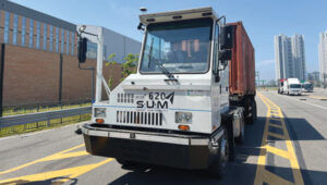
    In 2022, Septentrio and SUM partnered for the joint development and technical application of a multi-sensor fusion system for autonomous driving. This led to the integration of Septentrio’s AsteRx-SBi3 Pro+ into SUM SMOBI platform vehicles.

    Septentrio’s AsteRx-SBi3 Pro+ integrated into SUM’s autonomous vehicles.
    Septentrio’s AsteRx-SBi3 Pro+ integrated into SUM’s autonomous vehicles.

    The AsteRx-SBi3 Pro+ features Septentrio’s FUSE+ inertial sensor-fusion technology, which offers a comprehensive solution for these challenges. This includes centimeter-level positioning accuracy (horizontal: 0.6 cm + 0.5 ppm, vertical: 1 cm + 1 ppm) and integrated attitude accuracy (heading: 0.15°, pitch, and roll: 0.02° using a dual antenna set-up) to maintain precise vehicle operation. Additionally, the INS provides reliable speed data (0.02 m/s) for smooth and stable motion control.

    In Gangneung, South Korea, a shuttle drives fully autonomously on the city’s roads. While a human driver is still required by law as a safety precaution, this is the first step to a more autonomous transport future.

    SUM is collaborating with local governments to allocate bus routes for autonomous vehicles. The company operates autonomous buses on routes in Seoul, South Korea, including the Sangam Dong A2 autonomous vehicle for the Cheongwadae shuttle bus and late-night bus services. SUM also operates autonomous vehicles in Gangneung City.

    According to members of the SUM team, this technology ensures accurate stops, optimal route planning, and improved passenger safety by minimizing the risk of collisions and ensuring timely arrivals. SUM’s autonomous shuttles and on-demand transit services benefit from precise positioning, allowing them to adjust routes dynamically based on real-time passenger requests and traffic conditions.

    The benefits

    According to SUM, coupling Septentrio’s AsteRx SBi3 Pro with SUM’s software and hardware solutions has unlocked many benefits, including:

    • Enhanced safety: Precise positioning and reliable navigation are paramount for the safety of all autonomous vehicles. Septentrio’s technology ensures accurate lane positioning and collision avoidance capabilities, safeguarding people and property across multiple sectors.
    • Greater reliability: Septentrio’s antennas ensure consistent and reliable performance for autonomous vehicles, even in challenging conditions. This minimizes downtime and disruptions.
    • Sustainable transportation: Autonomous vehicles can potentially reduce traffic congestion and emissions across the board. SUM’s technology, which is integrated into various autonomous vehicles, contributes to a more sustainable transportation future for cities and industries.

    Additional application: Autonomous port operations

    In ports around the world, many aging yard trucks are still being used. However, the industry has been gradually adopting automated port operations to move away from outdated positioning methods and toward autonomous solutions that can redefine operational standards.

    Early attempts at using GNSS for positioning autonomous machines in ports faced significant challenges. The chaotic environment of large moving metal machines and constantly changing container stacks created blockage and multipath position errors, making it hard to achieve reliable centimeter-level GNSS positioning.

    SUM’s yard tractors utilizing Septentrio’s products.
    SUM’s yard tractors utilizing Septentrio’s products.

    Modern GNSS technology has revolutionized port automation with its ability to achieve centimeter-level accuracy for autonomous trucks, forklifts and container carriers to navigate narrow lanes and confined spaces with unprecedented precision, dramatically reducing collision risks. Often, autonomous port vehicles must maneuver between cranes with minimal room for errors, highlighting the importance of reliable high-precision technology in the field. This level of precision and adaptability is vital in the logistics industry, given that 90 percent of the world’s goods are transported by sea and 60 percent are packed in large steel containers.

    At the Port of Incheon in South Korea, which is on the Yellow Sea across from Northern China, SUM is conducting proof of concept (POC) trials of its autonomous vehicles using Septentrio’s AsteRx-SBi3 Pro+ rugged GNSS/INS receiver. The autonomous yard trucks at Incheon Port successfully navigate autonomously between point A and point B, with the SUM team nearby to identify and resolve any issues. The SUM team said they are focused on stabilizing the system to achieve a fully unmanned operation, aiming to enhance efficiency and automation in port logistics.

    SUM notes that integrating Septentrio’s technology with autonomous vehicles in smart ports simplifies operations by providing accurate positioning, enhancing safety and optimizing routes, as well as improving overall port efficiency. The integration supports the seamless operation of autonomous vehicles, helping ports manage their logistics more effectively and respond to the dynamic demands of modern cargo handling.

    The autonomous port trucks also are being tested with the new AntaRx-Si3 and AntaRx-AUX antennas installed simultaneously. High update rate logging can improve CPU load and how the antenna’s robust real-time kinematic (RTK) engine uses fewer satellites to reduce the CPU load.

    Overcoming positioning obstacles

    SUM’s advanced online localization system is designed to continuously track the position of its autonomous vehicles, even in GNSS-compromised environments.

    “Our system leverages a sophisticated sensor fusion algorithm that primarily relies on high-accuracy GNSS/INS information from the Septentrio module,” said Daehyuck Park, Ph.D., managing director at SUM. “This module serves as the core source of our positioning data.”

    To improve the robustness of the localization system, the company integrated additional sensors, including lidar and cameras. These sensors provide odometry data and facilitate map-matching using static landmarks in pre-mapped areas. By combining data from these sources, SUM explains that its system can perform reliable dead reckoning and offers precise map-based pose corrections to maintain high performance across various challenging environments.

    One key challenge in this approach is the potential for GNSS blockages. To address this, SUM has incorporated dead reckoning technology into its systems, which augments the GNSS/INS module’s positioning capabilities by delivering continuous position estimates even when GNSS signals are unavailable.

    Integrating vehicle localization systems further enhances dead reckoning by counteracting drift caused by biases in IMU measurements.

    Additional sensors such as lidar can improve dead reckoning accuracy further, particularly during movements involving high wheel slips, which dilute the precision of wheel odometry. Despite these advancements, relying solely on dead reckoning for extended distances can lead to an unbounded accumulation of positioning errors.

    According to the SUM team, Septentrio’s AsteRx SBi3 Pro+, coupled with SUM’s software and hardware solutions, has unlocked many benefits. Other urban use cases include enhancing delivery services by effectively managing routes and improving traffic management through fleet coordination. SUM adds that autonomous vehicles have the potential to reduce traffic congestion and emissions across the board. SUM’s technology, integrated with a variety of autonomous vehicle applications, contributes to a more sustainable future for our cities and industries.

    SUM is continuing to focus on developing solutions to ensure accurate positioning and reliable autonomous operations in challenging environments. SUM and Septentrio aim to accelerate the integration of autonomous solutions to streamline port operations and autonomous vehicle applications in urban environments. The partnership is driving progress toward a more autonomous future, with the goals of reducing costs, increasing efficiency and adapting to the challenges posed by congested GNSS environments. Their joint efforts are being rigorously tested for accurate positioning throughout an autonomous vehicle’s entire journey, even in areas where GNSS signals may be compromised.


    On the cover

    Saronic vessels equipped with advanced sensors in contested waters. (Photo: Septentrio / Saronic)
    Saronic vessels equipped with advanced sensors in contested waters. (Photo: Septentrio / Saronic)

    Anti-jamming and anti-spoofing technology protects receivers

    Saronic, a Texas-based defense technology company, is leveraging the latest cutting-edge technology for their autonomous surface vessels (ASVs) designed for critical naval missions. These vessels are equipped with sensors for enhanced domain awareness in contested waters. They are designed for tactical deployment, alone or in collaborative swarms, via at-sea launch and recovery from expeditionary craft. Saronic selected Septentrio’s GNSS inertial navigation system (INS)  receivers for resilient positioning and orientation for navigating in the most challenging environments. Advanced interference mitigation (AIM+) technology protects Septentrio receivers from jamming and spoofing attacks that threaten to disrupt GNSS-based navigation.

  • Research roundup: Enhancing GNSS resilience

    Research roundup: Enhancing GNSS resilience

    GNSS researchers presented hundreds of papers at the 2023 Institute of Navigation (ION) GNSS+ conference, which took place Sept. 11-15, 2023, in Denver, Colo., and virtually.

    The following four papers focused on ways to combat GNSS jamming and spoofing. The papers are available here.

    GPS World will attend this year’s ION conference in Baltimore, Maryland on Sept. 16-20.


    Approximating Regional GNSS Interference Sources Using ADS-B Data

    Photo: zhanghaitao / iStock / Getty Images Plus / Getty Images
    Photo: zhanghaitao / iStock / Getty Images Plus / Getty Images

    The Automatic Dependent Surveillance-Broadcast (ADS-B) system, widely used for air traffic operations and management, also has potential applications in identifying, detecting and localizing (IDL) GNSS/RFI jamming sources in regions with high air traffic. With the rise in global GNSS interference reports, it is crucial to identify and eliminate jammers to ensure safe air travel operations.

    The Navigational Integrity Category (NIC) value included in the ADS-B message is a key indicator for detecting potential jamming from ADS-B data. Although NIC is not the most effective metric for interference detection, it can still signal the presence of jamming and offer a means to localize the source in real time.

    This research aims to approximate the area of GNSS/RFI interference by fitting a Euclidean Cone to ADS-B data that reports low NIC values. The problem is formulated as a convex optimization problem, derived from an alternative version of the maximum inscribed ellipsoid approach. By fitting an optimal cone to the data affected by interference, the cone’s apex indicates the estimated jamming location. The research team processed, decoded, interpolated and filtered ADS-B data to enhance localization accuracy.

    The proposed convex formulation was tested on two reported interference events: one near Denver International Airport in January 2022, for 36 hours, and another near the Dallas-Fort Worth area in October 2022, over roughly eight hours. In Denver, four estimated jamming locations, calculated from four six-hour time windows, were grouped between downtown Denver and the airport. In Dallas, three estimated jamming locations, determined from three one-hour windows, showed a tighter grouping on the southern side of the Dallas/Fort Worth area, indicating spoofing was nearby.

    Michael Dacus, Zixi Liu, Sherman Lo and Todd Walter, “Approximating Regional GNSS Interference Sources as a Convex Optimization Problem Using ADS-B Data.”

    Hybrid Autoencoder for Interference Detection

    Malfunctions or failures in GNSS services can result in significant personal, material, and financial damages. Early identification of anomalous behavior in GNSS signals can enable timely countermeasures. However, many interference monitoring or mitigation techniques are only feasible with high-end receivers and demand a certain level of expertise to be used effectively.

    This paper presents a GNSS interference monitoring approach employing machine learning methodologies for users of any expertise level and with any type of GNSS receiver capable of outputting raw GNSS observations. The research team used simple signal-to-noise ratio (SNR) observations and different hybrid autoencoder models, including denoising or variational autoencoder combined with recurrent neural network (RNN) models, which are trained and tested on real jamming and spoofing events. The developed monitoring system is represented by a “traffic lights” system, indicating the severity or level of concern associated with each detected anomaly.

    The results compare different RNN-based autoencoder implementations and have been tested on input data from high-end to low-end GNSS receivers. The analysis of the test set showed that there is a 95 percent probability of catching anomalies. Additionally, similar results were achieved when applied to other geodetic receiver types such as u-blox or JAVAD GNSS receivers. However, smartphone data is subject to some limitations. Notably, missed anomalies are primarily attributed to the low transmitting power from the jamming and spoofing devices, which poses challenges for detection.

    Karin Mascher, Stefan Laller and Philipp Berglez, “Hybrid Autoencoder for Interference Detection in Raw GNSS Observations.”

    A Tool to Monitor, Analyze and Record Navigation Signals

    Given the heavy reliance on GNSS for numerous critical applications, any disruption caused by intentional or unintentional RFI could pose significant threats to operations that depend on these systems, from transportation and logistics to emergency services and national security. Developing advanced countermeasures against RFI has become a priority to ensure the functionality and resilience of GNSS-dependent systems.

    This paper presents an architecture for real-time detection and classification of RFI affecting multi-band GNSS signals based on a machine learning method. The study proposes an architecture combining an actual GNSS monitoring station for recording GNSS signals — a Navigation Signals Monitoring, Analysis, and Recording Tool (N-SMART) system — with a deep neural network approach to detect and classify different classes of interferences.

    Researchers propose a novel architecture for real-time interference detection and classification of RFI, which can continuously monitor and record multi-band GNSS signals and provide timely warnings in case of RFI. The proposed architecture utilizes the N-SMART system to capture and store the GNSS signals, while detection and classification are implemented using a deep neural network technique. The core principle of the suggested method is to implement a convolutional neural network (CNN) classifier inside a Docker container, running on top of the N-SMART system.

    The results of the experimental test campaign on real interfered GNSS signals showed an overall accuracy of 85 percent, demonstrating the potential for effective, real-time classification of RFIs in GNSS. The research team explains that future work could focus on optimizing the model or exploring new architectures of CNN to improve accuracy and reduce task completion time across a variety of applications.

    Iman Ebrahimi Mehr, Alex Minetto and Fabio Dovis, “A Navigation Signals Monitoring, Analysis and Recording Tool: Application to Real-Time Interference Detection and Classification.”

    GNSS RFI Mitigation in Commercial Airborne Receivers

    Reports from air navigation service providers worldwide indicate that commercial airborne GNSS receivers are increasingly being subjected to jamming and spoofing attacks. Consequently, there is a growing need to ensure that the raw GNSS measurements provided to aircraft systems are not compromised by spoofing. Validating these measurements is critical to maintaining the integrity and reliability of navigation systems used in aviation.

    This paper focuses on two techniques under development by Collins Aerospace to be incorporated via a field-loadable software update to the Collins GLU-2100 multi-mode receiver to combat spoofing attacks. The first method, Receiver Autonomous Signal Authentication (RASA), uses the known characteristics of the GNSS receiver oscillator to detect whether the received signals are from a spoofer.

    A second technique, Staggered Examination of Non-Trusted Receiver Information (SENTRI), uses the inertial sensor data already available from the aircraft’s IRS/INS, to monitor the coherence between pure GNSS, pure inertial (INS) navigation solutions or tightly coupled inertial GNSS hybrid solutions without augmentation. SENTRI further allows the computation of position integrity levels (HPL and VPL) in the presence of GNSS spoofers. The paper will describe the overall RFI mitigation architecture that is implemented on the GLU-2100.

    RASA and SENTRI can be used together in a complementary fashion to detect the presence of spoofers reliably. It will also provide improved robustness to data spoofing attacks that induce errors in ephemeris, almanacs, GPS time jumps, etc., and will enable the GLU-2100 to coast through GNSS outages that are induced due to spoofing or jamming.

    Future technologies will use antenna techniques, signal analysis, DFMC signals and APNT to increase the robustness to new and evolving threats. The goal of this RFI mitigation roadmap is to continue to ensure that GNSS can be used safely and reliably in civil aviation.

    Angelo Joseph, Joseph Griggs, Patrick Bartolone, Bernard Schnaufer, Huan Phan, Vikram Malhotra, “GNSS Radio Frequency Interference Mitigation in Collins Commercial Airborne Receivers.”

  • 3D scanning uncovers mysteries in historic church murals

    3D scanning uncovers mysteries in historic church murals


    Towering at 25 m, the barrel vault of the Grote Kerk in Naarden showcases an extraordinary work of art. The five-century-old paintings above the nave and choir are astonishingly well-preserved, with every panel remaining intact. (Photo: Stichting Grote Kerk Naarden)
    Towering at 25 m, the barrel vault of the Grote Kerk in Naarden showcases an extraordinary work of art. The five-century-old paintings above the nave and choir are astonishingly well-preserved, with every panel remaining intact. (Photo: Stichting Grote Kerk Naarden)

    The Grote Kerk in Naarden, Netherlands, often called the “Sistine Chapel of the North,” is undergoing a 3D scanning project to uncover the secrets of its medieval ceiling murals. The digital research initiative aims to illuminate the long-standing mysteries surrounding the artwork’s origins, including the artists’ identities and the precise timeframe of their creation.

    Researchers from various Dutch universities are collaborating to create a detailed digital 3D model of the church’s barrel vault. Using 3D scanning technology, the team produces high-resolution digital mural replicas. These scans will enable researchers to examine the artwork more precisely, revealing intricate details in brushwork and pigmentation that are invisible to the naked eye. This in-depth analysis could potentially lead to the identification of the artists and provide new insights into the techniques and materials they used.

    This project serves a dual purpose: uncovering historical information and preserving cultural heritage. The digital models will act as a permanent record of the artwork, ensuring its preservation for future generations and increasing accessibility through online platforms.

    Student involvement and restoration planning

     Before the commencement of large-scale restoration efforts, students can explore and work within the church. The technology allows for comprehensive documentation of the expansive painted surfaces. Additionally, students are tasked with developing strategies to support the restoration process, such as creating digital models to test potential interventions without risking damage to the actual vault.

    The project covers 700 square meters of painted planks and beams. Following the completion of the research and scanning phases, the restoration process is expected to take two and a half years and require an investment exceeding $2 million.

    As this project progresses, researchers are optimistic that their work will unveil new aspects of Grote Kerk’s artistic legacy, providing a more profound understanding of this significant piece of Dutch cultural heritage.

  • Seen & Heard: UAVs advance medicine delivery, increases in GPS jamming and more

    Seen & Heard: UAVs advance medicine delivery, increases in GPS jamming and more

    “Seen & Heard” is a monthly feature of GPS World magazine, traveling the world to capture interesting and unusual news stories involving the GNSS/PNT industry.


    Tracking down criminals

    Photo: m-gucci / iStock / Getty Images Plus / Getty Images
    Photo: m-gucci / iStock / Getty Images Plus / Getty Images

    In Deschutes County, Oregon, a sheriff’s deputy used a GPS-based tracker to tag a stolen pickup truck, leading to the arrest of a suspect who tried to evade a traffic stop. After a short pursuit, the deputy tagged the vehicle using a StarChase device, which can fire a GPS-based tracking device from a law enforcement vehicle to attach to a suspect’s vehicle. The truck was tracked, and the suspect was apprehended.

    UAVs advance medicine delivery

    Photo: Oundum / iStock / Getty Images Plus / Getty Images
    Photo: Oundum / iStock / Getty Images Plus / Getty Images

    Wing and Apian have partnered with Blackrock Health and St. Vincent’s Private Hospital in Dublin, Ireland, along with healthcare technology company Medtronic, to launch a UAV delivery trial for medical supplies and devices. The delivery service will include Medtronic’s ingestible camera, PillCam, sutures, surgical tools and heart valve repair products, with plans to expand to pacemakers and implantable cardiac defibrillators (ICDs) in the future. Wing’s UAVs are designed for quicker and more reliable deliveries than traditional transport methods, avoiding traffic congestion in Dublin.

    Finland faces increase in GPS jamming

    Finnish authorities have reported a surge of GPS malfunctions in the area. Authorities speculate the disturbances are due to Russian jamming. The reports were brought to the public’s attention when a Finnish maritime pilot shared on social media a video depicting radar malfunctions. Traficom, Finland’s federal transport and communications agency, told local news outlet Iltalehti that there has been a noticeable increase in GPS malfunctions, although it detected no interference with radar frequencies in the Gulf of Finland.

    China takes PNT to the moon

    Photo: Elen11 / iStock / Getty Images Plus / Getty Images
    Photo: Elen11 / iStock / Getty Images Plus / Getty Images

    Scientists from the Beijing Institute of Spacecraft System Engineering proposed the construction of 21 positioning, navigation and timing (PNT) satellites around the moon to support China’s lunar ambitions. The satellites will be deployed in four types of orbits over three phases, featuring a sustainable and cost-effective design, according to a paper published in the Chinese Space Science and Technology journal. China aims to put astronauts on the moon by 2030 and build a research base at the lunar south pole with international partners around 2035, according to the paper.

  • First Fix: Global Glitch

    First Fix: Global Glitch

    From Hong Kong to Berlin, from Sydney to New York, the operations of hospitals, airlines, banks, and scores of other businesses and services were disrupted on July 19 due to a glitch in a software update issued by the cybersecurity firm CrowdStrike that affected computers using the Microsoft Windows operating system.

    The New York Times described it as “a stunning example of the global economy’s fragile dependence on certain software, and the cascading effect it can have when things go wrong.”

    Regular readers of this magazine, and of this column in particular, will know where I am going with this: like Windows, GPS — and, more broadly, GNSS — presents a single point of failure for many systems. That is, if GPS fails, it will stop those entire systems from working.

    Possible challenges and threats to GPS use include space weather; interference/jamming and/or spoofing of receivers; error or failure of satellites, monitoring, or control; and, in the most extreme case, an attack on satellites, monitoring, or control.

    The National Space-Based PNT Advisory Board continues to focus its efforts on its excellent PTA strategy: to protect (“prevent or remove conditions that degrade, distort, or deny GPS use”), toughen (“make GPS use more robust against challenges and threats”), and augment (“provision of GPS enhancements as well as provision and use of alternate [PNT] sources that complement, back up, or replace (partly or entirely) use of GPS”) civil uses of GPS. More on that soon.

    Meanwhile, others are urging we think of GNSS as only one of several complementary means to achieve the mission of positioning, navigation and timing (PNT) with accuracy, availability, integrity, continuity and coverage. For that perspective, see Mitch Narins’ piece. He writes that we should focus “on services that are not space-based, operate in different areas of the spectrum, are capable of higher power, and can be installed and evolved more quickly to mitigate emerging threats.”

    The European Space Agency’s recent PNT Vision 2035 paper, written by a panel of independent external PNT experts to advise next year’s ESA Ministerial Conference, summarizes European discussions on PNT in the past several years. In the words of Luis Mayo, the chair of the advisory committee that wrote the report, “there is more to PNT than satellite navigation.” While we must “sustain the existing satellite-based navigation systems,” he argues, we should also promote “the development of alternative independent PNT systems.” Read a short interview with Mayo by Dana Goward, starting on page 19.

    Yet other efforts integrate GNSS with different, independent techniques to create new synergies. One example is ESA’s Genesis multi-modal space mission, which aims to improve geodetic applications by collocating on board a single well-calibrated satellite the four space-based geodetic techniques: GNSS, very long baseline interferometry (VLBI), satellite laser ranging (SLR) and Doppler Orbitography and Radio-positioning Integrated by Satellite (DORIS).

    “This first-time collocation in space will establish precise and stable ties among these key techniques,” write the authors of this quarter’s “Innovation” column.

  • If not GNSS, then what?

    If not GNSS, then what?

    Photo:
    Image: 3DSculptor/iStock / Getty Images Plus/Getty Images

    If not GNSS, then what? That is an interesting question.

    To some, it means GNSS is so important and unique that without it, all is lost. They enthusiastically support only GNSS-centric research and development, believing that any issues that GNSS has today — such as lack of resilience — can be resolved given enough time and money. It includes pushing for the discontinuance of ground-based systems and the “re-purposing” of their resources to produce more satellites and more space-based signals. It demonstrates an admirable and true dedication to the belief that GNSS is the mission.

    To others, these words have a different and darker meaning, warning of a clear and present danger. To them, it means “When (not if) GNSS is not available, what other source(s) of positioning, navigation and timing services (PNT) will be available to support GNSS users’ missions and goals?” For these purpose-driven individuals, GNSS is a means — not the mission, which is to provide the necessary positioning, navigation and/or timing performance, such as accuracy, availability, integrity, continuity and coverage, required to ensure the nation’s safety, security and economic well-being.

    Unfortunately, some who have made GNSS their mission strive to convince others that it should be their mission, too!

    GNSS is magic — but only when it works. It has played and will continue to play a crucial part in advancing our knowledge and abilities and supporting diverse use cases worldwide. It should and must be supported, but not to the exclusion of everything else. Recently, the magic has failed numerous times all around the world and, as a PNT community of suppliers and users, we must know we are capable of so much more.

    We also know that the vast majority of civil PNT service needs are local, not global — based in part on the population density of users and their use cases. Over the years, GNSS’ accuracy and coverage have spoiled us. We even chose to see GNSS interference events as proverbial “black swans.” At the same time, the abandoning of well-engineered, resilient local solutions in favor of a global, one-size-fits-all mentality has been appealing to many. We know this approach is fraught with danger. Throwing away perfectly acceptable, resilient local means rather than enhancing them and bringing their technology into the 21st century may, as a PNT community, be our biggest regret. In many ways we have already gone too far.

    I encourage our PNT community to commit to doing more, to open up our minds to design, develop, evolve, create, install, implement and operate more resilient PNT sources and more resilient user systems for which PNT services are critical inputs — especially by focusing on services that are not space-based, operate in different areas of the spectrum, are capable of higher power, and can be installed and evolved more quickly to mitigate emerging new threats. Most importantly, we all need to accept and support the true mission of our PNT community, the “why” that drives our innovative solutions: to ensure PNT services always will be available to support our safety, security and economic well-being.

  • Innovation Insights: A history of techniques and services that contributed to the refinement of the ITRF

    Innovation Insights: A history of techniques and services that contributed to the refinement of the ITRF

    Click to read the full Innovation article, “ESA’s multi-modal space mission to improve geodetic applications


    Innovation Insights with Richard Langley
    Innovation Insights with Richard Langley

    IN THE BEGINNING of the space age, there was only one space-based positioning technique: satellite Doppler. Shortly after the launch of the first satellite, Sputnik 1, on Oct. 4, 1957, it was realized that by using a receiver to measure the Doppler frequency shift of a satellite’s transmitted signals combined with knowledge of the satellite’s orbit, the position of the receiver could be determined.

    The United States Navy used this concept to develop the Navy Navigation Satellite System, commonly known as Transit. Although its initial use was for positioning Polaris submarines, it was released for commercial use in July 1967. Transit was used worldwide for positioning and navigation until it was decommissioned at the end of 1996. We talked about Transit in the introduction to the article “Easy Peasy, Lemon Squeezy: Satellite Navigation Using Doppler and Partial Pseudorange Measurements” in this column’s October 2012 edition.

    Next on the scene was very long baseline interferometry (VLBI). This was, and still is, a technique for high-resolution mapping of galactic and extragalactic radio sources such as quasars. It was invented by Canadian and American radio astronomers with the Canadians getting the first interference “fringes” on a transcontinental baseline on May 21, 1967. VLBI uses radio telescopes, separated by 100s or 1,000s of kilometers, to record signals on storage media (previously magnetic tape and subsequently disk-based systems) synchronized by atomic clocks, typically hydrogen masers. The recordings are played back and cross-correlated at a central facility to produce the observation data – essentially the difference in arrival times of the radio signals at the radio telescopes. It was apparent that VLBI measurements could also be used to precisely determine the vector baselines between pairs of radio telescopes eventually down to a few millimeters, so VLBI became an important geodetic technique, even measuring the drift of the continents in essentially real time. We featured an article on VLBI in this column in February 1996, “The Synergy of VLBI and GPS.”

    Around the same time that VLBI was being developed, satellite laser ranging (SLR) made its debut. SLR works by precisely measuring the two-way travel time of laser pulses sent from telescopes on Earth to arrays of corner-cube reflectors on specially equipped satellites. The first experiments were conducted with Beacon Explorer A in 1964. Initial results had a range accuracy of about three meters. Since then, more than 100 satellites have been launched with SLR reflectors, including the GLONASS, Galileo, BeiDou and Quasi-Zenith navigation satellites, the Indian regional satellites and a couple of GPS satellites with more to come. Ranging precisions are now as good as a few millimeters. Laser ranging is also conducted using reflector arrays on the surface of the moon. Back in September 1994, we had an SLR article in this column, “Laser Ranging to GPS Satellites with Centimeter Accuracy.”

    Skipping over GNSS, with which most of us are very familiar, then came Doppler Orbitography and Radio Positioning Integrated by Satellite (DORIS). DORIS was developed in France by a group of institutions led by the Centre National d’Études Spatiales. Rather than transmitting signals from satellites and measuring the Doppler shift at receivers on the ground, the system transmits signals from a global network of ground-based beacons, which are picked up by receivers on specially equipped satellites and the data is subsequently downloaded to Earth. The first such equipped satellite was SPOT-2, launched in January 1990. Since then, 18 more satellites with DORIS receivers on board have been launched to date. DORIS, along with the other techniques, was discussed in the online GPS World article, “NASA Helps Maintain International Terrestrial Frame with GNSS,” published in February 2016.

    Like the global navigation satellite systems with the International GNSS Service, the other techniques have their coordinated services, too: the International VLBI Service for Geodesy and Astrometry (IVS), the International Laser Ranging Service (ILRS), and the International DORIS Service (IDS).

    All of these techniques and services contribute to the refinement of the International Terrestrial Reference Frame (ITRF), on which all positioning activities on Earth eventually depend. Tying the contributions from the different services together involves accounting for any systematic differences, which are reduced in part by using positional data at collocated sites where two or more techniques are sited with the vector ties between the instruments carefully measured. The September 1996 edition of “Innovation” was on the IERS and was aptly titled “International Terrestrial Reference Frame.”

    The ITRF will enter a new era with the European Space Agency’s Genesis mission. The mission’s satellite will carry instruments for all four space-geodetic techniques: GNSS, VLBI, SLR and DORIS. In this quarter’s “Innovation” column, a team of Genesis mission engineers and scientists introduce the mission, describe its components and outline its benefits. My well-thumbed copy of the Concise Oxford Dictionary of Current English has two definitions for the word “genesis.” The first, with a capital “G,” is the title of the first book of the Old Testament with its well-known first verse. The second is “Origin, mode of formation or generation” and comes from the Greek word genēs, meaning birth, born or produced. It is clearly a fitting name for ESA’s new mission.

  • Innovation: ESA’s multi-modal space mission to improve geodetic applications

    Innovation: ESA’s multi-modal space mission to improve geodetic applications

    Genesis satellite.
    Genesis satellite.

    The combination of advanced technologies for precise orbit determination and timing, as well as the scientific exploitation of GNSS signals, opens major new opportunities for relevant, innovative in-orbit scientific experiments. These opportunities come in the fields of Earth sciences, including geodesy, geophysics and GNSS remote sensing of the atmosphere, land, ocean and ice, fundamental physics, astronomy and time metrology. They could extend some current operational applications such as precise orbit determination for geodesy and altimetry and GNSS radio occultation for meteorology and space weather.

    To further enhance the benefits of combining space-based geodetic techniques, the European Space Agency (ESA) has established the Genesis mission. The mission will collocate on board a single well-calibrated satellite, the four space-based geodetic techniques: GNSS, very long baseline interferometry (VLBI), satellite laser ranging (SLR) and Doppler Orbitography and Radio-positioning Integrated by Satellite (DORIS). This first-time-ever collocation in space will establish precise and stable ties among these key techniques. The Genesis satellite will be a unique, dynamic space geodetic observatory, whose observations, combined with the measurements using geodetic collocation techniques stations on Earth, will contribute to a significant improvement of the International Terrestrial Reference Frame (ITRF).

    The ITRF is recognized as the foundation for all space- and ground-based observations in Earth science and navigation, and therefore this mission will potentially have a major impact on several GNSS and Earth observation applications. It is a particular realization of the terrestrial reference system, and its history goes back to 1984 when the former Bureau International de l’Heure, which was then in charge of maintaining an accessible reference frame, established a frame using space-based geodetic techniques. The tradition was continued by the International Earth Rotation and Reference Systems Service (IERS) when it was established in 1987. The IERS has periodically updated the ITRF incorporating new systems, data sets and analysis procedures. The Genesis mission will help identify any systematic errors in the ITRF and thereby improve the accuracy and stability of the frame, particularly the origin and scale of the frame, which are the most critical parameters for scientific applications.

    The Genesis mission was endorsed by the ESA Ministerial Council in November 2022. The mission will be executed under the responsibility of ESA’s Navigation Directorate as an element of the Future Navigation Program in cooperation with ESA’s Operations Directorate.

    ESA performed an internal mission feasibility study (a so-called concurrent design facility) in March and April 2022. A team of more than 40 experts reviewed the mission objectives and the possible implementation, derived high-level mission requirements, assessed the necessary mission instruments and their technology readiness level and concluded that the mission is feasible and compatible with the Genesis-defined program boundaries.

    GENESIS MISSION OBJECTIVES

    The overall mission goal, as defined by the Global Geodetic Observing System (GGOS) initiative of the International Association of Geodesy, is to help achieve an ITRF accuracy of 1 millimeter with long-term stability of 0.1 millimeters per year, to be able to detect the smallest variations in the Earth system solid, fluid and gaseous components.

    Figure 1: Genesis mission concept.
    Figure 1: Genesis mission concept.

    The improvements of the ITRF will impact and improve multiple geodetic and geophysical observables, as well as precise navigation and positioning, and strengthen the geodetic infrastructure, including the Galileo constellation, by reducing the systematic biases between different observing techniques.

    Furthermore, the Genesis mission will allow us to improve the link between the ITRF and the International Celestial Reference Frame (ICRF) due to improvement in determining the Earth orientation parameters (EOPs). The ICRF is a realization of a quasi-inertial reference system defined by extragalactic radio sources, mostly quasars, billions of light years away. The positions of a set of globally distributed VLBI radio telescopes are determined using the difference in the arrival times of the signals at the different telescopes. The ICRF was established and is maintained through a cooperation between the International Astronomical Union and the IERS.

    The ITRF and the ICRF are related through the EOPs, which include pole coordinates, the Earth’s rotation angle typically referred to as Universal Time (and the related length of day), and nutation angles and their rates.

    GENESIS MISSION OVERVIEW

    Figure 2 Genesis project organization.
    Figure 2 Genesis project organization.

    The baseline orbit of the Genesis satellite will be circular, will have an altitude of about 6,000 kilometers and an inclination of about 95 degrees. The mass of the satellite will be on the order of 250 kilograms to 300 kilogramsg, and it will have very precise on-board metrology, through a single ultra-stable oscillator. An artist’s conception of the satellite in space is shown in the opening image. The launch is foreseen for 2028, and the baseline duration for operations is two years with an option for extension.

    The Genesis mission architecture will consist of the Genesis satellite, a ground control segment constituted by a mission control center and a (network of) ground station(s), a data processing center (including a global GNSS sensor station network), a data archiving and distribution center, and the required ground infrastructure for the VLBI, SLR and DORIS campaigns (See FIGURE 1). The scope of the procurement for this mission is the Genesis satellite, the ground control segment, the launch service and two years of operations with the option for extension.

    As previously mentioned, the satellite will be launched as the first with all four space-based geodetic techniques on board — namely GNSS, VLBI, SLR and DORIS:

    • GNSS receiver. This will be a high-quality multi-constellation (Galileo and GPS) and multi-frequency space receiver. The GNSS observations will be of very high quality and will allow multi-GNSS integer ambiguity resolution for the carrier phase with a very high success rate. This instrument is crucial for the very precise orbit determination of the Genesis satellite.
    • VLBI. This instrument will transmit radio signals compatible with receivers at each observing VLBI station. To eliminate the ionospheric dispersive delay along the paths to each station, different frequency bands will be used. The signals will also comply with the evolving observation procedures at all VLBI stations. The signals will be observed by all geodetic VLBI antennas, including the new VLBI Global Observing System (VGOS) fast slewing stations, in their standard geodetic receiver setups. The transmitter currently under development is designed to transmit at different frequencies between 2 GHz and 14 GHz, but also higher frequency bands can be considered. The present setup for regular VGOS observations use four 1-GHz-wide bands within the S, C and X frequency bands. The unit is designed to transmit both pseudo-noise and random noise. The random noise signal mimics the broader-band noise emitted by quasar radio sources routinely observed by VLBI, and hence can be processed essentially by the usual station and correlator software. VLBI observations of Genesis will enable VLBI stations to be accurately located within the ITRF consistently with the other geodetic techniques, enable a frame tie between the celestial frame and the dynamic reference frames of satellite orbits as well as a frame tie between the ITRF and the extremely accurate and stable ICRF.
    • SLR. A passive SLR retro-reflector (LRR) will be attached to the satellite in such a way to ensure an adequate field of view when the satellite is in Earth-pointing mode. The SLR observable is the round-trip time of flight of a laser pulse between a ground station and the LLR. Currently, the ITRF long-term origin is defined by SLR, and this is the most accurate satellite technique in sensing the Earth’s center of mass.
    • DORIS. Genesis will include a DORIS receiver instrument. DORIS is based on the principle of the Doppler effect between a network of transmitting terrestrial beacons and the on-board instrument. DORIS was first featured on the SPOT-2 satellite launched in 1990. Since then, DORIS receivers have been featured on multiple satellites. The integration of the DORIS receiver on Genesis, given the high-precision knowledge of the Genesis orbit, will benefit other space geodetic techniques from the global DORIS network distribution.

    All active instruments will rely on a single high-precision compact frequency standard payload, termed the ultra-stable oscillator.

    GENESIS PROJECT ORGANIZATION

    The Genesis mission is being procured in an end-to-end approach, meaning that the industry prime is responsible for the development of the satellite, including the payload instruments, the launch services and the satellite operations. For this reason, the following approach has been applied: contract signature was in March 2024. Design, development, validation and acceptance will take place between 2024 and 2027, leading up to a planned launch in 2028.

    The contract for Genesis amounts to € 76.6 million. A consortium of 14 entities led by OHB Italia S.p.A. has been tasked with developing, manufacturing, qualifying, calibrating, launching and operating the Genesis satellite, including all its payloads. The mission is supported by Italy, Belgium, France, Switzerland, Hungary and the United Kingdom.

    Figure 3 Processing, archiving and distribution of Genesis data and products.
    Figure 3 Processing, archiving and distribution of Genesis data and products.

    The overall project organization is outlined in FIGURE 2. The ESA Genesis project team, led by the project manager, will manage and coordinate the work of all interfaces among i) the industrial consortium, ii) ESA in its role of handling data processing, archiving and operating the distribution center, iii) the scientific community for whatever the necessary interface is required for the preparation of scientific exploitation and coherency between the project development and the scientific mission objectives.

    For the data processing, exploitation, archiving and dissemination of data to the scientific community, the PROcessing, Archiving, exploitation and Dissemination Centre (PROAD) has been set up, (See FIGURE 3), using the European Space Operations Centre (ESOC) Navigation Support Office facilities and the GNSS Science Support Centre (GSSC) of the European Space Astronomy Centre (ESAC).

    For the data processing required in advance of scientific exploitation of the data, the ESOC Navigation Support Office facilities will be used. The data processing includes the precise orbit determination for the GENESIS satellite.

    Figure 4 Genesis science team.
    Figure 4 Genesis science team.

    Furthermore, after the processing performed by ESOC, ESAC’s GSSC will be used for data archiving and data distribution for scientific exploitation. The PROAD will be set up and coordinated internally in ESA.

    The setup and coordination of the required ground infrastructure, VLBI and SLR campaigns, the DORIS network and so on, will be managed by ESA’s Genesis project team together with a Genesis science team (See FIGURE 4).

    The science team will also support ESA’s Genesis project team as required in the reviews and follow-up activities, especially with respect to compliance with the mission objectives.

    SUMMARY

    The Genesis mission is a very challenging one, which has been made possible by the combined effort from the scientific community, ESA member states, industry and ESA itself. The success of Genesis will strongly depend on the interaction, cooperation and support of the international scientific community. The mission objectives of Genesis address core scientific as well as societal aspects. Above all, the Genesis mission is at the foundation level of all positioning and navigation.

    ACKNOWLEDGEMENTS

    This article has drawn, in part, on the multi-author paper “GENESIS: co-location of geodetic techniques in space,” Earth, Planets and Space (2023), Vol. 75, No. 5, https://doi.org/10.1186/s40623-022-01752-w

  • PNT Vision 2035 – A must read

    PNT Vision 2035 – A must read

    In June, the Navigation Innovation and Support Program (NAVISP) Advisory Committee (NAVAC) of the European Space Agency (ESA) issued a paper titled PNT Vision 2035. It provides an interesting overview of the state of positioning, navigation and timing (PNT) and where it will be a decade from now.

    According to ESA’s website, key findings in the paper include:

    • Increasing Dependence on PNT Services – particularly for consumer and autonomous solutions. Accurate timing remains a critical use case, especially in telecom and power distribution.
    • Geopolitical and Technological Challenges: Rising cyber-attacks, jamming and spoofing, advancements in AI, ML and quantum computing will have significant impacts. Anticipate new regulations.
    • Technological Trends Driving PNT Demand: The proliferation of connected devices (IoT), autonomous driving, advanced air mobility, smart grids and autonomous vehicles will drive the demand for resilient and robust PNT.
    • System Architecture Evolution: Future PNT systems will utilize a combination of data sources, including multiple GNSS constellations, cellular networks (5G/6G), terrestrial systems, augmentation systems, and autonomous sensors. This “system of systems” approach will enhance performance and ensure independence from single points of failure.
    • Emerging Technologies and Sensor Integration: Advances in space segment technologies, receiver designs and sensor integration, new signal designs, flexible payloads, advanced clocks, inter-satellite links, and higher power amplifiers are highlighted.
    Luis Mayo
    Luis Mayo

    We spoke with Luis Mayo, NAVAC’s chair, to get his take on this seminal work.

    Question: To set the stage, what is NAVAC?

    Luis Mayo: NAVAC is a group of external PNT experts that ESA has assembled to provide independent advice on navigation issues, and especially for NAVISP.

    Q: Where can NAVAC’s formal recommendations be found?

    Mayo: We perform an assessment of the NAVISP status every two years. We provide our recommendations as a conclusion of this assessment. Beyond that, our formal recommendations are collected in documents like this white paper or in proposals for modifications or adjustments to the work plans of the programs.

    Q: How does ESA leadership generally view and react to NAVAC conclusions and recommendations? Does it act upon every recommendation?

    Mayo: They are generally receptive. However, we are just an advisory body, so it is up to them to take on our recommendations. They often do so and use our advice to add weight to their proposal to the Navigation Programme Board, but they do not necessarily have to.

    Q: PNT Vision 2035 is a substantial document. Clearly it involved some time and effort. Why was it written? Is it something ESA requested?

    Mayo: The paper was the initiative of NAVAC members to inform the ESA Ministerial Conference in 2025. These conferences take place every three years to define the roadmap for the next period. New European space programmes, extensions or redirections of existing ones, and budgets are approved at these meetings.

    Q: We thought we might make a modest contribution to the definition of the future ESA navigation programmes. What, if anything, did NAVAC find surprising or unexpected about findings included in the Vision?

    Mayo: I would say that we hardly found anything too unexpected or surprising. The findings are the conclusion of multiple discussions on the subject over the past few years. We have just expressed them in a more articulated way.

    If anything, and from my personal perspective, I would like to highlight that this exercise helped me realize that the deployment of some of the most exciting or expected applications of PNT technologies — such as autonomous driving — depend on the development and deployment of multiple other technologies that might not be necessarily available in the mid-term.

    AVAC’s first meeting in 2018. From left to right: Javier Benedicto, ESA Navigation Director, and NAVAC members Alessandra Fiumara, Peter Grognard, Giorgio Solari, Rafael Lucas Rodriguez, Pierluigi Mancini, Roger McKinlay, Stefano Debei, Nityaporn Sirikan, Bernd Eissfeller and Luis Mayo.
    AVAC’s first meeting in 2018. From left to right: Javier Benedicto, ESA Navigation Director, and NAVAC members Alessandra Fiumara, Peter Grognard, Giorgio Solari, Rafael Lucas Rodriguez, Pierluigi Mancini, Roger McKinlay, Stefano Debei, Nityaporn Sirikan, Bernd Eissfeller and Luis Mayo. (Photo: ESA)

    Q: What are the three most important things policymakers should understand from the document?

    Mayo: First is that many infrastructures or services critical to the daily lives of the citizens are dependent on PNT technology.

    Second, they cannot take for granted that GPS or Galileo services will be always available, not to mention GLONASS or BeiDou. Satellite navigation systems are vulnerable and are continuously under threat. Enabling assured PNT service is a must.

    And third, there is more to PNT than satellite navigation. Other complementary or alternative technologies should not be abandoned. In fact, some of those technologies might even change the way in which we have traditionally conceived satellite-based navigation.

    Q: What are the most important things policymakers should do to enable the PNT needed by 2035?

    Mayo: I think they have to sustain the existing satellite-based navigation systems and foster the development of new technologies and systems that improve the robustness of the services. We have done a lot so far to provide PNT services globally. When you come to think of that, it’s really wonderful what we have achieved this far. We cannot afford to lose what we have, but that has proven not to be enough. Therefore, policymakers should keep helping the development of new technologies and services that complement what we have, improve the quality of the services and ensure its continuous availability and integrity.

    They should also look beyond the current service volume. Spacefaring nations should be aware of the fact that they will need this kind of technology to support future missions. Deploying systems able to provide PNT services beyond the coverage of the current GNSS is an absolute necessity to support such missions.

    Q: The vision says the EU must consider no longer having access to GLONASS and BeiDou. There are a number of threats that are common to all GNSS. Why not consider loss of access to all either temporarily or permanently?

    Mayo: We have not considered a completely catastrophic situation such as losing access to all GNSS in our vision. We understand that GPS, Galileo and eventually other constellations or augmentation systems will remain available and provide at least partial coverage for PNT services.

    Q: The vision makes recommendations about mitigating interference, using AI and extending the GNSS service volume. What else should policy and technology decision-makers take from the document and act upon?

    Mayo: We must not forget there is a clear case for investing in future PNT systems. ESA should keep up to pace with foreign competitors that seem ready to increase their expenditure in these types of problems.

    They also have to be conscious that satellite-based navigation is not enough. We have to look for alternative and complementary systems to reach the level of confidence that we need on PNT solutions.

    Q: Perhaps you are thinking of all the PNT systems China has deployed?

    Mayo: I am really thinking about what we are not doing in Europe or in the United States. We need to build alternatives that might not have global coverage but would allow us to maintain essential PNT services running at home.

    Q: Resilience seems to be an important theme in the document, but it was not the subject of a specific recommendation. Could you speak to that?

    Mayo: Resilience is a pervasive theme throughout the whole document. This is a major concern. We have to find a way to build a system of systems that can deliver to the user a trustworthy PNT solution at any time.

    Resilience is, today, a key consideration in PNT, and we cannot do anything but acknowledge this fact. We might not have insisted enough on the importance of this feature for future PNT systems, but policymakers must undertake any actions required to improve the resilience of the existing PNT systems and services, probably by promoting the development of alternative independent PNT systems.

    Q: What else should GPS World readers know about the Vision?

    Mayo: Read the document. It is not that long. Also, think that it has been written from an independent and experienced standpoint. We at NAVAC do not pretend to hold the full truth, but I believe that we have a quite comprehensive view of the matter and that this would be useful for the reader.

  • FAA makes history, approves BVLOS deliveries in Dallas

    FAA makes history, approves BVLOS deliveries in Dallas

    Photo: Zipline
    Photo: Zipline

    The Federal Aviation Administration (FAA) has authorized commercial UAV flights without visual observers in the Dallas-Fort Worth area, marking a significant milestone in U.S. aviation. This authorization has been granted to Zipline International and Wing Aviation, enabling them to conduct package delivery operations using UAVs while sharing airspace with conventional aircraft.

    The UAVs remain separated from manned aircraft using unmanned aircraft system traffic management (UTM) technology, with rigorous FAA safety oversight. UTM services allow companies to share data and planned flight routes with other authorized airspace users, offering safe organization and management of UAV flights in shared airspace. All flights occur below 400 ft altitude and away from any crewed aircraft. The FAA expects initial flights using UTM services to begin in August 2024.

    Typically, UAV operators must maintain visual line of sight with their aircraft. However, advancements in air traffic technology are paving the way for routine beyond visual line of sight (BVLOS) flights. This authorization is the first time the FAA has recognized a third party to safely manage drone-to-drone interactions, a significant step towards integrating UAVs into the National Airspace System.

    The FAA is working on the Normalizing UAV BVLOS Notice of Proposed Rulemaking (NPRM), which aims to enable UAV operators to expand operations while maintaining high safety standards. The NPRM is expected to be released this year, following strong Congressional support in the recent FAA reauthorization.

  • Seen & Heard: Landslides, surveillance risks, 911 calls

    Seen & Heard: Landslides, surveillance risks, 911 calls

    “Seen & Heard” is a monthly feature of GPS World magazine, traveling the world to capture interesting and unusual news stories involving the GNSS/PNT industry.


    Surveillance risk in Apple products

    Photo: MStudioImages / E+ / Getty Images
    Photo: MStudioImages / E+ / Getty Images

    A recent study published by the University of Maryland revealed a major privacy vulnerability in Apple’s Wi-Fi Positioning System (WPS). Hackers can track Wi-Fi access points and their users globally. Apple’s WPS relies on the company’s vast network of iPhones, iPads and MacBooks to collect the geolocation of Wi-Fi access points based on their Basic Service Set Identifier (BSSID). When an Apple device uses GPS, it reports the coordinates of nearby Wi-Fi BSSIDs to Apple’s servers, allowing other Apple devices to estimate their location even without GPS. Hackers can access these points and access unsuspecting users’ locations.

    UAVS for 911 calls

    Photo: aerogondo / iStock / Getty Images Plus / Getty Images
    Photo: aerogondo / iStock / Getty Images Plus / Getty Images

    The New York City Police Department (NYPD) will soon improve its crime-fighting efforts with the Drone as First Responder (DFR) pilot program. The program will deploy UAVs in response to specific 911 calls for serious crimes in progress, such as shootings, robberies and missing persons. UAVs will launch from five precincts: the 48th Precinct in the Bronx, the 67th, 71st and 75th Precincts in Brooklyn and Central Park, New York. The UAVs will provide real-time video and telemetry to officers to enhance situational awareness and safety.

    Geospatial data offered in Africa

    Photo: Stanislav Gvozd / iStock / Getty Images Plus / Getty Images
    Photo: Stanislav Gvozd / iStock / Getty Images Plus / Getty Images

    AfriGIS, a geospatial solutions company, offers verified and validated geospatial data on administrative boundaries linked to postal codes throughout Africa. Expanding the company’s geospatial datasets to cover the continent, AfriGIS has developed a collection of shapes defined by closed lines that represent geographical areas — called a polygon dataset — for 21,600 towns, including 475,000 suburbs, over the past three years.

    Landslide in Papua New Guinea

    Photo: Maxar Technologies/Reuters
    Photo: Maxar Technologies/Reuters

    Maxar Technologies has released satellite images revealing the large scale of damage from the May 24 landslide in Papua New Guinea. The images show a significant portion of the mountainous Enga Province being torn away, with as many as 2,000 people believed to be buried under rubble. Satellite imagery from before and after the landslide illustrates the vast impact on the landscape.

  • GPS is a cornerstone for emergency services

    GPS is a cornerstone for emergency services

    Many of us have had to call for emergency services, whether as a bystander, for a loved one, or ourselves.

    In that moment, you are focused on being able to communicate with someone who can send emergency personnel to your exact location. As fast as possible. GPS plays a part in all three – communicating with someone, defining your exact location, and reaching you as fast as possible.

    Photo: katifcam / iStock / Getty Images Plus / Getty Images
    Photo: katifcam / iStock / Getty Images Plus / Getty Images

    Timing signals from GPS satellites are critical to our communications networks, allowing callers to communicate with emergency services. This is because cell phone networks rely on GPS timing receivers to keep all their base stations perfectly synchronized, which allows mobile handsets to share limited radio spectrum more efficiently.

    Location is one of the most important pieces of information on which first responders depend to provide timely emergency services. “Every minute counts” encapsulates the benefits accrued from integrating information derived from GPS signals into the emergency services infrastructure. To illustrate the importance of this information, the Federal Communications Commission’s (FCC’s) January 2024 Report and Order on location-based routing for wireless 911 calls estimates this technology will improve call time responses by up to a minute, saving nearly 14,000 lives annually. Outdated systems — still operating in many areas — use cell towers, which can be as far as 10 miles away, as a reference point
    for the caller’s location to dispatch emergency services. These systems misroute more than 20 million calls annually, wasting precious minutes in locating those in need. Updating these systems will enable first responders to efficiently locate and navigate to the person in need.

    It is critical that federal, state and local governments continue to fund the adoption and operation of innovative, timesaving and accurate solutions to better serve the public. Your loved ones deserve nothing less.

    Coming Soon: Next Generation 911

    One of the ways in which GPS is being used in emergency response systems is through Next Generation 911 (NG911), a service that makes more precise location information widely available to first responders. Once fully implemented, NG911 will provide dispatchers real-time locations derived from callers’ phones and accept text messages, videos, and photos. Why is this important? NENA: The 9-1-1 Association, estimates 80% or more calls are placed from GNSS-enabled cell phones.

    More than 40 states have begun to adopt NG911, according to an April 2024 Congressional Research Service report. Most of these states are still in the early stages of implementation. Many call centers continue to use legacy systems that do not use technology optimized to save lives.

    A GPS III satellite model provided by GPSIA member Lockheed Martin was on display at the NG911 Institute’s Technology Showcase this spring, reminding attendees of the important role GPS satellites play today and in future NG911-enabled emergency services.

    Accessible Emergency Services Serve Everyone

    To bridge this gap between adoption and full implementation of NG911, third-party groups and regulators are jumping in to make vital improvements. Organizations such as accesSOS, a non- profit started by Gabriella Wong, shed light on the need for more accessible emergency services. Wong was inspired to develop the accesSOS app after her deaf father was left unable to call for help in two emergency situations. Today, approximately 50% of 911 call centers in the United States cannot accept text messages. accesSOS allows deaf and hard of hearing individuals to quickly describe their situation through an easily navigable user interface, which is then translated into a phone call made to 911 on behalf of the person in need. accesSOS uses GPS location data collected from phones to bridge the accessibility gap between areas that are using outdated systems and individuals who are left unattended by those systems.

    accesSOS’ solution, along with many other ones, were on display at NG911 Institute’s Technology Showcase, including GPSIA member Garmin’s inReach-enabled devices. This service supports more than 210 dialects and languages and is available in more than 200 countries and territories. By supporting a vast array of languages, Garmin’s inReach technology exemplifies another aspect of accessibility where regulators can take additional action — overcoming language barriers.

    In the United States, it is estimated that non-English speakers face wait times of 5-10 minutes when trying to connect with emergency services in their native languages. In some emergency situations, those minutes can be the difference between life and death. Industry is leading the way by ensuring personnel at their call centers can communicate in multiple languages with people who need help, regardless of the language they may be speaking.
    By continuing to promote GPS- enabled solutions such as accesSOS, NG911, and inReach, we are ensuring the safety of our communities and our loved ones. The GPS Innovation Alliance (GPSIA) is proud to support the further integration of GPS into the emergency services infrastructure by uplifting innovative research and design efforts and promoting new ideas that provide lifesaving services to users across the globe.

    When Highly Accurate Location Information is Not Appropriate

    While providing a highly accurate location for a caller is essential to certain types of emergency response services, such accuracy is not warranted when calls are made to 988, the Suicide and Crisis Lifeline. Since its nationwide rollout in July 2022, the Lifeline service has routed more than 9.6 million calls, texts and chats to crisis centers.

    Preserving the caller’s privacy while quickly routing the call to the nearest crisis center is of the utmost importance. To preserve privacy, the caller’s precise location should not be shared. However, routing a call to a crisis center associated with the caller’s
    area code — not disclosing the caller’s location — is not the answer either because the portability of mobile phone area codes has decoupled area codes from caller location. To address these shortcomings while preserving the caller’s privacy, the FCC has adopted a Second Further Notice of Proposed Rulemaking suggesting that wireless carriers route 988 calls to nearby crisis support centers using the location of the nearest cell tower, which can be located within 10 miles of the caller, rather than using a device’s location or the caller’s address.

    GPS is still integral to communications between the caller and Lifeline. This case illustrates how diverse GPS-enabled technologies and solutions support a wide range of emergency response services.

    If you or a loved one is experiencing a mental health crisis, please dial or text 988 to reach a crisis counselor.