Describing a dangerous “asymmetric vulnerability to navigation warfare” a recent paper from the National Security Space Association (NSSA) calls for a wide variety of actions to mitigate the threat. The most important, “Focused leadership, properly empowered and resourced…”
The nineteen-page paper, in some ways, reads like a primer on GPS and positioning, navigation and timing (PNT), providing background and context for policymakers unfamiliar with the technology and the United States’ broad dependence upon it.
“Long-standing lack of progress on issues important to U.S. national, homeland, and economic security.”
The lack of focused leadership, according to the paper, is evidenced by long-standing failures to follow through on a variety of mandates from senior leadership over the course of the last 20 years. Quoting from the Federal Radio Navigation Plan, it cites persistent shortfalls in national capability as including:
Sufficient accuracy and integrity in electromagnetically impeded environments — including operations during spoofing, jamming, and natural and unintentional interference.
Higher accuracy with high integrity; timely notification/alarming when PNT performance is degraded or misleading, especially for safety-of-life applications or to avoid collateral damage.
Ensuring PNT services, including supporting information technology (IT) infrastructure and supply chain are protected from cyber threats
Ability to accurately locate sources of intentional and unintentional interference in a timely manner.
Insufficient resilience and survivability when GPS services are unavailable or untrusted.
“American society has been transformed by the availability of GPS.”
The paper describes four decades of GPS being incorporated into virtually every technology and used by every critical infrastructure. It calls the harm to society should it be lost “incalculable.” It also notes that the operation of many space systems that support critical infrastructure and/or critical national applications is itself dependent upon GPS for proper operation.
The military utility and advantages brought by GPS are also discussed. These include:
Its role as the lynchpin for precision strike.
Enabling “… the maneuver, synchronization, and massing of effects from dispersed forces.”
PNT to achieve information and decision superiority over an adversary.
“Merely the threat of disrupting GPS services might be enough to impact U.S. national security and foreign policy.”
The paper says recent actions by and ongoing threats from adversaries of the United States are a critical concern.
Electronic warfare (EW) and cyber attacks by Russia, China, Iran, and North Korea demonstrate the ease and effectiveness of such vectors, as well as the seriousness of the threat.
As one example, Russia’s impending launch of a nuclear-armed anti-satellite weapon has the potential to both destroy or damage GPS satellites nearby and interfere with radio communications. NSSA recently published a paper on the Russian nuclear ASAT threat.
A potentially even more serious threat would be if Russia should deploy a nuclear-powered directed energy or electronic warfare weapon. Such a device would be “reusable” and could threaten an even larger number of space platforms or, in the case of an EW device, both space-based and terrestrial receivers.
“GPS blackmail”
The paper posits that the United States’ overdependence on GPS is so great that it could be subject to “GPS blackmail.” It suggests that this may already have occurred.
Prior to Russia’s invasion of Ukraine, it destroyed a defunct satellite with a ground-based missile, creating thousands of pieces of debris. Shortly thereafter, state-sponsored TV announced that Russia would destroy all 32 GPS satellites if NATO “crossed its red line.” Despite 90,000 Russian troops massing along the border, “U.S. officials decided against sending certain military equipment to Ukraine to avoid provoking Russia.”
“…could have cascading effects which unravel America’s socioeconomic fabric…”
NSSA warns that U.S. “critical infrastructures, national essential functions, and military forces could be at grave risk.” Among the impacts of a major GPS disruption, it counts:
Loss of U.S. political prestige and influence.
Degradation of the informational element of national power (IT and telecommunications).
Severe socioeconomic implications. “given the integration of GPS into critical infrastructures and their interdependencies, lengthy disruption just of the power grid, for example, could have cascading effects which [would] unravel America’s socioeconomic fabric…”
Harm to national and homeland defense. Leadership is needed to perform national essential functions.
While the paper makes several specific recommendations for actions by various departments, it also identifies national-level leadership as key:
“The United States must rapidly develop and implement a comprehensive, whole of nation, strategy to redress its asymmetric vulnerability to Navwar and restore U.S. leadership in space-based and terrestrial PNT. … Focused leadership, properly empowered and resourced, is essential to the national PNT strategy’s success.”
The NSSA paper “America’s Asymmetric Vulnerability to Navigation Warfare: Leadership and Strategic Direction Needed to Mitigate Significant Threats” was sponsored by the Resilient Navigation and Timing Foundation and can be accessed here.
All maritime navigators (should) know by heart Rule 5 of the 1972 Convention on the International Regulations for Preventing Collisions at Sea (Colregs for short): “Every vessel shall at all times maintain a proper lookout by sight and hearing as well as by all available means appropriate in the prevailing circumstances and conditions so as to make a full appraisal of the situation and of the risk of collision.”
Analogously, now that positioning, navigation and timing (PNT) data have become essential to the functioning of critical infrastructure and many other aspects of advanced industrial economies, it is imperative that we use “all available means” to maintain and improve that data’s accuracy, integrity, availability, continuity and coverage.
Given the inherent limitations of GNSS and the growing threat of jamming and spoofing, those means must also include other technologies, both legacy and emerging — such as L-band and S-band broadcasts from GEO and LEO satellites, fiber-optic timing systems, optical-based absolute positioning solutions, map-matching databases, inertial measuring units (IMUs), ultra-wideband and terrestrial radiofrequency (RF) technologies across low frequency (LF), medium frequency (MF), ultra-high frequency (UHF) and Wi-Fi/802.11 spectrum bands.
In March 2024, the U.S. Department of Transportation (DOT) — the lead for civil PNT requirements in the United States — released its updated Complementary PNT Action Plan: DOT Actions to Drive CPNT Adoption. It builds on Executive Order 13905, Strengthening National Resilience Through Responsible Use of Positioning, Navigation, and Timing Services; Space Policy Directive 7, The United States Space-Based Positioning, Navigation and Timing Policy; and DOT’s own 2021 report to Congress, Complementary PNT and GPS Backup Technologies Demonstration Report.
DOT’s Action Plan establishes five broad lines of effort:
1. Stakeholder engagement
2. Specs and standards development
3. Field trial and test range development
4. Establish a Federal PNT Services Clearinghouse
5. Domain-specific CPNT Services acquisition support
The plan explicitly extends the National Space-Based PNT Advisory Board’s chosen strategy of “protect, toughen, and augment” (PTA) to “protect, toughen, augment, and adopt” (PTAA).
It points out that “[s]trengths and vulnerabilities of existing complementary PNT sources can vary based on the specific application and operating environment.” For example, a ship at sea need not worry about multipath and can tolerate relatively large position errors that are unacceptable for, say, an autonomous car. The latter, however, can take advantage of nearby transmitters for ground-based solutions, as well as landmarks for self-localization. Different options for different needs.
On the last page, in a chart illustrating its “preliminary milestones and functional activities associated with implementing this action plan,” DOT lists eLoran infrastructure as one of the areas of R&D — starting with a demonstration project in the last quarter of 2023 followed by, in 2024 and 2025, “evaluate eLoran service against CPNT measures of effectiveness.”
In October 2023, the United Kingdom’s government announced a 10-point “policy framework” to greatly increase the nation’s resilience to disruption of vital positioning, navigation and timing (PNT) services.
Two months later, Vladimir Putin began regularly jamming and spoofing GPS for aircraft and ships across a broad swath of the Baltic and northern Europe. It was the world’s first instance of such extensive activity in the absence of armed combat.
Properly executed, Britain’s policy framework will position it as a global leader in sovereign and resilient PNT. It will also provide ample new business opportunities for British businesses to fill this growing need.
The product of years of effort under both Coalition and Conservative governments, the PNT policy framework addresses challenges that have been extensively documented and studied.
The nation’s over-reliance on space- based PNT has long been recognized. Its National Risk Register listed solar activity as a threat to PNT in 2012. When, despite extensive lobbying by the UK, the rest of Europe shut down its Loran transmitters in 2015 to prevent competition with Galileo, Britain kept its single transmitter on air as a national precise time reference. In 2018 a “Blackett Report” documented the nation’s over-dependence, estimated the consequences of service outages and made a series of recommendations. A 2021 economic report further estimated the scale of the problem.
All this well before Russia’s demonstrations of the fragility of GNSS with its attacks on Ukraine and recent aggression in the Baltic.
Yet action on Britain’s way forward was repeatedly deferred.
The sticking point seems to have been deciding upon the mechanics of how the government would deal with the invisible PNT utility, which is a capability essential to every government department and every sector of the economy and society. Should it be in the Department for Transport? Perhaps in Business and Trade or Defence? Some suggested the Cabinet Office should lead addressing the PNT challenge.
The final decision was a cross- government office hosted by the Department for Science, Innovation and Technology. The office includes members from the Ministry of Defence and is tasked with leading and coordinating a whole-of-government approach.
Moving Forward
It is easy to be skeptical about the success of this new enterprise. Regardless of the nation, government policy frameworks, strategies and the like often can be a way for politicians and bureaucrats to create the impression of action without having to ever really do anything. Documents are often published and then go on a shelf, never to be seen again.
That does not seem to be the case here, though.
The very first action item in the PNT policy framework is to “[e]stablish a National PNT Office …to improve resilience and drive growth with responsibility for PNT policy, coordination, and delivery.”
While several of the 10 items begin with “develop a proposal for…,” the projects are both considered and specific, such as a timing system “of last resort” for the Ministry of Defence and the expansion of eLoran.
Britain’s integrated governance and system-of-systems approach to PNT can make the nation virtually immune to the kinds of disruptions and infrastructure challenges being seen in the Baltic and conflict zones around the world.
Achieving that goal will involve the development of new user equipment, systems to prioritize and integrate different PNT sources, new interfaces for various infrastructures, improvements to existing technologies (e.g., an encrypted component for eLoran to make it even more secure and reliable), and new policies for responsible PNT use in critical applications.
When complete, the UK will have the sovereign and resilient PNT it needs to support national, homeland and economic security.
Global Leadership and Profit
Yet Great Britain is not the only nation over-dependent on fragile PNT signals from space provided by others. Most of the world is in the same situation.
By actively promoting and sharing its developing expertise and tech stack, the UK will become a global thought leader and technology provider for sovereign and resilient PNT. A capability that will be in greater and greater demand as malicious actors, both large and small, continue to exploit the weaknesses of satellite-based navigation and timing.
Yet, to realize these benefits, the UK must act swiftly and seize the moment.
At present there is a leadership vacuum in this field. While China has its own extremely robust and integrated PNT system based on a combination of clocks, fiber, terrestrial broadcast eLoran, and space, it does not seem eager to export that to others. China may prefer to woo nations into dependence on its BeiDou satellite PNT system, rather than enabling others’ sovereignty.
Additionally, while entrepreneurial South Korea has implemented its own space-based, eLoran and fiber PNT, it is unclear how integrated the various sources are. We have also seen no evidence that they have plans to share, or sell, their success to others.
As disruptions to GPS and other GNSS continue to increase around the globe, so, too, do calls for and moves toward solutions that include alternatives.
Last year the European Union issued a tender for an integrated GNSS/eLoran receiver. Türkiye has implemented its own local terrestrial PNT systems in several port and urban areas. India envisions expanding its regional navigation satellite system to cover the globe.
Britain has the plans, capability, and resources to become the world leader in this essential and growing technology sector — and the government is working with the Royal Institute of Navigation and other learned bodies to make it a reality.
Yet its window of opportunity may already be closing.
Rather than regarding its PNT policy framework as a routine item of work, we hope the UK government seizes this opportunity for international leadership and reaps all the inherent diplomatic, security and economic benefits.
Satelles, which developed the Satellite Time and Location (STL) system, recently became part of Iridium, which already owned a large share of the company. I spoke with Michael O’Connor, previously Satelles’ CEO, who is now Executive Vice President of Iridium’s PNT Division.
Besides the ownership change, has anything changed in your organization?
What was the Satelles business is now part of the broader Iridium company. We’ve been partnered very closely with Iridium since the genesis of Satelles more than a decade ago. It really made strategic sense to become a part of Iridium. The industry is clearly at an inflection point. We don’t have to look too far to understand that the mainstream is catching on to the things that you have been writing about for years. Now, people are realizing what’s actually happening. Various users — especially those near conflict areas — are starting to truly experience jamming and spoofing events. The world is starting to recognize that there’s a need for solutions. The U.S. Department of Transportation has just come out with a complementary PNT plan. They put out a request for a quotation recently to engage the industry.
Companies like ours, and others in the industry who have been developing solutions to this problem for many years, will finally start to see traction with customers. We just signed an agreement with L3 Harris to roll out GNSS augmentation or complementary PNT for the Federal Aviation Administration (FAA) to networks. Not just industry, but also the U.S. government is now taking steps to implement the resilience that’s needed to protect critical infrastructure. So, the timing is good.
Does being now fully part of Iridium give you any additional access to the company’s satellite network?
We will be rolling out, over time, some additional capabilities and expanded service areas. We will be announcing ways in which, by integrating the companies, we can expand more quickly into new geographic areas, providing additional signal coverage in areas where Satelles had not previously been able to do so. As Satelles, we were very focused on timing and national critical infrastructure. Iridium’s business lines align with some of the directions in which Satelles was already intending to grow in any case — such as maritime, internet of things (IoT) and possibly even someday aviation. There are areas where we will be able to expand our reach much more quickly than we ever would have been able to do as a standalone company.
STL makes indoor positioning possible because the signal is much stronger due to Iridium’s satellites’ much lower orbit than that of GPS satellites, correct?
Exactly right. It’s really about the signal power. Part of it is being closer to Earth, part of it is that we are on a channel that was dedicated to paging, back when people had pagers on their belts and was designed with a higher power signal than the Iridium satellites’ two-way voice and data channels. Additionally, we’ve designed the signal itself to also have some coding gain. So, all those things ultimately increase the receive sensitivity of a receiver by about 30 dB, which makes the signal 1,000 times stronger.
In the mix of complementary PNT options and systems, what are your system’s strengths?
There is no single silver bullet solution to complementary PNT. We can offer our solution, but different applications have different needs, for sure. What Iridium offers with the Iridium STL service is a system that’s available today to protect critical infrastructure — we’ve been delivering this to customers, we have thousands of users; it’s available globally — we effectively have a global license, a global capability, a global satellite constellation. We also have the distinct advantage of a high-power signal that can reach places where GNSS cannot. So, we focus on applications for which we can offer some unique value. A lot of that is based on the underlying Iridium satellite network. A long time ago, Iridium secured global rights for the L-band spectrum. Besides being in LEO, the network has inter-satellite links that enable it to cover the whole world from a finite, manageable set of ground monitoring sites.
Because of all these aspects of its network, Iridium can offer something unique in the industry. Other solutions have different advantages and disadvantages. There is a breadth of solutions across the industry. All these entities are trying to solve the same important problem. Different users of PNT and different users who have a need for complementary PNT will see the advantages and disadvantages of different solutions out there. So, we like that there’s a thriving ecosystem of solution providers.
Iridium Communications will provide its Satellite Time and Location (STL) service to more than three dozen L3Harris-operated communications network backbone nodes and a similar number of Federal Aviation Administration (FAA) facilities throughout the United States. (Image: Iridium)
Regarding markets, end users and user applications, what’s your focus?
Our focus today is very much around timing and national critical infrastructure. We are in that market today, but it is one where we also see the greatest growth. We already have several partners who are selling products into those markets — including Adtran Oscilloquartz, VIAVI and Safran — and products available today. That market is just starting to recognize the need for complementary PNT and accelerate its adoption.
Our primary focus today is making those customers successful with our solutions. Looking at new market opportunities, we are exploring the next products and markets we will pursue, but it is likely to be in an area that overlaps with those in which Iridium already has great partners and customers to which we can provide additional value. Maritime is a good example. Aviation may be a longer sales cycle. It would be speculating as to what that next big market will be because right now we are very focused on that initial market.
As far as timing for critical infrastructure — cell phone towers, electrical distribution, data centers, etc. — are your boxes replacing the previous ones or sitting next to them?
They can do either. The products that our partners offer include GNSS plus STL, so it can replace the GNSS-only solution in those systems. A lot depends on the customer and the application, of course. Our partner would provide a solution that includes GNSS plus STL; it typically would replace a GNSS-only solution and provide resilience by having a complementary PNT capability.
The solutions we’re providing to the FAA are not on-aircraft solutions. They are ground infrastructure solutions that keep the integrity of the ground networks, which are of course Safety of Life critical to the operation of our national airspace. We are providing the timing solution for the FAA within that data center infrastructure.
VIAVI Solutions — with corporate headquarters in Chandler, Arizona, and offices in 22 countries — makes a wide array of testing solutions for network operators, equipment manufacturers, enterprises, government, aerospace, and railways. I spoke with Nino De Falcis, Senior Director, Global PNT Business Development.
What problem are you addressing?
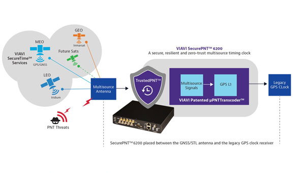
A GNSS clock is a single point of failure and is at risk of cyber-attacks that are on the rise, such as jamming and spoofing. In a typical configuration, a GNSS legacy clock includes an antenna, a receiver, a holdover oscillator and fan-out input/output. The GNSS antenna is the point of attack for many bad guys. That’s the problem we are addressing in the critical infrastructure that we are serving, including defense, 5G, public safety, utilities, data centers, financial systems and transportation. Bad guys now have also demonstrated that they can jam or even, in Russia’s case, shoot down GNSS satellites, which makes GNSS even more vulnerable, both in space and on the ground. GNSS constellations do not have spoofing detection or mitigation through authentication, except for Galileo’s Open Service Navigation Message Authentication (OSNMA). Additionally, their signals are not encrypted, so they are easy to spoof and do not work indoors.
What is your solution?
Instead of replacing the hundreds of thousands of legacy GNSS clocks that are deployed, we are just adding our box in line between the antenna and the receiver, as an accessory. We call it the zero-trust multisource PNT clock, and it is our new SecurePNT-6200 product. Additionally, we offer our new suite of SecureTime services, which combines multiple signals of opportunity, coupled with the 6200 clock. We already have Iridium LEO and Inmarsat GEO sources and will soon add support for other future satellites as well as terrestrial sources. You can even aggregate a stand-alone cesium clock into our resilient 6200 clock. Then, we output the legacy signal to feed it to the GPS receiver.
Our resilient multi-source clock aggregates all those signals of opportunity, and then AI sensor fusion weighs, cross-verifies, authenticates, qualifies. It does a lot of processing to select the best uncompromised source. The source is then converted to the legacy GPS L1 signal before feeding it to the GPS receiver. We call it a transcoder and have a patent on this technology. We are the only company offering this solution, though we allow third parties to do the same.
How are you processing your data?
We’re inputting all the constellations — almanacs, ephemerides, etc. — and fusing all those internal and external sources, weighing their quality and estimating the PNT state. We then apply the zero-trust, AI-based jamming and spoofing detection and mitigation. So, we’re doing the authentication, the verification, the qualification, the learning of patterns using all the data sets that we are accumulating between those different sources from GNSS, LEO, GEO or cesium clocks. We can also aggregate sources from the ground, such as eLoran or any terrestrial source that could be activated in the next two or three years. When we switch from one source to another — in the sky, in space, and/or on the ground — we go quickly into holdover so that we don’t have a phase hit during the switchover.
What is your timing source?
Our ground control stations are connected to the NIST to provide a GNSS-independent timing source. So, our solution doesn’t depend on GNSS and its coverage is global and traceable to UTC.
How do LEO and GEO complement each other?
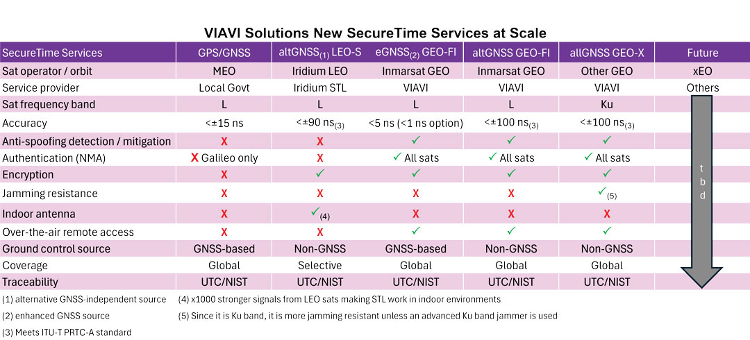
Through Iridium LEO, we’re addressing the encryption, jamming protection, and indoor antenna capabilities that GNSS does not have. However, there are still two missing pieces: spoofing detection and authentication. To address those two gaps of Iridium, we have Fugro Inmarsat GEO, both in L-band and Ku band. Some end users have already approached us and will receive a combination of all three sources — GNSS, LEO and GEO. By the time you get all of those, if anything happens in a critical infrastructure, you’re covered. It is just a matter of your risk profile and how much you want to pay for these services. There is not one service that fits all. The pros and cons of each service are presented in the table above.
What unique capability does VIAVI offer?
We are the only company today that can provide multi-orbit, multi-constellation, multi-band capability. All the solutions — GPS, Iridium and Inmarsat — are L-band, but we are going to come out with Ku band capability, too. Jamming and spoofing Ku band will be much, much more difficult than doing it in L-band, which has already been jammed and spoofed in known warzones, because the frequency is so high and if you get jammed, you can easily switch to a different transponder, and there are many of them. For the defense applications that we are serving, this capability can be the difference between winning or losing a war. We have many engagements with defense accounts, as well as commercial and government accounts and our solution has been embraced very successfully so far.
What performance have you achieved?
We have built spoofing detection into our product for defense-in-depth attacks. We are offering 5 ns accuracy to UTC and can go down to 1 ns accuracy using our new SecureTime eGNSS service. That is breakthrough performance. If you look at GPS, we are at 15 ns with a high-end receiver, but typical receivers are in the 20 ns to 30 ns range, so we’re at least 15 times better than that.
To detect jamming and spoofing, we see all the different signals from space and ground, if any, and map them into our AI fusion software platform that we have, which is our new TrustedPNT technology. These services have been tested and proven in live-sky battlefield scenarios at USAF’s NAVFEST 2024 Test Event in May 2024, including successfully providing assured PNT in a simulated warzone with complete denial of GPS and GNSS services. When attacked, our solution switched from GPS to LEO source and then from LEO to GEO, while surviving the various jamming and spoofing attacks. Once the attack stops, we fail back to GPS. If we add more sources, we will be able to switch from one to another depending on the relevant weaknesses, while amalgamating the different sources to create a solution that is higher in performance than any one constellation by itself.
In conclusion?
Adding an accessory costs a lot less than replacing your legacy clock. Additionally, adding diversified sources from multiple orbits and bands can significantly bolster the robustness and survivability of your overall PNT solution.
GNSS — delivering up to millimeter accuracy from 20,200 km in space with a received signal of one tenth of one millionth of one billionth of a Watt — is, in Arthur C. Clarke’s famous definition, “indistinguishable from magic.” Yet, in addition to the inherent errors in the transmission, propagation, and reception of their signals, GNSS are increasingly challenged by jamming and spoofing attacks, especially in and near conflict zones.
For that reason, as any regular reader of this magazine knows, combating jamming and spoofing and building resilience in positioning, navigation, and timing (PNT) systems has been a constant theme of many of our articles and industry news items for years.
The U.S. National Space-Based Positioning, Navigation and Timing Advisory Board has been focusing on how to “protect, toughen and augment” GPS, with the third word referring both to enhancements to GPS and to the “provision and use of alternate sources of PNT that complement, back up, or replace (partly or entirely) use of GPS.”(*)
For this cover story, I discussed complementary sources of PNT with executives from four companies that design, produce, and/or operate them. They cover a wide range of complementary PNT technologies. Read the exclusive interviews below:
Iridium owns and operates a constellation of satellites in low-Earth orbit (LEO) and has global rights for L-band spectrum. This enables it to operate the Satellite Time and Location (STL) system developed by Satelles before it recently became part of Iridium. STL protects critical infrastructure by providing a timing signal that is independent of GNSS constellations and 1,000 times stronger than the GPS signal.
Spirent Communications’ latest simulation system brings together GNSS and a wide range of other PNT systems. It simulates L-band, S-band, alternative navigation signals, signals of opportunity and emulated inertial outputs. It focuses particularly on the new and emerging LEO constellations, including Xona Space Systems’ PULSAR signals, and enables users to inject new signals via I/Q data files.
SpacePNT has developed an FPGA-based hardware/software/firmware spaceborne GNSS receiver technology specifically targeting the fast-growing New Space satellite market. The company’s innovations include a precise orbit determination algorithm that can process signals from the Galileo High Accuracy Service and from geostationary orbit (GEO) satellites.
VIAVI Solutions has developed a system that aggregates signals of opportunity, as well as Iridium LEO and Inmarsat GEO sources; weighs and cross-verifies them; then converts the output to the legacy GPS L1 signal and feeds it to a GPS receiver. It can also aggregate a stand-alone cesium clock.
(*) From Dr. John Betz’s presentation on “Augmenting GPS for Critical Infrastructure” at the April 24, 2024, meeting of the PNT Advisory Board.
In my last newsletter, I highlighted the release of a beta version of a new NOAA CORS Network (NCN) Station Web Page. As demonstrated in my newsletter, each CORS in the NCN has its own page with data, metadata, maps and photos for that station displayed in a modular layout so information is easily found all in one location. This past month, I had the privilege of participating in a meeting with representatives from the American Association for Geodetic Surveying (AAGS), the National Society of Professional Surveyors (NSPS) and the National Geodetic Survey (NGS). As a Past President of AAGS and the current Chair of the AAGS Membership Committee, I participate in these quarterly meetings.
AAGS aims to lead the community of geodetic, surveying, and land information data users through the 21st century. AAGS members develop new educational programs, including presentations, seminars, and workshops on topics related to geodetic surveying; and articles and papers that inform the membership of the latest scientific and technological developments and how to implement them in the most cost-effective and efficient manner.
In my previous newsletters, I have reminded everyone that time is running out to obtain a working knowledge of the new, modernized National Spatial Reference System (NSRS). The release of the new, modernized NSRS is only about a year away. As of July 2024, NGS plans to have a beta version of the new, modernized NSRS available around the summer of 2025 for users to test and evaluate new products and services. After enough testing has been performed, the new, modernized NSRS will be officially published – probably in early to mid-2026.
At the meeting, NGS highlighted some new products on its Alpha Preliminary Products site. The alpha site provides products that are useful for individuals who want to obtain a better understanding of the products that will be distributed as part of the new, modernized NSRS.
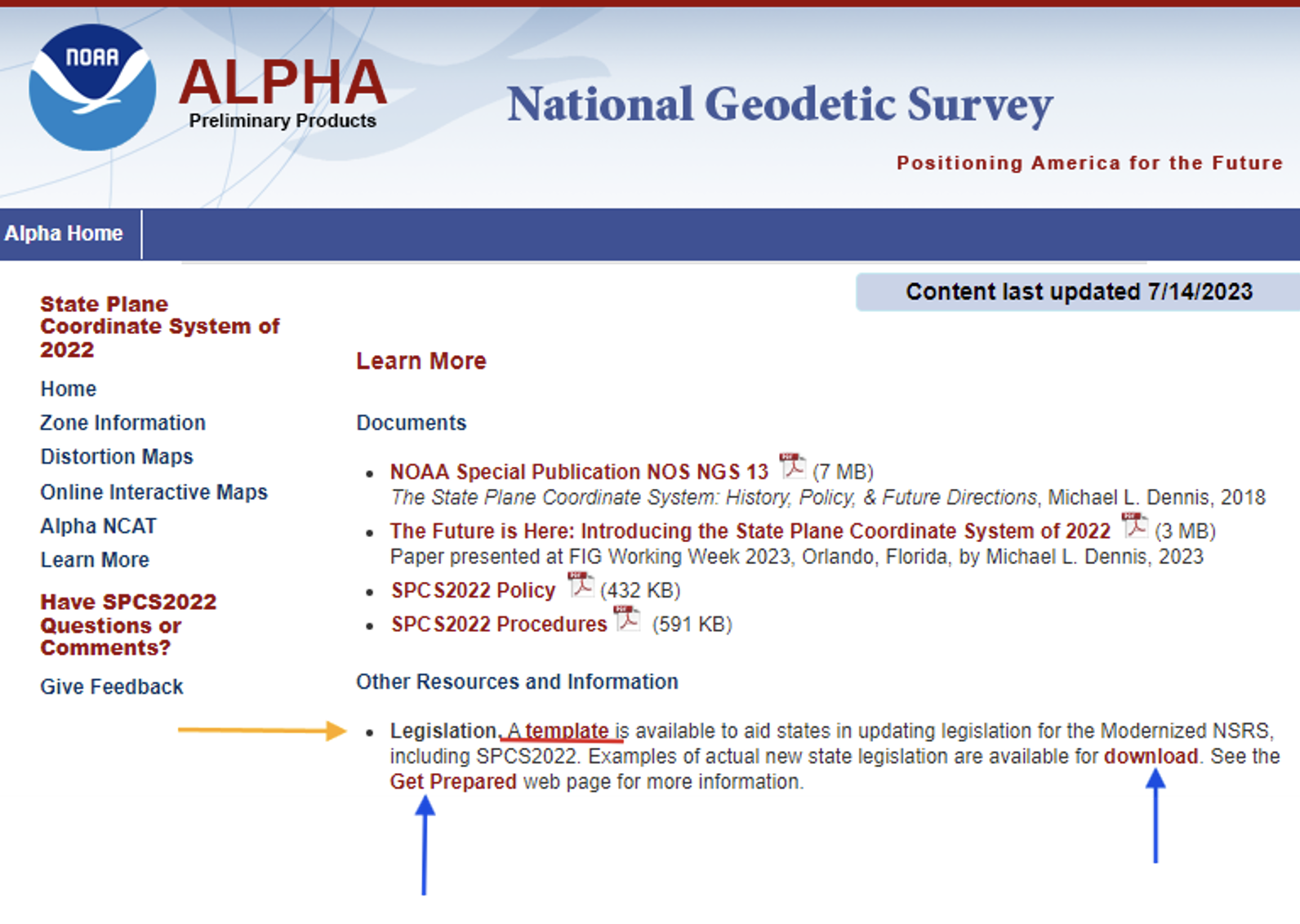
First, I want to bring attention to the importance of ensuring that the state’s legislation is modified or rewritten, if required, to include that the current horizontal and vertical datums are being replaced with the new, modernized NSRS. The “Learn More” button on the SPCS2022 Alpha site provides information about legislation.
Per personal communication with Michael Dennis, Ph.D., NGS SPCS2022 Manager, as of June 26, 2024, the following 12 states have have enacted into law NSRS modernization: Alaska, Idaho, Iowa, Kansas, Kentucky, Louisiana, Nebraska, North Carolina, South Dakota, Vermont, Washington, and Wyoming.
Users can download examples of actual new state legislation here.
Examples of legislation.
During the joint AAGS/NSPS/NGS meeting, Tim Birch, the executive director of NSPS, said that anyone who has questions about updating legislation for the new, modernized NSRS, including SPCS2022, can contact him directly.NSPS has experience working with agencies and individuals to develop legislation as indicated in the following statement on the NSPS website.
“We are the voice of the professional surveying community in the US and its territories. Through its affiliation agreements with the respective state surveying societies, NSPS has a strong constituency base through which it communicates directly with lawmakers, agencies, & regulators at both the national and state level. NSPS monitors and comments on legislation, regulation, & policies that have potential impact on the activities of its members and their clients, and collaborates with a multitude of other organizations within the geospatial community on issues of mutual interest.”
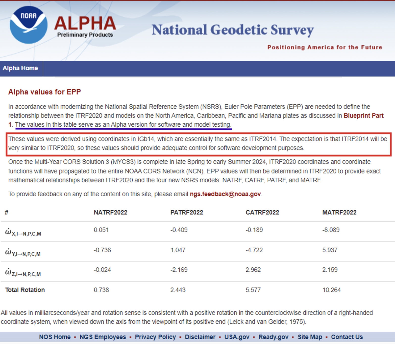
As previously stated, the two latest alpha products are the “GEOID2022 Alpha” and “Alpha Values for EPP.” My December 2017 newsletter discussed GEOID 2022 and the North American-Pacific Geopotential Datum of 2022 (NAPGD2022), and my February 2022 newsletter discussed the Euler Pole Parameters process and use in the new, modernized NSRS.
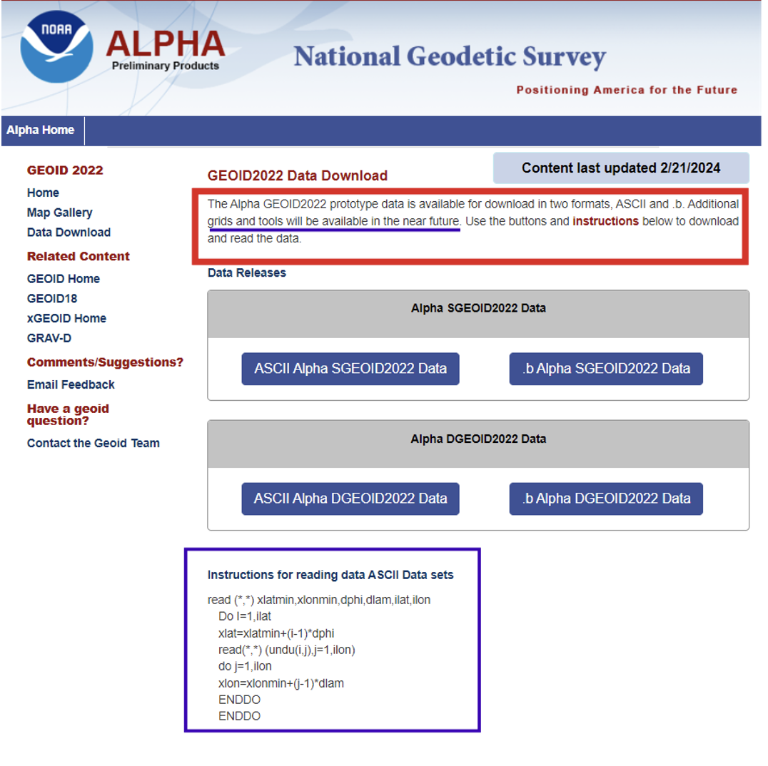
The GEOID2022 Alpha page provides a version of GEOID2022, which is the most recent prototype of the geoid models. The reference ellipsoid is Geodetic Reference System 1980 (GRS 80, but the geometric reference frame is ITRF2020). The Alpha GEOID2022 prototype data is available for download in two formats, “ASCII” and “.b.” There is a static component (SGEOID2022) and a dynamic component (DGEOID2022). These grids will be useful to programmers who want to develop and test their systems. Additional grids and tools will be available in the future.
Technical Details of the Alpha prototype of GEOID2022
GEOID2022 alpha is the last prototype of GEOID2022. It covers three regions: the North America–Pacific region, Guam and Northern Mariana Islands, and American Samoa. The spatial resolution of the geoid model is 1 arcminute. The geoid heights, which are in the tide-free system, are with respect to the reference ellipsoid of the Geodetic Reference System 1980 (GRS80) in the ITRF2020 geometric reference frame. GEOID2022 alpha includes static and dynamic components for the geoid heights. For detailed fundamental parameters of the geoid model, refer to NOAA Technical Report 78.
GEOID2022 Alpha
The Alpha EPP site provides the Euler Pole Parameters (EPP) that are needed to define the relationship between the ITRF2020 and models on the North America, Caribbean, Pacific and Mariana plates as discussed in NGS’s Blueprint Part 1 document.
Alpha Values for EPP
As stated in Blueprint Part 1, NGS will define the official relationship between ITRF2020 and the four NSRS TRFs through equation 59, using the rotation matrix in equation 58 resulting in equation 60.
I programmed this using a simple Excel spreadsheet to compute some of the potential changes between epochs for North Carolina. They were very similar to the ones that I depicted in my February 2022 newsletter that discussed the Euler Pole Parameters process and provided plots depicting the movement.
I would like to highlight the latest information available on the State Plane Coordinate System of 2022 alpha site. As previously stated, in about a year, the new, modernized NSRS will be available as a beta product. Users must get prepared by accessing NGS’s alpha products as well as taking the opportunity to provide feedback to NGS to improve their products and services. The Online Interactive Maps page provides information about the zones for every U.S. state and territory.
Clicking on the Online Interactive Maps link opens a NOAA ArcGIS online website that provides information about the Alpha State Plane Coordinate System 2022 preliminary zone designs. I have highlighted a few items that may be of interest to users.
The site provides a description of the site, links to various types of zones, links to data sources and information about distortion.
SPCS2022 online interactive maps.
Clicking on the link for zone definitions provides a list of zones and their parameters. This same information is also provided when users click on a zone on the map. I will demonstrate this later in this newsletter.
Per personal communication with Dennis, as of June 26, 2024, seven states have some or all their SPCS2022 zone definitions formally finalized, consisting of 205 out of the 965 zones (the total number of zones is still preliminary):
Alaska (partial coverage multizone layer)
Arizona (both multizone layers)
Idaho (both multizone and statewide)
Kentucky (both multizone and statewide)
North Carolina (statewide zone; it has no other zones)
South Dakota (both multizone and statewide)
Wisconsin (multizone)
Dennis informed me that the information on the alpha SPCS2022 Experience has been updated. He told me that the total number of zones decreased from 967 to 965, but based on coordination with the International Association of Oil & Gas Producers (IOGP) Geodesy Subcommittee the number may eventually increase to 972 (more about that in a future newsletter).
He stated that his goal is to finalize the zone definitions by the end of this calendar year or early 2025. Users should keep checking the alpha site.
Dennis mentioned that the website now offers a new feature that provides the distortion value when users click on the map. A nice thing about that is the site can be used on a smartphone, allowing users to obtain real-time distortion information from their location.
Clicking on the link titled “View” in the upper right corner of the box brings up a map that depicts the SPCS2022 zones.
View of ALPHA (preliminary) SPCS2022 zone designs.
When you click on the note about the ALPHA being preliminary, the map underneath appears where the user can select the type of maps they wish to review.
The following options are available: All Zone Layers, Statewide Zone Layers, Multizone Complete Layers, Multizone Partial Layers, and Special Use Zone Layers.
Users can use their mouses or the “+” button on the left-hand side” to zoom to a particular region, or use the search button on the right-hand side to select a State or zone.
Using the search box.
Information about a particular zone pops up by clicking on a point on the map.
Detailed information provided for a zone.
Each zone provides links to other features based on the location of the point selected on the map.
The image below provides the distortion in ppm for the point selected on the map.
The Alpha NCAT site can be used to obtain an estimate of the changes between SPCS83 and SPCS2022. It should be noted that all values will be in meters (m) and international feet (ft).
International feet may be new to some surveyors who were previously using the U.S. survey feet in SPCS83. The U.S. survey foot will not be used with the NSRS, including SPCS2022 coordinates. NGS and the National Institute of Standards and Technology (NIST) have taken action to deprecate the U.S. survey foot. What does that mean?. NIST has the following statement on its website: “Beginning on January 1, 2023, the U.S. survey foot should be avoided, except for historic and legacy applications, and has been superseded by the international foot.” This means that NGS will not be publishing SPCS2022 in U.S. survey feet but all historic products and services such as SPCS83 will still be provided in U.S. survey feet (sft) and international feet (ift).
More information and resources about the deprecation of the sft are listed below (personal communication from Dennis):
The official announcement is the final determinationFederal Register Notice (FRN) on deprecation of the sft issued on 10/5/2020. It was jointly issued by the National Institute of Standards and Technology (NIST) and NGS. I encourage everyone concerned about this topic to read it closely and in its entirety; it can likely answer most questions. The FRN includes information on the continued use of sft for legacy applications (such as SPCS 83). That is stated in the last paragraph of the “Notice of Final Determination” section; in items #1 and #2 in the “Counterpoints to Feedback Expressing Opposition”section; and in the second paragraph of the “Implementation Summary and Actions” section.
The legacy issue is also addressed in the 10th FAQon the NIST website and in the 11th FAQon our “new datums” FAQs web page.
The 40 states that officially adopted the sft for SPCS 83 are listed in Table C.1 of Appendix C of NOAA Special Publication NOS NGS 13, “The State Plane Coordinate System History, Policy, and Future Directions.”
Although the final determination FRN is itself not a law, Congress has passed several laws giving NIST the authority to maintain national standards of measurement. These and other related federal laws are given in the initial sft FRNissued on 10/17/2019.
An NGS webinar given on 11/10/2022 addresses the deprecation of the sft in the context of state plane. Two previous NGS webinars also provide additional background and historical information on the sft, one given on 4/25/2019 and the other on 12/12/2019.
Input to Alpha NCAT.Photo:Output from Alpha NCAT.
This newsletter highlighted the products on NGS’s Alpha Preliminary Products site. The alpha site provides products that can be useful for individuals to obtain a better understanding of the products that will be distributed as part of the new, modernized National Spatial Reference System (NSRS). NGS is providing these products on an alpha site so that they can get feedback from users. I would encourage all users to access the alpha sites and provide comments to NGS so that their products and services better meet the needs of the surveying and mapping community.
Welcome to the NGS National Spatial Reference System (NSRS) Modernization Alpha Product Release Site. This site provides examples of the content, format, and structure of data and products that NGS plans to release as a part of the Modernized NSRS.
Products found on this page are for illustrative purposes only and do not contain any authoritative NGS data or tools. They are under active development and are subject to change without notice.
To provide feedback on any of the content on this site, please email [email protected].
“Seen & Heard” is a monthly feature of GPS World magazine, traveling the world to capture interesting and unusual news stories involving the GNSS/PNT industry.
Songs for the Cows
Photo: SWNS Media Group
Farmers are controlling cows with a GNSS-based tracking system that plays “Waltzing Matilda” when they get too close to a virtual fence. Blue Carbon Farming in Somerset, England, has begun working with the Wildlife and Wetlands Trust (WWT) to allow cattle to graze in wetlands and salt marshes for the first time in 30 years. Farmers can now use the Nofence app and collars to track where the cows are and warn them away from danger with music. If a cow gets near the virtual fence, a boundary determined by the farmers, its collar will play the tune to warn it away from the area.
Robotic Dogs on a Mission
Photo: BMW
BMW is using a four-legged robotic dog to gather data for a digital twin at its Hams Hall engine production plant in the United Kingdom. The robot – a Boston Dynamics Spot model, which BMW has renamed Spotto – also will act as a watchdog and assist in other tasks at the site’s facilities. The autonomous robot is equipped with visual, thermal and acoustic sensors. The Hams Hall digital twin operates on three levels. On the first level, the twin generates 3D representations of the plant. The mobile robot feeds data into the second level – a data layer that also receives information from the site’s production facilities and IT systems. On the third level – the application level – programs sort the collected data, which personnel use for quality assurance and production planning purposes.
Keep Your Hands on the Wheel
Photo: Tesla
The U.S. Department of Justice has launched an investigation into Tesla’s Autopilot and Full Self-Driving (FSD) systems. Tesla is under the microscope of U.S. federal prosecutors, as well as the U.S. National Highway Traffic Safety Administration (NHTSA), who want Tesla to share more information related to its autopilot system after crashes continued occurring despite a December recall of more than 2 million vehicles. The investigation focuses on Tesla’s Autopilot system and the more advanced Full Self-Driving package, which the company has been selling as an optional add-on. Neither system can fully automate the driving process without human supervision, a point of contention that has raised questions about the accuracy of Tesla’s promotional materials.
Mass Coral Bleaching
Photo: Rainer von Brandis / iStock / Getty Images Plus / Getty Images
The Australian Institute of Marine Science (AIMS), in collaboration with the Great Barrier Reef Marine Park Authority, has observed extensive coral bleaching caused by elevated sea temperatures during aerial and in-water surveys of the reef. This information confirms that a mass coral bleaching event is taking place on the Great Barrier Reef, which is the fifth such event since 2016. The aerial surveys have so far covered almost two-thirds of the Great Barrier Reef Marine Park.
Some people may have anticipated that the unmanned aircraft industry, amid initial exuberance over the new technology and the impact it has made, would eventually suffer some sort of implosion. Nevertheless, while some smaller players have come and gone, by and large new companies are still sprouting, and other start-ups may have been absorbed by bigger fish with more resources.
DroneDeploy acquired a couple of software image acquisition and robotics companies in recent years – both StructionSite (2022 acquisition, San Francisco) and Rocus (2021 acquisition, New Zealand) are now part of DroneDeploy, widening their jointly addressable markets.
Drone Delivery Canada (DDC) is in the process of merging with Volatus to bring a combined service and equipment capability to market. Both companies are currently listed on the Toronto Stock Exchange and will trade under DDC’s stock symbol “FLT” following the completion of the merger, anticipated by the end of Q3 2024. DDC provides a unique Condor cargo UAV capability, remote operations center, cargo infrastructure and operations software, while Volatus provides UAV services, training and equipment sales to enable a path to market for the combined company.
Condor UAVs can carry approximately 400lb of cargo. (Photo: DDC)
Joby has been a leading participant in the emerging eVTOL air-taxi market segment, and acquired radar developer Inras GmbH in Linz, Austria in December 2021. The small Inras team brought advanced radar technology to Joby’s eVTOL development to provide onboard sensing and navigation.
Now Joby has also acquired the autonomy division of Xwing, which brings, according to the Joby website, “autonomy, including vision system processing, detect and avoid algorithms, mission management and decision making, ground control stations, remote operations and also the integration of Artificial Intelligence (AI) and machine learning algorithms.”
Joby’s two flying pre-production eVTOL aircraft (Photo: Joby)
The Xwing Superpilot software has previously enabled autonomous ‘gate-to-gate’ flight, 250 self-contained flights and 500 auto-landings with a Cessna 208B Grand Caravan for demonstration/tests. This system resulted in an official project designation for the certification of a large unmanned aircraft system (UAS) by the Federal Aviation Administration (FAA) in April 2023, and an Air Force Military Flight Release in 2024. Joby expects the acquisition to not only further long-term autonomous civilian capability — initial FAA certification is anticipated with piloted aircraft — but also to support existing and future business with the United States Department of Defense (DOD).
Meanwhile, Airbus is taking a similar approach by teaming with Helsing in Europe to integrate AI into a future Airbus unmanned Wingman concept aircraft — a UAV designed to fly with and be controlled by front-line manned fighter aircraft. Alongside growing European force requirements, Airbus envisages a lower-cost, attributable, UAV commanded by manned aircraft that could dispatch the Wingman for target reconnaissance and destruction or electronic jamming and deception of enemy air defense systems.
Airbus and Helsing CEOs with Wingman model.(Photo: Airbus)
Both Joby and its rival Archer have also received FAA Part 135 certification, which allows them both to run an air-taxi operation. Neither has yet obtained FAA authorization for their eVTOL aircraft, but both appear to have a clear mandate from the FAA for the steps necessary for those certifications. Both intend to operate existing certified fixed-wing aircraft as air taxis in the meantime under the Part 135 authorization.
While browsing through the FAA’s Special Class Airworthiness Criteria for the Joby Aero Model JAS4-1 Powered-Lift, published on the Federal Register, I learned that the task to certify a brand-new category of aircraft is huge — not big, absolutely gigantic.
FAA put together a draft of proposed cert criteria and put it out for comments to interested government agencies and industry — a whole slew of comments were received, which the FAA reviewed. The FAA incorporated some and discarded others. Just the response to these comments goes on for many pages — there were a lot of comments. Nevertheless, just skimming through FAA’s responses to these comments was a significant undertaking, never mind reviewing and understanding the basic requirements for, say, the two-performance option. Imagine what eVTOL operators have to go through to demonstrate that they meet the steps to achieve FAA certification.
The cert basis for Joby appears to be a combination of fixed wing and helicopter requirements, plus more to address the novel electrical propulsion system and the batteries that provide its power. Two levels of performance standards are set out — an “essential” level and an “increased” level. The 42 organizations that commented on the draft requirements included worldwide aviation agencies, eVTOL and aircraft companies, industry associations and major components suppliers, the Association for Uncrewed Vehicle Systems International (AUVSI) and some individuals — a huge group of involved and impacted organizations.
Joby applied to the FAA in November 2018 for certification of its Model JAS4-1 powered-lift eVTOL. Joby has been supporting just the activity related to certification for six years to date. All the other eVTOL developers are at a very similar stage as they try to get their aircraft into service carrying people and generating income.
Most eVTOL developers have major sponsors familiar with the certification process. Otherwise, the effort would just be too costly, never mind the cost of proving the capability to operating customers, the country as a whole and capturing the imagination of intended users. Plus, of course, building and qualifying the test vehicles, and the operational infrastructure to allow these eVTOLs to land, pick up customers and fly them to somewhere near their destination. The length of time to do this over so many years has broken many unwitting start-up companies. Achieving this goal can be incredibly difficult without the substantial financial resources of major companies such as Airbus, Boeing, or major airlines.
Moving from UAV to passenger airplane is something not to be taken lightly. As a potential future passenger, just keep waiting for your first flight in an operational certified eVTOL. Several of the contenders have targeted 2026, but who knows? I wish them the best of fortune and they’ll need it!
The solar storm in May that produced a beautiful aurora borealis as far south as Mallorca, Spain, also stopped GNSS-based precision agriculture for a couple of days. The same month, articles in major U.S. newspapers detailed aspects of a growing confrontation between the United States, Russia and China —vying for dominance in near-Earth space, now part of the military fighting domain — that could lead to far greater disruption. Nearly all satellites are highly vulnerable to cyberattacks, ground- or space-based lasers, high-powered microwaves, the debris field from a destroyed satellite and the radiation produced by a nuclear explosion in space. The last one would disable by far the greatest number of satellites because of its range and because commercial satellites, which constitute more than 90 percent of all satellites in orbit, are not hardened against such radiation.
Luccio
A May 16 article in The Wall Street Journal titled “Russia Launched Research Spacecraft for Antisatellite Nuclear Weapon Two Years Ago, U.S. Officials Say,” reported that in February 2022, shortly before it invaded Ukraine, Russia launched Cosmos-2553, “designed to test components for a potential antisatellite weapon that would carry a nuclear device.” It linked the launch to a continuing Russian nuclear antisatellite program and said that, if deployed, the weapon “would give Moscow the ability to destroy hundreds of satellites in low-Earth orbit (LEO) with a nuclear blast.”
“The Pentagon,” the article pointed out, “has become increasingly reliant on commercial satellites.” In LEO, it reported, there are almost 6,700 U.S. satellites, while China has 780 and Russia only 149. Therefore, the Russians would have a lot less to lose should they choose to explode a nuclear weapon in LEO.
A May 17 article in The New York Times was titled “New Star Wars Plan: Pentagon Rushes to Counter Threats in Orbit.” The subhead read: “Citing rapid advances by China and Russia, the United States is building an extensive capacity to fight battles in space.” It said that, in a major shift in military operations, the Defense Department “is looking to acquire a new generation of ground- and space-based tools that will allow it to defend its satellite network from attack and, if necessary, to disrupt or disable enemy spacecraft in orbit.” Meanwhile, “both Russia and China have already tested or deployed systems such as ground-based high-energy lasers, antisatellite missiles or maneuverable satellites that could be used to disrupt [U.S.] space assets.”
The decision to strengthen U.S. warfighting capacity in space, it said, is driven mostly by China’s expanding fleet of military tools in space, which threatens to prevent U.S. Navy operations in the Western Pacific. “The Pentagon is separately working to launch a new generation of military satellites that can maneuver, be refueled while in space or have robotic arms that could reach out and grab — and potentially disrupt — an enemy satellite.”
These are all reasons to quickly develop and deploy a wide mix of complementary PNT solutions that would lessen reliance on GNSS satellites and, therefore, make them less of a target.
In a recently released paper, the respected analytics firm London Economics determined that the presence of backup systems at the Denver and Dallas Fort Worth airports prevented any noticeable impacts on air travel despite each having experienced a disruption of GPS signals for 24 hours or more. By contrast, recent GPS interference at an airport without a backup system caused scheduled air service to be canceled until an alternative to GPS was established.
Also important to the lack of impact at Denver and Dallas was that the signals interfering with GPS, with a few minor exceptions, only impacted aircraft in the air.
GPS is essential for the safe and efficient movement of aircraft and support vehicles on the ground at airports, as well as the transport of crews, passengers, supplies, and cargo to and from airports, communication systems, and numerous other services.
Backups needed for both air and ground
Previous work by London Economics has shown that disruption of GPS for these ground functions would likely cause numerous flight delays and cancellations. Delays in the arrival of flight crews, passengers and supplies, for example, would quickly upset flight schedules. If this happened at a major airport, such as Denver or Dallas Fort Worth, disruptions could ripple through the entire air transport system. Wide-spread delays, cancellations and schedule adjustments would bog down air travel across the nation, if not the world.
The incident in Denver was caused by an accidental transmission from a government installation on Jan. 21. 2022. It impacted aircraft within approximately 50 nautical miles of the airport and lasted 33 hours before the source was identified and turned off.
The Dallas incident began on Oct. 17, 2022, and affected aircraft within about 110 nautical miles. It continued for 24 hours before ending on its own. The source has never been identified.
Reducing aviation backups may be a bad idea
In addition to recognizing the value of terrestrial navigation systems for aviation, the London Economics paper cautions about moves in the United States and Europe to “rationalize” these systems by reducing their number. In the event of longer or widespread GPS disruptions, the impact of an insufficient number of terrestrial systems could be significant. The cancellation of air service to an airport in Estonia because of chronic GPS jamming is used in the paper as a cautionary tale.
Instead of reducing the number of old backup systems, London Economics suggests policymakers consider establishing more widely available sources of terrestrial PNT. Taking a fresh look might identify alternative PNT sources for aviation that could also be used by other critical infrastructures. Perhaps even in consumer applications as well.
U.S. government representatives were approached for consultation and comment for this paper and expressed their willingness to participate. Unfortunately, they were unable to obtain permission to do so.
London Economics’ work on this effort was commissioned by the Resilient Navigation and Timing Foundation.
The paper “Aviation GPS Incidents Show Importance of Backup Systems. Policy Makers Take Note.” can be accessed from the foundation’s online library here.
Wangjie Zhao, an employee of CHC Navigation. (Photo: CHC Navigation)
For decades, surveying — which consists largely of making measurements to determine the relative positions of points above, on or beneath Earth’s surface — had much higher accuracy than mapping for geographic information systems (GIS) — which is mostly based on aerial photogrammetry for base maps and field data collection of the locations of features. When I started in this field a quarter century ago, we typically classified GPS receivers as survey grade, resource grade or consumer grade, with “resource grade” referring to field data collection for GIS.
Today, however, the accuracy of all receivers has greatly increased — thanks to improved chipsets, new GNSS constellations, and a plethora of corrections services — and those three categories are no longer relevant. Therefore, surveying and mapping are increasingly overlapping.
For this cover story, I asked the same three questions about mapping and surveying to representatives of four companies.
CHC Navigation — Rachel Wang, product manager of survey and engineering product line
Hexagon — Craig Hill, VP marketing and services, surveying solutions, Leica Geosystems
Surveying and mapping are increasingly overlapping. What are the remaining differences between them, in terms of accuracy requirements and challenges in the field?
CHC Navigation
While advances in technology such as lidar and photogrammetry are narrowing the gap, there are still notable differences between surveying and mapping. Surveying often requires centimeter- or even millimeter-level accuracy at specific points. In contrast, mapping focuses on collecting dense 3D data over large areas. Although the accuracy of mapping point clouds is steadily increasing, the integration of ground-based GNSS data collection with aerial imagery and lidar is becoming widespread. Mapping tends to be less labor-intensive and involves fewer safety risks in the field, but it requires a unique skill set, particularly in point cloud processing.
Hexagon
Traditionally, surveying and mapping differ primarily in their accuracy requirements and application scales; however, this paradigm is changing with mapping becoming increasingly accurate. Surveying focuses on high-precision geospatial data of specific points. From road, rail and tunnel construction to high-rise buildings, there is no substitution for the precision delivered by surveying equipment and procedures. In contrast, mapping focuses on larger areas.
Recent advancements in sensor technology, including both airborne and mobile mapping systems such as the Leica CityMapper-2 and the Leica Pegasus TRK, have significantly improved the efficiency and precision of mapping, bringing it closer to the levels achievable with traditional surveying equipment.
OxTS
Surveying comes with a large overhead during the data collection process. It requires meticulous preparation and attention to detail to achieve high accuracy in the raw data. GNSS quality, lever arms, user operation, etc., can all cause problems later on. Getting any part of the process wrong can have major cost implications through having to redo the process.
Mapping is focused on the act of aligning that data to datums and control points after the surveying process is completed but it also requires major attention to detail in aligning coordinate frames and origin points in order to avoid baking in any errors that lead to mistakes being made once the map data is handed over to a customer
The problem is that if the surveying process wasn’t accurate, the mapping process will not have a solid foundation in the raw data to deliver accurate maps, so they are inherently tied to each other.
Trimble
Surveyors today have many tools in their toolbox, giving them flexibility across surveying and mapping applications. There are many highly accurate, easy-to-operate data capture systems to choose from these days, but challenges grow when combining and analyzing vast amounts of data from different sensors in the office to provide final deliverables. This has made field-to-finish software that delivers technological integration, workflow optimization and adaptability essential for the job.
Mapping projects often require less accuracy, but a lot of advanced survey technology is entering the mapping domain (e.g., mobile mapping and laser scanning) because of easier field operations and increasing understanding of the value of rich data to asset management.
The data were collected in and around a car park to prove how Lidar Inertial Odometry (LIO) can be used to retain accuracy for longer periods without GNSS updates. (Photo: OxTS)
What is your company’s niche in surveying/mapping?
CHC Navigation
CHC Navigation (CHCNAV) has been at the forefront of positioning and navigation for more than two decades, continually adapting to meet the diverse needs of the surveying and mapping industry. Our innovative solutions often lead the industry in providing end-to-end, integrated technology fusion — GNSS, inertial measurement unit (IMU) and imaging lidar — as a standard that empowers geospatial professionals worldwide. CHCNAV strives to provide accessible, value-added solutions from the start, positioning itself as a key technology enabler for the geospatial community.
Hexagon
Whether you are mapping an entire city or surveying a site for construction, capturing reliable and precise geospatial data is essential. Hexagon’s niche lies in its commitment to innovation, its extensive portfolio and the convergence of superior hardware, intelligent software solutions and expert services — enabling precise, efficient and scalable surveying and mapping for diverse needs. Our multitude of solutions, whether handheld, tripod-mounted, flying, or vehicle-mounted, are designed to collect data efficiently and safely from complex or dangerous environments — enabling the greatest accuracy and high-value deliverables.
Furthermore, Hexagon is uniquely positioned with its robust suite of software solutions that work seamlessly with our hardware, such as Reality Cloud Studio, Leica Cyclone, Leica Captivate or Leica Infinity for collecting, processing, modeling, analyzing, and presenting data. We offer end-to-end solutions that not only provide high accuracy but also ensure productivity and ease of use.
OxTS
OxTS offers localization and georeferencing technology that can help accelerate the collection of high accuracy survey data, allowing more work to be completed in a given time frame without compromising on accuracy.
Trimble
Trimble is known for offering a wide range of highly accurate and reliable data capture sensors but our “niche” — our truly unique offering — is our ability to offer comprehensive solutions that make our customers more productive and their projects more streamlined. We do this through hardware and software solutions that enable highly efficient survey and mapping workflows that connect field and office operations. Our software helps transform the captured data into true information utilizing an increasing number of AI-powered tools while our cloud services allow customers to share the data with a variety of stakeholders, unlocking the transformational power of geospatial data.
What is your latest surveying/mapping product? What are its key specs, markets and applications?
Hexagon
Among our surveying and mapping solutions, the Leica BLK ARC stands out with its flexibility to integrate with various robotic and mobile carriers. The BLK ARC provides autonomous laser scanning with static and dynamic scans, creating 3D digital twins and ensuring operator safety. Similarly, the Leica BLK2GO introduces an agile, handheld mobile scanning solution, capturing point clouds and images, with a user-friendly design. Both solutions are great allies for professionals requiring accurate, efficient, and versatile mobile scanning solutions.
For those looking to offer wide-scale data-capturing capabilities and overcome capacity constraints, the Leica Pegasus TRK mobile mapping system stands out because it can gather extensive data quickly and accurately. Its high-resolution data capture, advanced lidar technology, and enriched 3D point cloud capabilities ensure detailed and comprehensive datasets. Building on this range of solutions, the autonomous flying laser scanner Leica BLK2FLY enhances surveying efficiency by capturing hard-to-reach areas and environments. Its user-friendly operations, advanced obstacle avoidance and seamless cloud-based data integration make it a valuable tool for enhanced productivity and safety in surveying work.
CHC Navigation
Our latest offering, the RS10, demonstrates the integration of surveying and mapping technologies by combining GNSS RTK, laser scanning and visual SLAM into a unified platform. The RS10 enhances traditional GNSS capabilities with V-lidar and SFix technologies. V-lidar enables non-contact offset measurements up to 15 m, ideal for rover applications. Meanwhile, SFix technology leverages laser and visual SLAM data to deliver 5 cm accuracy within one minute in environments with weak or absent GNSS signals. This breakthrough enables accurate GNSS measurements in challenging environments such as indoor spaces and urban canyons, bringing simplified workflows and increased productivity to professional surveying and mapping.
OxTS
OxTS recently released Lidar Inertial Odometry (LIO), which offers improved localization in GNSS-obstructed environments while maintaining a fully global frame output. It means that survey data can retain accuracy for longer in harsher GNSS environments but doesn’t give up the global reference to coordinate frames used by surveyors and does not require ground control points to be anchored to those coordinate frames.
Trimble
The newly released Trimble Business Center (TBC) v2024.00 delivers on its commitment to innovation by offering technological integration and workflow optimization, as well as adaptability and innovation for the ultimate field-to-finish workflow. A key highlight in the new release is the seamless integration of survey data delivery for pavement inspection within AgileAssets, which bridges the gap between Esri and Autodesk through feature services for more efficient pavement management.
In addition, AI technologies provide enhanced point cloud classification and new feature extraction routines for game-changing analysis of aerial, terrestrial, mobile mapping and tunneling data. Collaboration also is greatly enhanced through Trimble Connect for seamless data integration across TBC and Trimble Access field software.
Josh Humphriss, surveyor at Storm Geomatics Limited, surveys a stream with a Trimble GNSS system in Shipston-on-Stour, Warwickshire, England in 2022. (Photo: Michael Dix, Marketing Communications Manager, Trimble, Inc.)