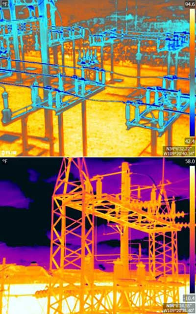
An Arizona electric cooperative that serves more than 33,000 customers is helping prove the value and potential of unmanned aerial systems (UAS) in enhancing the utility’s geospatial information system (GIS) effort.
Using an Intel Falcon 8+ Drone — Topcon Edition, UAS specialist Skynetwest is performing missions to illustrate the viability of UAS technology. Initial work for the Navopache Electric Cooperative (NEC) included inspection of a substation, conducted on a windy day that might have grounded traditional aircraft.
Windspeed limits for the Falcon 8+ in GPS mode are set at 26 mph; in height mode that threshold is extended to windspeeds as high as 35 mph.
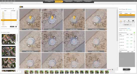
Using ContextCapture and Agisoft PhotoScan software, Skynetwest created a detailed georeferenced 3D model of the substation.
The Falcon 8+ also has triple-redundancy inertial measurement units (IMUs), double redundant compasses, dual-constellation GPS, eight propellers and two batteries. An algorithm selects the most accurate of the redundant systems to use when the UAS is flying near the electromagnetic frequencies emitted by power lines.
The team easily switched between a camera payload for inspections and one for mapping. Skynetwest’s mapping package takes high-resolution geo-referenced aerial images from various heights within set GPS tolerances. Its RGB camera delivers both orthophotos and 3D models in Topcon ContextCapture software, powered by Bentley Systems.
Few commercial UAV operations would be able to inspect transmissions lines, pipelines or train tracks without beyond visual line-of-sight (BVLOS) capability, but these key pieces of infrastructure often situate close to or transit across population centers. Further, many population centers have airports and low-level air traffic. Any tools to keep drones away from air traffic during BVLOS operations will significantly inspection companies. We review three promising solutions here.
Pipeline Inspection
Kongsberg Geospatial in Ottawa, Canada has developed location visualization software tools that are used for air-traffic control, command and control, and air defense applications. The company has several decades of experience in these applications. Its IRIS software was used to support recent UAV oil pipeline inspection operations in Nigeria, providing safety critical airspace deconfliction, supervised by the Nigerian Civil Aviation Authority (NCAA).
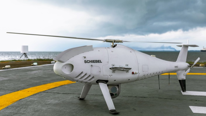
The pipeline project was undertaken by Aerial Robotix, a UAS services provider in Nigeria, who used adapted Kongsberg software in its control center to demonstrate safe BVLOS operations, and was then able to obtain the necessary permits. A Schiebel Camcopter S-100 UAV with a 200-kilometer BVLOS capability was used for flight inspection, operating both day and night, with real time high-definition payload imagery sent back to the control station.
Camcopter S-100 prior to BVLOS pipeline inspection flight in Nigeria. (Photo: Schiebel)
Nigeria has a major problem with gasoline theft from pipelines similar to those lines inspected during this project. Recently, 105 people perished in a blast from a ruptured pipe 30 miles north of the city of Umuahia, possibly during scavenging for leaking fuel. It has been claimed that the pipeline had been ruptured by saboteurs earlier, and for the following six weeks villagers had been collecting fuel. Pipeline vandalism is common in Nigeria, even given the risk of fire or explosion, or the risk of prosecution, or even the possibility of being shot on sight.
Unmanned Companion Fighter Aircraft
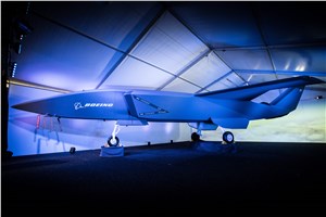
Boeing just unveiled a concept UAV which is apparently aimed at providing an airborne team-partner for manned aircraft.The concept was introduced at the Australian International Airshow by the Australian Minister for Defense, the Hon. Christopher Pyne MP. The project is slated for a significant R&D investment by the Australian Government and Boeing Australia.
Boeing Airpower Teaming System. (Photo: Boeing Company)Boeing Airpower Teaming System. (Photo: Boeing Company)
The concept model has fighter aircraft lines with a projected 2,000-mile range, autonomous capability, and significant intelligence, surveillance and reconnaissance sensor capability. Flying alongside manned fighter/attack aircraft with artificial intelligence simplifying control, the Airpower Teaming System is designed as a low-cost force multiplier.
The concept includes a pitch for international collaboration offering significant customization so countries can add local content, a key element for any aircraft program designed for off-shore sales.
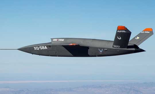
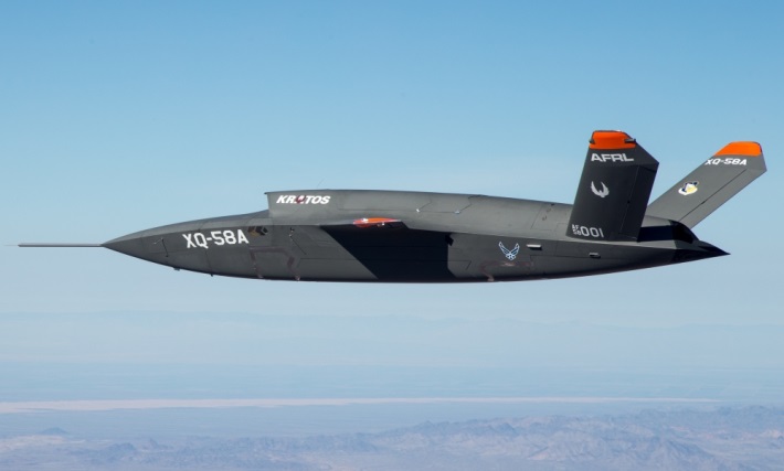
XQ-58A demonstrator in flight. (Photo: U.S. Air Force)
A day or so after the Airshow (maybe not wanting to be upstaged by Boeing’s announcement?) a release showed up about the first flight of the previously secret XQ-58A Valkyrie demonstrator. This is apparently a program by the US Air Force Research Laboratory (AFRL) partnered with Kratos Unmanned Aerial Systems to develop a UAS which looks to have very similar capabilities to that of the Boeing concept, perhaps at a significantly further advanced stage, with a much more mil-spec UAV sounding name.
The AFRL indicated that the XQ-58A is part of a Low Cost Attritable Aircraft Technology (LCAAT) (guess that means they don’t much mind losing a few) effort to come up with low-cost force multipliers which can be built quickly using commercial technology and operating from unprepared runways.
(From the Air Force: “The thought is to develop an inexpensive, configurable and producible on demand air vehicle. A number of military applications can be envisioned for an air vehicle with such a capability. One potential application is to use hundreds or thousands of such units in a campaign to overwhelm an enemy’s air defenses and “punch a hole” to enable higher value, less replaceable [aircraft] to engage or monitor enemy systems. Another potential application is to augment the capabilities of high-value intelligence, surveillance and reconnaissance, systems which may be limited in a specific campaign by distances, quantities, or threats. For all applications, the weapon system is expected to be an air vehicle that would return to base or to a separate location to be recovered. However, because of the mission and because of the low cost, the air vehicle would be attritable, meaning the Air Force would expect and could afford to lose many of the assets.”)
The current program took 2½ years to get to this flying prototype, which still seems pretty lengthy in terms of today’s commercial UAVs. The first flight from Yuma Proving Grounds in Arizona lasted an hour and a quarter and all went as expected. Five test flights are planned to check out functionality, aerodynamics, and launch and recovery systems. Kratos is perhaps better known for its family of target drones which have been in use by the US and internationally for some time.
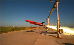
Kratos BQM-177 Navy drone declared operational. (Photo: Naval Air Systems Command)
Kratos Defense & Security Solutions, Inc. announced in early March that its BQM-177A Subsonic Aerial Target (SSAT) has achieved Initial Operational Capability as reported by the US Navy. A Navy statement said “The first site the BQM-177A will be operated from is Pt Mugu, California. The target is capable of speeds in excess of 0.9 Mach and a sea-skimming altitude as low as 10 feet which provides sea-skimming anti-ship cruise missile threat emulation for the US Navy.”
Parachute System for DJI Phantom 4
Recent testing of the descent rate of a Phantom 4 equipped with a SafeAir parachute system indicated that this UAV/parachute combination may well meet the FAA’s recently published draft rules for flight over people. The parachute system uses on-board indicators to trigger parachute deployment. ParaZero (manufacturer of the SafeAir UAV parachute system) has developed standards, and promises to provide customers with certification data to support waiver applications for flight over people.
Wrap-up
So now we have intuitive software using terrain data and sensor inputs which can provide a visual overlay to supports BVLOS flights, concepts designs and prototypes to support the ‘Loyal Wingman’ approach – flying UAVs alongside existing defense aircraft as force multipliers – and advances towards UAV flight over people using certified parachute safety systems. Just a flavor of the flurry of recent new developments in the world of unmanned aircraft.
A series of documentary videos on automation and technology in the construction and agriculture industries covers drone inspection of infrastructure among other new trends. Filmed in the U.S., the Netherlands, United Kingdom, and Germany, the series of brief films produced by Topcon Positioning Group emphasizes how technological advancements have changed infrastructure — how it is designed, built and maintained — and what to expect going forward.
“The infrastructure industry is changing quickly, and this video series highlights how this advancement is part of a larger story of technology changing the paradigm everywhere. To stay on top, businesses will need to adopt automation and new technology,” according to Topcon spokesperson Jackie Ferreira.
A spokesperson from Intel describes how drone inspection facilitated data gathering and project planning for a complex restoration project on the Great Wall of China, in an area with very difficult access.
Senators Joni Ernst (R-IA) and Tammy Duckworth (D-IL) joined Representatives Dave Loebsack (D-IA) and Don Bacon (R-NE) in launching the Congressional GPS Caucus in March. This bipartisan, bicameral caucus will elevate the ever-increasing importance of GPS technologies to the U.S. economy and infrastructure. As evidence of that, today more than 3.3 million jobs in the United States rely heavily on GPS.
Agriculture is front and center in the states and districts these policymakers represent, and the cost savings as well as jobs and family incomes are noteworthy. Nationwide, GPS has led to $8.2 billion in savings through precision agriculture, while yielding increases in grain production across the country. Further, GPS has become an indispensable and reliable part of the country’s national infrastructure. Public and private investment in GPS-based technologies and services have produced a steady stream of innovations, making the U.S. a global leader in the sector.
The GPS Caucus will prioritize ensuring GPS signals remain continuously available, accurate, reliable and resilient. To better support the long-term health and future of GPS, the caucus plans to host educational briefings and technology demonstrations, in addition to advocating for policies that keep GPS at the forefront. On April 2, these efforts will kickoff with a “GPS 101” educational briefing on the Hill featuring remarks from Senator Duckworth, Representative Loebsack, Colonel Curtis Hernandez, US Air Force Director National Security Space Policy, National Space Council and industry leaders from Deere & Company, Garmin and Trimble.
To further reaffirm the critical importance of GPS, the GPS Caucus introduced concurrent resolutions in both the Senate and House. The resolutions outline the economic benefits of GPS, totaling more than $68 billion to the U.S. economy each year, and the sectors GPS technology supports, none of which would be possible without the contributions made by the men and women of the Air Force who maintain the GPS constellation.
As efforts to advance 5G, precision agriculture and smart cities continue, GPS will only become more valuable to modern-day operations and it remains critical that policymakers, companies and industry leaders alike, foster policy that keeps GPS at the forefront.
Changes to the Federal Aviation Administration (FAA) operational drone restriction were recently proposed in order to allow some flights over people. This proposed rulemaking appears to be a major step forward. Mail-order delivery flights, newsgathering, real-estate sales movies and building inspection, to name a few markets, all begin to make more sense, maybe even become viable.
Some night operations could also be possible.
Risk assessment methodology appears to be logical; a number of UAV categories are proposed, and there is a way to assess if operators are in compliance.
The Alliance for System Safety of UAS through Research Excellence (ASSURE) undertook a ground impact study to determine the possible risk of injury to people from drones falling out of the sky. Assessments were made using existing automotive standards and a military standard for debris impact, plus there was testing using automotive crash dummies.
It was a lot of work, but the bottom line appears to be that possible injuries to people are more likely to be minor than major. Bear in mind that UAS fly at relatively low altitude, are made with materials that make them somewhat elastic in nature, and that it may be possible for people in a crowd to see a flailing, falling UAV and move to avoid an impact.
Nevertheless, I do have a picture in my mind of a wayward drone crashing to the pavement after hitting a skyscraper in San Francisco, and I’m really glad I wasn’t down on the sidewalk below.
Urban building inspection using drones. (Photo:AeroSIM RC)
Then I read an article by James Poss, a retired military major, who seems to suggest that although the conclusion of the ASSURE assessment was that 2,000 grams was an OK weight for an sUAV to avoid serious injury to anyone, the FAA appears to have proposed limitations for sUAS which are only 1/10th of this weight. This is more in line with the weights in the mil-spec standard that are based on small, fast, solid-metal blast fragments.
It might help us to also consider how often or badly people are injured by golf balls, baseballs, tennis balls or squash/racket balls — for instance, I’ve survived several golf ball impacts and even an impact with a squash racket during play without major damage. These are things we all take in our stride as part of (almost) normal human activity. I wonder how often recreational enthusiasts have actually been injured during model-aircraft flying gatherings?
FAA restricts flights over government facilities
In cooperation with the Department of Justice (DOJ) and the Department of Defense (DOD), the FAA has just established temporary restrictions on drone flights within 400 feet of the lateral boundaries of a number of sensitive federal facilities. This is in addition to previous restrictions over prisons, NGA facilities, DoD ships and other facilities.
The most recent proposed Notice to Airmen (NOTAM) lists federal correctional facilities in almost half of the states in the U.S., several medical centers, U.S. Army facilities, ammunition plants and Pearl Harbor in Hawaii. It’s hard to understand why there aren’t already permanent UAV prohibitions over all such sensitive facilities across the whole U.S. I tried to check status, but the FAA UAS Data Display System didn’t list this proposed NOTAM which apparently goes into force on Feb. 26.
Think it’s probably a question of preventing bad guys from planning or doing harm rather than being shy to be caught on video — but, for sure, these places should be as secure as possible.
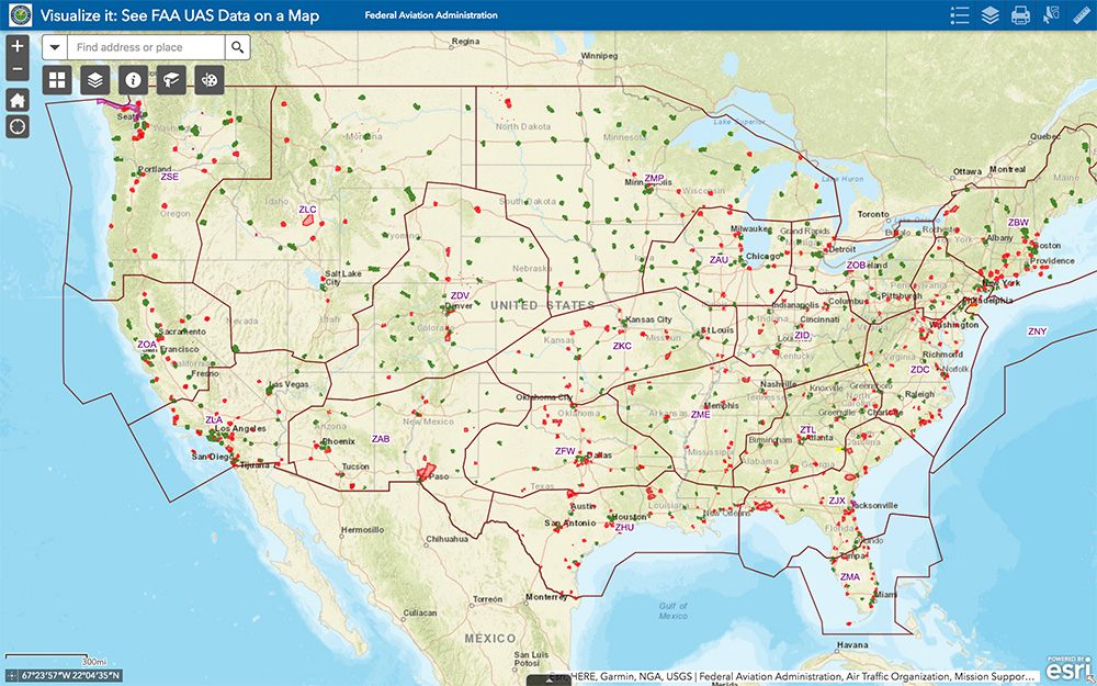
The FAA UAS data map shows all drone-restricted areas, once updated. (Screenshot: FAA)
Security at the Super Bowl
Well the game wasn’t the most exciting, with New England doing all that was needed to win in the fourth quarter, but the security for the event in Atlanta was humongous.
The area around the stadium was cleared of threats even before the game, attendees were screened for prohibited items and the airspace within 30 miles was restricted for general aviation and drone access. There were even Defense Department F-16 airspace patrols, and the Customs and Border Patrol had a Black Hawk helicopter available to intercept any aircraft penetrating the exclusion zone.
Nevertheless, the FAA still approved the operation of two tethered drones. One was flown close to the stadium by security personnel to provide live images of crowd movements in and around the stadium. The second system was operated at 45 meters above the rooftop of the CNN building facing the Mercedes Benz Stadium. CNN used it to provide aerial imagery of the scene before and after the game.
Elistair base station and DJI M200 at Super Bowl. (Photo: Elistair)
The tethered drone setup included two DJI M200 drones and two Elistair Ligh-T base stations, with monitoring, control and power provided to each drone by lightweight tethers. The security system was continuously operationed for 10 hours of captive flight during the Super Bowl, and for 14 hours total over two days — all while tethered to the Ligh-T control station. Security officials expressed their interest in using this solution more often because of the ability to follow a subject continuously without having to switch from one fixed camera to another, which risks losing the subject.
To sum up, new pending FAA regulations that support operations over people may have a few flaws. Other new FAA rules are aimed at protecting DOD and DOJ facilities from drone overflights, and tethered drones were used at the Super Bowl for crowd security and by CNN for color coverage.
New applications, new opportunities and preventive controls to maintain security at sensitive facilities — all moving in the right direction.
Are drones (UAVs) a disruptive or constructive technology for high-precision mapping that yields practical, actionable results for the end user/customer?
Ismael Colomina
“More constructive than disruptive. Drone mapping is opening new markets that, to a large extent, were not serviceable by conventional manned flights. On the other hand, the profound changes — and crisis — in the mapping business were not produced by drones.” Ismael Colomina GeoNumerics
Jean-Marie Sleewaegen
“Drones have dramatically reshaped the surveying and mapping industry. Combined with reliable positioning and recent advancements in high-resolution cameras, photogrammetry and computer vision, drones now enable high-accuracy mapping faster and at much lower cost than conventional mapping techniques.” Jean-Marie Sleewaegen Septentrio
Jules McNeff
“Drones can be constructive augmentations to high-precision map products because of their ready access to diverse locations. Drone imagery can document real-time physical changes that affect mapping applications during natural disasters or other events — but images alone aren’t maps without a geo-referenced grid such as the U.S. National Grid.” Jules McNeff Overlook Systems Technologies Inc.
Other members of the EAB
Tony Agresta Nearmap
Miguel Amor Hexagon Positioning Intelligence
Thibault Bonnevie SBG Systems
Alison Brown NAVSYS Corporation
Clem Driscoll C.J. Driscoll & Associates
John Fischer Orolia
Ellen Hall Spirent Federal Systems
Terry Moore University of Nottingham
Bradford W. Parkinson Stanford Center for Position,Navigation and Time
Virtual Surveyor drone surveying and mapping software has added new functionality that enables users to process larger projects without buying more powerful computers or cloud services, according to the company. This addition is one of several included in Virtual Surveyor 6.2.
“Our objective with Version 6.2 is to make our users more productive while saving them money by eliminating the need to invest in new hardware or processing services,” said Tom Op ‘t Eyndt, CEO of Virtual Surveyor in Belgium. “We have addressed the fact that drones are capturing more data at higher resolution, resulting in enormous files sizes.”
According to the company, Virtual Surveyor 6.2 solves the problem of large files by offering enhanced clipping and mosaicking functionality. The new version allows users to merge multiple smaller processed pieces of orthophotos and digital surface models into a single project and create smooth edges between these pieces with the new clipping tool. The mosaic can then be exported to a new tiff file or serve as the basis for a full area virtual survey.
In addition, Virtual Surveyor 6.2 offers a 3D Fly Through capability that allows users to select spatial bookmarks and waypoints in their scene and create a movie that allows the viewer to fly through the terrain in three dimensions.
Virtual Surveyor 6.2 also features improved surface handling for volume calculations. This feature was developed primarily for users who measure volumetrics of material piles in drone survey data. This capability makes it easy to represent topographies as triangles, contour lines or outlines without creating three different objects, the company said.
Other enhanced features of Virtual Surveyor 6.2 include a renumbering tool that allows users to select a set of times, features or geometries in the data set and automatically number them sequentially from any chosen starting number; concave hull extraction that allows users to select a section line to create a surface for a curved roadway; and boundary selection that allows users to trace around an unwanted feature and delete that object and all the points within it.
“The advantage of Virtual Surveyor is that it combines the interpretation skill of a professional surveyor with computing power to create standard survey products,” said Op ‘t Eyndt. “Surveyors can now accomplish more in Version 6.2 without expensive upgrades to other aspects of their workflow.”
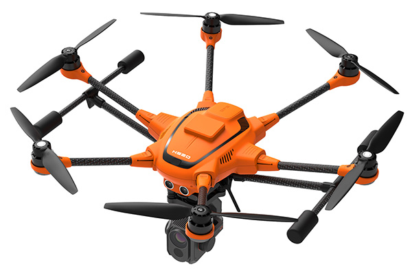
Yuneec International’s commercial hexacopter, the H520, will now optionally be available with an RTK (real-time kinematic) system from the Swiss company Fixposition.
Under difficult GPS conditions, such as in cities or canyons, the RTK system ensures maximum precision and centimeter-precise positioning. The fully integrated RTK satellite navigation enables extremely accurate recurring images and faster 3D mapping. It also makes automated inspection flights easier and more precise, the company said.
The new H520 RTK is suitable for commercial applications that require maximum precision. By using RTK technology, the H520 can now fly much closer to objects for inspection as the UAV positions itself precisely in the centimeter range (1 cm + ppm horizontal / 1.5 cm + ppm vertical) rather than in the meter range, which is standard for the H520.
This accuracy is paramount for applications where several images need to be taken at the same location on different days including:
documenting progress on construction sites,
inspecting mountain landscapes to prevent natural hazards such as rock falls or avalanches, and
forensic accident scene reconstruction.
In addition, the satellite navigation system makes it possible to significantly reduce image overlaps, which means fewer photos and shorter model calculation times, maximizing efficiency in workflows.
The RTK system is not only fully integrated into the hardware, but also into the UAV’s software. This means the user retains the full range of functions of the DataPilot software, including mission flights.
The H520 RTK works with two components: the RTK module on board the H520 and a base station on the ground. For precise navigation, the module supports constellations of up to three different satellite systems from GPS, GLONASS, Galileo and BeiDou.
If the use of a ground station is not possible, the system can also be operated with a national reference station network (network RTK). The network RTK is provided by third-party providers and requires an internet connection, such as a mobile hotspot. All data including satellite data is recorded, which makes the H520 RTK suitable for post-processed kinematics (PPK).
The H520 RTK will be available in the second quarter of 2019. Technical specifications are available here.
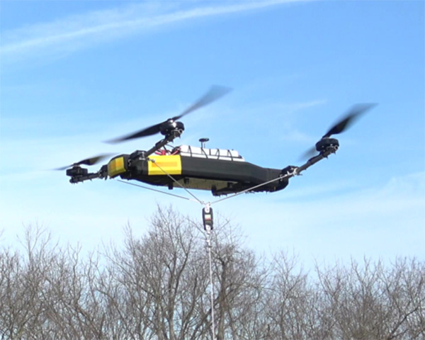
Mobile Recon Systems is offering an unmanned aerial vehicle that can lift more than its own weight.
At 78 pounds, the Dauntless multi-rotor UAV has lifted an additional payload of 100 pounds as a tethered quadcopter, the company said. It is designed to lift more than 200 pounds as an octocopter, with a generator-powered flight time of several hours.
Photo: Mobile Recon Systems
“Drones have proven to be great for videography. But uses beyond that have been limited by low lift capacity, limited flight time and narrow functional capability,” said Mobile Recon Systems founder Mike Dowell. “With the Dauntless, that is no longer the case.”
Not only can the Dauntless carry up to 160 pounds of supplies in a climate-controlled transport box, it is a multi-functional platform. It can be outfitted with sensors, radiation detectors, radar, weather stations, multi-spectral, thermal and infrared cameras, and other devices. It can perform eight or more different functions at once. Plus, users can easily swap or combine devices to meet their needs.
Those capabilities enable this model to deliver high value services previously out of reach for UAVs, the company said.
“The Dauntless is ideal for border and perimeter security, as well as natural disaster response, medical emergency first response, routine inspections and aerial analysis, and mapping,” Dowell said. “With its lift capacity, it can carry high-end lidar and cameras, as well as supplies. Our flexible platform offers a myriad of possibilities.”
To illustrate, the Dauntless can carry an MSOP and four multi-axis gimbals, mounted on top and bottom, to accommodate optical, thermal and multispectral cameras, including a RED Epic. high-end digital camera. These can simultaneously capture multiple types of images from below, front, overhead, right and left of the flying platform.
The Dauntless has a full 3K (military-grade) carbon-fiber body and titanium and aircraft aluminum frame. The propellers are carbon fiber, and are safely surrounded by the body. It is waterproof and sandproof.
Lidar USA’s Forrest Briggs introduces its new lidar systems for the DJI M200 and M210 drones at Intergeo 2018, which took place Oct. 16-18 in Frankfurt, Germany.
Datumate’s DatuSurvey 5.5 software offers 2D vectorized measurements and 3D point clouds models. (Screenshot: Datumate)
Datumate, a photogrammetry solution and 3D mapping software developer, has released its updated DatuSurvey 5.5 software, which offers 2D vectorized measurements and 3D point cloud models.
According to the company, with the updated software, users can now process thousands of images locally in an accelerated mode while maintaining survey-grade accuracy and professional engineering results. Organizations can also deploy Datumate’s solutions on single or multiple computers and take advantage of the accelerated and user-friendly processing of the project field data.
In addition, DatuSurvey 5.5 can process large amounts of drone imaging data locally and quickly. The software can also achieve survey-grade accuracy and geo-reference the model quickly and easily, the company added. Finally, it can plan and execute consecutive drone missions on unmapped and frequently changing areas.
According to Datumate, its team improved the geo-referencing workflow of the software when using ground control points. Users can now quickly and easily mark ground control points using zoomed-in image projections.
The company also added the ability to import coordinates to DatuFly Professional in addition to on-site or on-map mission planning. This will enable an efficient and accurate drone mission execution on specific and designated areas without depending on satellite and map source views, Datumate said.
Propeller Aero, a cloud-based drone analytics company, is partnering with DJI to create the Propeller PPK Solution leveraging the DJI Phantom 4 RTK drone.
The solution provides customers in the civil, mining, aggregates and waste management industries with a reliable and fully integrated drone mapping system, helping them collect highly accurate data from any worksite without the challenges of traditional workflows, the companies said.
The DJI Phantom 4 gathers data at a construction site. (Photo: DJI)
According to Propeller Aero, Propeller PPK Solution is a fully integrated software and hardware system that reliably provides photogrammetric model outputs in geodetic, projected or local coordinate systems.
The solution provides accuracy of 1/10 feet (3 cm) from independent checkpoints across small and large survey areas (checkpoints up to 1 km from GCPs). To capture surveys of this accuracy, all that is needed is one AeroPoint on the ground (over a known point if working in local coordinates).
The Propeller PPK Solution has been shown to reduce the time required to complete a drone survey by 70 percent as compared to a traditional workflow using multiple GCPs across a worksite, Propeller Aero said.
“DJI has led the drone market with their reliable and innovative products, and quickly demonstrated the ability for these machines to become useful tools in the heavy civil and natural resource industries,” said Rory San Miguel, CEO of Propeller Aero. “Globally, these industries are seeing real cost savings and efficiencies through cloud-based analytics and using innovative new technologies like PPK drones combined with AeroPoints. Accurate data is paramount to worksite analytics and Propeller has always been obsessed with helping teams achieve this. We introduced the world’s first smart ground control point, AeroPoints, and now we’ve partnered up with DJI to build an end-to-end PPK solution.”
On today’s construction sites, lack of project data costs businesses more than $177 billion annually. To help solve this problem, Propeller developed a tightly integrated PPK workflow across the DJI Phantom 4 RTK drone, an AeroPoint, and Propeller’s cloud processing platform that visualizes real-time site data. Surveyors and contractors can Propeller PPK solution to gather verifiable, trustworthy data to help make data-driven decisions and prevent costly mistakes, the companies added.
“Propeller’s deep expertise in aerial mapping and analytics coupled with DJI’s industry-leading open-platform drone hardware creates a highly accurate turnkey solution,” said Jan Gasparic, director of strategic partnerships at DJI. “We are excited about this partnership because it broadens the use of DJI drones to deliver accurate data at a cost-efficient price point, helping teams better answer questions about site progress and productivity.”
The complete PPK solution will be distributed through channel partners, including Trimble’s SITECH distribution network. Trimble Stratus, a 3D cloud-based visualization platform developed by Propeller, along with AeroPoints, is already integrated with Trimble Connected Site solutions.
“The advent of drones in the construction industry has improved efficiencies, and Trimble Stratus users are already benefiting from the ease-of-use and scalability of drone-based surveys,” said Scott Crozier, general manager, Trimble Civil Engineering and Construction. “With the new Propeller PPK Solution and Trimble Stratus software, we’ve seen first-hand how surveyors and contractors can collect aerial survey data in a fraction of the time it used to take, and get repeatable and reliable results.”