The program is open to graduate students (with a first university degree), Ph.D. candidates, early-stage researchers and young professionals willing to broaden their knowledge. The 50 available seats will be given on a first-come, first-served basis.
The mission of the ESA-JRC International Summer School on GNSS is to provide the attendees with a comprehensive overview of satellite navigation. Extensive lab work will provide attendees with hands-on learning opportunities.
Topics covered include:
Basics of satellite navigation
Carrier-phase positioning
GNSS RF link performance
Ionospheric and tropospheric effects on GNSS
and more
The summer school’s objective is to provide attendees with a comprehensive overview on satellite navigation, starting from the GNSS system, its signals, the processing of the observations in a receiver and finally determining the position-navigation-time (PNT) solution.
Lectures on intellectual property rights (IPR) and patents, as well as on business aspects, will be given. The future of satellite systems will also be discussed.
The main emphasis will be on the development of a group project using innovative ideas and covering all aspects, from the initial concept, to a business plan, its technical realization and marketing of the product or service.
Internationally renowned scientists and specialists will give lectures as well as practical exercises and lab work.
The European Space Agency (ESA) has received approval from the Galileo Security Accreditation Board to upgrade the global infrastructure running Europe’s Galileo satellite navigation system.
According to ESA, the resulting migration, set to start in February 2019, will incorporate new elements into the world-spanning system and boost the robustness of Galileo services delivered from the 26 satellites in orbit.
The system qualification campaign, which was run by the ESA Galileo project team in coordination with the WP1x system support team led by Thales Alenia Space in Italy, took more than a year to execute. It included more than 150 system tests — summing up to a total of 409 tests runs across Europe — in the various Galileo operational centers.
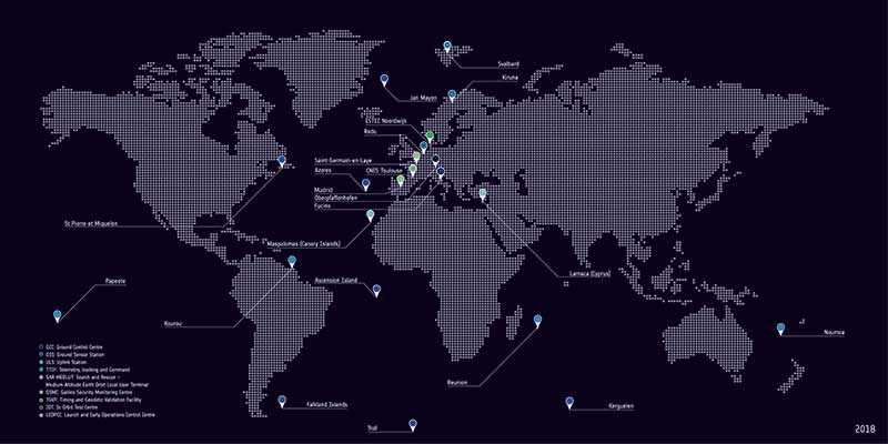
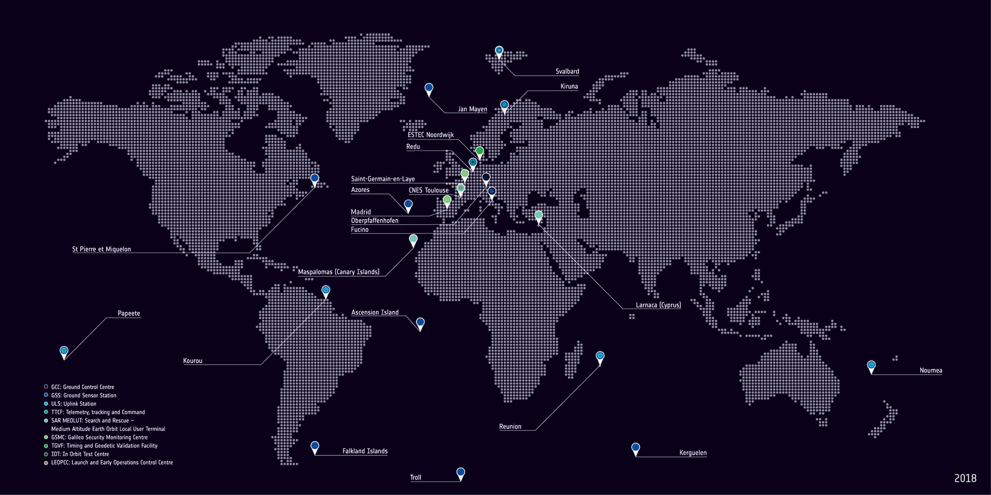
Galileo’s global ground segment. (Photo: ESA)
According to ESA, a major driver of this latest update was the growth of the Galileo constellation, which increased by 12 satellites through a trio of Ariane 5 launches in the last three years to become Europe’s largest.
The updated ground system incorporates a sixth telemetry, tracking and control station in Papeete, used to oversee Galileo satellite platforms, as well as an expansion of the number of antennas at the sites of uplink stations at Kourou in French Guiana, Reunion Island in the Indian Ocean and Noumea in French Polynesia.
In addition, receivers have been added to the Galileo sensor stations to ensure full redundancy.
“This marks the first update for Galileo’s operational infrastructure since it entered service,” said Edward Breeuwer, ESA Galileo system test and verification manager. “Galileo Initial Services began in December 2016, then last year we passed control of the system to our partner organization, the European Global Navigation Satellite System Agency, or GSA.
“This, therefore, marks a major step, but migration to the upgraded system should in principle be entirely transparent to Galileo users. We achieve this by taking advantage of the redundant elements of the Galileo system, taking them offline to update them while their operational counterparts continue to run.”
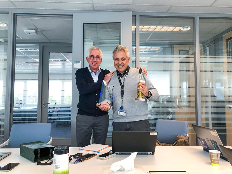
Javier Benedicto (left) and Giuliano Gatti. (Photo: ESA)
Javier Benedicto, head of the Galileo Programme and Navigation-related Activities at the European Space Agency, accepted the 2018 Satellites Leadership Award and delivered these remarks on behalf of Giuliano Gatti at the 2018 GPS World Leadership Awards Ceremony. Gatti, the space segment procurement manager at the European Space Agency, received the award for his contribution to setting up the Galileo constellation from GIOVE-A and -B precursors through all Galileo operational satellites: Soyuz and Ariane 5 launches, a total of 26 Galileo satellites deployed in 7 years.
On behalf of Giuliano Gatti, I express his gratitude for this award.
After a 20-year career in microwave equipment for satellite application, working in Italy, Canada and the Netherlands, Mr. Gatti started working on navigation satellites at end of the 1990s as ESA Galileo Space Segment Manager.
He went through the initial difficulties of the program, namely the uncertainty on financing and the technical lack of maturity of critical units such as atomic clocks. At the time, joining the Galileo team of the European Space Agency was risky and challenging.
In spite of these issues, he was a key player in the developments of the first two Galileo experimental satellites, GIOVE-A and GIOVE-B, and he was in charge of their launches in 2005 and 2008, respectively, on Soyuz rockets from Baikonour, Kazakhstan.
He then followed the development and launch of the 4 IOV satellites, two in 2011 and two in 2012, from the European space port in French Guyana, on a Europeanized version of the Soyuz rockets. The first IOV launch was actually the first launch with this version of the launcher, and interface and schedule coordination issues were challenging tasks for him.
He then was instrumental for the procurement of the following generation of satellites, the 22 FOC satellites. He struggled to make sure that satellites would be produced and launched in line with the program deployment plan. Another challenge in this phase was ensuring that the adaptation of the Ariane-5 ES rocket to the Galileo satellites would converge in time and comply with all technical requirements.
Under his guidance and responsibility, the 22 satellites were put in orbit with 5 Soyuz launches and 3 Ariane-5 launches. Here the most difficult event was the launch that put two Galileo satellites in the wrong orbit, and the subsequent recovery of the satellite mission. In addition, a number of failures affected some of the in-orbit atomic clocks, and hedrove the investigation that led to the discovery of the root causes and their resolution.
Mr. Gatti then initiated the procurement and production of the follow-up recurring satellites, the so-called Batch-3 satellites. These 12 satellites have stringent schedule requirements and their first launch is planned for late 2020 or early 2021.
In parallel, he contributed to the definition of the next generation of satellites, the Transition Satellites: heavier spacecraft with improved performance and high level of re-configurability and flexibility. They will be the first step moving from the existing first generation of satellites to the second generation. In this phase, his experience and competence have played a fundamental role to arrive at the definition of the appropriate procurement requirements.
After 20 years on the development and deployment of Galileo, being in charge of the launches of 28 satellites, from the first GIOVE-A satellite in 2005 to the launch of the last 4 FOC satellites in July 2018, Mr Gatti will retire in mid-2019.
He is delighted and honored that all his efforts and contributions to develop and launch the Galileo constellation have been recognized in this important GNSS event.
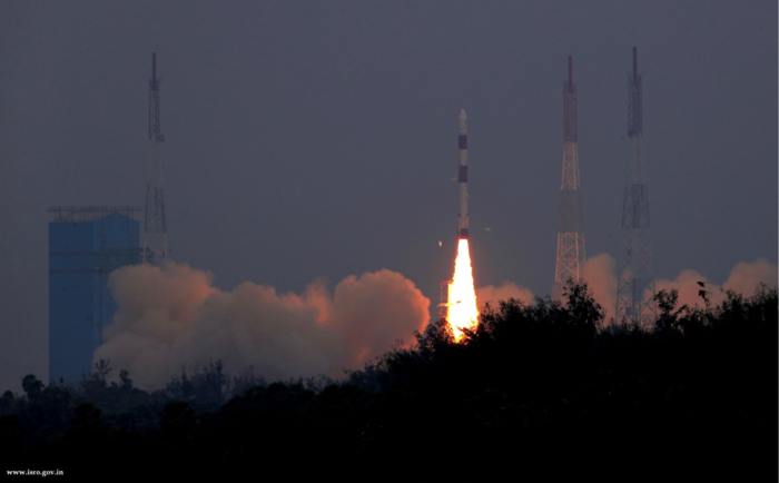
Two tiny GNSS-RO nanosatellites now circle the Earth, ready for action. The first European Pioneer mission lifted off Nov. 29 from Sriharikota, India, to put the satellites into orbit.
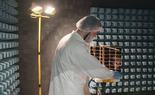
One of Spire’s Satellite Manufacturing Technicians (Tomasz Chanusiak) tests the Radio Frequency capabilities of a LEMUR2 nanosatellite in Spire’s cleanroom in Glasgow, Scotland. (Photo: ESA)
The shoebox-sized satellites were launched at 04:27 GMT into low Earth orbit by the Indian Space Research Organisation’s PLSV launcher, and opened their first communication windows with their owner, Spire Global, less than an hour after they separated from the rocket.
Both satellites were developed under ESA’s ARTES Pioneer programme, and will aim to prove the value of using nanosats for space-based GNSS Radio Occultation (GNSS-RO).
GNSS-RO. GNSS-RO is the process of using satellites to measure how GNSS signals are refracted by the Earth’s atmosphere. Experts can use these measurements to glean temperature, pressure and humidity information for weather forecasting and climate change monitoring.
In contrast, weather data gathered by weather balloons and aircraft can only reach certain altitudes, leaving the higher atmospheric layers untouched.
Satellites have no such restrictions. They can gather massive amounts of this data from the ground up to the mesosphere as they fly over the Earth. This is usually done by large satellites. Spire’s nanosatellites weigh just 5 kg each, and were assembled and tested entirely by Spire in under three months, at their headquarters in Glasgow, Scotland.
Named “Space as a Service,” the Spire Pioneer mission intends to prove that nanosat GNSS-RO is a commercially viable alternative to traditional methods.
Two nanosatellites built by Spire Global were launched into low Earth orbit Nov. 29. (Photo: ISRO)
The two tiny satellites will collect and distribute GNSS-RO data during their commissioning phase, after which they will go into full commercial data production mode, gathering weather information for meteorological institutions, maritime and aviation customers on demand.
ESA’s Pioneer initiative partners with companies like Spire to help them provide this kind of in-orbit demonstration and validation for third parties.
“We saw a gap in the market for what we call space mission providers: companies that offer all aspects of a space mission to validate a new technology or service for the benefit of others,” said ESA Pioneer Programme Manager Khalil Kably. “ESA is always looking to champion innovation in the space industry, and the idea of Pioneer is that these space mission providers can help this by being a one-stop shop for in-orbit demonstration and therefore reduce the barriers and complexity that can stifle new ideas.”
“Spire has been focused on developing unique data sources with high frequency updates for the entire Earth and has over 60 LEMUR-2 class satellites deployed in space complimented with a global ground station network,” Spire Global CEO Peter Platzer said. “Under Pioneer, we can offer our extensive experience in manufacturing and managing small spacecraft like these to those who cannot afford to waste money and time doing it themselves. This work with ESA helps further support the global development of commercial aerospace’s potential to make space access universal.”
“These incredibly clever shoebox-sized satellites built in Glasgow could slash the complexity and cost of access to space, presenting an exciting opportunity for the UK to thrive in the commercial space age,” UK Space Agency Chief Executive Graham Turnock said. “Through our £4m development funding, the government’s Industrial Strategy and by working closely with our international partners, we are helping UK businesses transform their ideas into commercial realities, resulting in jobs, growth and innovation.”
Global satellite navigation systems are continuously bathing Earth in satnav signals. As well as helping in our daily lives, these signals are also tools for cutting-edge science. A new ESA facility, based at ESA’s astronomy centre near Madrid, is championing their use for everything from Earth monitoring to fundamental physics.
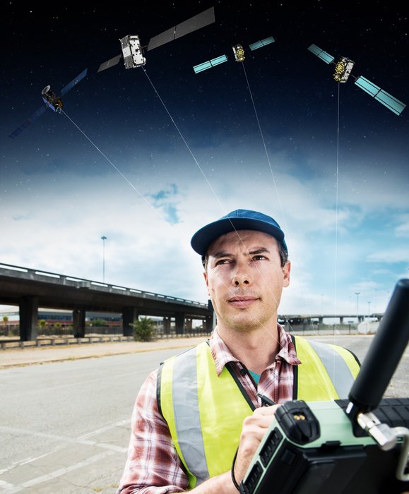
A Surveyor uses a GNSS device to map urban assets with Galileo and EGNOS. (Image: ESA)
The new ESA Global Navigation Satellite Systems (GNSS) Science Support Centre is based at ESA’s European Space Astronomy Centre, ESAC, near Madrid. Run by ESA’s Galileo Science Office, the GSSC integrates IT and satnav infrastructure to deliver advanced data processing services to the scientific community.
Precisely timed to a few billionths of a second and highly stable, satnav signals can be used as a point of reference for many scientific sectors, including Earth and atmospheric sciences, astronomy, highly precise timing metrology as well as the study of relativity and other fundamental physics topics.
Current satnav infrastructure plans worldwide should see more than 120 satnav satellites in orbit in coming years. This number includes Europe’s own Galileo constellation — offering unique features such as its highly stable passive hydrogen maser atomic clocks, multiple transmission frequencies, robust modulation, wide bandwidth and onboard laser retro-reflectors, which permit exact pinpointing of the satellites’ position in space down to a few tens of centimetres.
“The potential of satnav for science has been recognised for a long time,” explains Javier Ventura-Traveset, Head of ESA’s Galileo Science Office. “The Galileo Science Office was set up in 2016 as a joint initiative between ESA’s Science and Navigation Directorates, coordinating scientific opportunities through interaction with the scientific community and the independent GNSS Science Advisory Committee.
“The opening of the new centre is the next step. It is ESA’s concrete answer to the need expressed by the scientific community for a one-stop-shop to offer researchers long-term GNSS data, products information, results of scientific experiments, plus services to enhance GNSS scientific research and collaboration.
“The future evolution of the centre will be driven by the interaction and feedback received from the scientific community, maximizing synergies with other GNSS data service providers from other institutions and research organization.”
Among the activities to be supported by the new GSSC are big data processing of large amounts of satnav data, crowdsourcing as a means of weather monitoring and a scientific assessment of satnav performance in Antarctica.
It also supports the continuing measurements of general relativity using Galileo satellites 5 and 6 and serves as a global data centre for the International GNSS Service. The long-established Navipedia website, giving technical information on satnav, is also hosted by the GSCC.
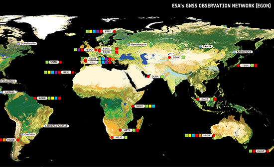
One enthusiastic early adopter is ESA’s Navigation Support Office, based at ESA’s ESOC mission control centre in Darmstadt, Germany, lending support to mission teams making use of satnav to steer satellites.
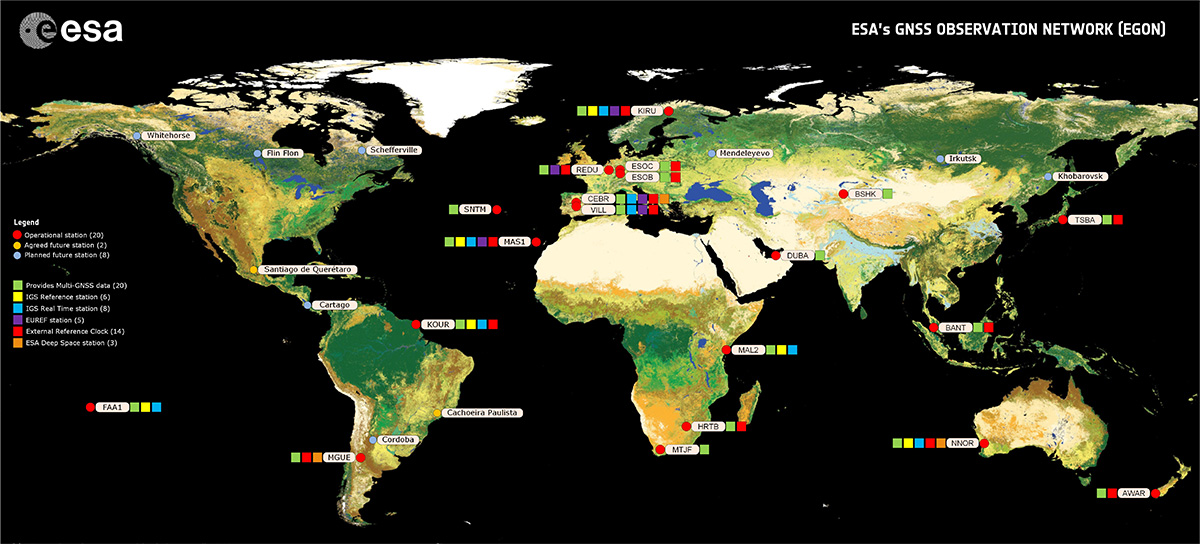
“The GSSC is a welcome addition to ESA’s activities in the science of satellite navigation,” says Werner Enderle, heading ESOC’s Navigation Support Office. “The GSSC already hosts GNSS products generated by the team at ESOC, including observations from our worldwide EGON GNSS Observation Network and precise satellite orbits generated by their state-of-the-art software. Our two teams look forward to this collaboration continuing for the benefit of ESA and the scientific community.”
The GSSC will roll out access to data, products and services over the coming months.
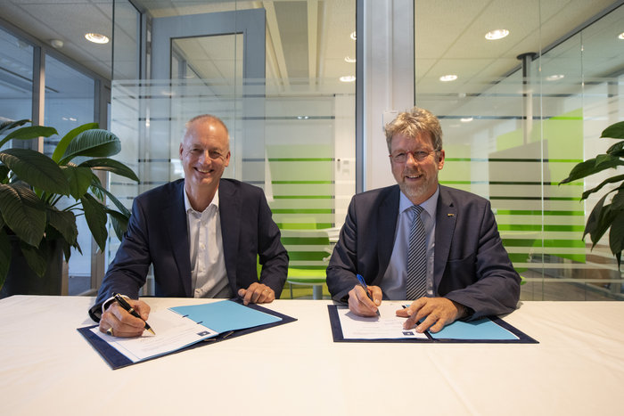
The European Space Agency has awarded a new framework contract and two new work orders to Thales Alenia Space in France to upgrade the Galileo Mission Segment, the element of the worldwide Galileo ground segment dedicated to delivering navigation services. Included are upgrades to the Galileo Security Monitoring Centre (GSMC) near Paris, and implementation of a second GSMC in Spain, near Madrid.
ESA Director of Navigation Paul Verhoef signed the contract with Thales Alenia Space Senior Vice President of Sales Martin van Schaik on Oct. 17 at ESA’s ESTEC technical centre in Noordwijk, the Netherlands.
“Galileo has already proven to be the highest performing satellite navigation system in the world, even before the constellation is complete,” Verhoef said. “This achievement is the result of the close collaboration between the public sector — the European Commission, the European GNSS Agency and ESA — and our industrial partners throughout Europe.
Contract signing: van Schaik (left) and Verhoef. (Photo: ESA)
“Today I am very happy to announce a continued relationship with Thales Alenia Space in one of the most complex parts of the system, namely the Ground Mission Segment, and thank them for their commitment to the programme.”
The constellation in orbit is only one element of the overall satellite navigation system – the tip of the Galileo iceberg. At the same time as the satellites were being built, tested and launched, a global ground segment was put in place.
Complex System
Establishing Galileo’s ground segment was among the most complex developments ever undertaken by ESA, having to fulfil strict levels of performance, security and safety.
In 2017, responsibility for operating the Galileo ground segment was passed to ESA’s partner organization, the European GNSS Agency (GSA). Nevertheless, ESA continues to be in charge of the maintenance, development and evolution of the ground segment, as well as the development of the space segment.
GSMC upgrade and construction. The first work order contracts Thales Alenia Space as prime contractor to undertake all necessary activities to upgrade the Galileo Mission Segment and the GSMC as part of Galileo’s exploitation phase.
This work includes upgrading Galileo’s system architecture to provide more accurate navigation products for broadcast by Galileo satellites, updating obsolescent elements in the current system, and improving operability linked to the provision of services and enhanced robustness.
This work order also includes the construction of additional uplink stations – tasked with uplinking the latest navigation messages to the Galileo constellation — at the existing Galileo ground station sites of Papeete in French Polynesia and Svalbard in Norway.
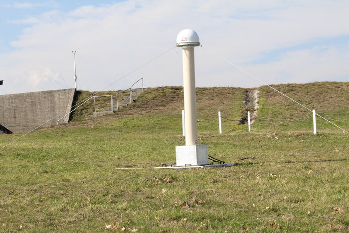
A new sensor station — providing a ground-based measurement of Galileo signal quality and precise satellite position — will also be installed at Wallis Island in the Pacific.
Galileo’s Nouméa ground station’s Sensor Station and Uplink Station. (Photo: ESA)
The work order will also augment the capabilities for implementation of the Public Regulated Service (PRS), the single most accurate and secure class of Galileo signals. Encrypted PRS signals will be made available only to authorised governmental users through approved national authorities.
Together, the two GSMCs will ensure the security of the overall Galileo system and manage PRS access and operations.
Security monitoring. The second work order contracts Thales Alenia Space as prime contractor to implement security monitoring functions for Galileo operational assets — including the control centres, service facilities and ground stations.
The integration, qualification, deployment and migration into operational services of the various upgraded segments will be undertaken over the next three years.
ESA has issued these work orders in its role of undertaking the design and development of future upgrades and the technical development of infrastructure as well as overseeing Galileo’s deployment, on behalf of the European Union, Galileo’s owner.
European students and researchers are invited to compete in a new Galileo smartphone app competition sponsored by the European Space Agency (ESA).
The goal is to develop an app capable of performing fixes using raw Galileo satnav measurements. An earlier Galileo smartphone app competition has already resulted in the winning app becoming publicly available.
This year’s event challenges teams to make use of the dual-frequency capability of the latest Android 8.0 smartphones, to compute dual-frequency positioning solutions from raw satnav signals to compare them with their single frequency equivalents.
The competition is run by ESA in collaboration with the European Global Navigation Satellite Systems Agency (GSA) plus the European Commission with the support of Google.
The Galileo app competition is open to all students from European universities and trainees in posts at European research and development organizations.
“The inaugural Galileo smartphone app competition was open solely to ESA graduate trainees, but the response was so great that this time we have opened up to students and young researchers across Europe, forming teams of three to five people,” explained ESA Galileo Services Engineering Manager Rafael Lucas Rodriguez.
The set objective is to reach sub-meter accuracy worldwide in unobscured sky conditions. The app should allow the user to select Galileo-only positioning, GPS-only positioning and the combination of both on a simultaneous basis, with the potential to include other satnav constellations in turn.
The receiver chipsets inside smartphones routinely make use of Galileo in combination with several other satnav constellations — the U.S .GPS, Russian GLONASS and Chinese BeiDou. These chipsets function in “black box” style, making the resulting positioning fixes accessible to users, but without giving any option to the user to select which constellation to employ — or information on Galileo’s particular contribution to the phone’s overall positioning performance.
However, in newer Android smartphones it has become possible to access the raw signal measurements used to compute position, opening the door to the development of applications where the user can indeed select which constellations to employ.
The very latest models also allow the use of dual satnav frequencies, giving a major boost to positioning precision. The higher chip rate of the additional frequency allows the chipset to compensate for signal propagation errors from the signals’ journey through the ionosphere — the electrically active outer layer of atmosphere — and reduces false ‘multipath’ detections caused by signals reflecting off buildings.
“As a first step, teams submit a proposal of not longer than 20 pages, summarizing the application to be developed,” explained ESA navigation engineer Nityaporn Sirikan. “These proposals will be evaluated by a jury composed of representatives of ESA, GSA, the EC and Google, with the top five proposals selected to develop their app further, receiving on loan a state-of-the-art dual frequency satnav smartphone and receiving general guidance and technical support.”
The competition launched on Sept. 24; teams are invited to submit their proposals to [email protected] by Nov. 12, and will be informed of the jury’s response to their proposal by Nov. 26. The competition final is scheduled for April 18, 2019, at ESA’s ESTEC technical centre in Noordwijk, the Netherlands. Terms and conditions of the competition are posted here.
The first- and second prize-winning teams will win attendance to the ESA and EC International Summer School on Global Navigation Satellite Systems in Portugal. Additional prizes will be available to the most innovative app and the winner of a public online vote, to be undertaken during the final.
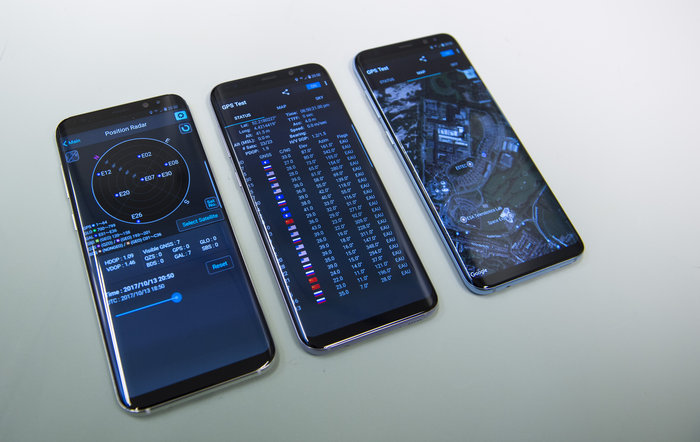
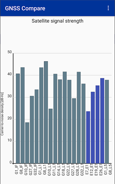
Taking advantage of the recent release of Android API 24 and the GnssMeasurement class, developers now have access to unprocessed pseudorange measurements in certain smartphones.
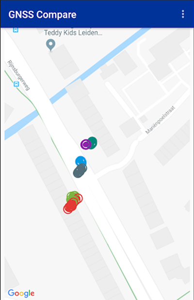
GNSS Compare is basically a tool for scientists to compare their algorithms. For those who are not GNSS experts, it can also serve as a teaching tool on the subject.
The Galileo Smartphone App Challenge was about creating a smartphone application that will allow the user to choose which satellite constellation to use for PVT estimation.
Screenshot: TFI Systems
The aim was to increase the awareness about the European Union’s Galileo satellite navigation program and also to allow users from the public to compare the performance of Galileo signals with the performance from other global satellite navigation constellations.
The app has been tested on Samsung Galaxy S8 and Xiaomi Mi 8 phones. To download, visit the store.
With Europe’s Galileo constellation in space now expanded to 26 navigation satellites — and Galileo Initial Services available to users worldwide — the infrastructure on the ground that controls them is undergoing a corresponding expansion.
ESA has awarded a new work order for the Galileo Control Segment — that part of the Galileo system responsible for the monitoring and control of all the satellites in orbit — to GMV Aerospace and Defence, Spain.
The contract was signed by ESA Director of Navigation Paul Verhoef and Jesús B. Serrano Martínez, CEO of GMV, in a ceremony hosted at Spain’s Ministry of Science, Innovation and Universities in Madrid, in the presence of Spanish Science Minister and former ESA astronaut Pedro Duque.
The ground control contract was signed Sept. 6 at at Spain’s Ministry of Science, Innovation and Universities in Madrid. From left: Verhoef; Secretary General of Transport of Spain’s Ministry of Public Works, María José Rallo, representing Spain in the EU Committee on Satellite Navigation Programmes; Spanish Science Minister and former ESA astronaut Pedro Duque; European Commission adviser on navigation activities Augusto González; and Martínez. (Photo: ESA)
Galileo’s Control Segment is hosted at the Oberpfaffenhofen Control Centre in Germany, with a “hot backup” in place at Galileo’s second Control Centre, at Fucino in Italy. It also extends to a network of Telemetry, Tracking and Control (TT&C) ground stations placed around the globe to stay linked with all satellites in the constellation.
The combination of these Control Centres plus TT&C stations are vital to keep Galileo running at its highest possible performance level. They monitor the overall status of the constellation, gather telemetry and uplink telecommands to each satellite, while also performing two-way radio and Doppler ranging to keep precise track of their position in space, identifying any orbital drift that might degrade the system’s accuracy.
The Galileo Control Segment has been designed to allow the automatic execution of routine operations. It also includes elements supporting flight dynamics analyses, constellation operations short-term planning as well as operations preparation.
Galileo’s global ground segment. (Map: ESA)
This first work order for the “Galileo Control Segment Exploitation Phase” contracts GMV Aerospace and Defence as prime contractor to undertake all necessary activities to upgrade the Galileo Control Segment as part of Galileo’s Exploitation phase.
This work includes upgrading the system architecture to manage a constellation of up to 41 Galileo satellites, updating obsolescent elements in the current system, improving operability linked to the provision of services and the addition of a new, second TT&C station to be based in Kourou, French Guiana.
The integration, qualification, deployment and migration into operational service of the various segments of the upgraded Galileo Control Segment will be undertaken over the next three years.
The Galileo ground station near New Caledonia capital Nouméa incorporates a Galileo Sensor Station (foreground) that monitors the quality of navigation signals and an uplink station (background) to relay navigation corrections to the satellites for rebroadcast to users. An antenna 13 meters in diameter for controlling the satellites has also been built, ready to come online later this year. (Photo: ESA)
This process is to undertaken while maintaining coherence with the other segments of the overall Galileo system – such as the Galileo Mission Segment which oversees Galileo services, the external control centres that carry out initial satellite switch-ons and in-orbit testing and the satellite platform and payload manufacturers, OHB System AG in Germany and Surrey Satellite Technology Ltd in the UK.
ESA has issued this work order in its role overseeing Galileo’s deployment, the design and development of future upgrades and the technical development of infrastructure on behalf of the European Commission, Galileo’s owner.
If you’ve taken a flight in Europe recently, then the chances are growing that you’ve been a pioneer EGNOS user. Satellites in orbit would have guided your airliner’s descent, rather than signals beamed from the ground. You wouldn’t have felt any difference — except for possibly a smoother ride.
Cockpit of a new EGNOS-equipped Airbus 350 XWB, on show during the inaugural EGNOS Day at Toulouse-Blagnac Airport on May 7, 2015. (Photo: ESA)
More than 180 European airports have now been certified to make use of the ESA-designed European Geostationary Navigation Overlay Service — EGNOS — for approaches to given runways. This includes approaches at major hubs such as Paris Charles de Gaulle, Frankfurt and Amsterdam Schiphol. Thanks to EGNOS, safe landings would still be possible even if an airport were shut down entirely.
Sharpening the precision of GPS satnav signals over most European territory, EGNOS was designed to make satnav reliable enough for safety-critical aviation employment, but has found a wide range of other uses, from agriculture to road, rail and maritime transport.
An EGNOS app is available from the Apple and Google Play stores, offering easy access to all EGNOS-related information, including the different EGNOS services, official documentation, historical and current performance data, support material and contact with the 24/7 EGNOS helpdesk.
An EGNOS V3 Ranging and Integrity Monitoring Station (RAIMS) being tested at the Santiago de Compostella site in Spain, designed and manufactured by Thales Alenia Space in Italy. (Photo: ESA)
EGNOS is based on a network of monitoring stations across Europe that perform independent measurements of GPS signals, so that corrections can be calculated to boost satnav positioning performance. These results are passed to users immediately via a trio of geostationary satellites.
The service is allowed just a one in 10 million chance of error. If this tolerance is exceeded, EGNOS users are informed within six seconds. The result is that EGNOS-augmented signals meet the extremely high performance standards set out by the International Civil Aviation Authority, adapted for Europe by Eurocontrol, the European Organisation for the Safety of Air Navigation.
EGNOS operations are the responsibility of the European Global Navigation Satellite System Agency (GSA) of the European Commission and run by the ESSP, European Satellite Services Provider.
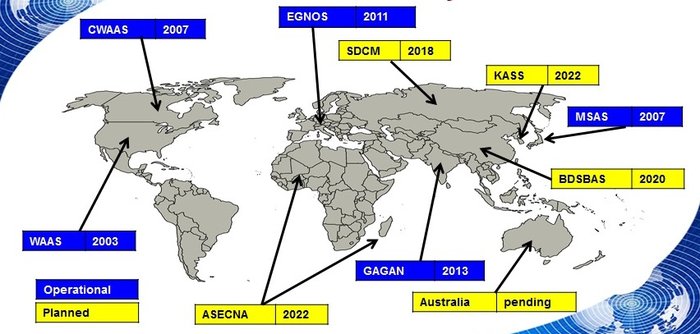
EGNOS is the European equivalent of the U.S. Wide Area Augmentation System (WAAS), which was the world’s first satellite-based augmentation system. The U.S. and European systems have been carefully designed to work together seamlessly.
Additional equivalent regional systems, fully interoperable with the existing ones are either in operation (Japan, India, Canada) or in definition or development (Russia, China, South Korea, West Africa and Australia).
Satellite-based augmentation systems worldwide. (Image: ESA)
Through the LPV-200 procedure, short for “localizer performance with vertical guidance 200 feet,” signals from space guide pilots through any weather down to within just 60 meters (200 feet) of the runway, at which point they make visual contact with the ground for a final go/no go landing decision.
EGNOS offers all-weather access to all certified runway approaches — each side of a runway requiring its own, separate, certification — without the need for expensive ground Instrument Landing System infrastructure. Satellite-based landing approaches can also be tailored to be smoother and more fuel-efficient.
Smaller airports unable to afford ground instrumentation draw the greatest benefit. Employing EGNOS means they get to operate in all weather conditions.
ESA retains the lead role in the future development of EGNOS, working with Thales Alenia Space and Airbus Defence and Space and their subcontractors to design, develop, deploy, and validate and test the new design elements.
While the current system is solely reliant on GPS, the next-generation EGNOS V3 will combine the use of GPS with Europe’s own Galileo satnav system to boost EGNOS accuracy and reliability still further. It is planned to enter service around 2025.
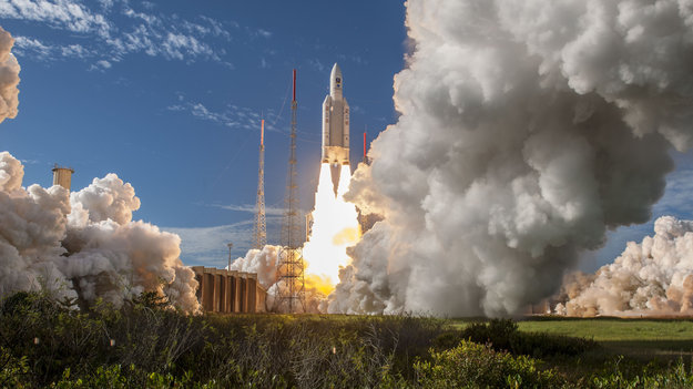
Four more Galileo satellites were launched July 25 by an Ariane 5. Their arrival in orbit brings the Galileo constellation to 26 satellites, extending the global coverage of the constellation.
Ariane 5 flight VA244, operated by Arianespace under contract to ESA, lifted off from Europe’s Spaceport in Kourou, French Guiana, at 11:25 GMT (13:25 CEST, 08:25 local time), carrying Galileo satellites 23–26. The first pair of 715 kg satellites was released almost 3 hours 36 minutes after liftoff, while the second pair separated 20 minutes later.
They were released into their target 22 922 km-altitude orbit by the dispenser atop the Ariane 5 upper stage.
In the coming days, this quartet will be steered into their final working orbits by the French space agency CNES, under contract to the Galileo operator SpaceOpal for the European Global Navigation Satellite System Agency (GSA).
There, they will begin around six months of tests by SpaceOpal to verify their operational readiness so they can join the working Galileo constellation.
“Galileo is ESA’s largest ever satellite constellation, built up to its present size in rapid time, with 22 Full Operational Capability satellites added within just the last four years,” remarked Jan Wörner, ESA’s director general.
“We must thank our industrial partners OHB (DE) and SSTL (GB) for the satellites, as well as Thales Alenia Space (FR/IT) and Airbus Defence and Space (GB/FR) for the ground segment and all their subcontractors throughout Europe for their continued support to the programme. Together with ESA, the entire industrial team has worked hard for the point at which we now are and this cooperation have proven to be very successful, as we can show in the excellent performance of Galileo.”
Paul Verhoef, ESA’s director of navigation, added, “Galileo has been providing Initial Services on a worldwide basis since 15 December 2016, and today has more than 100 million users, and rapidly increasing. Today’s satellites will increase the global coverage of Galileo with a performance that is widely recognized as excellent.
“This is the end of the current phase of Galileo deployment, but our pace is not slacking. A further 12 Galileo ‘Batch 3’ satellites are in preparation as in-orbit spares and as replacements for the oldest Galileo satellites, first launched in 2011, in order to keep the system working seamlessly into the future.
The European Space Agency launched the next four Galileo satellites on an Ariane 5 on Wednesday July 25, at 11:25 GMT (13:25 CEST, 08:25 local time) from Europe’s Spaceport in Kourou, French Guiana.
These latest four Galileo satellites will bring the constellation in orbit up to 26 satellites.
Livestream coverage of the launch starts at 11:00 GMT (13:00 CEST) with liftoff at 11:25 GMT (13:25 CEST).
Live coverage resumes with confirmation of the satellites separating from their upper stage from 14:50 GMT (16:50 CEST).
Separation of the Ariane 5’s upper stage occurs about nine minutes after liftoff, followed by the first 10-minute firing of the upper stage.
The upper stage — carrying four 715-kg Galileo satellites — flies in ballistic configuration for three hours and eight minutes, after which a second upper stage firing lasting just over six minutes will place it into circular separation orbit.
Once stabilized at 3h 36 min after liftoff, the Galileo dispenser will release the first two satellites, followed by the second pair 20 minutes later.
In the meantime, check out ESA’s new Galileo video.
The Ariane 5 carrying Galileo satellites 23-26 is in place at the ZL3 launch site ready for liftoff. (Photo: ESA)