Tag: ESA

  • ESA provides new maps of Earth from reflected satnav

    ESA provides new maps of Earth from reflected satnav

    News from the European Space Agency

    Your phone or satnav receiver routinely picks up signals from navigation satellites in order to tell you precisely where you are. But have you ever thought what happens to those satnav signals afterwards? A foresighted ESA inventor had the idea of using them as a tool for observing the Earth.

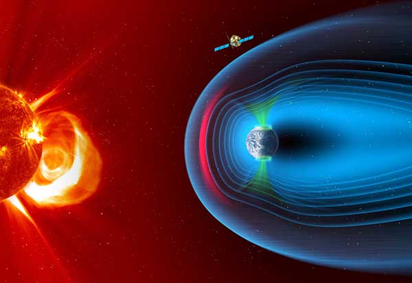
    More than 120 satellite navigation satellites are in orbit, making up multiple constellations including Europe’s Galileo system, sending down a continuous rain of satnav signals for the benefit of users worldwide. Just like visible light, these microwave signals go on to reflect off Earth’s land and sea surfaces.

    The traditional attitude to these reflected signals is to see them as something of a nuisance — known as multipath, they can confuse satnav receivers and reduce their overall accuracy.

    ESA microwave engineer Manuel Martín-Neira, inventor of the PARIS reflectometry concept. (Photo: ESA)
    ESA microwave engineer Manuel Martín-Neira, inventor of the PARIS reflectometry concept. (Photo: ESA)

    But back in 1993 — at the same time as the US GPS satnav system reached its full constellation of 24 satellites — a young ESA microwave engineer called Manuel Martín-Neira came up with the idea of treating these satnav reflections as a scientific resource instead.

    “My head of division asked me to come up with a budget-friendly way of increasing the overall sampling rate to build up a fuller picture of mesoscale phenomena, and that led me to start looking into making use of additional signals of opportunity, chiefly satnav signals.

    “The initial reaction was mixed, because the forecast accuracy was not as precise as the ERS-1 altimeter could deliver — but on the plus side there would be a lot of these signals to make use of, and the performance has improved a lot since those early days.”

    PARIS, detecting reflected satnav. (Photo: ESA)
    PARIS, detecting reflected satnav. (Photo: ESA)

    Inspiration from reflection

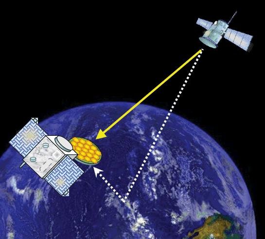
    The basic idea of what Manuel christened the Passive Reflectometry and Interferometry System, or PARIS, comes down to a two-sided antenna. As the topmost side picks up a satnav signal from the satellites in orbit, the other side picks up the version of the signal bounced back from Earth.

    By comparing this initial, overhead signal with its reflected equivalent using a process called interferometry — measuring tiny differences in signal phases – the extra travel time of this reflected beam can be determined, down to an accuracy of less than five centimetres, determining sea height and sea ice thickness.

    Additional amplitude waveform processing can deliver further data on wind and wave measurements over the ocean, and soil moisture and biomass over land.

    Satellite reflectometry has since grown into a thriving field. This summer, Manuel attended the latest international workshop on the method he first devised 26 years ago.

    Reflectometry reaches space

    “It’s been fantastic to have experimental evidence, and that’s really been made possible by the growing availability of smaller satellites,” explains Manuel.

    “Because satellite reflectometry is a passive form of remote sensing, it makes for an attractive potential payload because it doesn’t need a lot of power to operate. Then one of the results is meteorology data that private companies intend to make money with by delivering to public agencies.”

    Surrey Satellite Technology Ltd's UK-DMC satellite was the first orbital mission with a reflectometry payload. (Photo: ESA)
    Surrey Satellite Technology Ltd.’s UK-DMC satellite was the first orbital mission with a reflectometry payload. (Photo: ESA)

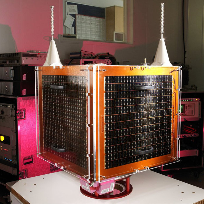
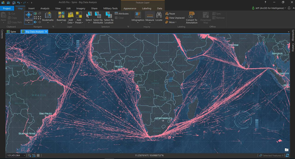
    In 2003, the UK-DMC satellite was the first mission to fly a reflectometry payload, followed in recent years by, for example, the UK’s TechDemoSat-1, NASA’s CyGNSS constellation to monitor hurricanes and the Spire global constellation of commercial nanosatellites.

    “These satellites have really given the reflectometry community a wealth of signals, demonstrating what reflections look like over different surfaces including sea ice, forests, and even inland water bodies such as the Amazon River and its tributaries.

    “In parts of the ocean near continental masses and within atolls we are seeing reflected signals from very calm waters which resembled a mirror, giving us very high precision down to 1 cm level. Such measurements could potentially complement current altimetry missions, by for instance measuring sea level rise.”

    Example of a CYGNSS Microsatellite Observatory. (Image: Southwest Research Institute)
    Example of a CYGNSS Microsatellite Observatory. (Image: Southwest Research Institute)

    ESA activities taking flight

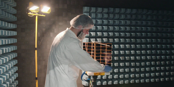
    ESA meanwhile is active on reflectometry in various ways, having developed and tested a steerable airborne antenna called the Software PARIS Interferometric Receiver or SPIR, capable of steering separate antenna beams to build up a rapid surface picture, and differentiating between different signal sources, such as GPS from Galileo.

    Manuel adds: “ESA’s GNSS Science Support Centre, based at the Agency’s European Space Astronomy Centre near Madrid, has been taking a keen interest in these activities.”

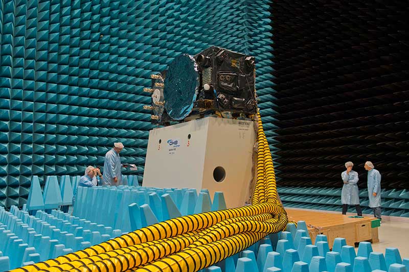
    Missions are also in development, including a dedicated CubeSat with RUAG-Austria and the University of Graz called PRETTY (for Passive REflecTomeTry and dosimetry, which would also carry a radiation detector), and a small satellite pair called FSSCat from Spain’s Universitat Politècnica de Catalunya, backed through the Copernicus Masters competition, seen as a prototype for a future reflectometry constellation.

    ESA’s Directorate of Telecommunications and Integrated Applications is also working with the Spire company to fly enhanced reflectometry instruments, starting at the end of this year.

    One of Spire's Satellite Manufacturing Technicians (Tomasz Chanusiak) tests the Radio Frequency capabilities of a LEMUR2 nanosatellite in Spire's cleanroom in Glasgow, Scotland. (Photo: ESA)
    One of Spire’s Satellite Manufacturing Technicians (Tomasz Chanusiak) tests the Radio Frequency capabilities of a LEMUR2 nanosatellite in Spire’s cleanroom in Glasgow, Scotland. (Photo: ESA)

    When it comes to the thriving state of today’s reflectometry community, Manuel recalls the patenting of his idea as a turning point: ‘Having had this idea, which was not particularly well received, the proposal by ESA’s Patents Group to patent it made all the difference. It gave me a feeling of confidence, that somebody else at least saw the potential of this idea — and the rest is history.”

  • Europe chooses Airbus for SMILE space weather satellite

    Europe chooses Airbus for SMILE space weather satellite

    Image: European Space Agency
    Image: European Space Agency

    The European Space Agency has chosen Airbus to build the European component of the SMILE (Solar wind Magnetosphere Ionosphere Link Explorer) satellite.

    SMILE will be the first joint satellite mission between the European Space Agency (ESA) and the Chinese Academy of Sciences (CAS), following on from the success of the Double Star/Tan Ce mission which flew between 2003 and 2008.

    The objective of SMILE is to study and understand space weather. Specifically, it will look at the physics behind continuous interaction between particles in the solar wind and Earth’s magnetosphere, the magnetic shield that protects the existence of life in our planet.

    Space weather can interfere with GNSS signals.

    The mission is now entering a four-year period of manufacturing, testing and integration of the payload module and the platform. In launch configuration, these two components will form a 3.15-meter-high stack.

    The spacecraft will have a mass of 2,200 kg and will travel in a highly elliptical orbit around the Earth. Its perigee will be at a distance of 5,000 km (from where it will download data to the Troll ground station in Antarctica and the CAS ground station in Sanya, China), while the apogee will be as far as 121,000 km (almost one third the distance to the Moon). At this vantage point the satellite will have a prolonged view of the Earth’s northern polar regions, to enable the boundary of the Earth’s magnetic field and the Northern Lights, or aurora borealis, to be imaged.

    Payload in Madrid, platform in Shanghai. The payload module will be built at the Airbus site in Madrid, where the instruments will be integrated. The platform will be built in Shanghai. Both, the payload module and the platform will be integrated and tested at ESA’s European Space Research and Technology Centre facilities by a multinational team.

    The science payload consists of four instruments:

    • The Soft X-ray Imager will obtain unique measurements of the regions where the solar wind impacts the magnetosphere.
    • The Ultra-Violet Imager will study the global distribution of the auroras.
    • The Light Ion Analyser will measure the energetic particles in the solar wind.
    • The Magnetometer will assess changes in the local magnetic field.

    “Today, we are able to predict the weather on Earth; now it’s SMILE’s turn to help us understand space weather around the Earth and who knows? Probably one day, we will have enough data to be able to forecast dangerous solar storms that could disrupt our systems in space and on the ground,” said Fernando Varela, head of Airbus Space Systems in Spain. “We thank the Spanish Administration for their decisive and continued support to scientific missions.”

    Other ESA missions, built by Airbus, such as Cluster that studied the Earth’s magnetosphere, and SOHO that studied the Sun, have already improved understanding of space weather.

    Under the current plans, the spacecraft will be launched by a European Vega-C or Ariane 62 rocket in 2023.

  • Dual-frequency Galileo app winners prove power of two

    Dual-frequency Galileo app winners prove power of two

    To test the accuracy of the competing satnav smartphone apps, the words ESA and Galileo were traced along ESTEC's football field. The left side uses single frequency GPS and Galileo signals, the centre uses dual frequency signals from the two constellations while the right is with precise corrections. The word "ESA" is 15 meters high, while "Galileo" is 7 meters high. (Photos: ESA)
    To test the accuracy of the competing satnav smartphone apps, the words ESA and Galileo were traced along ESTEC’s football field. The left side uses single-frequency GPS and Galileo signals, the center uses dual-frequency signals from the two constellations while the right is with precise corrections. The word “ESA” is 15 meters high, while “Galileo” is 7 meters high. (Photos: ESA)

    News from the European Space Agency

    Europe’s students and young researchers were challenged to design a smartphone app to take advantage of Galileo’s dual-frequency signals. The winning entries should soon be available to the public.

    Run by ESA in collaboration with the European Global Navigation Satellite Systems Agency — GSA — plus the European Commission with the support of Google, a total of five teams made it to the final, which took place at ESA’s ESTEC technical heart in the Netherlands.

    Following on from last year’s inaugural competition — which has already resulted in the winning app becoming publicly available — this year’s event challenged teams to make use of the dual-frequency capability of the latest smartphones running Android 8.0, including and computing dual-frequency positioning solutions from satnav signals to compare them with their single frequency equivalents. The competition slogan was “Galileo give mE5,” referring to Galileo’s dual E1 and E5 frequencies.

    “Galileo give mE5”

    The objective of the competition was to reach meter accuracy or less worldwide in unobscured sky, while allowing the user to select Galileo-only positioning, GPS-only positioning and the combination of both on a simultaneous basis, with the potential to include other satnav constellations in turn.

    The winner was selected based on technical checks and a jury’s vote. Separate awards were also given to the most innovative app and the winner of a public vote.

    The multinational O ThiSaVRoS team — named after the Greek word for treasure — developed the “GNSS Android-based Dual Frequency Iono-estimating Precise Point Positioning” or GADIP3 app.

    The multinational ‘O ThiSaVRoS’ team – named after the Greek word for treasure – developed the ‘GNSS Android-based Dual Frequency Iono-estimating Precise Point Positioning’ or GADIP 3 app, winning the ESA-EC-GSA Galileo smartphone app competition 2019. (Photo: ESA)
    The multinational ‘O ThiSaVRoS’ team – named after the Greek word for treasure – developed the ‘GNSS Android-based Dual Frequency Iono-estimating Precise Point Positioning’ or GADIP 3 app, winning the ESA-EC-GSA Galileo smartphone app competition 2019. (Photo: ESA)

    Winners

    The app allows users to perform reliable positioning fixes in real time — selecting which constellations to employ and a choice of single or dual frequency signals — while advanced users can modify the way the positioning is performed, and log all available data for follow-up analysis.

    “Our mission goal is to provide precise positioning to everyone,” explained team coordinator Lotfi Massarweh. The O ThiSaVRoS team performed analysis on more than 120 hours of data from stationary, pedestrian and mobile testing to come up with a pre-processing approach involving rejection of signals from low elevation and under a specific signal-to-noise ratio.

    The five-person team hail from China, Greece, Italy and Spain, studying at Portugal’s Instituto Superior Técnico Lisboa, Delft University of Technology in the Netherlands, Germany’s Leibniz Universität Hannover and the Universities of Bath and Nottingham in the UK. They worked remotely to develop and test the app over the previous six months.

    NavGate allows geo-tagging in augmented reality

    The NavGate smartphone app allows the sharing of geo-tags in augmented reality via the phone's camera, as well as on maps. (Image: ESA)
    The NavGate smartphone app allows the sharing of geo-tags in augmented reality via the phone’s camera, as well as on maps. (Image: ESA)

    As their app’s name suggests, O ThiSaVRoS hope to achieve precise point positioning in future, made possible by dual-frequency signal availability, to come close to single-metre-scale precision.

    Second place went to the ESTEC-based Team GNSS Tonic’s NavGate app — aimed at bringing people together socially to interesting locations. Users can tag sites of interest to be seen by other people, with the resulting geotags viewable for others either on a map or else directly in augmented reality through their phone’s camera. NavGate could potentially be used for everything from sharing dining recommendations to fishing spots, or meeting up with people during an evening out.

    The third prize to the Step with GNSS app by the Romania-based Space Walkers Team, designed to gather data on the paths of users walking outdoors. This game based app is backed up by a server application collecting data from the app users and analysing GNSS performance worldwide or regionally.

    Single versus dual frequency

    The winner of both the public vote and the most innovative app award went to Universitat Autònoma de Barcelona’s Inari Team and their Inari app.

    Inari allows users to select various positioning modes or customise their own, selecting which algorithms and which corrections should be employed as well as specifying constellations and signal frequency. The app can also highlight jamming or spoofing that might be influencing the positioning accuracy.

    ESA’s technical evaluation team performed tests of the competing apps in the days running up to the final, including tracing out ESA GALILEO as accurately as possible across the establishment’s football field.

    The speaker of the jury, Frank van Diggelen from Google, congratulated the teams on their efforts. “Dual frequency on smartphones is a quite new development, and you really are pioneers in this. The manufacturers are still trying to get things right, and you’re helping them do that bit better. Doing anything for the first time is hard but it’s good to be first, so congratulations for that,” he said.

    Galileo smartphone app competition final

    The receiver chipsets inside smartphones routinely make use of Galileo in combination with several other satnav constellations — the U.S. GPS, Russian Glonass and Chinese BeiDou. These chipsets function in ‘black box’ style, making the resulting positioning fixes accessible to users, but without giving any option to the user to select which constellation to employ — or information on Galileo’s particular contribution to the phone’s overall positioning performance.

    However, in newer Android smartphones it has become possible to access the raw signal measurements used to compute position, opening the door to the development of applications where the user can indeed select which constellations to employ.

    The very latest models also allow the use of dual satnav frequencies, giving a major boost to positioning precision. The higher chip rate of the additional frequency allows the chipset to compensate for signal propagation errors from the signals’ journey through the ionosphere — the electrically active outer layer of atmosphere — and reduces false ‘multipath’ detections caused by signals reflecting off buildings.

    The top three teams have won attendance to the ESA & EC International Summer School on Global Navigation Satellite Systems in Portugal.

  • ESA focuses on PNT vs GNSS, wants proposals

    ESA focuses on PNT vs GNSS, wants proposals

    Logo: ESA

    OK, perhaps the headline is a tad misleading. But in addition to its natural preoccupation with Galileo, the European Space Agency (ESA) has begun thinking and talking about PNT as a service and user needs. In 2018, the European Commission issued a memo saying that GNSS alone was not sufficient for many critical and fail-safe operations.

    ESA is now seriously considering how Galileo and other systems can provide users the PNT services and resilience they need, regardless of whether the signals come from space.

    They have also issued a permanent Request for Proposals in this area. From their website:

    The goal is to maintain and improve the capability and competitiveness of the industry of the participating States in the global market for Satellite Navigation, and more broadly PNT technologies and services. In this context, the wider ambition towards the overall PNT sector is justified by the necessity to facilitate cross-fertilisation between space-based and terrestrial positioning technologies.

    This programmatic action will ensure the readiness of the industry to effectively respond to emerging market opportunities by focusing its activities on products ready for the commercial or institutional market.

    The development of ad hoc technologies and product development activities along the whole Satellite Navigation value chain and more broadly PNT products can be proposed by industry to develop products aligned with their plans for future exploitation.

    Activities therefore shall have been identified by industry as having clear potential for being applied in the area of PNT. The activities may address completely new products of a disruptive nature, may be an upgrading or improvement of an existing product or may address a continuation of an activity funded in another framework within another European institutional programme, a national programme or an industrial/academic research programme. The activities shall aim at resulting in a product ready for commercial exploitation.

    Implemented through a continuous open call capable of stimulating unsolicited proposals, the eligibility of which will be indicated by the relevant participating State (i.e. support letter). The pre-commercial nature of this programme element will call for a co-funding approach to be envisaged.

    Proposals must be from companies in the EU states of AT, CA, CH, CZ, DK, ES, FR, FI, UK, IT, IE, NO, NL, PL, PT, RO, SE and DE.

    Proposers must first establish a ESA-STAR/EMITS username and password. More information can be found here.


    Dana A. Goward is the president of the Resilient Navigation and Timing Foundation, and is a regular contributor to GPS World.

  • Anti-jam, anti-spoof readied for European market

    New initiatives from the Navigation Innovation and Support Programme (NAVISP), a program of the European Space Agency (ESA), have targeted counter-jamming and counter-spoofing efforts, as Europe’s Galileo program gains progressive foothold in the marketplace, particularly in safety-critical systems such as driverless cars.

    “We are looking for new and disruptive ideas in navigation and that is why we created NAVISP,” said ESA Director General Jan Wörner.

    TeleConsult Austria is working with JH Joanneum University of Applied Sciences on the GNSS Interference Detection and Analysis System (GIDAS), to automatically detect, classify and pinpoint all intentional interference sources within a given area by monitoring all civil GNSS signals in real time.The aim is to build a multi-frequency scalable system. GIDAS plans to begin commercialization at the end of 2019.

    France Developpement Conseil has developed a hardened satnav module called DRACONAV, combining hardware and software to combat jamming and spoofing. Targeting intelligent transport applications, it seeks to identify cyber attacks and continue to provide authenticated positioning information as they occur.

    DRACONAV would deliver a level of confidence to let users know if they can continue relying on the data the module delivers, and yield an estimate of the receiver’s true position as the attack continues. A prototype design has undergone more than 3,000 kilometers of field tests and is moving to industrialization.

    Intecs Solutions of Italy has created G-Passion, using a software-defined radi

    o to analyze a few tens or hundreds of milliseconds of Galileo signals at a time, to tell the user whether or not the signal is authentic or spoofed.
    In Romania, InSpace Engineering’ MARGOT assesses the multipath and interference impact on PNT information in maritime environments.

    The Norwegian company SINTEF is developing its Advanced Radio Frequency Interference Detection, Alerting and Analysis System (ARFIDAAS) project, offering as wide a spectral coverage as possible — including all current GPS, Galileo and GLONASS signals — to identify disruptions due to intentional or unintentional interference.

    UK company Helix Technologies has developed compact helical antennas, built around a dielectric ceramic core, primarily for driverless cars. The multi-frequency design aims to reduce susceptibility to interference as well as multipath. Testing will soon get underway in several European cities.

  • Galileo constellation represents Europe’s altruistic values

    Galileo constellation represents Europe’s altruistic values

    Headshot: Alan Cameron
    Alan Cameron

    In February I had the privilege of addressing the European Space Agency’s (ESA’s) Navigation Days conference in the Netherlands. An internal ESA event, Navigation Days gathers engineering staff from centers in several countries to discuss the present and future of their endeavors.

    Since most of the audience had been “bathing” in Galileo, EGNOS and the evolution of both systems for many years, the Director of Navigation and the Galileo Project Manager thought it would be interesting for all to have an “outsider” perspective and opinions on Galileo and the European GNSS position in the world.

    Though my half-hour talk ranged freely, and perhaps somewhat wildly, across many sectors and subjects, it had two main foci: the fundamental differences between Galileo and the three other GNSS, and the future portended by those differences. A future column here will address the latter, that is, the future. At present, the present distinctions.

    To me, they distill down to three elements: active stimulus of market development, well-funded research into new applications, and — actually the foundation stone of the afore two — democratically elected governments representing citizenry with altruistic values: a strong desire for the common good, thoughtful regulation, intertwined diversity and open borders.

    In sum, Galileo’s strength is the strength of the European Union.


    “Active stimulus of market development,
    well-funded research into new applications,
    and citizenry with altruistic values.”


    For example, the Horizon 2020 framework program offers €80 billion to support and foster research from 2014–2020. Three E-GNSS calls in H2020 have a total budget of €100.9 million and they synergize with topics on societal challenges. To my knowledge, the U.S. has nothing like this in terms of downstream R&D programs; it is left to the marketplace to initiate and sustain such efforts.This corresponds to the respective economic systems of the two political entities. West of the Atlantic has historically taken a laissez-faire attitude towards applications, development and societal challenges: let the marketplace act.

    The other two GNSS powers, Russia and China, as authoritarian regimes, may build viable GNSS and mandate their use, but the synergy between government and users is lacking. This missing link could prove an economic as well as technical weakness in the future. In some respects, it already has.

    Particularly in transportation, freight and liability-critical applications, where the European GNSS have devoted extensive forethought to both user and societal needs (read “the environment”), we may see a distinctly different and more progressive future unfolding in Western Europe, led by Galileo.

    On the other hand, in the realm of pure consumer devices, the market may be a stronger driver, and U.S. products and services with a GPS bent may remain dominant.

    The Public Regulated Service (PRS) for defense, security, emergencies and critical infrastructure, is the hidden strength of Galileo.

    I’ve run out of space here for non-scientific speculations, but will expand them in a future column or online.

  • ESA to livestream Galileo app awards

    ESA to livestream Galileo app awards

    Xiaomi Mi 8 dual frequency smartphones procured for teams participating in ESA's second Galileo App Competition, taking place at ESTEC in the Netherlands on April 18. (Photo: ESA)
    Xiaomi Mi 8 dual-frequency smartphones procured for teams participating in ESA’s second Galileo App Competition, taking place at ESTEC in the Netherlands on April 18. (Photo: ESA)

    The final presentations of ESA’s second Galileo smartphone app competition will take place April 18. The public is invited to watch the awards ceremony via livestream.

    The competition’s goal is to develop an app capable of performing fixes using raw Galileo satnav measurements. Members of the public can also vote for their favorite app.

    Five teams are competing this year. The competition is run by the European Space Agency (ESA)

    in collaboration with the European Global Navigation Satellite Systems Agency (GSA) plus the European Commission with the support of Google. It was open to all students from European universities and trainees in posts at European research and development organisations.

    Follow Thursday’s event from 09:00 to 16:00 CEST on Livestream at https://livestream.com/ESA/GalileoAppCompetition2019.

  • Copernicus Masters 2019 submissions now open

    The Copernicus Masters competition awards applications and solutions that use Copernicus data to tackle important challenges. Submissions for the 2019 awards opened on April 1.

    The demand for Earth observation (EO) data is exploding in order to find innovative solutions for today’s challenges such as climate change, food security or water supply.

    With more than 15 terabytes of free EO data generated by the Copernicus programme every day, the Copernicus services deliver near-real-time data on a global level — contributing towards the sustainable management of the environment.

    Simultaneously, the Earth observation industry is constantly growing. New data platforms are being developed to receive and process the huge amount of satellite data collected from the Sentinels — and other contributing commissions.

    These data platforms are established on the cloud and work with Artificial Intelligence (AI) and Machine Learning, enabling the development of new applications in the EO sector.

    The Copernicus Masters 2019 — Europe’s leading innovation competition for Earth observation (EO) — is searching for such outstanding applications, solutions, and business concepts from future-oriented SMEs, startups, universities and individuals in the fields of business, research and higher education.

    From April 1 to June 30, participants in the Copernicus Masters 2019 can submit their innovative EO solutions to eight challenges offered by the following world-class partners: European Space Agency (ESA), the German Aerospace Center (DLR), Astrosat, Planet, BayWa and Airbus together with sobloo and the German Federal Ministry of Transport and Digital Infrastructure (BMVI).

    “The Copernicus Masters is the innovative driver for future-oriented applications and business concepts using Earth observation data. This creates socio-economic benefits through public services all over Europe. Besides, it supports business ventures and high-tech jobs in Europe’s digital economy,” states Josef Aschbacher, director of ESA’s Earth Observation Programmes. ESA is an initiating partner of the Copernicus Masters and has set a challenge for participants every year since 2011.

    Participants can demonstrate their innovative use of Earth observation data across a wide variety of challenge topics, including the fields of future EO, Artificial Intelligence (AI), machine learning, energy, health, sustainable living, smart farming, and digital transportation, as well as maritime, defence & security.

    “Since 2011, the Copernicus Masters competition has evolved into the leading innovation platform for promoting user uptake of Earth observation data in a commercial, societal and sustainable context. Each year, it showcases new solutions and trends, serving as an integral part of an international EO innovation network,” adds Thorsten Rudolph, managing director of AZO, the competition organizer.

    Together with cash prizes, challenge winners will receive access to an international network of leading Earth observation organizations, substantial satellite data quotas, and business development support worth more than EUR 450,000 in total. The Overall Winner will receive an additional cash prize of EUR 10,000.

    For more details on this year’s challenges, prizes, and partners, visit www.copernicus-masters.com. For more information, see space-of-innovation.com. Additional information on the Copernicus programme is available at www.esa.int/copernicus and www.copernicus.eu.

  • Galileo’s crucible

    Galileo’s crucible

    Photo: ESA-Anneke Le Floc’h
    Inside the ESTEC Test Center, Galileo’s First Operational Capability first flight model, FM1, prepares for passive intermodulation testing in the Maxwell electromagnetic facility. (Photo: ESA-Anneke Le Floc’h)

    Gazing through soaring plexiglass walls at the space simulation room of the European Space Agency’s Test Center in the Netherlands affords a glimpse into scientific history.

    I felt a frisson, a highly regimented frisson if you will, of vicarious thrill for the rigors, rhythms and methods of research and testing as I toured the center after giving a keynote at the agency’s Navigation Days. Here, the final birthing touches were administered to transmitters beaming forth the Second Golden Age of satellite-based navigation.

    One can debate which constellation combination will prove most fruitful to users: GPS plus GLONASS, GPS plus BeiDou, GPS plus Galileo (note the common term). I believe it will be the last, because of the close synergy and symbiosis of the two commercial arenas, North America and Europe.

    All Galileo Full Operational Capability (FOC) satellites had their mettle and metals probed, radiated, bombarded, shaken and shocked here before they journeyed to space. The test center’s role is to verify, intensively and for months per satellite, that it can perform well for the whole of its planned lifetime.

    A mass property test checks that the center of gravity and mass are aligned within design specifications, so that the satellite’s orientation can be accurately and economically controlled with thruster firings in orbit, prolonging work life by conserving propellant.

    A five-week thermal-vacuum test runs inside a 4.5-meter diameter stainless steel vacuum chamber, the Phenix. An inner thermal tent heats to simulate solar radiation and cools with liquid nitrogen to create the chill of sunless space.

    In the Maxwell test chamber, spiky radio-absorbent anechoic walls test electromagnetic compatibility to ensure that all systems operate together without interference. Noise horns generate more than 140 decibels to simulate a violent launch. A quad shaker table vibrates the satellite up, sideways and down, as accelerometers search for hazardous internal vibration, gathering data across hundreds of channels.

    Altogether a severe trial, a crucible from which the FOC satellites emerge certified and ready for space.

    Oh, that we humans were similarly tested before placement in positions of power.

  • LandViewer offers long-term observations, enhanced vegetation analysis

    LandViewer, a cloud service developed by EOS Data Analytics, provides access to satellite data and fast-paced analytics. In recent months, it has undergone numerous updates, which have expanded the existing catalogue of satellite imagery, introduced more tools for analysis and added other new features.

    By the end of 2018, free space and airborne data available for browsing, analysis and download via LandViewer included imagery from the European Space Agency’s (ESA’s) Sentinel-2 and Sentinel-1, NASA-USGS’s Landsat 8 and previous missions, MODIS, CBERS-4 and NAIP.

    This broad selection of Earth observation data has grown even larger with the addition of high-resolution commercial imagery from Airbus, SpaceWill and SI Imaging Services.

    LandViewer has evolved into a single platform. On top of open-source data, users can freely explore the potential of commercial data with global coverage, short revisit periods, and spatial resolution up to 40 centimeters.

    The current catalogue includes imagery from Pléiades 1a/1b, SPOT 5, SPOT 6 and SPOT 7, along with KOMPSAT-2, 3, 3A and SuperView. The high-resolution imagery browser offers free preview, automatic price calculation by selected area, and fast image delivery within three business days via cloud EOS Storage.

    Preview of KOMPSAT-3A image collected over Shanghai Hongqiao International Airport on Oct. 29, 2018. (Photo: EOS)
    Preview of KOMPSAT-3A image collected over Shanghai Hongqiao International Airport on Oct. 29, 2018. (Photo: EOS)

    Long-term observations. An abundance of available data, such as weekly updated Sentinel-2 imagery and historical Landsat data, has made it much easier to monitor changes over long time spans. Rather than taking a long time to select and process years of satellite data to get a multitemporal perspective, the LandViewer’s new Time Series Analysis will crunch the remote sensing data and deliver the results in an easily interpretable graph.

    Sentinel-2 time series graph generated for agricultural fields in Kansas state. (Screenshot: EOS)
    Sentinel-2 time series graph generated for agricultural fields in Kansas state. (Screenshot: EOS)

    Users can select an area of interest (AOI), and a satellite dataset and a time period between 1 month and 10 years. The algorithm can then pick all imagery with minimum cloudiness and calculate NDVI, NDWI or NDSI in just a few moments. By default, the generated Time Series graph contains lines (representing the min, max, mean and std values) that can be hidden or displayed for convenience; whenever an unusual spike or drop in values is noticed, a satellite scene that represents that part of the curve can be visualized to establish the cause. The results can be downloaded either as an image (.png), or a .csv file for working in Excel.

    Enhanced vegetation analysis. Users searching for an in-depth look at vegetation cover can use LandViewer’s new spectral indexes: SAVI, EVI, ARVI, GCI, SIPI and NBR. These indexes complement generalized NDVI analysis by making corrections for atmospheric and topographic effects or soil brightness influences, depending on vegetation density, climate and elevation in the area of interest.

    The NBR index is designed to highlight burned areas against healthy vegetation; the difference between pre-fire NBR and post-fire NBR values can be applied to estimate the severity of burn.

    The use of several indexes simultaneously enables better insight into plant health and helps to identify stressed or infected vegetation at an early stage.

    Sentinel-2-derived SAVI analysis of an arid agricultural region in Saudi Arabia. (Screenshot: EOS)
    Sentinel-2-derived SAVI analysis of an arid agricultural region in Saudi Arabia. (Screenshot: EOS)

    User-friendly legend and area calculation. Another new LandViewer feature, the index legend, is designed to solve the problem of interpreting the index results, a common issue for new users. Now when a spectral index is applied over the selected territory, the user can view a detailed legend, where each color-marked class contains a short description.

    For example, calculation of NDVI will identify and highlight areas with “dense”, “moderate”, “sparse vegetation”, “open soil” or “no vegetation”.

    Screenshot: EOS
    Screenshot: EOS

    Another new time-saving functionality is that the area of each class within the spectral index legend is calculated automatically, in both square meters and by percentage.

    Also, the expanded Area of Interest (AOI) tool enables bulk uploading of AOIs and speeds up work by allowing simultaneous visualization and fast switching of all AOIs on a map for imagery searches or new scene subscription.

    Advanced zone analytics. By introducing the clustering function, EOS’ remote sensing experts and software developers have taken LandViewer’s spatio-temporal analytics to the next level. With this function, users can run unsupervised satellite data-based classification of an area up to 200 square kilometers into as many as 19 clusters (or zones). This process involves setting custom parameters (size/number of zones) and waiting a few moments for LandViewer to build a raster image of the area with color-marked zones, and a vector layer outlining the boundaries. Both outputs can be downloaded.

    This scalable analysis can provide various insights across agriculture, forestry, coastal monitoring and other industries. For example, a farmer can make use of convenient color mapping of zones within the field based on NDVI values for precise in-field navigation and crop management.

    Engaging animations. With the informative spectral data contained in satellite image pixels, LandViewer has introduced a time-lapse animation feature allowing journalists and active social media users to create engaging animated stories and share them on the internet. Each GIF can contain up to 300 scenes, with indexes or band combinations applied. From calving of glaciers to construction of new stadiums,  satellite imagery is full of information that’s worth watching and sharing with the world.

  • Galileo now predicts the weather

    Galileo now predicts the weather

    Image: Spire
    Image: Spire

    Spire Global, a space-to-cloud analytics company, is now using Galileo to offer GNSS radio occultation (GNSS-RO) products for the weather community. Radio occultation is the process of using satellites to measure how GNSS signals are refracted by the Earth’s atmosphere.

    Two of Spire’s nanosatellites are the first to use Galileo signals to measure GNSS-RO profiles, a service now available to Spire’s global user base as a new tier of data for advanced weather prediction. The satellites launched on Nov. 29, 2018, from Sriharikota, India.

    The satellites are part of the collaborative European Space Agency ARTES Pioneer Space-as-a-Service program, which aims to prove the value of using nanosatellites for space-based GNSS-RO.

    With Galileo, Spire’s weather observation satellites can harvest approximately 25 percent of the total GNSS-RO profiles available from the existing GNSS satellite constellations in orbit today.

    Spire operates 72 nanosatellites — also known as “cubesats” — and more than 30 ground stations throughout the world. The nanosatellites are developed, assembled and tested at Spire’s production facility in Glasgow, Scotland.

  • Kite-blown Antarctic explorers make most southerly Galileo positioning fix

    Kite-blown Antarctic explorers make most southerly Galileo positioning fix

    News from the European Space Agency

    A kite-blown science expedition to the interior of Antarctica has made the most southerly positioning fixes yet made with Europe’s Galileo satellite navigation system.

    The Inuit WindSled is a multi-part sledge the size of a lorry, complete with mounted tents and solar power panels, pulled through the ice using a mammoth 150 sq. m. diameter kite. (Photo: Inuit WindSled via ESA)
    The Inuit WindSled is a multi-part sledge the size of a lorry, complete with mounted tents and solar power panels, pulled through the ice using a mammoth 150 sq. m. diameter kite. (Photo: Inuit WindSled via ESA)

    Their measurements not only confirm Galileo performance at extremely high latitudes, but also offer knowledge of space weather events overhead. In particular they offer insights into the ionosphere — the electrically active upper layer of Earth’s atmosphere — above the southern continent, and the performance of Galileo software to correct ionospheric interference.

    The four-person expedition left Russia’s Novolazarevskaya Base on 12 December last year. For more than 40 days they made their way to Dome Fuji, a 3810-meter-high ice dome in Eastern Antarctica — one of the coldest places on Earth. After reaching the high point on 21 January, they are now back at the Russian base.

    The Inuit WindSled is a multi-part sledge the size of a lorry, complete with mounted tents and solar power panels, pulled through the ice using a mammoth 150 sq. m kite. (Graphic: ESA)
    The Inuit WindSled is a multi-part sledge the size of a lorry, complete with mounted tents and solar power panels, pulled through the ice using a mammoth 150 sq. m kite. (Graphic: ESA)

    The “Antarctica Unexplored 2018-2019″ expedition, mounted by Spain’s Asociación Polar Trineo de Viento, is employing a unique zero-emission vehicle specially designed for polar exploration. The Inuit WindSled is a multi-part sledge the size of a lorry, complete with mounted tents and solar power panels, pulled through the ice using a mammoth 150 sq. m kite.

    The Windsled’s inventor, Ramón Larramendi, is also the expedition leader. “This marks the first time we’ve climbed the Fuji Dome in a vehicle driven by the wind — everyone who reached there before relied on motorised vehicles. So this is also the first time we’ve traveled more than 2,400 km with more than 2,000 kg of cargo using a vehicle that does not pollute the Antarctic continent,” Larramendi said.

    “We are also doing this in collaboration with ESA, among other scientific institutions, which is very important because it allows us to demonstrate this polar eco-vehicle has excellent possibilities for enabling science in the interior of the Antarctica continent,” Larramendi said.

    The four-person "Antarctica Unexplored 2018-2019" expedition left Russia’s Novolazarevskaya Base on Dec. 12, 2018. For more than 40 days they made their way to Dome Fuji, a 3810-meter-high ice dome in Eastern Antarctica — one of the coldest places on Earth. (Graphic: ESA)
    The four-person “Antarctica Unexplored 2018-2019” expedition left Russia’s Novolazarevskaya Base on Dec. 12, 2018. For more than 40 days they made their way to Dome Fuji, a 3810-meter-high ice dome in Eastern Antarctica — one of the coldest places on Earth. (Graphic: ESA)

    The expedition carries a total of 10 scientific experiments from different research institutions, covering fields such as climate change, meteorology and astrobiology. ESA’s involvement with the expedition is the Galileo Experimentation and Scientific Test in Antarctica (GESTA) project.

    GESTA involves regular positioning fixes being made over the course of the expedition for all satellite navigation constellations in all kinds of weather and geomagnetic conditions encountered. ESA provided the satnav receiver, with GMV in Spain contributing an advanced signal recorder for data analysis.

    One of the important aspects of the study is the monitoring of the ionosphere in such high latitudes during low solar activity. Ionospheric interference can degrade satellite navigation performance, and its incidence is linked to solar activity.

    The expedition team with their Inuit WindSled at the high point of Dome Fuji. Note the ESA logo on the left tent of the WindSled. (Photo: Inuit WindSled via ESA)
    The expedition team with their Inuit WindSled at the high point of Dome Fuji. Note the ESA logo on the left tent of the WindSled. (Photo: Inuit WindSled via ESA)

    GESTA is overseen by ESA’s Galileo Navigation Science Office, led by Javier Ventura-Traveset. “We are very pleased with this pilot scientific experience, having been able to collect Galileo measurements all over the expedition trip as planned,” said Ventura-Traveset. “The expedition reached latitudes near 80 degrees south, to our knowledge the most southerly latitude measurements ever-performed in-situ with Galileo in its current near-complete constellation status.

    “We have also collected data from all other global satellite navigation systems and all available different frequencies, which will allow us also to assess multi-constellation solutions and compare their performance on these conditions. The expedition team kept in continuous contact via satellite with our office, allowing us to plan their activity, asking, for example, for dedicated data collections during space weather relevant events.”

    “Once the expedition data are delivered, we will be able to assess Galileo positioning, navigation and timing capabilities at polar latitudes and how they are influenced by space weather events during low solar activity,” said Manuel Castillo, system engineer at the Galileo Navigation Science Office. “In particular, we will analyze if the occurrence of coronal holes is correlated with observed ionospheric interference. Coronal holes are open areas in the Sun’s outer layer, the corona, that allow the solar wind to leave the Sun and reach Earth, triggering moderate geomagnetic storms.

    “At this moment in the 11-year solar cycle, with the Sun close to minimum activity, full-scale solar storms are not frequent, but the ongoing communication between the WindSled team and the Galileo Navigation Support Office allowed us to coordinate measurement times during the three minor geomagnetic storms the expedition experienced during the trip.”

    A coronal hole in the Sun, observed by NASA's Solar Dynamics Observatory on Jan. 5, 2019. (Photo: NASA)
    A coronal hole in the Sun, observed by NASA’s Solar Dynamics Observatory on Jan. 5, 2019. (Photo: NASA)

    The coronal holes triggering these geomagnetic storms were monitored, meanwhile, by Sun-watching missions such as NASA’s Solar Dynamic Observatory, the NASA-ESA SOHO and ESA’s Proba-2.

    ESA’s Galileo Navigation Science Office is based in European Space Astronomy Centre, ESAC, near Madrid. It was set up in 2016 as a joint initiative between ESA’s Science and Navigation Directorates, coordinating scientific opportunities through interaction with the scientific community and the independent GNSS Science Advisory Committee.