A new monitoring system developed through an ESA-backed project works like a bodyguard for satellite navigation in use at strategic or safety-critical sites. Known as GIDAS, the scalable system immediately detects, identifies and pinpoints satnav interference sources in its vicinity.
It is estimated that there are currently the same number of satnav receivers on Earth as there are people. Positioning, navigation and timing signals from space-based constellations such as Galileo and GPS form an invisible, essential infrastructure, underpinning numerous modern aspects of modern life: communications, power and transportation.
Satellite navigation helps guide a growing number of aircraft, boats, trains and autonomous vehicles. Meanwhile satnav-based time stamps authentic multi-billion euro financial transactions, and coordinate the synchronised running of power grids. Satellite navigation is always on, available everywhere on Earth, so it is easy to take its availability for granted. But as crucial as these signals from space are, they are also vulnerable to ground-based interference.
“It’s simply a matter of output power,” said Andreas Lesch of Austria-based OHB Digital Solutions. “A navigation signal on the ground is equivalent to the light from a 60-watt lamp aboard a satellite, some 23,222 km away in space in the case of Galileo. So these faint signals can be jammed by more powerful local radio signals, either accidentally or deliberately, or even misleading fake navigation signals, known as spoofing.”
“Our new GNSS Interference Detection and Analysis System, GIDAS, is designed to safeguard critical infrastructure against jamming or spoofing, by performing continuous monitoring of key signal bands. By doing so, GIDAS can raise the alarm in real time, identify the type of interference then pinpoint the location of these dangerous portable devices causing the interference so the authorities can take immediate remedial action.”
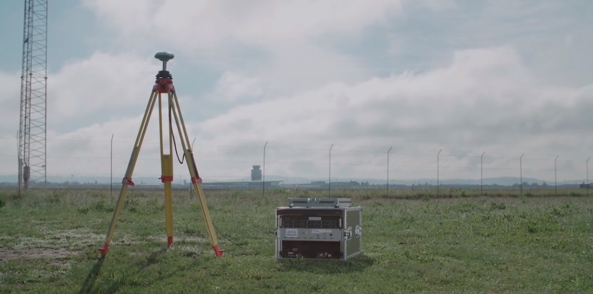
GIDAS can provide interference detection and directionality with a single reporting station, although a minimum of three stations are required for pinpointing interference sources, linked to an overall monitoring center. Monitoring centers can also be connected together, making the GIDAS system easily scalable, from safeguarding an individual harbour, airport or system critical site up to an entire city or region.
GIDAS can provide interference detection and directionality with a single reporting station, although a minimum of three stations are required for pinpointing interference sources, linked to an overall monitoring center. (Photo: ESA)
“People are only now catching up to the seriousness of this problem,” adds Andreas. “Surveys of the highest-density parts of Europe surveys report around three to four jammers hourly.
“These small devices are technically illegal but are easily available online for a few hundred euros or less, often marketed as personal privacy devices. Jammers are sold as having a range of only a few metres, but can turn out to have a practical range of dozens of metres or more — leading to unintentionally widespread interference, like the famous jammer-equipped U.S. truck driver who shut down Newark Airport navigation systems whenever he drove past.
“Spoofing is more serious still, with a strong criminal element, where false satellite navigation signals replace real ones, to mislead receivers about their position, employed in the past to down put drones or divert boats.
“Working in this field for eight to nine years, we have seen a strong growth in interference, even as GNSS becomes ever more crucial. With our passion for GNSS and signal processing, we decided to something practical to combat this development, delivering rapid detection, classification and localisation of interference to our customers.”
GIDAS was developed by OHB Digital Solutions and Joanneum University through ESA’s Navigation Innovation and Support Programme (NAVISP), working with European industry and academia to develop innovative navigation technology.
“The company initiated the project through NAVISP’s second element, focused on strengthening European competitiveness in the navigation arena, proceeding on a co-funded basis,” said engineer Thomas Burger, overseeing GIDAS project for ESA. “The plan was to enable a commercially attractive business to get started, and I’m happy to say we made it.”
“Considering the budget, the project had a wide scope, including the development of a multi-constellation GNSS receiver with all processing stages, an extended digital front end for jamming and spoofing detection, processing blocks transferred to a parallel processor based on a customised fully programmable gate array.
“And that was only one ingredient of the overall GIDAS system, also including the actual interference detection machinery, the interference locating subsystem, and all the communication, database, and graphical user interface elements needed to create a distributed, human-usable system — which is able to go on working autonomously, only asking for human involvement when events are detected.”
Now that its two-year NAVISP project has concluded, GIDAS is now being rolled out to several Europe-based governmental and private sector customers.
The contest targets the design and development of drone-based applications or services, using a Galileo-enabled receiver, to address the European Union’s (EU’s) key priorities such as the Green Deal, and support the EU Recovery Plan for Europe.
Initial ideas should be submitted by Aug. 31. Wide participation from all EU Member States is expected.
According to ESA, the MyGalileoDrone competition seeks to tap into the EU’s innovative spirit to deliver applications and services to boost Europe’s competitiveness, resilience and sustainability. Applications should leverage and demonstrate Galileo’s added value, such as increased accuracy, availability and robustness of position, as well as integrity for a solution based on drone operations.
The market related to drone applications and services is growing rapidly, and European drone service revenues are expected to reach EUR 250 million by 2025. The European demand is estimated to reach EUR 10 billion annually, in nominal terms, to 2035 and over EUR 15 billion annually to 2050, creating more than 100,000 jobs.
With GNSS receivers implemented on almost all new commercial drones, Galileo’s and EGNOS’ added value is pivotal for the development and growth of drone services and applications.
In addition to designing and developing the application, contestants should prepare their drone- based application or service for commercial launch.
The solution should leverage Galileo to provide a position fix. The use of EGNSS is understood in the broad sense, and Galileo can be integrated in the flying platform, the ground control station, or in other devices supporting the operation, such as a smartphone or even in the frame of U-Space services.
“GNSS is a key enabling technology in this segment, ensuring robust navigation and reliability for a wide range of applications. The MyGalileoDrone competition aims to bring oxygen to European SMEs and entrepreneurs driving innovation. It will create jobs and growth in this promising market,” said Pascal Claudel, acting executive director at the GSA.
Focus on EU priorities
In times of post-COVID recovery focus, submissions should target applications and services that support key EU priorities, but the sky’s the limit. The GSA is looking for trailblazing ideas in applications such as smart mobility, sustainable agriculture or environmental protection, or solutions that exploit synergies between 5G and space data, or support the internet of things, or whatever might be the next big thing.
Deadlines and Prizes
The first prize in the MyGalileoDrone competition amounts to EUR 100,000, with EUR 60,000 for second, EUR 40,000 for third, and a fourth prize of EUR 30,000.
After Aug. 31, projects selected to advance to the development phase of the contest will be announced on Sept. 15. Participants will have until Nov. 30 to develop a demo version of their proposed application or service.
In the finals, the selected teams will perform a live demonstration and pitch their ideas to investors. During the development process, the applicants will receive mentoring and coaching from recognized experts in the drone market. These experts will accompany them as they build their application, develop tests and get ready from the business perspective to attract investors and move to market.
To register or for more information, visit the competition page on the GSA website.
GMV will search using artificial intelligence for any correlations between COVID-19 spread and environmental parameters.
Image: ESA
The European Space Agency (ESA) has launched an internal initiative to cull ideas for supporting its member states in the study and analysis of the COVID-19 pandemic. Under this initiative, an idea from the Galileo Navigation Science Office has been selected.
The COVID-19 Space Hunting Platform is designed to facilitate access to and processing of existing COVID-19 databases for epidemiological studies, topping them up with data from ESA’s Earth observation satellites.
The project will use artificial intelligence to look for correlations between COVID-19 spread and environmental parameters, such as humidity and temperature.
The aim is to help researchers generate products and statistics that might be useful for decision-making purposes in terms of protection measures and lockdown, while also vetting the efficiency of the measures taken.
Development of the COVID-19 Space Hunting Platform will be primed by the technology multinational GMV. The Universidad Politécnica de Valencia will also be taking part, with support for processing, data analysis and interaction with diverse epidemiological research groups. The university has defined a mathematical COVID-19 transmission model and has been publishing periodical updates and forecasts of its trend in Spain.
In the medium term, the COVID-19 Space Hunting Platform could help in setting up a collaborative COVID-19 website for scientists to analyze existing data more efficiently, benefiting also from ESA’s data-processing software packages.
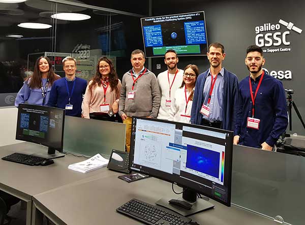
The GSSC team will lead the program. (Photo: ESA)
The project will be carried out around the GNSS Science Support Centre (GSSC) platform, which hosts and indexes COVID-19 data. The three-month process will analyze public COVID-19 data and make this information available to the science community. This will lead to a first version with basic pandemic-propagation algorithms, updated thereafter to ensure the information is always precise and up to date.
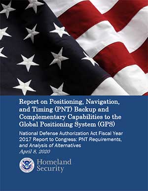
Members of Congress were not pleased with the new U.S. Department of Homeland Security (DHS) report on positioning, navigation and timing (PNT), saying the long-delayed report contained numerous errors and failed to address many of the things Congress had required.
On the April 8, DHS submitted to Congress the brief, 26-page report on the nation’s PNT requirements. It took more than three years to produce and was delivered more than two years late.
In comparison, just two weeks earlier a team of eight British organizations sponsored by the European Space Agency (ESA) issued a 1,174-page report on the PNT needs of maritime commerce. The report from the Maritime Resilience and Integrity of Navigation (MarRINav) project was produced in less than a year.
House Transportation Committee Chair Peter DeFazio (D-OR), Armed Services Readiness Subcommittee Chair John Garamendi (D-CA) and Representative Alex Mooney (R-WV) expressed their disappointment this week in a letter to DHS Acting Secretary Chad Wolf. In addition to outlining their concerns, it asked that the report be retracted, rewritten and resubmitted within six months.
While the letter did not specifically mention the contrast between the DHS and British efforts, it did use the MarRINav report as a reference. And it was clear that the disparity in length and quality of the reports accentuated the disappointment for those who had hoped for a better product from DHS.
The letter asked that the report be retracted, rewritten and resubmitted within six months.
Factual errors
Factual errors in the DHS report, according to the letter, included getting the mandated timing for financial systems wrong, and mischaracterizing coverage areas and capabilities of various technologies including several that had been recently demonstrated for the Department of Transportation (DOT).
The letter also observed that DHS focused on commercial PNT users to the detriment of most Americans. It failed to consider the needs of public service organizations, governmental entities, and individual citizens in its analysis.
The lawmakers contend the report did not recognize that PNT provided by GPS is frequently a safety-of-life service and a public good that must be reinforced to protect economic vitality and national security.
Suspending operations, subscribing are flawed options
Two of the solutions to temporary GPS disruptions suggested in the DHS report are for users to suspend operations until the disruption is over, and to have purchased commercial PNT services as backups in advance of a disruption.
Suspending operations for emergency services and other critical functions is unacceptable, say the congressmen. And commercial PNT services to provide needed wide area PNT backups are not available.
Even if they were available, questions of affordability for the many non-profit and public entities that needed them, whether it would be more cost effective for the federal government to support such services, and similar issues would need to be addressed before the department could make a recommendation.
Suspending operations for emergency services and other critical functions is unacceptable.
No national backup
The letter also observed that the department has discounted the value of a national backup system, a position that seems to conflict with both longstanding and recent presidential policy. Having a backup for GPS has been policy since President Bush established the requirement in 2004. President Trump’s recent Responsible Use of PNT Executive Order called for a national research program on non-space-based PNT and “…mandates the Department of Commerce make available a GNSS independent source of Coordinated Universal Time for all users.”
DHS’ recommendation against a national backup also differs from the Europe/UK MarRINav report. In addition to calling for improvements to be made by commercial entities such as port and ship operators, MarRINav identifies the need for “terrestrial and sovereign” eLoran and VHF DES Ranging mode systems to support reliable maritime commerce. Establishing such systems will require support by the national government.
Most members of industry agree that some government involvement is needed. A CEO of one of the companies demonstrating its backup technology for DOT observed that the market would never solve the problem on its own.
“We have tried for 16 years to figure out a business case, and it’s just not there,” the CEO said. “GPS is too good and it’s free. You can’t compete with that. If America is going to have one or more new wide-area capabilities that most people can use — not just niche solutions for high-demand, well-heeled customers — the government is going to have to prime the pump.”
DHS did propose some efforts that resonated with the Congressmen, such as encouraging use of GPS receivers that resist spoofing and jamming. The lawmakers described these as “necessary but grossly insufficient” before requesting the report be withdrawn and redone.
DHS’ “Report on Positioning, Navigation, and Timing (PNT) Backup and Complementary Capabilities to the Global Positioning System (GPS)” is available here.
The letter from Congressmen DeFazio and Garamendi is available here.
The Maritime Resilience and Integrity of Navigation (MarRINav) project report is available here.
In 2018 the first-ever European Radionavigation Plan said “It is recognized that [..] GNSS should not be the sole source of PNT information. Alternative PNT systems, not necessarily using radio frequencies, should thus be put in place where the criticality of the application requires it.”
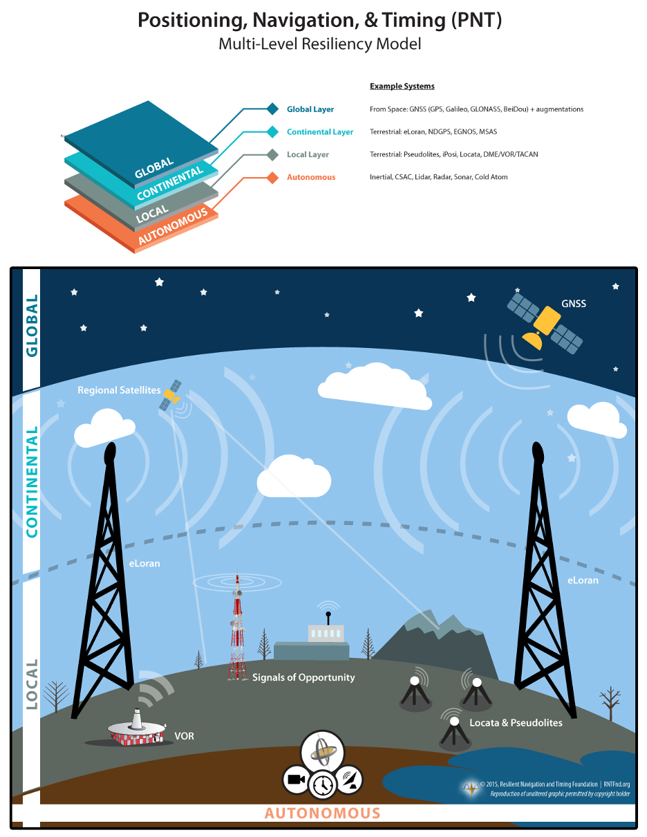
Graphic from MarRINav report showing system of systems approach to PNT resilience and reliability. (Image: Resilient Navigation and Timing Foundation)
In 2019 the European Space Agency (ESA) published a permanent open call for proposals for positioning, navigation, and timing studies and systems, including those that had nothing to do with space.
“Maritime navigation and port operations are critical for almost every nation,” said Jonathan Turner, one of the MarRINav project team. “As an island nation with a strong maritime heritage, we in the United Kingdom perhaps have an even greater appreciation of this.” Turner is co-founder of the blue economy solutions company NLA International, which led a team of eight organizations cooperating on the project.
While MarRINav focused its analysis on the United Kingdom, the intent was to provide information, and an analysis framework, that could also be used by other nations.
Maritime is one of sectors most dependent upon GNSS, according to the project reports, and a sector with great awareness of GNSS vulnerabilities and their consequences. MarRINav concludes that integrity and resilience are two of the most important parameters for maritime navigation.
Maritime is also one of the sectors most ready to integrate space and terrestrial navigation systems, according to the report’s authors. The International Maritime Organization has already introduced a performance standard for a multi-system receiver, or MSR, that will incorporate a wide variety of navigation signals.
Despite the distractions of Brexit over the last four years, the United Kingdom has been particularly focused on its vulnerability to GNSS outages.
In February of this year the UK government announced it was establishing a virtual National Timing Centre to protect the nation from the risk of GNSS failure, and in March the final MarRINav report was published.
Among the project’s findings are that:
The United Kingdom needs a comprehensive maritime PNT architecture with multiple, diverse sources to ensure continuity of maritime operations
Such a “hybrid solution” could benefit other sectors, especially if non-maritime needs were considered early in the design
New PNT systems should be terrestrial and sovereign
Establishing such a system for the UK has a very positive benefit to cost ratio
Important aspects of the new architecture are E-GNSS (Galileo and EGNOS), Enhanced Loran (eLoran) and the Ranging Mode (R-Mode) of the VHF Data Exchange System (VDES), and complemented by the development of a specific Maritime Receiver Autonomous Integrity Monitoring (M-RAIM) algorithm.
LOCATA or a similar local positioning system should be implemented at UK ports to provide a backup for container operations.
Satelles Satellite Time and Location may have potential, but its utility has yet to be demonstrated for maritime.
GPS World is offering the latest news and updates concerning the coronavirus (COVID-19) pandemic as it affects the GNSS/PNT industry. Read a message from GPS World here.
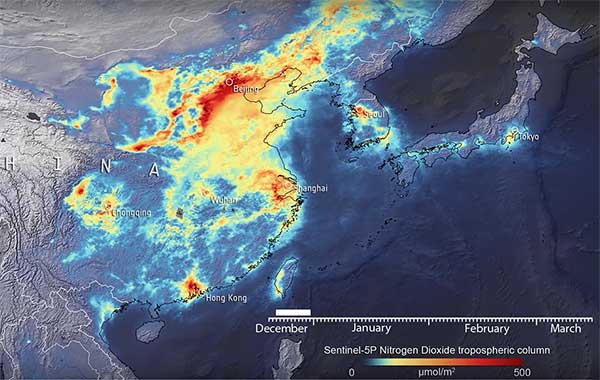
Descartes Labs, a geospatial data analytics company, is using satellite imagery analysis to examine how the coronavirus reduced nitrogen dioxide (NO2) emissions in China.
NO2 is produced by vehicles, power plants and heavy industries such as cement manufacturing, which were shut down during the coronavirus epidemic.
Descartes Labs shared its visualization in a Facebook post. The visualization maps a time series of NO2 levels across Eastern China, Japan and the Korean Peninsula using data from the European Space Agency (ESA) Sentinel-5P satellite.
Plots of NO2 emissions from 2019 compared to 2020 show declines of nearly 60%. Read more on Descartes Lab’s blog.
Copernicus data shared
In a video provided by ESA, a drop in concentrations in late January is visible in China, coinciding with the nationwide quarantine; from the beginning of March, the nitrogen dioxide levels have begun to increase.
Italy reduction
Copernicus data also reveals the decline of air pollution, specifically nitrogen dioxide emissions, over Italy. This reduction is particularly visible in northern Italy, coinciding with its nationwide lockdown to prevent the spread of the coronavirus.
“Satellites offer a unique vantage point to monitor the health of our planet,” said Josef Aschbacher, ESA’s director of Earth Observation Programmes. “Sentinel-5P is one of seven Copernicus satellites in orbit today. It currently provides the most accurate measurements of nitrogen dioxide and other trace gases from space.
“As nitrogen dioxide is primarily produced by traffic and factories, it is a first-level indicator of industrial activity worldwide,” Aschbacher said. “What is clearly visible is a significant reduction of nitrogen dioxide levels over China, caused by reduced activity due to COVID-19 restrictions, but also the Chinese New Year in January. The Copernicus programme is a perfect example of how space serves all European citizens by combining the political strength of the EU with the technical excellence of ESA.”
“We can certainly attribute a part of the nitrogen dioxide concentration reduction to the impact of the coronavirus,” said Claus Zehner, ESA’s Copernicus Sentinel-5P mission manager. “We currently see around a 40% reduction over Chinese cities, however these are just rough estimates, as weather also has an impact on emissions. We are conducting a detailed scientific analysis which will soon provide more insights and quantified results in the following weeks and months.”
The Copernicus Sentinel-5 Precursor mission, also known as Sentinel-5P, is dedicated to monitoring air pollution by measuring a multitude of trace gases as well as aerosols — all of which affect the air we breathe.
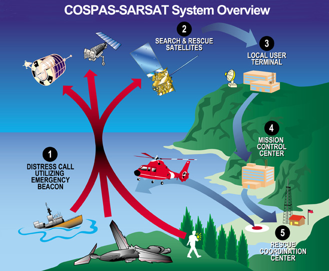
As well as providing global navigation services, Europe’s Galileo satellite constellation is contributing to saving more than 2,000 lives annually by relaying SOS messages to first responders. And from now on the satellites will reply to these messages, assuring people in danger that help is on the way.
This ESA-design return link system, unique to Galileo, was declared operational this week, during the 12th European Space Conference in Belgium. The delivery time for the return link acknowledgement messages from initial emergency beacon activation is expected to be a couple of minutes in the majority of cases, up to 30 minutes maximum, depending primarily on the time it takes to detect and locate the alert.
Cospas-Sarsat rescue beacon activated. Its signals are picked up by satellites in orbit, including Galileo. (Photo: GSA)
“Anyone in trouble will now receive solid confirmation, through an indication on their activated beacon, informing them that search and rescue services have been informed of their alert and location,” explains ESA’s Galileo principal search and rescue engineer Igor Stojkovic. “For anyone in a tough situation, such knowledge could make a big difference.”
All but the first two out of 26 Galileo satellites carry a Cospas-Sarsat search and rescue package. At only 8 kg in mass, these life-saving payloads consume just 3 percent of onboard power, with their receive-transmit repeater housed next to the main navigation antenna.
Image: ESA
Founded by Canada, France, Russia and the US in 1979, Cospas-Sarsat began with payloads on low-orbiting satellites, whose rapid orbital motion allows Doppler ranging of distress signals, to pinpoint their location. The drawback is these fly so close to Earth that their field of view is comparatively small.
Geostationary satellites went on to host Cospas-Sarsat payloads. These see much more of the planet, but because they are motionless relative to Earth’s surface, Doppler ranging is not possible.
Medium-orbiting satellites such as Galileo – orbiting at 23 222 km altitude – offer the best of both worlds, providing a wide ground view by multiple satellites combined with time-of-arrival and Doppler ranging techniques to localise SOS signals. This improves the maximum signal detection time from four hours to less than five minutes, down to one or two kilometres (within a formal specification of 5 km within 10 minutes).
Galileo’s Search and Rescue service is Europe’s contribution to Cospas-Sarsat, operated by the European Global Navigation Satellite System Agency, GSA, and designed and developed at ESA. As the overall Galileo system architect and design authority, ESA has been responsible for the interface between the core Galileo infrastructure to the Return Link Service Provider facility, procured by the European Commission and operated by French space agency CNES.
The Cospas-Sarsat satellite repeaters are supplemented by a trio of ground stations at the corners of Europe, known as Medium-Earth Orbit Local User Terminals (MEOLUTs), based in Norway’s Spitsbergen Islands, Cyprus and Spain’s Canary Islands and coordinated from a control centre in Toulouse, France. This trio is soon to become a quartet, with a fourth station on France’s La Reunion Island in the Indian Ocean under development.
The satellites relay distress messages to these MEOLUTs, which then relay them to local search and rescue authorities.
A public demonstration of Galileo’s return link service was performed at the Cospas-Sarsat Joint Committee Meeting in Doha in Qatar in summer 2019. ()Photo: ESA)
The service’s return link message capability was developed as an inherent part of the Galileo system. The messages are relayed to the individual beacons that sent the original distress call by being embedded within Galileo signals broadcast from satellites in their view.
“The switching on of the return link service was enabled by a thorough test campaign carried out by ESA, with the support of the GSA and CNES,” adds Igor. “We needed to be sure the service remains reliable even with multiple distress calls being replied to at once.”
A key milestone was a public demonstration of the return link service, performed at the Cospas-Sarsat Joint Committee Meeting in Doha in Qatar last summer.
“The return link is a joint service of Cospas-Sarsat and Galileo and therefore agreement by Cospas-Sarsat was crucial,” adds Igor.
“This acceptance was achieved through long discussions led by the European Commission at the Cospas-Sarsat Council last November, supported by plentiful documentation of simulations and test results provided by ESA and CNES.”
By Javier Benedicto
Head, Galileo Programme department,
European Space Agency
Javier Benedicto, left, accept the 2018 GPS World Satellites Leadership Award on behalf of Giuliano Gatti of the European Space Agency, from Phil Froom of Rockwell Collins. (Photo: Melanie Beus)
Since the Galileo initial services declaration in December 2016, the Galileo Program has been providing global PNT and search-and-rescue services for users worldwide. The European GNSS Agency (GSA) just issued its GNSS 2019 Market Report in October, providing a complete overview of the current status and trends of the GNSS worldwide market with focus on European GNSS (Galileo and EGNOS) applications and services.
In parallel with service provision, the Galileo Program is undertaking extensive infrastructure development and deployment activities to reach Full Operational Capability (FOC), incorporating new service capabilities, but above all aiming at increasing the robustness and resilience of the system infrastructure, operations and service provision.
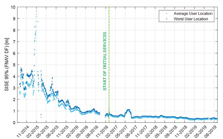
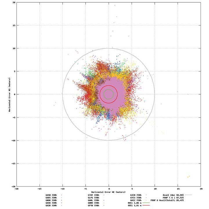
Galileo’s signal-in-space quality has steadily improved over the past few years, reaching in 2019 a best signal-in-space error (SISE) of about 0.25 meters (95%, global average; Figure 1). This has been achieved through a combination of several factors, including the increased number of operational satellites, enhanced versions of the Ground Mission Segment, and higher uplink rate of the navigation message (lower age of data). This performance is well within Galileo’s initial service accuracy commitments, as defined in the public Open Service – Service Definition Document (OS SDD).
Figure 1. Long-term historical SISE plot over a 30-day sliding window, constellation averaged. (Image: ESA)
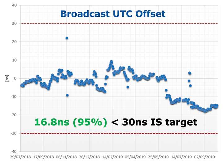
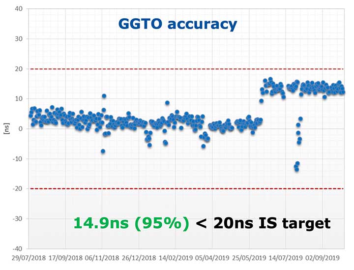
Figures 2 and 3 (see page 40) show Galileo’s timing performance as broadcast UTC offset and GGTO accuracy. The evaluation was performed with calibrated GPS/Galileo timing receivers operated in UTC(k) laboratory (PTB, INRIM). Again, the initial timing service commitments have been fully met.
Probably the most significant discriminator of Galileo compared to other GNSS is its capability to broadcast multi-frequency (E1, E6, E5) signal components on all operational satellites. The position performance of a dual-frequency user receiver on-ground is shown in Figure 4. This measurement from June 2019 demonstrates a Galileo position accuracy well below 2 m (95%).
Figure 4. Galileo position accuracy performance, dual-frequency, June 2019. (Image: ESA)
With the aim of further improving the Open Service (OS) performance, three newly introduced I/NAV message improvements on Galileo E1-B are under implementation, namely FEC2 Reed-Solomon Clock and Ephemeris (CED), Reduced CED, and Secondary Synchronization Pattern (SSP). Galileo Open Service (OS) users will benefit from improved robustness in terms of navigation data retrieval in challenging environments, in addition to facilitating a reduced time to first fix. Those I/NAV improvements on Galileo E1-B are backwards compatible with previously released OS SIS ICDs.
In addition, Galileo infrastructure is currently being upgraded to provide means for OS authentication. The protocol proposed uses the E1B External Data Broadcast Service (EDBS) to provide authentication data to the user. The OS Navigation Message Authentication (NMA) is based on an adaptation of the Timed Efficient Stream Loss-tolerant Authentication (TESLA) protocol.
Beyond the OS, the Galileo system has been designed to allow for the dissemination of value-added data, such as high accuracy and authentication, in the E6B signal component. The component has been designed to broadcast the Galileo High Accuracy Service based on the provision of accurate satellite data (clocks, orbits and biases) and atmospheric data (mainly ionospheric corrections) to enable multi-frequency multi-constellation PPP with correction data transmitted through an open format in the Galileo E6B signal.
The introduction in early 2020 of the automatic acknowledgment of the SAR/Galileo Return Link Message (RLM) as part of the Cospas-Sarsat system will enable space assets to be used for search and rescue — persons in distress will get swift acknowledgement that their alert has been detected and located. The Return Link is the means to interact with a SAR beacon, improving the effectiveness of SAR operations. Extensive testing has demonstrated that the median latency for the reception of a return link message on the ground is 14.2 seconds, while 99% of messages are received within 57 seconds, after the request for the RLM transmission is delivered to Galileo (from Cospas-Sarsat to the RLSP). At the same time, the measured rate of reception was 100%, considering line-of-sight availability, thanks to the very robust Galileo navigation data link. This performance has been demonstrated to be uniform across the globe, as shown in Figure 5.
Figure 5. Beacon activation map and RLM delivery latency through the Galileo system. (Image: ESA)
Following the re-profiling of the Galileo Safety-of-Life (SoL) service, Galileo is meant to be exploited through dual-frequency multi-constellation (DFMC) SBAS and will support the provision of integrity through the concept of Horizontal Advanced Receiver Autonomous Integrity Monitoring (H-ARAIM). To allow the exploitation of Galileo for these SoL applications, a thorough analysis of the actual signal-in-space (SiS) performance and of potential feared events critical for SoL users is key. In this context, the Galileo Integrity Failure Mode and Effect Analysis (IFMEA) process is implemented through measurements and review of the system design, including feared-events characterization.
Ground Segment Brings Robustness
Galileo telemetry and telecommand ground station. (Photo: ESA)
Galileo’s Ground Segment is being upgraded to fully redundant control centers. These include processing and storage, monitoring and control facilities, and security monitoring centers. A worldwide network of Galileo Sensor Stations (GSS) allows monitoring and measuring of satellite signals; uplink stations allow dissemination of the navigation message to users through Galileo satellites; and telemetry, tracking and control (TTC) stations allow monitoring and control of the satellites.
Ground segment upgrades under production by Thales Alenia Space France (in charge of the ground mission segment and security monitoring) and GMV Spain (in charge of the ground control segment) are addressing increased service robustness, through the introduction of a more flexible infrastructure with a significant technology refresh, improved security, service continuity, enhanced service performances, and enhanced operability features.
One important objective of the ongoing upgrades is to implement a modern infrastructure, based on leading virtualization technologies. This modernized infrastructure will make it possible to easily accommodate hardware and software changes without requiring significant redesign or requalification, and will minimize the impact to Galileo service operations — under responsibility of Spaceopal GmbH — during future deployment activities.
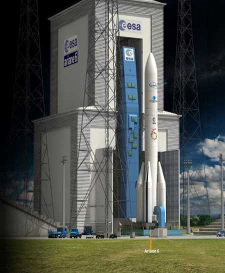
Batch 3, Ariane 6 Under Production
Ariane 6 on the launchpad. (Artist’s concept: ESA)
The production of Batch 3 of 12 additional Galileo FOC satellites is proceeding, aiming at readiness for launch by the end of 2020 onward. The satellite design includes a selected number of improvements compared to the 22 FOC satellites launched previously and built by the same satellite manufacturer OHB Systems.
The different stages of assembly, integration and initial test phase in the OHB production plant in Bremen have already started, before shipment to ESA-ESTEC in the Netherlands for the environmental test campaign consisting of thermal vacuum, mechanical tests, interface verification with the launcher and system end-to-end performance tests with the elements of the Galileo ground segment.
Following the phasing out of the Ariane 5 SE launcher, the third batch of Galileo satellites will be progressively launched with the new Ariane 62 launcher vehicle, the two solid-booster variant of Ariane 6 now in the final stages of development.
Evolution to Meet User Needs
The Galileo Second Generation roadmap has achieved maturity in 2019 and is now entering the preliminary design and implementation phase. Based on the EU’s H2020 Galileo Second Generation activities managed by ESA, and the GSA prospective market analysis, the European Commission, in close consultation with EU member states, has agreed on an ambitious set of long-term PNT goals for the future European GNSS infrastructures.
Technology pre-developments, critical engineering activities and synergic design activities between space and ground infrastructure are being conducted. This will translate into the progressive deployment of a complete set of space/ground infrastructure that is tailored to satisfy the diversified user needs in four main dimensions:
Satellite and ground segment infrastructure with capabilities that can dynamically adapt to current and future user needs. Key drivers are flexibility and robustness, ensuring fast time to market to meet user needs.
Full synergy between GNSS and SBAS systems infrastructure, to complement and enhance the service portfolio. This will allow segmentation and complementarity of safety-critical services and extension to all new PNT services available today, including high-accuracy positioning integrity.
Enhanced integration with terrestrial systems — 5G/6G, signals of opportunity (SOOP), terrestrial beacon systems (TBS). ESA and GSA have been actively leading the 5G positioning standardization worldwide in collaboration with public and private institutions inside 3GPP and will soon move toward the start of standardization of 6G terrestrial positioning and GNSS interconnection technologies.
Full complementarity with external sensors (such as INS, barometer and lidar) and application environments (low-power devices and internet of things) so that the Galileo Second Generation Infrastructure enhances and complements the capabilities provided by these external means.
A key pillar for this long-term strategy is the Galileo transition satellites. The competitive procurement procedure for the first batch of transition satellites is coming in 2020. The flexibility and robustness of these satellites will allow the European PNT infrastructure to satisfy all the different user needs in the next decade. This procurement — together with others at system, ground segment and technology level — will enable the start of the in-orbit validation of second-generation capabilities from 2025 onward.
Additional ground and test infrastructure are in early engineering analysis, design and technology development, in order to proceed with additional procurements for experimental and operational usage, starting early in the 2020s.
A free GPS World webinar on Nov. 21 tackles a new frontier, if not the final one, for GNSS. “Developments in Space GNSS Navigation,” sponsored by NovAtel, brings together experts from NASA, ESA, NovAtel and Spire (the CubeSat company) to discuss how they’re taking GNSS capabilities beyond Earth’s boundaries.
Navigating through space has long proven to be challenge for aerospace engineers and professionals because of the complex combination of technology and cost required for success.
However, with advancements in GNSS and receiver technology, organizations and nations around the world are increasingly interested in space exploration activities.
Today, the space industry is seeing GNSS technology used in low-Earth orbit (LEO) and highly elliptical orbit scenarios.
In this webinar, speakers from NASA, ESA (the European Space Agency), NovAtel and Spire will examine emerging trends regarding the usage of GNSS technology in the space industry, including an increasing need for situational awareness while navigating through space and the ability to service satellites while in orbit.
These experts will also provide a look into their own experiences with a variety of ambitious space projects and applications.
Speakers include:
Werner Enderle, Head of Navigation Support Office, ESA European Space Operations Center
Benjamin Ashman, Aerospace Engineer, NASA
Erin Kahr, Critical Safety Systems, NovAtel
Dallas Masters, GNSS Program Manager, Spire
Date: Thursday, November 21, 2019 Time: 1 p.m. EST / 10 a.m. PST / 7 p.m. (1900h) Central European Time
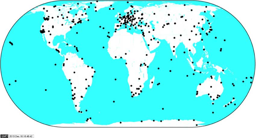
There are more than five billion satnav devices on Earth. Along with smartphones and mobile receivers, this figure includes networks of fixed receiver stations, used to improve accuracy. An ESA-led project will harness these networks to provide an ongoing overview of satnav performance from the global to national and regional scale.
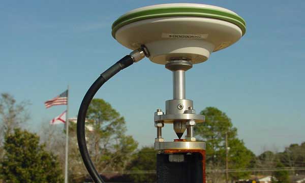
CORS station: The CORS network is a multi-purpose cooperative endeavor involving government, academic and private organizations. The sites are independently owned and operated. Each agency shares its data with NGS, and NGS in turn analyzes and distributes the data free of charge. (Photo: NOAA)
“The general assumption is that Global Navigation Satellite System (GNSS) services can always be relied on, which is true 99% of the time,” commented Michael Pattinson of Nottingham Scientific Ltd. in the United Kingdom, which is developing this new project for ESA.
“That’s fine for the ordinary smartphone user, but for safety-critical applications, in particular, we need to know exactly when systems are not performing optimally, and why.
“Current performance monitoring is often partial, based around individual signal frequencies or constellations, carried out by the service operators themselves. With our new COLOSSUS — Crowd-Sourced Platform for GNSS Anomaly Identification, Isolation and Attribution Analysis — data platform, we’ll be creating the most detailed possible picture of overall performance from the user side, covering all satellite constellations, signal frequencies and receiver types.
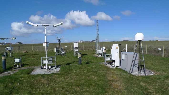
OS Net Station: A CORS station in Tiree, the Hebrides, part of the Ordnance Survey’s 110-strong OS Net network. (Photo: Ordnance Survey)
“The aim is to immediately identify system failures, faults and other errors on an immediate, autonomous basis. And we’ll do this by harnessing a resource that is already out there: gathering and analysing positioning data from networks of ‘continuously operating receiver stations’, known as CORS for short.”
There are many hundreds of these CORS stations across the globe. By performing positioning continuously at a fixed site in the landscape, they can be used as a standard, serving to identify and subtract measurement errors to boost positioning accuracy on a localised basis.
Many CORS networks have been established for scientific uses, such as the worldwide International GNSS Station (IGS) network, used as a standard geographical reference and to measure shifts in the solid Earth, oceans and ice.
Others have been set up by national mapping agencies, such as the Ordnance Survey in the UK. There are also private-sector networks, employed for improving the accuracy of services such as land surveying, air service providers, road charging or driverless cars.
IGS Global Network: the worldwide International GNSS Station (IGS) network of CORS stations is used as a standard geographical reference and to measure shifts in the solid Earth, oceans and ice.(Image: ESA)
“Each network is different,” added Pattinson. “Some make their data freely available, others involve registering or payment. We’re talking to operators to allow us to access their data in exchange for sharing our results, and they’re very interested in accessing such performance metrics.
“With measurements from so many sites, when a failure does occur we’ll be able to pin down its likely source almost immediately. Is it localised interference, or does it have a wider impact? Is it atmospheric disturbance? Is only a single model of GNSS receiver affected, or multiple types? Is it a problem with a single satellite, multiple satellites or even multiple constellations?”
The company is also deploying its own CORS receivers as an additional data source, at the same time as it develops and tests its processing algorithms. The aim is to begin testing the cloud-based COLOSSUS towards the end of 2019 and bring the service online in the first few months of 2020.
“Once the service starts, it will run continuously, just like the CORS stations themselves,” Pattinson said. “Our goal is for COLOSSUS to become a key player in GNSS performance monitoring, building up a database of all anomalies that occur and their consequences in terms of constellations, geographical regions and receiver types, to give users, service providers, and regulators an informed sense of how much ‘trust’ to place in these systems.”
This project is supported through ESA’s Navigation Innovation and Support Programme, NAVISP, applying ESA’s hard-won expertise from Galileo and Europe’s EGNOS satellite augmentation system to new satellite navigation and — more widely — positioning, navigation and timing challenges.
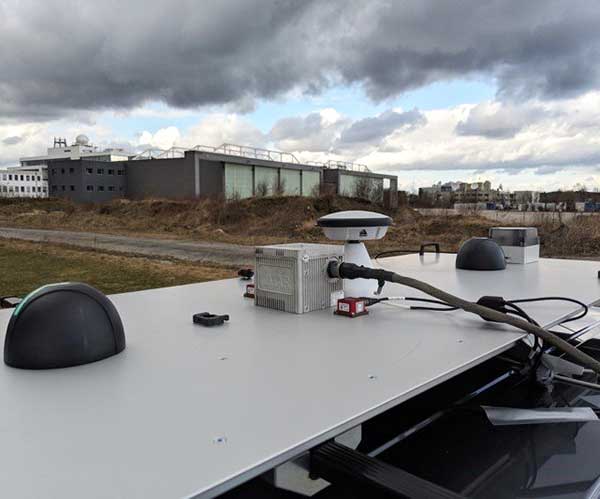
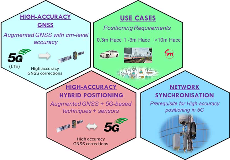
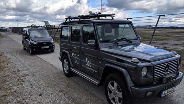
A pair of testbed vehicles went out on the road in Germany to simulate the way we are all likely to be using 5G positioning services in the future. The field test focused on assessing the performance of highly precise hybrid satellite/terrestrial positioning for autonomous vehicles, drones, smart cities and the internet of things (IoT).
The two vehicles were driven for a week around Munich and the surrounding area in a variety of environments, from the open-sky terrain surrounding the German Aerospace Center DLR’s site in Oberpfaffenhofen to the deep urban canyons of the city’s dense Maxverstadt district.
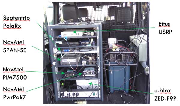
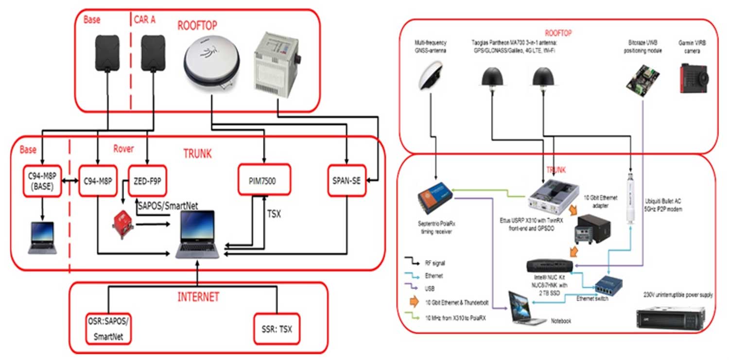
As they drove, they combined a broad range of on-board systems to measure their positions and share them with one another, performing ongoing vehicle-to-vehicle ranging to simulate future 5G operating standards.
The on-board systems included multi-constellation satellite navigation (combining Europe’s Galileo, the U.S. GPS, Russian GLONASS and Chinese BeiDou), incorporating localized high-accuracy correction, and 4G Long-Term Evolution (LTE) and ultra-wideband (UWB) terrestrial wireless broadband communication.
The coming of the next generation of mobile phone networks, 5G, promises much faster, more stable connectivity based on higher bandwidths and frequencies, but the ability to download a full movie in a matter of seconds is only the start. The increased capabilities will also open up a new range of services, many of them based around localization.
From smart traffic management to asset tracking to personalized drone-based delivery, our receivers’ ability to know where they are and share those positions with the wider network will be vital.
Close-up view of Car A with GNSS and LTE antennas. (Photo: ESA)
“The first step required is understanding what the upcoming disruptive applications are, and to identify the potential requirements associated with them,” said Riccardo de Gaudenzi, who leads ESA’s Electrical Department in its Directorate of Technology, Engineering and Quality.
“For these use cases, positioning and timing are key elements. Therefore positioning, navigation and timing (PNT) aspects, provided via GNSS like Galileo, the terrestrial communication infrastructure and hybridization of technologies, are extremely important.”
The testbed vehicles combined a broad range of on-board systems, including multi-constellation GNSS, incorporating localized high-accuracy correction. (Image: ESA)
Today we rely largely on satellite navigation to determine where we are. But our smartphones quietly blend satnav with other data sources to sharpen the accuracy of their results. That is why, for example, when you turn off your phone’s Wi-Fi receiver, your smartphone will warn you its mapping will become less accurate – it is also using Wi-Fi maps as a reference source.
With 5G, this trend of hybrid positioning will accelerate. Multiple GNSS constellation will be employed to increase accuracy, along with localized correction systems. In addition, the 5G cell network will provide additional corrections to enhance the GNSS localization accuracy and to complement GNSS when satellites are not visible.
This 5G “new radio” positioning accuracy will be enhanced by using steerable antennas on both the base station and the user terminal.
The testbed vehicles combined a broad range of on-board systems, incorporating localized high-accuracy correction and LTE 4G and ultra-wide-band terrestrial wireless broadband communication, to measure their positions and share them with one another and perform ongoing vehicle-to-vehicle ranging to simulate future 5G operating standards. (Image: ESA)
And because positioning performance will have to remain at the same high standard as user receivers move around — whether they be people, cars, shared bikes or drones — additional positioning solutions will also be employed, such as inertial sensors or device-to-device relative positioning.
Areas where ESA is contributing to 3GPP standardisation efforts. (Image: ESA)
Miguel Manteiga Bautista, head of ESA’s GNSS Evolution and Strategy Division in the Agency’s Directorate of Navigation, explains, “For the hybrid positioning field-tests, ESA and its partners set up a collaboration with Deutsche Telecom for use of its 4G network in Munich including relevant information for positioning, and NovAtel, who provided state-of-the-art GNSS equipment and correction services, such as the satellite-based TerraStar-X.”
ESA oversaw this initial field test campaign as part of its 5G GNSS Task Force, coordinated with the European Commission and the European GNSS Agency through the Horizon 2020 Framework Programme for Research and Innovation in Satellite Navigation.
The field test campaign was undertaken by DLR and the GMV company, with contributions by engineers from NovAtel, u-blox and Deutsche Telekom as well as ESA.
In 2016 the 5G GNSS Task Force within H2020 took the initiative to shape the support of high-accuracy positioning services in 4G and 5G networks, to contribute to the 3rd Generation Partnership Project, 3GPP, worldwide standardisation effort.
These field tests are executed within the GNSS Integration into 5G wireless networks or GINTO5G project. Undertaken through ESA’s European GNSS Evolution Programme, this project is being is executed by a consortium composed by GMV, Universitat Autonoma de Barcelona (UAB), DLR, u-blox and Telefonica I+D.
Currently, UAB is involved in the thorough processing of all the data gathered during the field test campaign, leading into models and simulation tools and possibly additional field experiments.
This pair of testbed vehicles went out on the road in Germany to simulate the way we are all likely to be using 5G positioning services in the future. (Photo: ESA)