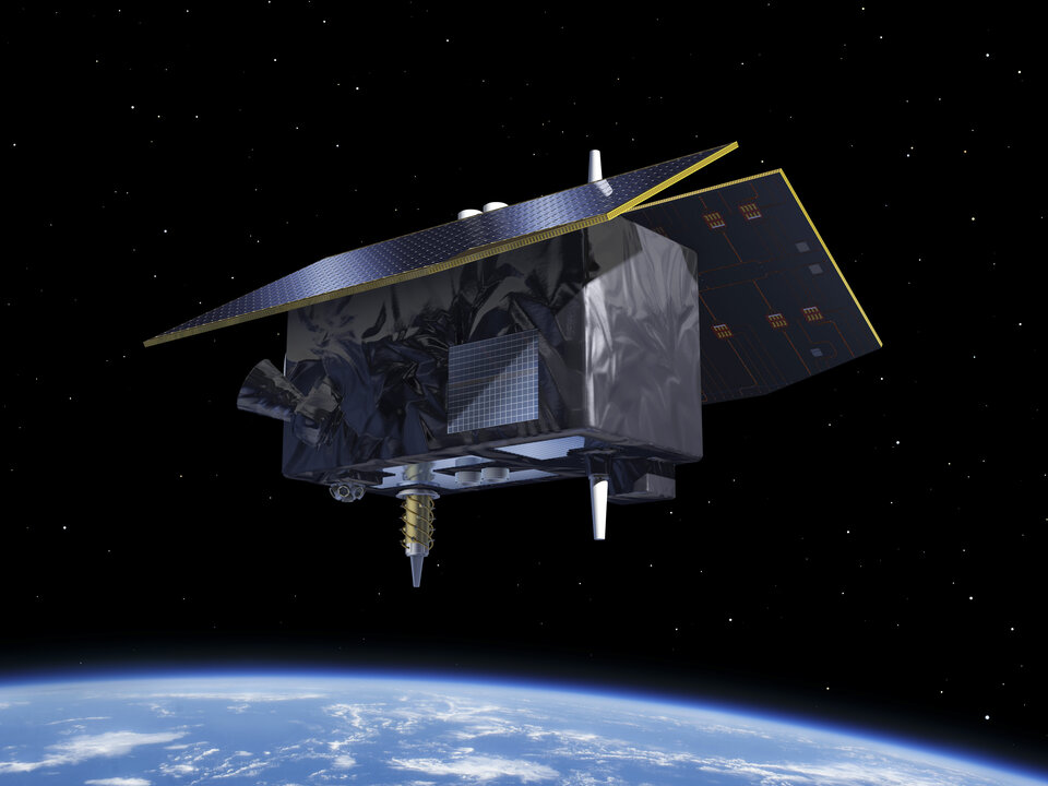
The European Space Agency (ESA) has upgraded the ground segment of the Galileo satellite navigation system, without any disruption to its users. This update enhances the Galileo Control Segment responsible for managing the constellation of orbiting satellites.
The upgrade involved a series of improvements to both the operational control centers and the extensive network of ground stations. These enhancements are designed to boost the robustness and reliability of the Galileo system, which is crucial to critical applications such as navigation, timing services and emergency response.
With Galileo’s First Generation close to completion, the ground segment required an upgrade to System Build 2.0 to bring critical enhancements to the system, especially for the roll-out of the Public Regulated Service (PRS), which provides highly accurate and robust encrypted signals for authorized governmental users
With the cooperation of the European Union Space Programme Agency (EUSPA) and key industrial partners, ESA ensured a seamless transition, highlighting the effectiveness of international collaboration in advancing satellite navigation technologies.
Click here to visit the official ESA blog and learn more.
The Grimaldi Satellite Autonomous Berthing (GSAB) project, funded by the European Space Agency (ESA) Navigation Innovation and Support Program (NAVISP) program, has developed a system for automatic, high-precision port berthing operations in large (200m) carrier ships. The system offers ship captains and crew with an overview of ship conditions in real time port settings, including detailed information on maneuvering operations.
Project leader Grimaldi Euromed, in collaboration with two divisions of Kongsberg, conducted the research and development of the new system, including integrating various sensors to provide accurate positioning and ranging data with high integrity. The GSAB system suggests the best path for berthing based on all available and relevant information sources, while augmented reality (AR) goggles provide an intuitive method of visualizing critical berthing information.
System subcomponents include an inertial navigation system (INS) where GNSS measurements are fused with motion/attitude data from the Kongsberg motion gyro compass (MGC). This allows the system to deliver robust and precise data on vessel location, velocities and acceleration. A perception system includes a camera-based sensor for determining steel-to-steel distances from the vessel to any obstruction and quays.
Kongsberg illustrated increased efficiency using to the new system, including a clear reduction in the time required to enter and exit from a port, and a corresponding decrease of emitted pollutants.
Radiolabs, a non-profit research organization, recently joined the GSAB consortium. It focuses on investigating and prototyping a new ground truth reference system, which integrates and fuses GNSS, IMU, and lidar-derived data to provide highly accurate positioning and ranging.
At the recent final presentation of the GSAB project, hosted by ESA, Federica Pascucci of Radiolabs described the results of the project, based in part on previous work in the automotive sector. She said the GSAB work was promising, having verified the effectiveness of Radiolabs’ lidar-based system for positioning, with adaptations necessary for application in maritime scenarios.
The GSAB project demonstrated significant potential cost and time savings benefits and improved safety and environmental performance. The partners will continue their work in the framework of a new ESA NAVISP-funded project, GSAB2, to demonstrate the system’s use in increasingly autonomous vessels and apply newly developed, advanced algorithms based on artificial intelligence.
The European Space Agency (ESA) has selected Syntony GNSS to supply user demonstration receivers for its low-Earth orbit positioning, navigation and timing (LEO-PNT) project.
Led by Thales Alenia Space and funded by ESA, the first European LEO-PNT project aims to enhance PNT services from LEO. This initiative is expected to improve the accuracy and reliability of navigation systems, serving a wide range of applications, from critical emergency services to everyday technologies.
Syntony will provide its ground receivers, compatible with the new LEO/PNT signals, as well as with GPS and Galileo systems. These receivers will initially assess the performance of signals from the constellation, which will start with fewer than 10 satellites. There will be 100 to 600 satellites when the constellation is complete, according to Syntony.
Although the receivers may not always be able to calculate position, velocity, and time (PVT) due to the lack of available satellites, they will be essential in evaluating signal performance when at least four satellites are visible. This allows for PVT calculations and performance comparisons with existing GNSS systems.
Syntony’s software-defined radio (SDR) receivers enable real-time adjustments to the receiver settings to evaluate the constellation’s performance. This can be achieved without any hardware changes, as the LEO-PNT constellation uses frequencies similar to those used by the medium-Earth orbit (MEO) GNSS systems.
Syntony’s Constellator GNSS Simulator will be updated to incorporate the constellation’s signals as soon as they are available. This process is similar to how the signals from Xona Space Systems’ PULSAR constellation were integrated as early as 2022.
In early 2015, the Navigation Support Office of the European Space Agency (ESA) and the Japan Aerospace Exploration Agency (JAXA) began a collaboration. At its core, the ESA-JAXA collaboration is designed to cross-validate Japan’s Quasi-Zenith Satellite System (QZSS) Precise Orbit Determination (POD) results and share expertise to improve the POD accuracy of QZSS.
The cross-validation of the QZSS POD performance was implemented by jointly analyzing QZSS observations and validating the POD results of the QZSS satellites. As a result of this joint activity, ESA and JAXA have significantly improved the robustness and accuracy of their respective POD products. This collaborative approach not only ensures the continuous improvement of QZSS force modeling and precise orbit determination performance but also demonstrates the effectiveness of international cooperation in advancing the field of space navigation, especially as the benefits of GNSS interoperability become very evident.
An important milestone in this collaboration was ESA’s role in supporting the In-Orbit Testing (IOT) activities for QZS-1R towards the end of 2021. The successful execution of these tests demonstrated the practical results of the ESA-JAXA partnership and further solidified the commitment of both agencies to enhance their capabilities for QZSS POD and associated products.
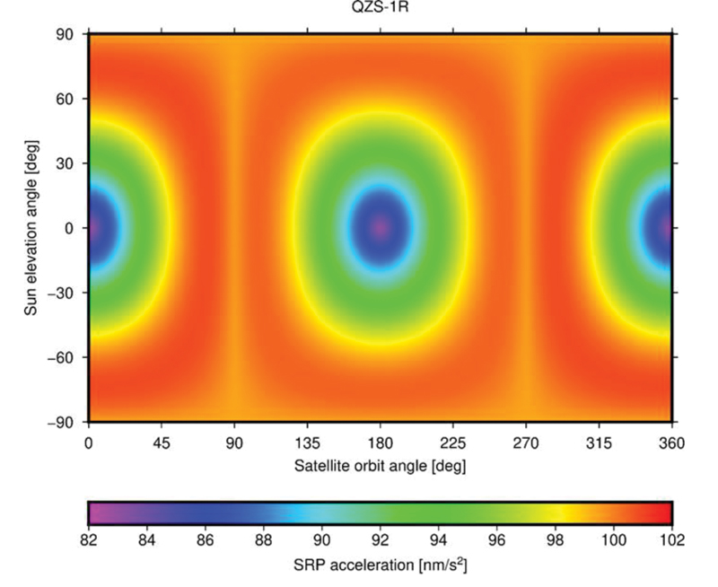
FIGURE 1 ESA’s Solar Radiation Pressure (SRP) model output in satellite-Sun frame.
The benefits of this collaboration extend beyond the agencies to the entire scientific community. Notable achievements include the revision of metadata for the QZSS constellation, such as the optical properties of the QZS-1 solar arrays, which have been refined and improved through shared expertise, while simultaneously releasing the satellite mass and attitude mode history in a machine-readable file format for easy access and adoption by the users.
To evaluate the spacecraft models and metadata for QZS-1R prior to their public release, ESA and JAXA conducted several comparative tests. Since both organizations use different software packages for satellite POD — ESA uses NAPEOS (Dow, Springer 2009, Enderle et al., 2019 and 2022) and JAXA uses MADOCA (Kawate et al., 2023) — their results can be considered as largely independent. One comparison involved the Solar Radiation Pressure (SRP) model results produced by both organizations. FIGURE 1 shows the accelerations in satellite-Sun frame computed by ESA’s SRP model. The comparison of the computed SRP accelerations in different reference frames, spacecraft-fixed and inertial, showed excellent agreement with differences of less than 0.1 nm/s².
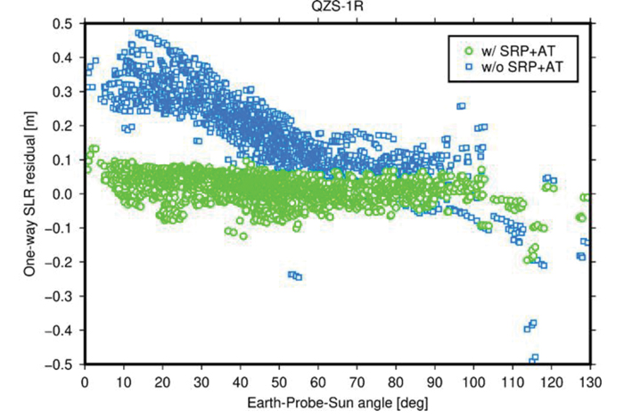
FIGURE 2 One-way Satellite Laser Ranging (SLR) range residuals calculated with respect to QZS- 1R orbits generated with (green) and without (blue) a-priori radiation force models and displayed as function of the Earth-Probe-Sun angle.
In addition, pseudo-range and carrier phase dual-frequency measurement data from 200 tracking stations of the International GNSS Service (IGS) network were used to generate precise QZS-1R satellite orbits and clock offsets on a day-to-day basis over a 12-month period spanning from January to December 2022. Comparison between ESA and JAXA solutions yielded a root-mean-square (RMS) agreement of 8.6 centimeters (orbit) and 0.21 nanoseconds (clock), respectively. Analysis of Satellite Laser Ranging (SLR) data from seven stations of the International Laser Ranging Service (ILRS) suggests a radial RMS accuracy of the generated orbital trajectories of about 4 cm. Without applying the analytical models for SRP and other non-gravitational perturbation forces, such as antenna thrust (AT), the RMS accuracy decreases by a factor of five (FIGURE 2).
In conclusion, the ESA-JAXA collaboration on Japanese Quasi-Zenith Satellite System POD has been a resounding success. Through this continuous and mutual support, performance cross-validation and knowledge sharing, significant improvements related to modeling and subsequently to POD accuracy could be achieved for ESA as well as for JAXA. Additionally, the global scientific community benefitted from this ESA/JAXA collaboration via improved QZSS POD products and validated metadata.
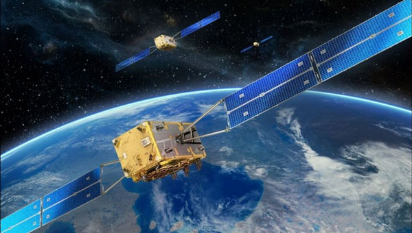
The European Space Agency (ESA) has initiated two navigation missions, Genesis and low-Earth-orbit positioning, navigation and timing (LEO-PNT) as part of its FutureNAV program. ESA has awarded contracts, totaling €233 million, to several European entities to begin the development of the missions. They are designed to address the growing demand for more resilient and precise navigation solutions in Europe.
Genesis, with a contract value of €76.6 million, involves a consortium led by OHB Italia, tasked with the development and operation of the Genesis satellite and its payloads, supported by contributions from Italy, Belgium, France, Switzerland, Hungary and the UK. The satellite is expected to launch in 2028, with subsequent years dedicated to scientific exploitation. Genesis aims to significantly improve the International Terrestrial Reference Frame (ITRF) and offer unprecedented precision for navigation and a myriad of Earth sciences applications.
For the LEO-PNT mission, ESA has distributed €78.4 million for each of the two contracts for the development of in-orbit demonstrators. These LEO-PNT satellites will explore new signals and frequency bands, designed to provide enhanced resilience, accuracy and speed in navigation. The projects are led by GMV Aerospace and Defense and Thales Alenia Space France and involve a broad consortium of more than 50 entities from 14 countries. The first LEO-PNT satellite is expected to launch within 20 months from the project’s commencement, with the complete constellation operational before 2027.
LEO-PNT satellite. (Image: ESA)
Genesis is designed as a flying observatory to refine the ITRF to an accuracy of 1 mm and a stability of 0.1 mm/year, serving as a crucial reference for all space- and ground-based observations. This enhanced reference frame is designed to directly benefit satellite-based systems and applications across various sectors, including aviation, traffic management and autonomous vehicles. It is intended to have have broader implications for meteorology, natural hazard prediction and climate change monitoring.
The LEO-PNT mission aims to establish a small constellation of demonstration satellites to test novel navigation signals and interoperability with GNSS to offer improved signal robustness and extended navigation services to challenging environments such as deep urban areas and indoors. This mission will explore the potential of LEO constellations in supporting a wide range of applications, from transportation and critical infrastructure to mobile devices and asset tracking using advancements in communication standards, such as 5G/6G.
Artist impression; size of debris exaggerated as compared to Earth. (Image: ESA)
So much going on up there!
On Jan.11, speaking at a press briefing in Paris, Javier Benedicto, director of navigation for the European Space Agency (ESA), announced the agency had completed the procurement process for the low-Earth Orbit Positioning Navigation and Timing (LEO PNT) program. ESA expects to have the new LEO PNT demonstration satellites, which will broadcast signals over several frequency bands, up and running by 2026. A positive outcome will most likely lead to the procurement and deployment of a full European LEO PNT constellation for global services.
Also in January, news broke that Google and two of the largest mobile network operators in the world, AT&T and Vodafone, had invested more than $200 million in AST SpaceMobile’s cellular broadband network based on LEO satellites and accessible directly by smartphones. AST SpaceMobile already operates the largest-ever commercial communications array in LEO, the BlueWalker 3 satellite, which, due to its size and brightness, is alarming astronomers.
On Feb. 21, The New York Times reported about U.S. warnings to its allies that Russia might deploy a nuclear weapon in orbit this year. According to the paper, U.S. intelligence agencies told their closest European allies that, “if Russia is going to launch a nuclear weapon into orbit, it will probably do so this year — but that it might instead launch a harmless ‘dummy’ warhead into orbit to leave the West guessing about its capabilities.” A space weapon nested inside a satellite could destroy, jam, or otherwise disable dozens or hundreds of commercial and military satellites in LEO, such as the Starlink satellites that are revolutionizing global communications. See Dana Goward’s analysis.
The next day, Tim Crain, chief technology officer of the Houston-based company Intuitive Machines announced, “Houston, Odysseus has found its new home.” For the first time since Apollo 17 in 1972, a U.S.-built spacecraft had landed on the moon. Odysseus, described by the Times as “a bit bigger than a telephone booth,” (which most people under the age of 20 have never seen), was later confirmed to be upright and sending images. It was delivered into lunar orbit by a SpaceX rocket. NASA hopes this mission will help inaugurate a new era of economical spaceflights around the solar system. Intuitive Machines is one of several small companies the agency has hired to transport instruments to reconnoiter the surface of Earth’s only natural satellite in preparation for the return of NASA astronauts.
My highly synthetic description of the Federal Aviation Administration (FAA) aircraft tracking systems in last month’s First Fix was a bit muddled. Fortunately, I can count on our Editorial Advisory Board member Mitch Narins to clarify:
FAA systems determine an aircraft’s position using a combination of independent and dependent surveillance. Independent surveillance does not require the “cooperation” of the aircraft (e.g., primary radar), while dependent surveillance requires the aircraft to either respond to an interrogation signal or periodically transmit its position — e.g., Automatic Dependent Surveillance-broadcast (ADS-B).
The European Space Agency (ESA) and the European Commission’s Joint Research Centre (JRC) are collaborating to host the 15th edition of the International Summer School on Global Navigation Satellite Systems (GNSS).
The course is scheduled to take place in Novo Mesto, Slovenia, from July 15 to 26, 2024.
The summer school invites graduate students, Ph.D. candidates, postdoctoral researchers, engineers and academics from both the industry and agencies to attend. The wide range of attendees offers a dynamic environment conducive to learning and networking.
The deadline for registration is June 15. Those who register by April 15 will be offered reduced fees. Additionally, the ESA Education Office is offering up to four scholarships.
The comprehensive curriculum of the summer school encompasses all aspects of GNSS, starting from the fundamental principles of satellite navigation to recent advancements in positioning, navigation and timing services.
Participants will have the opportunity to learn from world-leading experts in the field, including ESA Director of Navigation, Javier Benedicto, former ESA Director General, Jean-Jacques Dordain and former ESA Director of Navigation, Paul Verhoef.
“Seen & Heard” is a monthly feature of GPS World magazine, traveling the world to capture interesting and unusual news stories involving the GNSS/PNT industry.
Photo: NOAA Ocean Exploration
Exploring the Largest Deep-Sea Coral Reef
Scientists have mapped the largest deep-sea coral reef, stretching hundreds of miles off the U.S. Atlantic Coast. While researchers have known since the 1960s that some corals were present off the Atlantic Coast, the reef’s size remained a mystery until new underwater mapping technology made it possible to construct 3D images of the ocean floor. The National Oceanic and Atmospheric Administration (NOAA) and a team of scientists recently published maps of the reef in the journal Geomatics. The reef extends for about 310 miles from Florida to South Carolina. The total area is nearly three times the size of Yellowstone National Park.
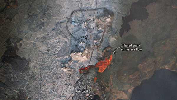
Photo: ESA
Lava in Iceland
Grindavík, a tiny town in Iceland, stands on the brink of volcanic lava flow in images captured by the European Space Agency (ESA). The lava originates beneath the Svartsengi volcano system — roughly 2.5 miles north of the town — which erupted on December 18 and January 14. ESA’s Sentinel2 satellite revealed the glow of the lava flow’s heat, not far from houses and other infrastructure within Grindavík. The town, with just 3,800 residents, has faced constant evacuations, as well as mini-earthquakes as a result, The Guardian reported.
Photo: Maris Maskalans / iStock / Getty Images Plus / Getty Images
Lidar Reveals Lost Cities in the Amazon
In the Amazon rainforest, archeologists have discovered a vast and highly complex system of ancient cities dating back nearly 3,000 years. Located in Ecuador’s Upano Valley, the structures lie in the eastern foothills of the Andes mountains, according to a study published in the journal Science. After more than 20 years of research, the ancient urban centers were only discovered when the Ecuadorean government employed lidar technology. Researchers from France, Germany, Ecuador and Puerto Rico conducted a lidar survey that covered roughly 300 km2, which revealed a landscape full of organized human activities, including more than 6,000 rectangular earthen platforms, as well as agricultural terraces and drainage systems. According to the study, these structures formed at least 15 distinct settlements, which were connected by a system of wide, straight roads.
Australian scientists are attempting to track 1,000 cattle and buffalo using artificial intelligence (AI), and GPS satellites, reported euronews.next. An estimated 22,000 cattle and buffalo roam free in a remote area of Arnhem Land, Australia, though the exact number is unknown. Scientists are now collaborating with stockmen and indigenous rangers in a four-year program that involves monitoring feral animals from space. Titled SpaceCows, the remote herd management system is backed by the Australian government’s Smart Farming Partnership initiative. Local rangers and stockmen are chasing and catching animals to attach solar-powered tags with GPS receivers.
The Korea Augmentation Satellite System (KASS), designed and implemented by Thales Alenia Space, has been officially certified by Korean national authorities and has entered operational service. The system was developed in partnership with the Korea Aerospace Research Institute (KARI) on behalf of the Korean Ministry of Land, Infrastructure and Transport (MOLIT).
The project has received support from various international and European entities, including the European Commission, the European Union Agency for the Space Programme (EUSPA), the European Space Agency (ESA), the European Aviation Safety Agency (EASA) and the French Space Agency (CNES).
KASS, operational via the MEASAT-3d geostationary satellite launched in 2022, will soon be enhanced by the addition of KOREASAT 6A. It is currently under development by Thales Alenia Space for KT SAT Corporation, South Korea’s leading satellite communications operator.
The addition of KOREASAT 6A — equipped with a satellite-based augmentation system (SBAS) payload by Thales Alenia Space — aims to improve the system’s service continuity and operational availability.
Designed to meet international standards set by the International Civil Aviation Organization (ICAO), KASS will initially prioritize aircraft applications and focus on Safety of Life services critical during flight phases, including landing. This focus is intended to enhance flight safety and efficiency while minimizing the environmental impact of aviation. Additionally, KASS is designed to be interoperable with other SBAS satellite navigation systems worldwide to offer seamless flight safety across different zones.
KASS, the second SBAS system developed by Thales Alenia Space following EGNOS (the European Geostationary Navigation Overlay System), is designed to optimize GPS constellation performance and includes upgrades compatible with the Galileo and Korean Positioning System (KPS) constellations. By enhancing the integrity, availability, continuity of services and positioning accuracy, KASS aims to reduce GPS positioning errors from the current 15 to 33 m to approximately 1 m across Korea.
Future expansions of the KASS services are anticipated to include public safety, road transport, shipping, and scientific applications.
Representatives from organizations involved in the UK Sovereign Satellite Based Augmentation System. (Image: Viasat)
Viasat, a global communications company, has successfully demonstrated the UK Satellite-Based Augmentation System (UK SBAS) during a recent test flight. This demonstration, conducted as part of an ongoing trial funded by the Department for Transport through the European Space Agency (ESA), showcased the potential of UK SBAS to provide accurate GPS data to improve safety and operational efficiency.
“The trial on a sovereign UK SBAS is all about delivering trust. Trust for pilots in their tracking systems to stay safe in challenging conditions. Trust for the aviation industry more broadly so it can rely on data to operate more efficiently,” said Todd McDonnell, president, international government, Viasat.
The test flight, carried out from Cranfield Airport using the National Flying Laboratory Centre’s Saab 340B aircraft, demonstrated the capabilities of a UK-based SBAS to deliver more precise and reliable navigation data. With the UK no longer part of the EU’s European Geostationary Navigation Overlay Service (EGNOS), the trial aims to pave the way for a complementary UK SBAS, specifically designed for critical safety-of-life navigation services across air, land and sea.
UK SBAS operates by merging ground monitoring data with satellite connectivity, which offers positioning accuracy down to a few centimeters. The system aims to significantly enhance safety in aviation by providing pilots with confidence in their onboard instruments, particularly during challenging weather conditions where visibility may be limited.
The successful aviation test marks a crucial step in further trials across various transport applications, including rail, unmanned aerial vehicles, and autonomous road vehicles, said Viasat.
Fully funded by the government through ESA’s Navigation Innovation and Support Program (NAVISP) program, the trial aligns with broader efforts to deliver high-accuracy, high-integrity positioning services to boost efficiency and innovation across the transport network.
GMV and Astroscale UK are collaborating on a new project under the European Space Agency (ESA) collision risk and automated mitigation (CREAM) program. The project aims to transform satellite collision avoidance by using Galileo Signal-in-Space (SiS) capabilities.
As low-Earth orbits (LEO) become increasingly congested, satellite operators face difficulties efficiently carrying out collision avoidance maneuvers. In response, the ESA launched the project to explore alternative paths for late collision avoidance maneuvers. The collaboration uses the Galileo Return Link Service to improve the way satellites respond to collision risks.
Traditionally, communication with satellites for collision avoidance maneuvers has been constrained by the limited availability of ground station access. This limitation forces satellite operators to delay crucial avoidance maneuvers while relying on the final passes of ground stations.
GMV’s solution offers an alternative pathway for late maneuver commanding, designed to reduce the wait time for initiating collision avoidance. The initiative proposes a continuous and reliable communication path by using the Galileo, SiS and its Return Link Service. This approach allows for the seamless relay of collision avoidance maneuver decisions to satellites equipped with onboard Galileo-compatible GNSS receivers.
The Galileo system in this role also opens the door to potential synergy with other space situational awareness (SSA) services, such as the European Space Surveillance and Tracking (EU SST). According to GMV, this strategic collaboration could potentially set the foundation for a globally available collision avoidance service.
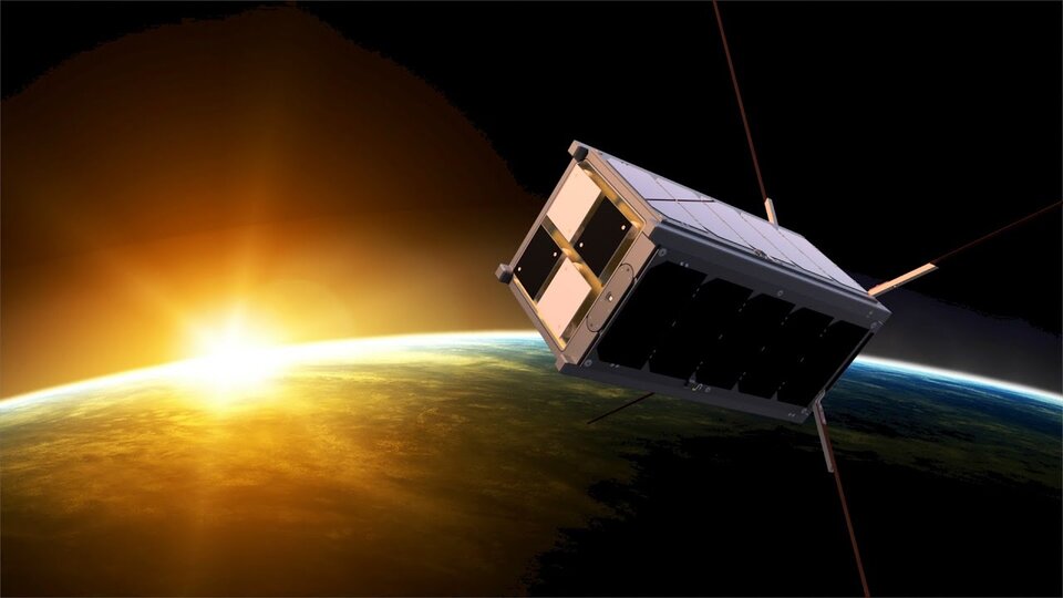
The Educational Irish Research Satellite, EIRSAT-1, has successfully launched from Vandenberg Space Force Base, California, on Dec. 1, 2023. Hitching a ride on a SpaceX Falcon 9 launcher, the small satellite has made history as Ireland’s first satellite.
Over the course of six years, EIRSAT-1 was designed, built and tested by students from University College Dublin (UCD) in Dublin, Ireland, participating in the European Space Agency (ESA) Academy’s Fly Your Satellite Program. The program is a hands-on initiative that helps university student teams develop their own satellites according to professional standards. The launch opportunity itself was provided by the ESA.
Throughout the development of the satellite, ESA experts provided training and guidance to dozens of UCD students, the ESA said. The students’ learning journey included test campaigns at ESA Education’s CubeSat Support Facility in Belgium, as well as dedicated spacecraft communications sessions at both ESA Academy’s Training and Learning Centre and the European Space Operations Centre in Darmstadt, Germany. These sessions were designed to teach the procedures for operating Ireland’s first spacecraft.
From low-Earth-orbit (LEO), EIRSAT-1 will carry out three main experiments, which were built from scratch by the students:
GMOD, a detector to study gamma ray bursts, which are the most luminous explosions in the universe and occur when a massive star dies or two stars collide.
EMOD, an experiment to see how a thermal treatment protects the surface of a satellite when in space.
WBC, an experiment to test a new method of using Earth’s magnetic field to change a satellite’s orientation in space.
Following EIRSAT-1’s deployment to orbit, the student team is now working to establish contact with the satellite and start operations from their dedicated ground control facility, also entirely operated by students and located at UCD in Dublin.