The European Space Agency (ESA) Academy is requesting university students to apply for the pilot edition of the Navigation Training Course. The course will take place June 26-30 at ESA Academy’s Training and Learning Facility in ESEC-Galaxia, Belgium.
With a specific focus on Galileo, the ESA Academy course aims to provide university students with an introduction to satellite navigation. Designed by ESA experts that developed the Galileo space and ground segment, this training course will offer students fundamental knowledge of Galileo’s architecture, tools, services and functionalities.
The training course will include lectures and hands-on exercises with a tour of Galileo in-orbit test facilities in ESEC, which provides an essential part of the current Galileo ground segment.
Upon completion of the training course, students will be evaluated and will receive a certificate of participation and course transcript, allowing them to request ECTS credits from their respective universities.
For more information and application requirements, visit the ESA website.
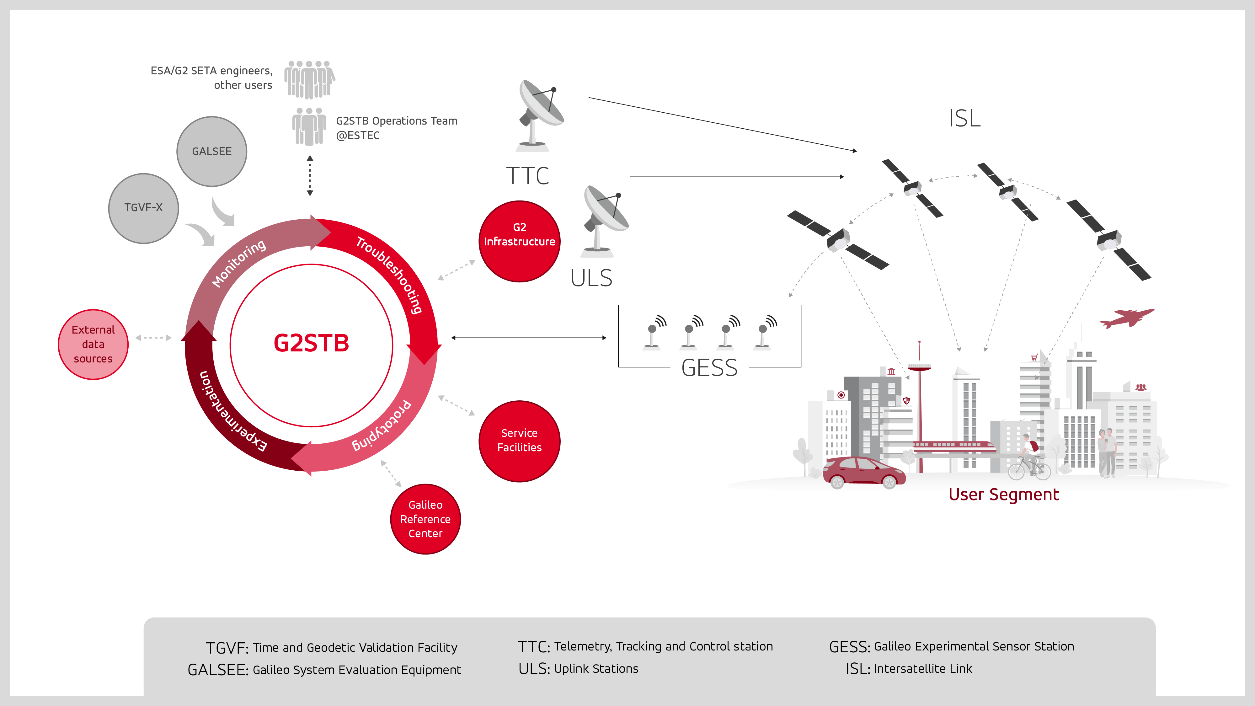
GMV has been selected by the European Space Agency (ESA) and the European Union Agency for the Space Programme (EUSPA) to develop the Galileo second-generation system test bed (G2STB). The G2STB will provide ESA with a key system verification and validation facility in support of its role as Galileo system development prime, enabling a wide range of Galileo system monitoring, troubleshooting, prototyping and experimentation activities.
GMV will deliver four G2STB versions over five years. Among these modules, the G2 high accuracy service (HAS) data generator and monitor aims to improve the Galileo HAS that was declared operational in January.
Other early capabilities of the G2STB include an upgraded orbit determination and time synchronization facility — capable of processing inter-satellite link data, a time service monitoring module, an integrity support message generator, a signal authentication service, an authentication validation module, an emergency warning service module, an ISL simulator and a G2G message composer.
The G2STB project aims for a smooth transition from the Galileo first-generation to the second-generation, building onto the G1G legacy system tools. The G2STB is one of the key infrastructure elements that ESA is developing for the correct functioning of the Galileo second-generation satellites.
The G2STB will eventually replace and upgrade the capabilities of the two first-generation facilities, the Galileo system evaluation equipment and the time and geodetic validation facility (TGVF-X). The latter, developed and operated by GMV over the last decade, has played a key role in monitoring the Galileo signals and system validation activities during the Galileo exploitation phase. The TGVF-X is also contributing to the early validation of new capabilities and elements being rolled out in recent and upcoming Galileo System updates.
In parallel to the development phase, the G2STB will help upgrade the network of Galileo experimental sensor stations to process new signals and capabilities to ensure the availability of a G2-capable, worldwide, multi-constellation network of receivers and bit-grabbers — independent from the operational Galileo sensor stations.
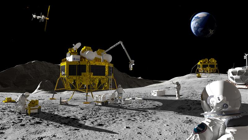
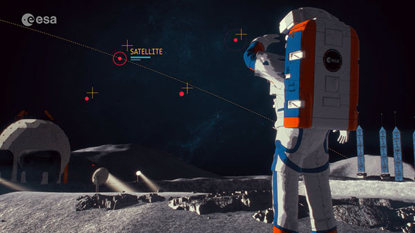
An artist’s impression of a Moon exploration scenario. (Image: ESA)
As there are several missions to the moon planned within the next decade, space agencies have started to consider how to keep time on the moon. To address time concerns, the LunaNet architecture, designed for lunar communications and navigation services, was introduced at the ESTEC technology center of the European Space Agency (ESA) in the Netherlands in November 2022.
“LunaNet is a framework of mutually agreed-upon standards, protocols and interface requirements allowing future lunar missions to work together, conceptually similar to what we did on Earth for joint use of GPS and Galileo,” said Javier Ventura-Trav
eset, ESA’s Moonlight navigation manager, coordinating ESA contributions to LunaNet. “Now, in the lunar context, we have the opportunity to agree on our interoperability approach from the very beginning, before the systems are actually implemented.”
“During this meeting at ESTEC, we agreed on the importance and urgency of defining a common lunar reference time, which is internationally accepted and towards which all lunar system and users may refer,” said Pietro Giordano, ESA navigation system engineer. “A joint international effort is now being launched towards achieving this.”
Each mission to the moon has operated on its own timescale from Earth. Deep space antennas have been used to keep onboard chronometers synchronized with terrestrial time at the same time to facilitate two-way communications. ESA stated that this way of working will not be sustainable in the coming lunar environment.
Time to think about time
Should a single organization be responsible for setting and maintaining lunar time? Also, should lunar time be set on an independent basis on the moon or kept synchronized with Earth? And what about time on other planets?
“Of course, the agreed time system will also have to be practical for astronauts,” said Bernhard Hufenbach, a member of the Moonlight Management Team from ESA’s Directorate of Human and Robotic Exploration. “This will be quite a challenge on a planetary surface where in the equatorial region each day is 29.5 Earth days long, including freezing fortnight-long lunar nights, with the whole of Earth just a small blue circle in the dark sky. However, having established a working time system for the moon, we can go on to do the same for other planetary destinations.”
To efficiently collaborate, the international community will have to settle on a common “selenocentric reference frame,” similar to the role played on Earth by the International Terrestrial Reference Frame, allowing the consistent measurement of precise distances between points across the planet.
The European Space Agency (ESA), in collaboration with the Joint Research Centre of the European Commission, are hosting this year’s ESA/JRC International Summer School on GNSS with the Swedish Space Agency in July in Kiruna, Sweden. The course will include an overview of satellite navigation from the theoretical basis of GNSS, their signals, and processing by receivers and more.
Elements of this year’s program will include details of low-Earth-orbit positioning, navigation and timing, navigation on the Moon, and Galileo’s Open Service Navigation Message Authentication. Exercises will include receiving signals from Galileo and other GNSS.
Participants will also learn about business aspects, intellectual property rights, and the future of satellite navigation systems, including Galileo second-generation.
Some of the world’s leading satnav and space experts will be giving lectures. Lecturers include Paul Verhoef, former director of navigation for ESA, and Jean-Jacques Dordain, former director general. The course will be opened by Anna Rathsman, Director General of the Swedish National Space Agency; Javier Benedicto, Director of Navigation at the European Space Agency; and Georgios Giannopoulos, head of the Technologies for Space, Security and Connectivity Unit at the Joint Research Centre of the European Commission.
The course is limited to 50 participants on a first-come, first-served basis and is open to graduate students, Ph.D. and postdoctoral researchers, as well as young engineers and academics working within industry or agencies, aged 38 or younger.
The summer school will take place July 17-28 in Kiruna, Sweden. Register before April 14 for a reduced early fee. For more information and to register, click here.
The high-accuracy service (HAS) offered by Galileo is now available and provides sub-meter accuracy over most of the globe. It will help enable emerging technologies such as UAVs and autonomous vehicles, which require stringent levels of accuracy for better navigation, safety and efficient traffic management.
Other industries expected to benefit include transportation, agriculture, geodesy and entertainment.
Thierry Breton, European commissioner for Internal Market, announced that the service was now live during the annual European Space Conference in Brussels, Belgium, on Jan. 24.
The European Union Agency for the Space Programme (EUSPA) developed Galileo HAS along with the European Commission and the European Space Agency (ESA). The new service will become a pillar of government programs such as EU sectorial policies and national policies by EU Member States.
“This new service has been made possible thanks to the outstanding cooperation and team commitment of all involved partners,” said Rodrigo da Costa, EUSPA executive director.
“Galileo is not standing still,” said Javier Benedicto, ESA director of navigation. “This new High Accuracy Service offers a new dimension of precision to everyone who needs it, while the Open Service Navigation Message Authentication — already available — allows users to authenticate Galileo signals as they make use of it, to minimize any risk of spoofing. An upgraded integrity message of the signal rolled out last year reduces the time to first fix while enhancing the overall robustness of Galileo.”
Galileo HAS delivers horizontal accuracy down to 20 cm and vertical accuracy of 40 cm in nominal use conditions, according to ESA. The service is transmitted directly via the Galileo signal in space (E6-B) and through the internet.
With HAS, Galileo becomes the first constellation worldwide able to provide a high-accuracy service globally and directly through the signal in space.
The service is freely accessible to all users with a receiver capable of processing the HAS corrections broadcast in the E6-B signal and via the internet. The precise corrections provided by Galileo HAS will allow users to reduce the error associated with the orbit and clocks provided through the Galileo Open Service broadcast navigation messages and the GPS Standard Positioning Service navigation data.
“With the Galileo HAS we are ready to unleash the full potential of new technologies such as drones and bring autonomous driving closer to reality,’’ da Costa said. “At EUSPA, our role is to link space to user needs. With the launch of this new service, we met a clear market demand for accurate, robust, and reliable navigation.”
MGISS, a United Kingdom-based geospatial technology company, has launched the Interruption Prevention Alert Service (IPAS) project to help minimize disruptions to gas and water supplies in the UK. The European Space Agency (ESA) has partly funded this project, which will run for two years to test its technical and commercial viability and to develop a go-to-market plan.
As gas and water outages caused by construction are a growing problem in the UK, IPAS will offer a preventative solution. By leveraging satellite data and services, IPAS will automatically detect changes to the built environment and alert utility providers. The IPAS is expected to be a cost-effective solution and help utility providers reduce carbon emissions.
MGISS is collaborating on this project with Geospatial Insight, its data partner, Northumbrian Water Group (NWG) and Northern Gas Networks (NGN), its client partners, and funding partners including the ESA and the UK Space Agency (UKSA).
The launch of the pilot project is the result of a joint workshop with ESA and NWG’s 2020 Innovation Festival, and two years of ongoing collaboration with NWG and NGN.
Image: Vincent Ryan/iStock/Getty Images Plus/Getty Images
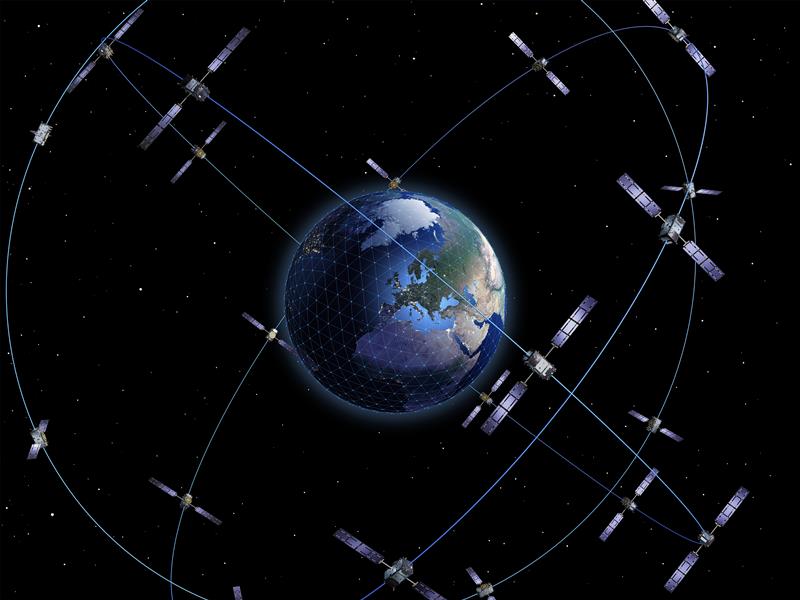
On Nov. 11, the last Galileo satellite of first-generation series was shipped from ESA’s ESTEC Test Centre, Europe’s largest satellite testing facility. Galileo is Europe’s largest satellite constellation and one of the most accurate satnav systems in the world.
Galileo’s development began two decades ago with two test GIOVE satellites, followed by a series of other operational launches to add to the constellation. The current constellation consists of 34 Full Operational Capability satellites, the initial two GIOVE satellites, and the Galileo In-Orbit Validation satellite. Galileo Second Generation satellites are already in development.
On Nov. 18, the European Space Agency (ESA) announced a Navigation Innovation and Support Programme (NAVISP) partnership with Italy’s Grimaldi Group, as the need for accurate maritime navigation increases. With the Grimaldi Group, NAVISP has taken on the Grimaldi Satellite-Assisted Berthing (GSAB) project, which aims to develop a satellite-based guidance system for docking maneuvers of large vessels.
NAVISP’s GSAB project will use satellite-based multi-sensor technology to improve the efficiency of maneuvers in ports to increase safety while also reducing CO2 emissions. Maritime navigation is too complex for GPS and Galileo alone, so, by fusing those two systems with PNT sensors, the project can achieve its intended outcome.
The project is divided into two phases. In the first phase, NAVISP is working on design, development activities, installation of the sensors in a roll-on, roll-off vessel, and running a test readiness campaign. The second phase includes field tests with the equipped ship in the Grimaldi facilities in the Port of Antwerp-Bruges, Europe’s second largest seaport.
Shipping transport is responsible for more than 80% of goods traded globally, and the Grimaldi Group is one of the largest shipping companies globally with more than 130 ships. As the need for efficient and safe ship transport in and out of ports grows, NAVISP continues to support innovation to improve satellite navigation and positioning systems in the maritime sector, according to ESA.
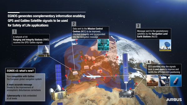
On Dec. 7, the European Geostationary Navigation Overlay Service (EGNOS) V3, a satellite-based navigation augmentation system designed by Airbus, passed the System Critical Design Review (CDR). EGNOS V3 supports safety-critical aircraft applications and will soon provide services to maritime and land users.
New services provided by EGNOS V3 are based on multiple frequencies from GPS and Galileo constellations and will provide protection against cyberattacks. As it successfully passed CDR, this multi-constellation and multi-frequency satellite-based navigation augmentation system is a step forward in improving EGNOS accuracy, robustness, and overall coverage in Europe.
EGNOS V3 relies on three operation centers and 44 monitoring stations across Europe. It monitors the signals from satellite navigation systems and generates augmentation messages broadcast to all users using transponders and geostationary satellites. Airbus is currently designing more Galileo satellites, which will further improve EGNOS accuracy and robustness and the resilience of its signal.
EGNOS is a component of the European Union Space Program and is managed in partnership with the European Commission’s Directorate-General for Defense, Industry and Space, the European Union Agency for the Space Programme (EUSPA) and the European Space Agency (ESA).
The 2023 European Navigation Conference (ENC) will take place May 31-June 2 with a focus on resilient navigation. This conference, which will welcome professionals from the positioning, navigation, and timing (PNT) field, is organized by the Netherlands Institute of Navigation, a member of the European Group of Institutes of Navigation (EUGIN).
Given the growing vulnerability of satellite-based position and timing, the conference will focus on resiliency, which requires redundancy in the signal domain, terrestrial and space infrastructures, and on-board implementation — as well as addressing vulnerabilities in navigation functions, data, and guidance control.
Thanks to the hospitality of the European Space Agency, the ENC will be held at the ESTEC site in Noordwijk, The Netherlands, where the Galileo satellite system is designed and where navigation satellites are tested before launching.
The Ministerial Council of the member states of the European Space Agency (ESA) has pledged 351 million euros to ESA’s board of directors for navigation to aid in multiple satellite navigation endeavors.
This funding helps support ESA’s FutureNAV program, the Navigation Innovation and Support Program (NAVISP), and the Moonlight Initiative, developed for lunar telecommunications and navigation coverage and innovation.
The FutureNAV program is aimed at addressing the rapidly growing need for more ubiquitous, resilient and reliable positioning, navigation and timing (PNT). Its first mission consists of an initial in-orbit demonstration, small constellation of low-Earth-orbit (LEO) navigation satellites. The LEO-PNT satellites will test a multi-layer approach to deliver more accurate and robust PNT services, supplementing Galileo.
The second FutureNAV mission, GENESIS, will map the moving contours of Earth, while enhancing the accuracy of Galileo.
The expanded funding will also be invested in NAVISP. The program has already began working on over 200 projects relating to satellite navigation, PNT research, and backing Member States in research priorities.
Lastly, funding is being delegated to the Moonlight Initiative, a project designed by ESA to extend satellite navigation and telecommunications coverage to the Moon. The advancement and launch of Moonlight infrastructure on the Moon will undertake several missions bolstering future Moon exploration.
The European Space Agency (ESA) has released a new video describing the Moonlight Initiative, part of NASA’s Artemis program.
ESA is a key partner in Artemis, which aims to return people to the Moon by the end of decade. Dozens of other international public and private missions are setting their sights on the lunar surface in the coming years.
However, to achieve a permanent and sustainable presence on the Moon, reliable and autonomous lunar communications and navigation services are required. ESA is working with industrial partners on the Moonlight Initiative, to become the first off-planet commercial telecoms and satellite navigation provider.
After launch, three or four satellites will be carried into lunar orbit by a space tug, and deployed one by one to form a constellation of lunar satellites. The number and specification of these satellites are being defined.
The constellation’s orbits are optimized to give coverage to the lunar south pole, where sustained sunlight and polar ice make it the focus of upcoming missions.
Moonlight will provide data capacities sufficient to serve these planned and future missions, with a navigation service that enables accurate real-time positioning for all lunar missions.