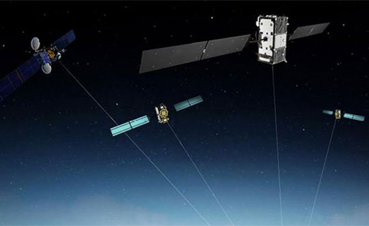
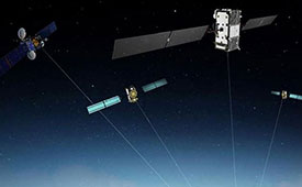
A Eutelsat communications satellite launched Oct. 9 carried a payload for the European GNSS Agency (GSA) called GEO-3. GEO-3 is a geostationary satellite designed to augment GNSS signals.
The EGNOS payload, manufactured by Airbus Defence and Space, will hone the accuracy of satellite navigation signals over Europe for use in aviation, maritime and other industries as part of the European Geostationary Navigation Overlay System (EGNOS).
The Eutelsat-5 West B satellite also hosts a payload that will enable service continuity for television broadcasting in Europe and North Africa.
The GSA signed a contract in March 2017 with Eutelsat Communications for the development, integration and operation of the next-generation GEO-3 EGNOS payload.
EGNOS operational messages are broadcast via navigation payloads on-board two GEO satellites, including an Inmarsat-3F2 satellite that is fast approaching end-of-life. The GEO-3 services replenish the EGNOS SBAS payloads, guaranteeing EGNOS availability and supporting the transition to the dual-frequency multi-constellation-capable EGNOS V3.
Eutelsat will also develop two redundant RF ground stations to uplink the EGNOS message to the payload. It will also host EGNOS’ Navigation Land Earth Stations (NLES) in Rambouillet, France, and Cagliari, Italy, both of which will be co-located and connected to the RF ground stations.
Proton-powered launch
The satellite was carried aloft on a Proton rocket along with a second satellite, the Mission Extension Vehicle-1 for Northrop Grumman subsidiary SpaceLogistics, designed to service satellites. Both spacecraft were built by Northrop Grumman.
The Proton rocket lifted off at 6:18 a.m. Eastern Time from Russia’s Baikonur Cosmodrome in Kazakhstan. Its two passengers separated from the rocket 16 hours later in a supersynchronous transfer orbit.
Eutelsat-5 West B is a replacement for the 17-year-old Eutelsat-5 West A satellite.
The estimated number of Galileo-enabled smartphones in use has reached one billion. This significant milestone has been achieved in the week when the European GNSS Agency (GSA), responsible for operation of the Galileo programme, celebrates its 15th anniversary.
The company BQ pioneered Galileo use in smartphones with its Aquaris X5 Plus in July 2016. Since then, market uptake of Galileo-enabled smartphones has been rapid as other manufacturers were quick to embrace the opportunities that Galileo offers.
Global annual GNSS receiver shipments are forecast to grow from 1.8 billion units in 2019 to 2.7 billion units in 2029.
Currently, 156 Galileo-enabled smartphone models available on the market. The “1 billion users” milestone is based on the number of smartphones using Galileo sold across the world. The actual number of Galileo users around the world is much larger. You can track which devices, including smartphones, are Galileo-enabled on the UseGalileo.eu site.
Today, 95% of companies that produce smartphone chips for satellite navigation make chips that enable Galileo. According to figures in the latest GSA GNSS Market Report, which is to be published soon, global annual GNSS receiver shipments are forecast to grow continuously across the next decade, from 1.8 billion units in 2019 to 2.7 billion units in 2029. Most of these shipments are for receivers costing less than €5, and 90% of receivers in this price segment are used in smartphones and wearables.
The number of Galileo-enabled smartphones in use has soared to 1 billion in just 3 years. (Image: GSA)
“Galileo is now providing high quality timing and navigation services to 1 billion smartphone users globally,” said Elżbieta Bieńkowska, commissioner for Internal Market, Industry, Entrepreneurship and SMEs. “This has been made possible by a truly European effort to build the most accurate navigation system in the world, with the support and dedication of the GSA. I am confident that our space industry will continue to thrive with more work, ideas and investment under the new EU Space Programme.”
“One billion smartphone users is a significant milestone and a major achievement for the Galileo programme and for the GSA,” said GSA Executive Director Carlo des Dorides. “The GSA has worked tirelessly to build bridges with research and industry and create a strong community of service providers who trust Galileo and understand the technological innovation opportunities it brings.
“Chipset and receiver manufacturers in particular have been quick to leverage Galileo’s outstanding performance,” des Dorides said. “These manufacturers believed in Galileo from the beginning, when Galileo was still an idea, and invested in the technology. It is thanks to them and the unique blend of expertise and knowledge of the GSA team that we are now celebrating 1 billion Galileo-enabled smartphones.”
GSA Executive Director Carlo des Dorides kicks off the celebration. (Photo: GSA)
News from the European GNSS Agency
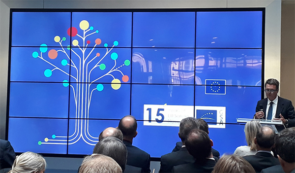
The European GNSS Agency (GSA) hosted a special event on Sept. 10 to mark the 15th anniversary of its creation. The agency was set up as the European GNSS Supervisory Authority in 2004 to oversee the development of the European space programmes EGNOS and Galileo.
GSA Executive Director Carlo des Dorides welcomed special guests to the GSA’s Prague headquarters to celebrate the event, including European Commissioner Elżbieta Bieńkowska, Czech Transport Minister Vladimir Kremlik, French Space Agency (CNES) President and GSA Administrative Board Chair Jean-Yves Le Gall and European Space Agency Director General Jan Woerner, in addition to other EGNOS and Galileo stakeholders.
“Over the last 15 years, the GSA has become one of the key players in building Europe’s independent capacity in satellite navigation,” said Commissioner Bieńkowska, responsible for Internal Market, Industry, Entrepreneurship and SMEs. While participating in the celebrations, the commissioner also presided over another historic milestone for both the Galileo programme and the GSA — the countdown to the 1 billionth Galileo-enabled smartphone sold.
“GSA has been at the heart of the EGNOS and Galileo programmes over the past 15 years.” — Carlo des Dorides.
Linking space to user needs
GSA Executive Director Carlo des Dorides said: “It is an honour and a great pleasure to celebrate this important milestone with representatives from all our stakeholders — the Commission, users, industry and other institutional bodies. Their presence here clearly shows that the GSA is delivering on its mission – linking space to user needs”.
“15 years ago, no one imagined how far the GSA and the EU satellite navigation systems EGNOS and Galileo would go. Now, no one can imagine Europe without Galileo and EGNOS, or Galileo and EGNOS without Europe. The GSA has been at the heart of these two programmes, accelerating progress in service provision, market uptake and guaranteeing operation security over the past 15 years. All that has been accomplished has been made possible thanks to the unique blend of expertise, dedication and commitment of the GSA’s staff,” des Dorides said.
Speaking at the event, GSA Administrative Board Chair Jean-Yves Le Gall said: “Today thanks to the European Union’s impressive investment, the European Space Agency’s technical expertise and the GSA’s outstanding commitment, Galileo is offering the best localization available worldwide. The range of applications is vast. This is structuring our economy and the implementation of the public policies to ensure that European companies are taking full advantage of these fantastic services.”
Czech Transport Minister Vladimir Kremlik noted the importance to the Czech capital of hosting the EU agency. “It has been fifteen years of hard work and continual development. By chance it is also seven years since the seat of GSA has been relocated from Brussels to Prague. I am very proud, that the Czech Republic is the hosting country of the seat of such an important European agency with real global reach,” the minister said.
Looking to the future
Galileo will soon reach its Full Operational Capability, a phase that will require new governance to comply with benchmarked standards for the management of operational satellite services. It was with this in mind that the European Parliament and the Council agreed on a new EU Space Programme Regulation establishing the EU Agency for the Space Programme (EUSPA) as the successor to the GSA.
“In the new governance the Commission will continue to be responsible for managing the overall programme. The GSA, to be renamed the ‘EU Agency for the Space Programme,’ will increasingly support the exploitation and market uptake of EU space activities and play an increased role in ensuring the security of all programme components. The intergovernmental European Space Agency (ESA), given its expertise, will remain a major partner in the technical implementation of the EU space programme,” des Dorides said.
To explore new investment support for the European space-based economy, the EIB and GSA are bringing together their expertise and experience. The common objective is to create high-skill jobs in the EU and improve the day-to-day lives of Europeans by supporting innovative companies and accelerating the development of new applications that use European global navigation satellite systems and earth observation data. These applications could be used to ensure smooth navigation, such as in search-and-rescue operations to save lives, for observing crops, and in precision farming to reduce the need for fertilizers and pesticides.
“Space is the final frontier, and there is a new worldwide ambition in reaching it. The EU’s global competitors and new private actors are investing heavily in the space sector. At the same time, new disruptive technologies and business models are emerging and changing the playing field,” said EIB Vice-President Ambroise Fayolle, who is responsible for innovation. “We need to make sure that Europe stays in the game. That is why we are particularly enthusiastic about this agreement with GSA. It is an important step to develop further support for European space entrepreneurs and businesses to eventually give them and the EU a competitive edge in this new space race.”
“Our expertise in market intelligence for satellite navigation and in supporting new business opportunities — thanks to EGNOS and Galileo — is the basis of our agreement with the EIB,” said Carlo des Dorides, GSA Executive Director. “We are confident that our cooperation will bring the extra added value required by entrepreneurs to transform their application businesses into globally successful companies.”
A changing space sector
The global space economy has been evolving rapidly in recent years. On average it has grown by 6.7% per year over the last 10 years, which is almost twice the 3.5% average yearly growth of the global economy. This growth has been partially driven by the US, China and other countries that have developed new ambitious space missions.
The main driver, however, has been the “New Space” phenomenon: a number of technological and business model innovations that have introduced new products and services and reduced the cost of accessing and using space.
The transformation of the space economy has seen new space companies investing over EUR 14.8 billion since 2000, with a fast accelerating trend: total investment in space companies grew by a factor of 3.5 in 2012–2017 compared with the previous six-year period. Moreover, US-based investors dominate the field accounting for around two thirds of the 400+ worldwide investors in space companies.
Historically, Europe has always been at the forefront of publicly-funded space exploration, investing massively in space infrastructures such as the Copernicus and Galileo satellite programmes. Europe still boasts academic and scientific excellence but risks missing the next wave of space innovation unless it seizes the opportunity to stimulate more private investment in the new space sector.
According to a recent EIB and European Commission study on the future of the European space sector, European space entrepreneurs feel there is a lack of private financing sources, particularly for late-stage investments. They therefore tend to keep an eye on private capital outside the EU, especially in the US.
In this context, European public innovation instruments play an essential role in unlocking private capital for the space sector. 40% of the European companies surveyed seek public funding, which serves as a seal of approval in the market, as a precondition for further private investment.
The European GNSS Agency (GSA) is looking for experts with a high level of expertise in navigation satellite systems to assist it with tasks related to the implementation of the Fundamental Elements funding mechanism.
The GSA is interested in experts with professional experience in specific market segments such as aviation, location-based services, agriculture, surveying, rail, road, maritime, and timing and synchronisation and/or with hi-tech business building skills.
Specifically, the GSA would like to involve business and technical experts with proven experience in one or more of the following areas:
E-GNSS signal processing;
Development (hardware, software/firmware algorithms etc.) of E-GNSS receivers and antennas;
Applications, services and products in the area of E-GNSS;
E-GNSS technologies state of the art boosting, particularly E-GNSS differentiators.
Experts assist in:
Evaluation of proposals, prize applications and tenders
Monitoring of actions, grant agreements, public procurement contracts
Experts also provide opinion and advise on preparation, implementation and evaluation of EU programmes and design of policies.
No deadline, but apply early
To select experts, the European Union Institutions regularly publish calls for expression of interest detailing the selection criteria, the required expertise, the description of the tasks, their duration and the conditions of remuneration.
The call for expression of interest is permanently open, so there is no application deadline. However, early application is encouraged because the first experts should be appointed in the third quarter of 2019. Anyone interested can register here.
Experts who have already registered in the Participant Portal expert database are invited to log-on here to declare their interest in Fundamental Elements assignments and to update their area(s) of expertise.
For more information and to download the call, click here.
Fundamental Elements
Fundamental Elements is an EU R&D funding mechanism supporting the development of EGNSS-enabled chipsets, receivers and antennas. Fundamental Elements projects are part of the overall European GNSS strategy for market uptake, led by the GSA. The objectives of the programme can be summarised as follows:
Facilitate the adoption of EGNSS, building on innovative services and differentiators;
Improve the competitiveness of EU industry ;
Address user needs in priority market segments ;
Maximise benefits to European citizens.
The total budget for projects to be carried out in 2015-2020 is EUR 111.5 million.
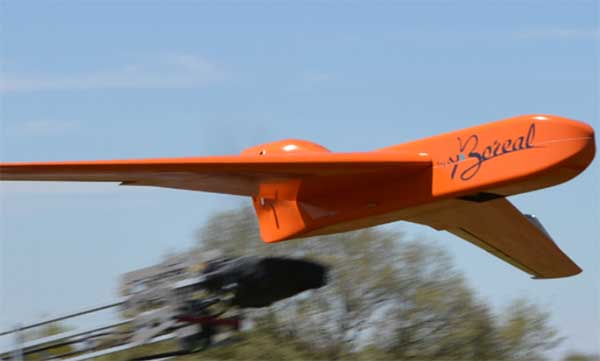
EGNSS improves positioning integrity and accuracy for the Boreal drone. (Photo: GSA)
News from the European GNSS Agency
The Skyopener project, co-financed by the European GNSS Agency (GSA), aims to pave the way toward increased use of remotely piloted aircraft system (RPAS) in civil applications.
The project has tested the benefits of multi-frequency GNSS and EGNOS in RPAS, revealing gains in availability, accuracy and robustness.
There is increasing demand to operate RPAS over long distances because of their potential for a wide range of civil applications. However, regulation regarding RPAS use in civil airspace does not yet allow beyond-visual-line-of-sight (BVLOS) operations, and remotely piloted aircraft are not allowed to fly in non-segregated civil airspace and are not yet widely used for civil and commercial applications.
This is something that Skyopener aims to change.
RPAS for civil applications. The project is developing operational processes that will reduce all categories of risks associated with RPAS and allow an air navigation service provider (ANSP) to manage very-low-level RPAS operations. Thanks to the benefits it offers in terms of improved integrity and positioning accuracy, EGNSS (Galileo and EGNOS) will play a central role in these processes.
Through these operational processes, Skyopener will contribute to the roadmap for the integration of civil RPAS into non-segregated airspace, which will have a huge impact on the service applications that can be offered by these aircraft.
“Systems that enable RPAS to fly safely, in compliance with regulations, will enable market access and significantly reduce the cost of insurance premiums for RPAS operators, making a wide range of RPAS applications more commercially attractive and widely used,” said Marc Pollina, CEO of Skyopener consortium member M3 Systems.
Excellent results. A test conducted by the project into the benefits of multi-frequency GNSS and EGNOS has delivered excellent results. The test found that the use of GPS and Galileo in L1/E1 and L5/E5 multi-frequency combinations provides improved availability, better accuracy and greater robustness against interference, as interference with one frequency band has no effect on the second.
What’s more, EGNOS helps meet increasingly stringent requirements for robust navigation, continuity, accuracy and availability — further complemented by Galileo’s multi-constellation capacity and integration with other sensors such as inertial or vision sensors.
The Boreal drone used in the project is a fixed-wing system that operates over a long range (more than 100 kilometers) in BVLOS, with EGNOS and Galileo enhancing navigation by improving positioning integrity and accuracy. In addition, the RPAS is equipped with a newly developed communication and navigation surveillance (CNS) system that combines use of GNSS, satcom and special security measures.
Essential GNSS. GNSS technologies are essential for RPAS. The primary need is obviously for navigation — the RPAS uses GNSS waypoints to follow the trajectory defined in its mission. However, GNSS also addresses other key needs, such as geofencing to ensure that the RPAS keeps within the mission parameters and surveillance to enable adequate tracking by the operator and civil aviation authority.
GNSS also enables high accuracy and, ultimately, automated landing and the geo-referencing of collected data. These benefits will increase in the future, with the Galileo authentication service reducing the risk of threats, and PPP data correction on E6 providing better geo-referencing.
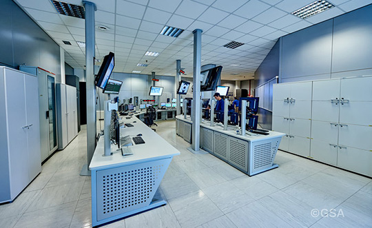
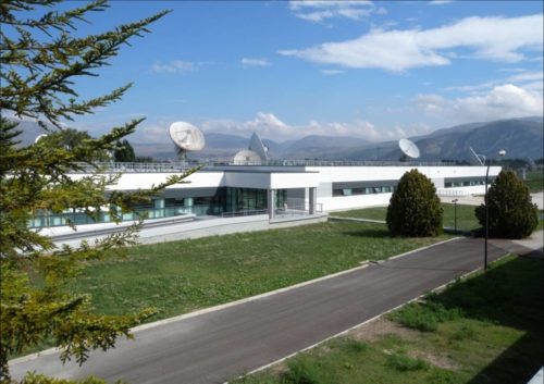
Galileo’s Control Centre in Fucino is used to oversee the satellites’ navigation payloads and services. (Photo: ESA)
Global markets learned something important from the brown-out of Galileo signals over a week’s time in July: Life goes on without a hiccup in the absence of the European GNSS.
Very unfortunately for the backers and boosters of Galileo, this message will reverberate down through the years. If vital affairs proceed unaffected by Galileo’s travails, or triumphs for that matter, who needs it? The response, a shrug. I’m tempted to say a Gallic shrug, were it not that the Gauls, the French, are prime among the system’s boosters and backers.
I’m among that number as well. Galileo and I have known each other all our lives, all our professional lives. When I started on this magazine 19 years ago, the first story I edited was on Galileo’s public-private partnership.
Galileo then was just a collective gleam in several politicians’ and scientists’ eyes. Look how far it has come: 20 satellites flying in various operational or testing states.
The European GNSS Agency was very careful to point out during the crisis that Galileo is in its initial services phase. Its signals are available for use in combination with other GNSS and are not intended to provide a complete solution by themselves. This status is expressly designed to allow for “the detection of technical issues before the system becomes fully operational.”
So, it doesn’t count. Because, the game hasn’t really started yet. Right?
Not quite.
Because this episode occurred, it will be remembered. Because it lasted so long, it will be factored. Because the official announcements about it were so obscurantist, the system may find it more difficult to regain trust.
Of course a full, careful, in-depth investigation must take place before officially announcing what caused the debacle. But more than was said could surely have been said, during the crisis. A full week now, as of this writing, after the week-long outage concluded, we still have no indication as to which piece of ground equipment or software failed and why there wasn’t a smooth transition from the Italian to the German control station.
Redundancy was built into the system to preclude exactly such failures as this. Why didn’t redundancy work?
Transparency is a rhyming word that goes well with redundancy.
Trust — corporate confidence — is fundamental to installation in multi-GNSS chips, boards, modules, all manner of devices. Four systems compete for spots at a table that may comfortably fit only three. Even three could be a stretch.
GLONASS suffered a much shorter (11-hour) timing glitch in 2014, and has yet to climb back into the public-confidence ring.
Here’s a very public lesson in transparency: When the GPS satellite SVN49 failed rather spectacularly in 2009, the GPS Directorate was very forthcoming, almost embarrassingly so, about what happened and why. GPS never lost a step in the public’s and the industry’s eyes.
Galileo Initial Services have been restored after a week-long signal outage, according to a statement released on July 18 by the European GNSS Agency (GSA).
“Commercial users can already see signs of recovery of the Galileo navigation and timing services…although some fluctuations may be experienced until further notice.”
After a signal outage that began on July 11, efforts to restore services reportedly found a malfunction in the calculation of time and orbit predictions (ephemeris).
Why the error affected both Precise Timing Facilities (PTFs) within the Galileo ground control system, at Fucino in Italy and Oberpfaffenhoffen in Germany, has not been explained. System redundancy in the form of such doubled facilities was meant to prevent such breakdowns.
The GSA statement continues:
“Galileo Initial Services have now been restored. Commercial users can already see signs of recovery of the Galileo navigation and timing services, although some fluctuations may be experienced until further notice.
“The technical incident originated by an equipment malfunction in the Galileo ground infrastructure, affecting the calculation of time and orbit predictions, and which are used to compute the navigation message. The malfunction affected different elements on the ground facilities.
“A team composed of GSA experts, industry, ESA and Commission, worked together 24/7 to address the incident. The team is monitoring the quality of Galileo services to restore Galileo timing and navigation services at their nominal levels.
“We will set an Independent Inquiry Board to identify the root causes of the major incident. This will allow the Commission, as the programme manager, together with the EU Agency GSA to draw lessons for the management of an operational system with several millions of users worldwide.”
The full statement, including links to previously issued Notice Advisories to Galileo Users (NAGUs) is available here on the GSA website.
The Galileo signal outage, ongoing since Thursday, July 11, has been attributed to a problem with the system’s ground infrastructure, according to an announcement by the European GNSS Agency (GSA). “Experts are working to restore the situation as soon as possible,” states the GSA. “An Anomaly Review Board has been immediately set up to analyze the exact root cause and to implement recovery actions.”
No update has appeared at this time as to when service will resume.
[Photo: Galileo’s Ground Mission Segment in the Fucino Control Centre in Italy oversees Galileo navigation services and satellite payload operations. Photo: Telespazio.]
The announcement points out that Galileo is currently in its initial services phase, wherein its signals are available for use in combination with other GNSS and do not provide a complete solution in and of themselves. This status is expressly designed to allow for “the detection of technical issues before the system becomes fully operational,” according to the GSA.
Indeed, experiments undertaken with Galileo-capable smartphones found that these devices excluded Galileo participation in their position solution. This is likely true of commercial receivers as well, which employ sophisticated signal checks as well as following system notice advisories, which have been issued in this case.
“For each constellation, there is a defined maximum age of ephemeris that is considered valid,” explained Sandy Kennedy, vice president, innovation at NovAtel. “Once an ephemeris is too old, our receiver will deem it invalid. Measurements made to satellites without a valid ephemeris are not allowed to contribute to the PVT solution. We noticed the missing Galileo ephemeris within 3 hours of the broadcast stopping. It wasn’t the NAGU that alerted us to the problem.”
The company posted a bulletin to its website on Friday afternoon, July 12, stating: “During this time [without ephemeris], NovAtel receivers will continue to track Galileo signals, but without a valid ephemeris, the signals are not included in the position solution. . . . Once the Galileo service returns to normal and transmits ephemeris information, NovAtel receivers will revert to normal operation.”
The experiments mentioned above were conducted by the Navigation Signal Analysis and Simulation (NavSAS) Group at Fondazione LINKS (formerly the Istituto Superiore Mario Boella) and the Politecnico di Torino. In their account they state that, using a software receiver that tracked the Galileo signals in space (SISs), “the position solution computed using both the GPS and Galileo constellation is affected by errors on the order of 500 meters or even more.”
In a detailed technical analysis, the NavSAS Group found three other curious and unexpected aspects of the situation, all explored and illustrated at the Group’s posting.
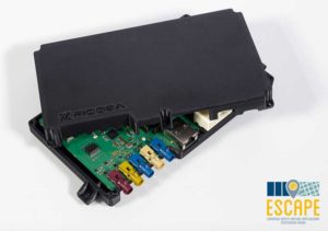
A European Union project has designed and prototyped the ESCAPE GNSS Engine (EGE), a positioning module intended to enable autonomous or semi-autonomous driving functions.
Automated vehicles are on the way, and the European GNSS Agency (GSA) sees satellite navigation as a core technology that will help to ensure their safe operation. At the recent Mobile World Congress in Barcelona, the GSA shared its space with the ESCAPE project, an EU-funded initiative that has developed a unique positioning module for autonomous or semi-autonomous driving.
Autonomous vehicles will feature both sensor-based and connection-based solutions for a variety of vehicle services. Ultimately, the GSA sees a “converged solution” as the best alternative, combining the strengths of both approaches. By integrating sensor data and connectivity-based information, operators can reduce the need for the most expensive sensors and at the same time save money on infrastructure.
The Fundamental Elements-funded ESCAPE project has designed and prototyped the ESCAPE GNSS Engine. It is a unique positioning module that combines precision GNSS and 4G connectivity, for the highly accurate and reliable positioning capabilities required to make automated driving a reality.
The ESCAPE GNSS Engine. (Photo: GSA)
“This is an onboard unit for autonomous vehicles,” said Jessica Garcia Soriano, R&D engineer of the Advanced Communications Business Unit at Ficosa. “It is equipped with a very good GNSS receiver made by STMicroelectronics. This was actually the first dual-frequency GNSS receiver made for the automotive market.”
Dual-frequency is of course a real differentiator for Galileo, as the world’s leading provider of dual-frequency GNSS signals. This means added precision and robustness and it helps enormously with multi-phase errors and other urban canyon issues in city-driving scenarios.
“We also have a very good positioning solution provided by GMV, another Spanish company. They are experts in these kinds of solutions. The outputs from this solution are very accurate. So we have GNSS of course, including Galileo, and apart from this you have a modem inside, a 4G modem that gets GNSS corrections from the internet, so this helps to provide better positioning. And apart from this you have inside the same module an inertial measurement unit [IMU]. This is a sensor, a device that senses acceleration and has a gyroscope, so this information also helps in providing good positioning.”
The ESCAPE unit also provides for the integration of other data from the vehicle. “That means vehicle odometry, for instance, you can have camera information, or information from maps that are stored in the vehicle, among others” Garcia said.
The market is ready
“One of our important goals is to provide a low-cost system,” Garcia said. “There are other very good positioning systems that are being developed that can be based on some very advanced technologies, such as LiDAR for instance, but this is very expensive. So our target is to develop and build a prototype of a system that could be installed in all vehicles, for the whole market. And so we are combining GNSS, 4G, IMU and all of these other data sources from the vehicle in an intelligent way, in an affordable way.”
Indeed, one of the things that make ESCAPE unique is the way it brings together high-end GNSS processing capabilities with an industrialisation process that targets high volumes and comparatively limited cost and size. It also encompasses hardware and software safety procedures required for certification for the automotive market.
Garcia explained, “At Ficosa, we are a top-tier global provider devoted to the research, development, manufacturing of vision, safety, connectivity and efficiency systems for the automotive sector. We provide solutions directly to vehicle manufacturers. Based on our expertise and thanks to the work we have done on this project, we understand very well that GNSS is a central focus for a lot of applications. From the moment we started working on this project, at Ficosa we realised that this is a new and very important market. Right now we are working on a positioning system for autonomous driving based on this unit. This is part of our roadmap at the moment. This is a positioning system that we are ready to offer to the customer.”
The unit is ready now, but we have yet to see autonomous cars in large numbers on the road. Is this a problem for the ESCAPE system? Garcia answered, “From the very first moment that you have an autonomous car in the street, you will need high-accuracy positioning, because these vehicles will need this positioning to maintain themselves safely on the road. But we don’t have to wait for autonomous cars. The vehicles on the road today can already benefit from this technology.”
Garcia pointed to Europe’s eCall system, where a call centre automatically receives location information from vehicles in distress, thanks to on-board GNSS. “You already have this emergency call technology in the vehicles,” Garcia said, “and it provides a location, so the better the location is, the easier it is to locate the people in an emergency situation. No, we don’t have to wait.”
Location and more
One thing everyone seems to agree on is that autonomous vehicles will soon be appearing on European road networks, and most driving-related decisions will be based, one way or another, on the location of the vehicle and of other vehicles and objects in its vicinity. So vehicle location and positioning will be a critical component for the effective transportation of people and goods by self-driving road vehicles. That positioning will be enabled mainly by GNSS technologies, including Europe’s Galileo, which is expected to offer significant benefits in terms of accuracy and authentication compared to the other satellite-based navigation systems.
GNSS-based location will have to be complemented by other technologies in order to get to the integrity level needed in all driving situations, but the GSA also believes the combination of dual-frequency GNSS and 4G/5G connectivity can do more than just navigation, enabling as well a diverse range of in-vehicle location-based services (LBS), much like what we see emerging in smartphones. The EU-funded ESCAPE project, with its innovative GNSS engine, represents an important step forward in the pursuit of accurate, reliable and affordable positioning and connectivity for the emerging autonomous and connected cars markets.
Following a waiver by the U.S. Federal Communications Commission (FCC) of its rules in November 2018, in which it allowed devices in the United States to access signals transmitted by the Galileo Global Navigation System, leading U.S. manufacturers are preparing to roll-out Galileo on U.S. territory.
At a meeting on Nov. 15 last year, the US FCC granted in part a request from the European Commission for a waiver of the FCC rules so that devices in the United States may access specific signals transmitted by Galileo.
This decision means that consumers and industry in the U.S. are now able to access certain satellite signals from the Galileo system, which can be used in combination with the U.S. Global Positioning System (GPS). The improved availability, reliability, and resiliency offered by incorporating Galileo capability into devices is something that U.S. chip manufacturers are eager to pass on to their customers.
“This is an important market development opportunity for manufacturers in the U.S. The FCC ruling means that industry can now benefit from the use of Galileo signals. The added accuracy and robustness offered by multi-constellation and multi-frequency capability will be a key differentiator on the market,” said Carlo des Dorides, Executive Director of the European GNSS Agency (GSA).
“We are glad to see FCC supporting Broadcom’s dual frequency GNSS vision, for which the GPS and Galileo combination is key,” said Vijay Nagarajan, VP Marketing Wireless Connectivity and Communication Division at Broadcom. “We enabled the world’s first dual frequency GNSS phone in 2018 with the simple goal of providing accurate location to the consumer even amidst the skyscrapers in a busy downtown. We are certain that consumers will benefit from this FCC ruling that will further drive the adoption of dual frequency GNSS.”
“As a leader in developing cellular technology — today, as the world launches 5G and dating back to Qualcomm’s legacy in 4G, 3G and 2G — including work to incorporate robust navigation solutions for smartphones, Qualcomm Technologies integrated Galileo across its chipset portfolio because we understand the importance and benefits of accurate, reliable, and rapid position location for consumers,” said Dean Brenner, senior vice president of Spectrum Strategy and Tech Policy, Qualcomm Incorporated. “We’re excited about the FCC allowing access to Galileo signals in the U.S. for commercial Location Based Services because it is a big step forward in improving the user experience, particularly in dense urban environments.”
Activating Galileo in the U.S.
Both Broadcom and Qualcomm Technologies, Inc. already have dual-frequency solutions that support Galileo E1/E5a signals: the world’s first dual frequency GNSS smartphone, the Xiaomi Mi-8, was fitted with a Broadcom BCM47755 chip and, in December, Qualcomm Technologies launched the newest generation in its 8 Mobile Platform Series, the dual-frequency Qualcomm Snapdragon 855 Mobile Platform.
“Approximately 100 smartphone models are already fitted with chipsets from these two manufacturers. Following the FCC ruling, we are expecting to see a significant increase in Galileo users coming from the U.S.,” said Justyna Redelkiewicz Musial, in charge of LBS and IoT market development at the GSA.
Better positioning and navigation
The FCC ruling permits access to two Galileo signals — the E1 signal that is transmitted in the 1559-1591 MHz portion of the 1559-1610 MHz Radio-navigation-Satellite Service (RNSS) frequency band and the E5 signal that is transmitted in the 1164-1219 MHz portion of the 1164-1215 MHz and 1215-1240 MHz RNSS bands.
Access to multi-constellation and multi-frequency capability means that users in the U.S. will be able to benefit from a better positioning and navigation experience particularly in urban environments where the unique shape of the E5/L5 signal makes it easier to distinguish real signals from the ones reflected by buildings, reducing the multipath effect. The simultaneous use of E5/L5 frequencies also mitigates other sources of error, such as ionospheric distortions, and makes the signal more robust against interference and jamming.
Responsibility for in-depth troubleshooting and problem resolution of the GSC Ground Infrastructure has been transferred from a European GNSS Agency (GSA)-held European GNSS Service Centre (GSC) infrastructure contract to Spaceopal and its core team member DLR GfR, responsible in the Galileo Service Operator (GSOp) industrial organization also for L2/L3 maintenance activity. This contract extends for 10 years.
The transfer occurred after Spaceopal successfully passed the Maintenance Handover Review (MHOR) for the Level 2 and 3 Maintenance of the GSC in Torrejón de Ardoz, outside Madrid, Spain.
“Taking over this responsibility will allow us to react much quicker to anomalies in a more flexible way, directly improving operations and the service that the European GNSS Agency (GSA) provides to the Galileo end users,” said Christian Hessmann, Engineering Manager at Spaceopal.
The GSC services can be accessed by Galileo users via the GSC web portal.
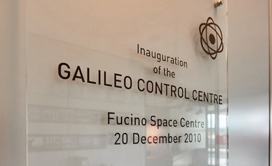
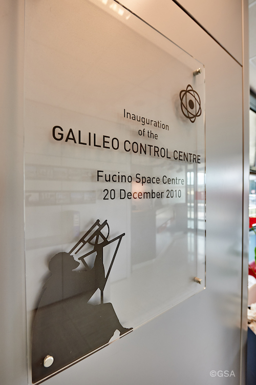
Spaceopal is a joint venture between DLR Gesellschaft für Raumfahrtanwendungen (GfR) mbH, a full subsidiary of the German Aerospace Center (Deutsches Zentrum für Luft- und Raumfahrt; DLR), and the Italian firm Telespazio S.p.A. Both parties contribute their respective Galileo Control Centers in Oberpfaffenhofen and Fucino.
Since July 2017, Spaceopal GmbH has operated the Galileo satellite fleet under the GSOp contract and will thus ensure the provision of the Galileo services to the worldwide community.
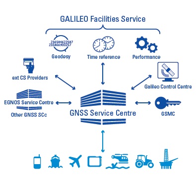
The GSC provides the single interface between the Galileo system and the users of the Galileo Open Service (OS), and the Galileo Commercial Service (CS) for the provision of specific services beyond the Galileo Signal-In-Space (SIS) transmitted by the operational satellites. The GSC acts as an active means to engage in “in”- and “out” bound activities and is conceived as a centre of expertise, knowledge sharing, custom performance assessment, information dissemination and support to the provision of value-added services enabled by the Galileo OS and CS core services.
The GSC is located in a fully secured environment in Madrid, Spain, within the National Institute of Aerospace Technologies (INTA) facilities at Torrejón de Ardoz, overseen by the Spanish Ministry of Defence.