Septentrio, a provider of high-precision GNSS positioning solutions, has partnered with Digi-Key Electronics, a global electronic components distributor. Digi-Key now offers mosaic-X5 globally for customers who need secure and reliable high-accuracy positioning in a compact and low-power form factor.
Image: Septentrio
Septentrio’s mosaic-X5 features complete multi-frequency multi-constellation technology and tracks every existing and future signal from all GNSS constellations.
Such signal diversity coupled with advanced anti-jamming technology allows mosaic-X5 to deliver centimeter-level positioning with maximum availability even in challenging industrial environments. This makes mosaic-X5 an ideal positioning solution for applications such as robotics, automation, telematics and many more.
“Our mosaic-X5 is an advanced GNSS receiver module without performance compromises. With its small form factor and low-power design, mosaic-X5 brings high-performance positioning to volume applications,” said Francois Freulon, head of product management for Septentrio. “Having Digi-Key as a distributor enables us to scale and reach out to find new markets and applications where secure high-accuracy positioning is required.”
“Digi-Key is excited about the new partnership with Septentrio,” said David Stein, vice president of global supplier management for Digi-Key. “Demand for high-accuracy GNSS receivers with secure and robust positioning is growing strongly, as they continue to be implemented into new applications and devices. Digi-Key offers customers an easy path to order, develop and deploy with the latest technologies available, including Septentrio’s robust and precise GNSS devices, which have the latest anti-jamming and anti-spoofing technology.”
Tilt compensation to increase productivity for land surveyors
Trimble has introduced the Trimble R12i GNSS receiver, the latest addition to its GNSS portfolio. The Trimble R12i incorporates inertial measurement unit (IMU)-based tilt compensation using Trimble TIP technology, which enables points to be measured or staked out while the survey rod is tilted.
The tilt function is designed to empower land surveyors to focus on the job at hand and complete work faster and more accurately.
The IMU-based tilt compensation capability of the Trimble R12i builds on Trimble’s unrivaled ProPoint GNSS positioning engine, which delivers more than 30 percent better performance in challenging environments compared to the Trimble R10-2 receiver across a variety of factors, including time to achieve survey precision levels, position accuracy and measurement reliability.
Designed with flexible signal management that enables the use of all available GNSS constellations and signals, the Trimble ProPoint GNSS engine provides new levels of reliability and productivity.
Photo: Trimble
In addition, the ProPoint engine is a key enabler of the new TIP technology. Surveyors can continue to use the R12i’s tilt compensation functionality even in challenging environments when other solutions struggle to maintain GNSS and inertial positioning.
The Trimble TIP technology allows users to accurately mark and measure points in areas previously inaccessible for GNSS rovers such as building corners, or in hazardous situations, for example the edge of an open excavation. The receiver operates calibration-free out of the box and is resistant to magnetic interference from sources such as cars or electrical utility boxes.
The R12i also features real-time automatic inertial navigation system (INS) integrity monitoring. This system allows users to detect and correct for IMU biases introduced by use over time, temperature or physical shocks helping ensure measurement quality and integrity for the life of the receiver.
“The R12i represents Trimble’s dedication to perfecting the user experience with the industry’s best GNSS engine and now robust tilt compensation,” said Ron Bisio, senior vice president of Trimble Geospatial. “Trimble has been the leader in GNSS technology for more than 30 years and the R12i demonstrates our continued commitment to providing surveyors with the world’s most advanced and trusted GNSS systems.”
The Trimble R12i GNSS System is available now through Trimble’s Geospatial distribution channel.
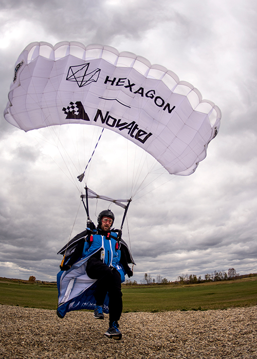
An applications engineer and his sky-jumping bud don wingsuits to test a NovAtel GNSS receiver integrated with an Epson IMU.
In September 2019, a specialized team assembled at an airstrip outside of Edmonton, Alberta, Canada. Their mission: Put the Hexagon | NovAtel PwrPak7D-E2 enclosed receiver through tricky test procedures that involved jumping out of an airplane at 10,000 feet.
Taking the NovAtel SPAN receiver to the skies was the brainchild of Andrew Levson, who is both a NovAtel engineer and a skydiving aficionado. He proposed using a wingsuit to test the receiver’s positioning accuracy.
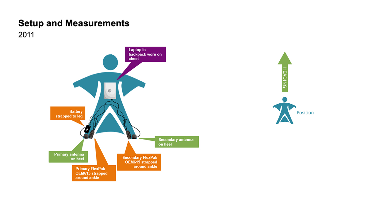
The first wingsuit dive took place in 2011, with NovAtel’s OEM615 receiver and ALIGN heading technology.
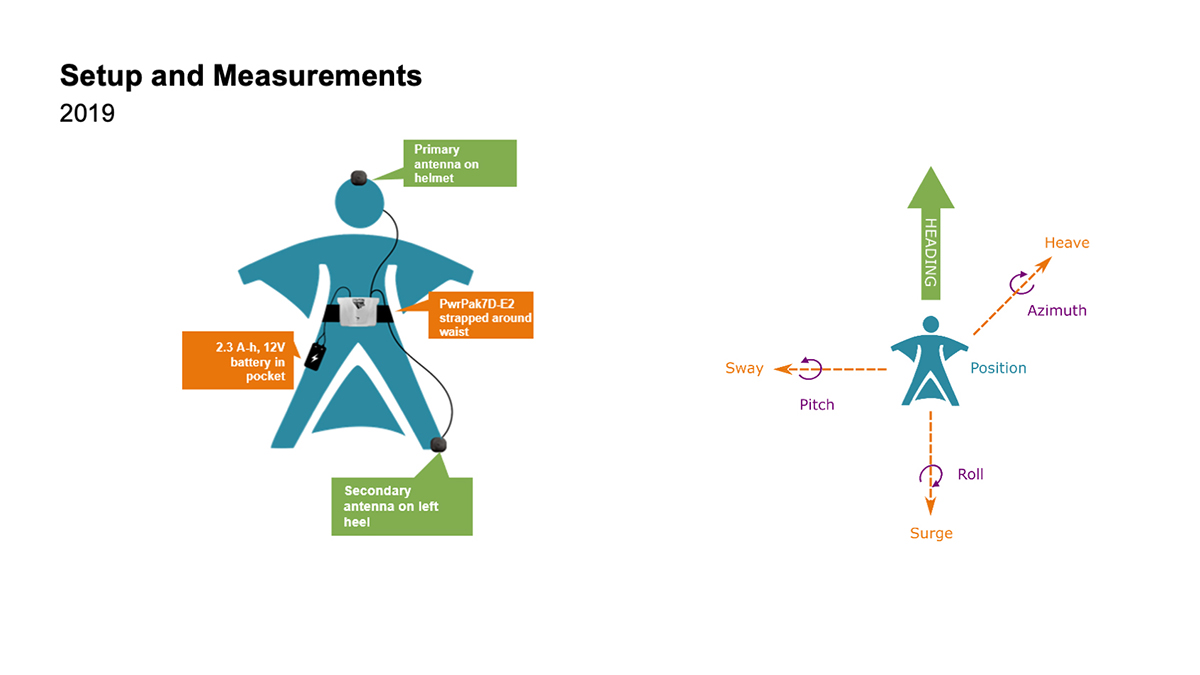
This time, the engineers aimed to test both NovAtel’s GNSS receiver featuring SPAN tightly coupled GNSS+INS functionality and its new companion, the Epson G370 inertial measurement unit (IMU). Both are packed in the PwrPak7D-E2 to provide uninterrupted positioning even in GNSS-denied environments.
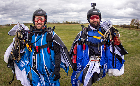
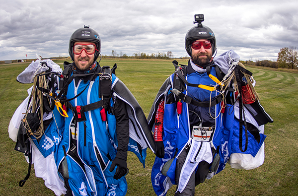
Wingsuit jumpers Andrew Levson (right) and Blair Egan suit up for the NovAtel tests. (Photo: NovAtel)
“We chose to revive the project, given that equipment has evolved with more comprehensive capabilities,” said Patrick Casiano, manager of Product Management and Applied Technology, NovAtel. “Between 2011 and 2019, we could significantly reduce the payload while increasing value in the data.” In 2011, NovAtel was only able to monitor Levson’s heading. In 2019, the team captured heading, azimuth, pitch and roll measurements.
“We wanted to prove that our equipment can work in a high-dynamic environment, which isn’t necessarily ideal conditions for collecting positioning data,” explained Kiera Fulton, associate product manager, Enclosures and Post-Processing Software, NovAtel. “By proving our products work in a less-than-ideal environment, we exemplify how robust our solutions are.”
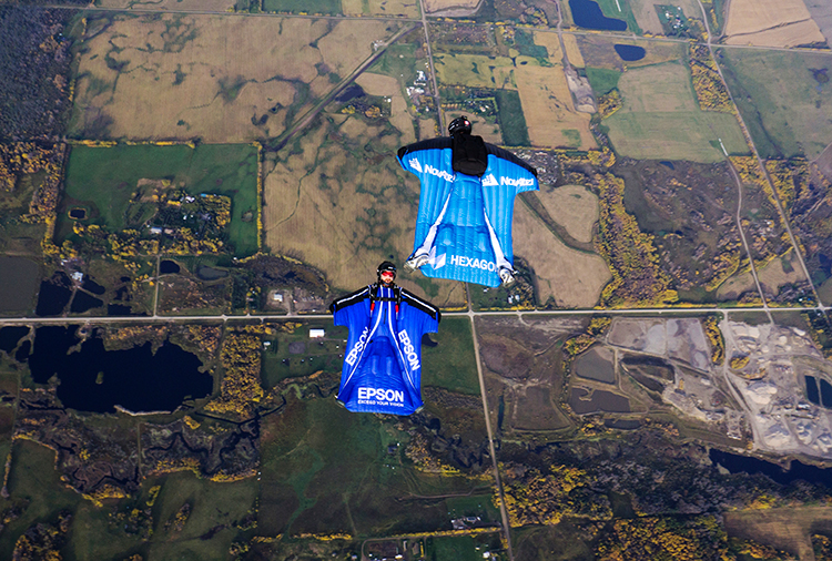
Photo: NovAtel
Test Preparation
For the 2019 test, the team chose to gather attitude data. The team also asked Levson to perform specific skydiving maneuvers to rigorously test the positioning solution. “Rather than performing just a simple flight to the ground, we wanted to challenge the solution to reveal more,” Casiano said.
The test was not easy to implement. A lot of behind-the-scenes planning and preparation went into the project. Plus, unforeseen factors made the test more challenging, Fulton said, such as logistics and weather.
“The skydivers require specific weather conditions in order to jump safely,” Fulton said. “Considering how quickly the weather can change here in Alberta, the time windows in which the skydivers could safely jump were few and far between. We pulled through regardless of these adversities.”
When the day of the jump came, the skydivers jumped five times — as many jumps as the weather would permit. “Theoretically, one jump is enough,” Casiano explained. “But as engineers, we always want to have more data to work with.”
2011 wingsuit jump setup. (Image: NovAtel)Wingsuit Jumps Compared: Because of the PwrPak7D-E2’s small size yet strong processing power, Levson required fewer devices in 2019 than in 2011, when he was equipped with two receivers, two antennas, a laptop and a battery. The amount of positioning data also increased. (Image: NovAtel)
High-Flying Maneuvers
The skydivers executed four maneuvers during their jumps.
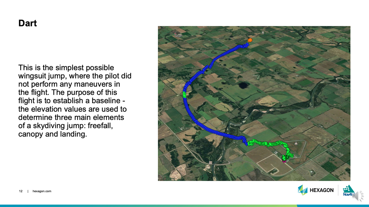
DART: This simple jump established a baseline for more complex maneuvers to follow. (Photo: NovAtel)
Dart. The skydivers first performed a straight jump, which the team called the Dart. The data from this jump provided a baseline for analyzing the positioning and attitude data.
“This was more important for the attitude analysis, as we have never collected inertial data in a skydiving jump before,” Fulton said.
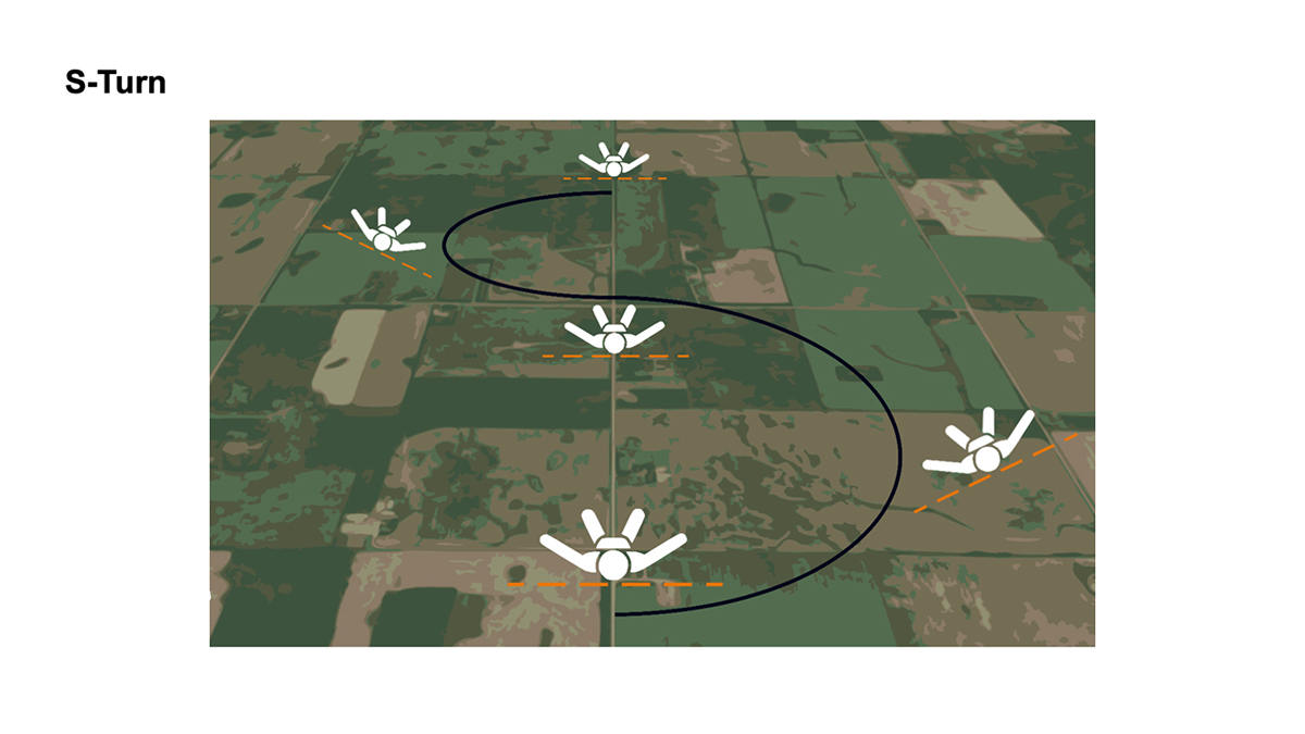
S-Turn: One of three completed maneuvers. (Image: NovAtel)
S-Turn. Next came the S-Turn. In this maneuver, Levson weaved from side-to-side to test how the equipment handles agile movements.
For the S-Turn, the engineers anticipated seeing the biggest changes in roll. “We were pleasantly surprised to see that the S-Turn is detectable in the azimuth data as well, indicating high correlation between roll and azimuth in a skydiver’s movements,” Fulton said.
The maneuver revealed that when Levson rolls, his body is using less surface area for wind resistance. As a result, he was falling to the ground faster, which then meant the dataset is shorter.
“This became another challenge during data processing, as the free-fall portion of the datasets were now becoming less than 3 minutes in duration,” Fulton said.
Data from the S-Turn also revealed the effect of crosswinds, which is detectable in the data.
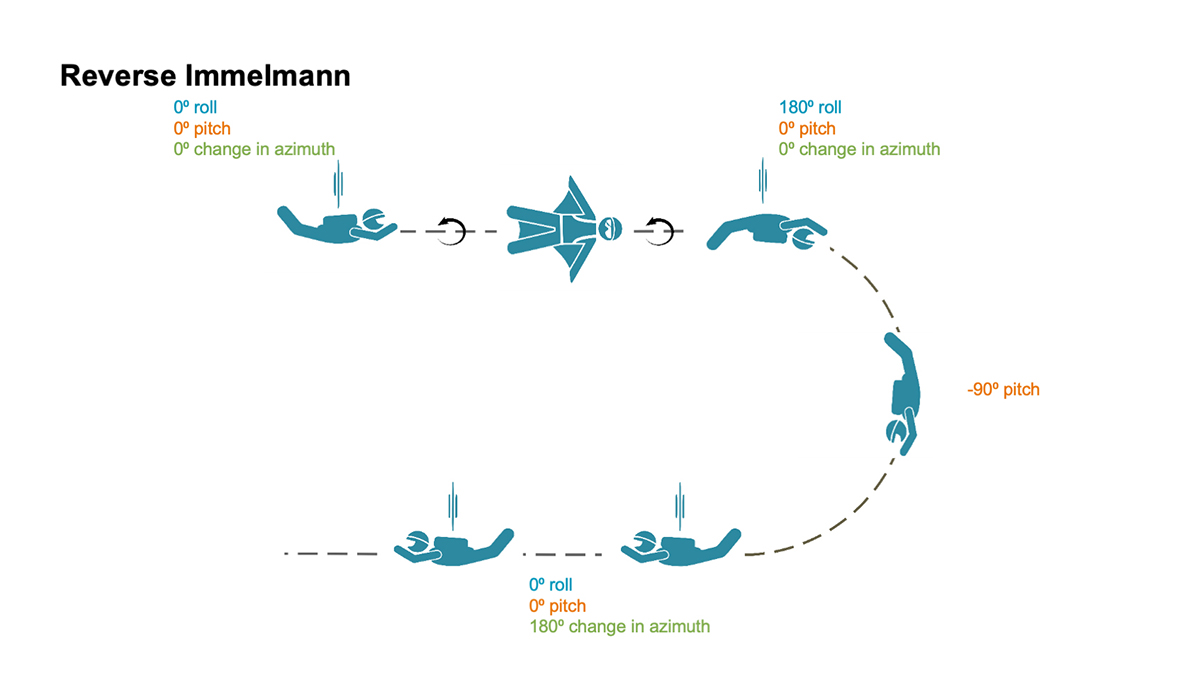
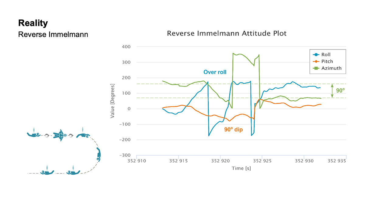
Reverse Immelmann: How the intricate maneuver works. (Image: NovAtel)
Reverse Immelmann. The third maneuver was the Reverse Immelmann. Levson flipped onto his back, began a downward turn until perpendicular to the ground, then leveled off, traveling in the opposite direction from where he began.
This complicated exercise provided data for all aspects of an attitude solution — roll, pitch and azimuth. By comparing the expected and real data, the team found several places where the maneuver wasn’t performed perfectly.
“There are many challenges once in the air that would have caused Levson to deviate from the trends in the data that we expected,” explained Fulton. “This is where we realized that our solution was working much more to evaluate the skydiver, rather than using the wingsuit to evaluate our product.”
Casiano agreed. “As a whole, the PwrPak7D-E2 was telling a story about Andrew’s flight,” he said.
The team also wanted to have the skydivers try a Cobra — a maneuver from aerobatics where an airplane momentarily lifts it nose and stalls — but time constraints prohibited it.
“If we had gotten this [a Cobra] recorded, it would have been detectable in the pitch and horizontal velocity data,” Fulton said. “Who knows what other findings we would have come across in this data!”
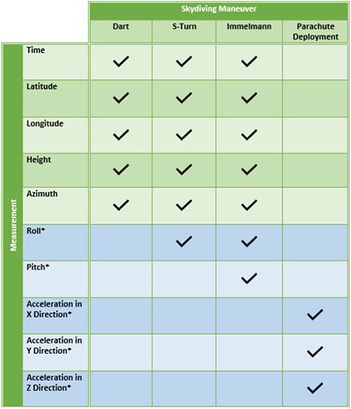
Measurement matrix: The asterisks (*) denote data values that can only be measured with an IMU. (Chart: NovAtel)
Applications
All these tests, of course, are designed to apply to real-world applications where the PwrPak7D-E2’s capabilities are used in dynamic environments.
For instance, an unmanned aerial vehicle (UAV) needs a feedback mechanism that tells the user whether it is moving or hovering. “In the wingsuit project, we proved that crosswind can be detected,” said Casiano. “This is an important finding for UAV applications, since a feedback loop from the PwrPak7 and the SPAN system can help rectify movement from external forces with counter propulsion to stay still. The PwrPak7D-E2 enclosures allow a data rate of up to 200 Hz, meaning you can capture motion with more detail.”
The PwrPak7D-E2 also works well for any black-box application where users want to record with the push of a button.
Inside the PwrPak7D-E2
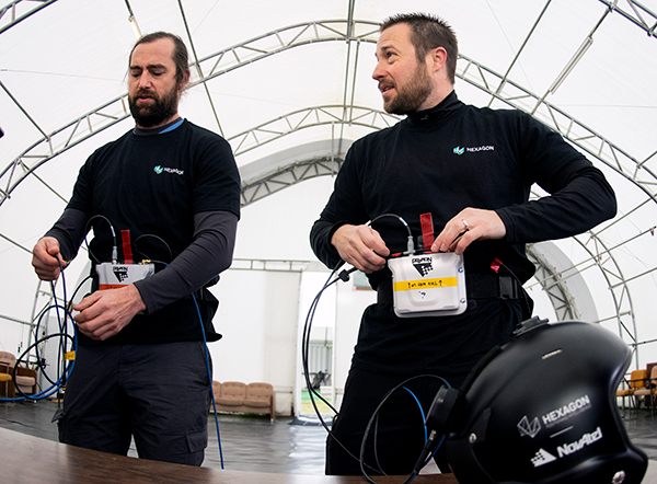
Photo: NovAtel
The PwrPak7D-E2 is an all-in-one product. Its components are designed to work together seamlessly to provide positioning data, housed in NovAtel’s OEM7 firmware.
GNSS receiver card used to capture positioning data
Dual-antenna capability to provide accurate heading
Epson IMU to record attitude and motion
On-board logging to eliminate the need for constant monitoring on a PC
Post-Processing
Preparation enabled the team to process the data on site. The on-board logging feature on the PwrPak7D-E2 eliminated the need for constant monitoring during data collection. The unit is pre-configured so that at the time of the jump, Levson only needed to push a button for the unit to start collecting data.
Once the pair of skydivers landed, the ground team offloaded the data for processing, similar to using a memory stick, and moved it to a laptop computer.
“We pulled raw measurement data from the receiver and processed those measurements into position and attitude information,” Fulton said.
It took about 30 minutes to determine whether the dataset was viable. Later processing back in the office generated the charts such as those below.
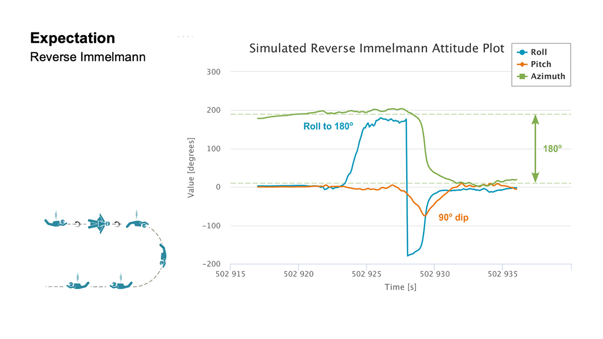
Expectation: For both the S-Turn and Reverse Immelman maneuvers, a simulated plot was generated at the office to better understand the inertial data produced from the actual wingsuit jumps. (Chart: NovAtel)Reality: This chart shows the actual data. (Chart: NovAatel)
Dynamic Environments
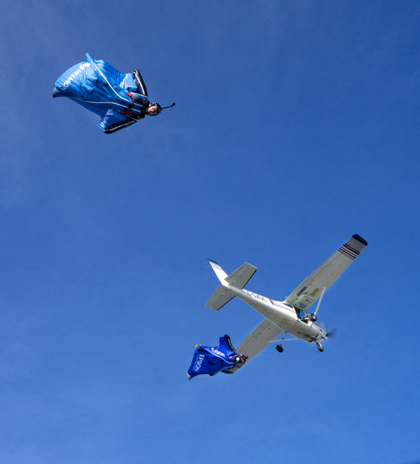
Photo: NovAtel
The PwrPak7 series can be used in many environments in the automotive, agriculture, marine, defense and UAV fields.
“We are constantly trying to find ways to apply this product to other applications and industries,” Fulton said. “With more testing, we keep finding that the PwrPak7 can be used to solve more challenges.
“We want to push the boundaries of our products. True innovation comes from challenging yourself and hovering outside your comfort zone,” Fulton said. “For this project, we are more than satisfied with the results we found. In order to further challenge ourselves and this product, we look forward to applying the PwrPak7 in more scenarios.”
“The PwrPak7 is a robust unit that sets us up for more exploration,” Casiano said. “We are always looking for more challenges to put this unit through to see how the PwrPak7 can further help solve our customer’s problems.
But will there be more skydiving for NovAtel in Levson’s future?
“We could always revisit the skydiving project in another nine years,” Casiano said. “But who knows how the technology will evolve by then?”
Post flight: Blair Egan (right) and Andrew Levson back on Earth. (Photo: NovAtel)
What it feels like to take the plunge
For those of us who have never jumped out of a plane, engineer and skydiver Andrew Levson provides insight.
“It’s not as scary as people think. Because the plane is moving fast, it’s mostly just windy and loud. You don’t get that roller coaster type feeling; in fact you don’t feel like you are even falling — freefall feels more like floating than falling. You definitely wouldn’t know you are flying at speeds over 100 mph.
“When you are climbing out of a plane, there is nothing else on your mind aside from the jump you are about to do. It is pure freedom, and there is often no stress, just a sense of peace and an intense focus on your plan for the jump. Once you get out of the aircraft, you get to fly your body in the way that you want to — most people only know of the position of falling with your body arched and belly toward the ground, but there are many different ways you can orient your body. Some of the lesser known ways to fly your body include your arms and legs spread out while flying a wingsuit (with your belly or back toward the earth) or flying with your head pointing straight at the ground.
“When you skydive, you get to explore the sky with your friends, which is an amazing and unique experience. During a skydive, it is common to experience an ultra-focus during the jump — time slows down a bit and you can see and feel things that are seemingly beyond your typical capability.Many people are amazed at how much skydivers are able to do in the short period of time that a single skydive lasts — about a minute for regular skydives and about two or three minutes when flying a wingsuit.”
With support for mmWave, Sub-6 GHz and LTE, Sierra Wireless modules will enable original equipment manufacturers to securely deploy 5G worldwide
Photo: Sierra Wireless
Sierra Wireless is now offering its EM919x 5G NR Sub-6 GHz and mmWave embedded modules, which include an integrated GNSS receiver.
Based on the industry-standard M.2 form factor, the 5G modules will enable original equipment manufacturers (OEMs) to deploy secure connectivity worldwide at the highest possible speeds with ultra-low latency for mobile computing, routers, gateways, industrial automation, and many new Industrial IoT applications.
With support for mmWave, sub-6 GHz and LTE, as defined by the 3GPP Release 15 standard, Sierra Wireless’ 5G modules will power next-generation devices that deliver high-bandwidth, low-latency applications.
Applications for the module include private networks, enterprise networking, edge processing, live streaming, video security, e-gaming, smart factories, robotics, drones, virtual reality and machine learning.
Allied Telesis, Dynabook, LiveU, NEC Personal Computers and Panasonic are among the OEMs designing their 5G platform to launch with Sierra Wireless’ EM919x modules.
Module versions available
The EM9190 5G NR Sub-6 GHz and mmWave embedded module delivers high 5G speeds. Along with the GNSS receiver, the module has automatic 4G and 3G fallback and FCC certification for CBRS networks to provides reliability, security and flexibility for Industrial IoT designs.
The EM9191 5G NR Sub-6 GHz module is also available in M.2 form factor, providing a simple upgrade path to mmWave, as well as the EM7690 LTE Cat-20 module to help facilitate the migration and differentiation between 4G LTE and 5G.
Sierra Wireless’ EM919x modules are built on the Qualcomm Snapdragon X55 5G Modem-RF System.
“5G is the most technically challenging evolution in the history of wireless, particularly because of the introduction of mmWave,” said Larry Zibrik, Vice President, 5G & Embedded Broadband, Sierra Wireless. “Sierra Wireless has delivered industry-leading embedded modules, beginning with the first generation of cellular data technologies, and we’re the only partner with the experience to help our customers navigate the complexities of 5G. Industry leaders trust Sierra Wireless to help them get to market on time with secure 5G connectivity, and to invest in the expertise required to enable future key features, such as dynamic spectrum sharing (DSS) and 5G NR standalone mode for even higher performance.”
“Sierra Wireless has been our trusted partner for integrating new mobile broadband technologies for many years. Now working with the EM919x for 5G, our next-generation 5G platform for mobile computing is processing on schedule, and our team can rely on Sierra Wireless’ leading technology and expert support to help manage the challenges that come with new technologies,” said Norimasa Nakamura, Executive Officer Product Development & Engineering, Dynabook Inc.
“Our latest generation of products has been designed to work with Sierra Wireless’ EM919x to unlock 5G potential and deliver superior video and audio capabilities with mission-critical transmission,” said Yaki Luzon, VP R&D, LiveU. “Sierra Wireless helps us ensure that LiveU is at the forefront of 5G technology for the broadcast and sports industries.”
“Sierra Wireless has been a trusted partner helping NEC bring new broadband technologies to market for many years,” said Yasuhisa Ito, Director of NEC R&D, NEC Personal Computers. “We’re pleased with how our work with Sierra Wireless’ EM9191/Sub-6 GHz is progressing on our next-generation 5G platform for mobile computing and look forward to providing unprecedented performance with our new 5G products.”
“5G is a completely new technology, and it will require a significant amount of effort from all parts of ecosystem to roll out,” said James Brehm, Founder & Chief Technology Evangelist, James Brehm & Associates. “Sierra Wireless’ long-standing position as an industry leader, and its relationships with carriers, infrastructure providers and chipset manufacturers will be an advantage for helping their OEM customers get to market on time and troubleshoot the teething issues we expect with new technologies. Working with Sierra Wireless significantly de-risks the process and speeds time to market for its partners. Sierra Wireless is the go-to partner for complex new technology launches.”
For more information on the modules, Sierra Wireless offers these resources:
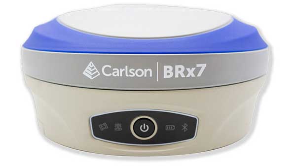
Carlson Software is now offering its next-generation multi-frequency, multi-GNSS BRx7 smart antenna.
The BRx7 is a full redesign of Carlson’s flagship GNSS receiver, delivering high-level specifications, performance and value for surveyors, contractors, engineers and GIS professionals.
Weighing 2.8 pounds with batteries, the BRx7 saves time and increases productivity by accurately compensating for tilt. It comes standard with dual, hot-swappable batteries for 11+ hours of uninterrupted efficiency. The BRx7 provides 800+ channels, 8gb of memory, and is designed with a rugged, compact IP67-rated housing.
Best-in-class RTK performance is provided by the Athena GNSS engine, supporting multi-frequency GPS, GLONASS, BeiDou, Galileo, QZSS, IRNSS and Atlas L-band capability. In addition, the BRx7 uses proprietary SureFix technology to provide a high-fidelity quality indicator of the RTK solution, allowing users an extremely high confidence in their current accuracy.
The BRx7 provides RTK baselines up to 50 km with fast acquisition times when used with Carlson Listen-Listen, as well as UHF, spread spectrum, cellular, Bluetooth and Wi-Fi wireless communication.
Well-suited to a variety of operating modes, the BRx7 can be deployed as a powerful base with additional access to BeiDou phase 3 satellites in a base-rover setup, or as a lightweight, powerful network rover.
“The BRx7 represents the next generation of GNSS technology,” said Butch Herter, Carlson’s director of hardware development. “Through this total redesign in partnership with our manufacturer, Hemisphere GNSS, we’ve brought the technology and functionality above the competition while retaining the ease-of-use, durability, and superior support that Carlson is known for.”
The smart antenna comes with a dual-band radio module that is capable of both 400 MHz and 900 MHz operation. This allows for the long range capability of the UHF 400 MHz signal plus the ability to switch to the 900 MHz frequency-hopping spread spectrum (FHSS) signal for better performance in noisy radio environments.
The BRx7 introduces a new INS-based sensor-fusion platform to support enhanced tilted pole measurements for land survey applications. This new design allows for easy calibration, is immune to magnetic interference, and is extremely reliable in virtually any environment.
“The BRx7 represents the advanced technology, durability, and ease-of-use that our customers have come to expect,” said Bruce Carlson, founder and president of Carlson Software. “By redesigning this system from the ground up, we are offering our customers both unparalleled performance and versatility, but also a value that’s unbeatable in the market today.”
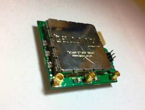
InfiniDome has released its GPSdome OEM board, which delivers GPS signal protection for UAV/UAS, fleet management and critical infrastructure.
According to the company, the GPSdome OEM board is designed for OEMs to fully integrate anti-jamming technology and deliver unmatched power and weight differentiation.
The GPSdome OEM board also is offered as a PCB solution. When integrated into a GNSS receiver, GPSdome OEM board not only detects the attack, but also shields the received signals from being overpowered by jammers, the company said.
When triggered, GPSdome OEM board sends an alert and notifies operators of the earliest possible detection of GPS/GNSS interferences. When infiniDome’s CommModule is integrated alongside GPSdome, the alert is sent to infiniCloud, infiniDome’s GPS Security Cloud, where users have access to real-time and statistical data on GPS attacks.
According to infiniDome, the GPSdome OEM board is ideal for several applications and can be integrated into the flight controller of drones, telematics unit for fleets and inside the time server for critical infrastructure.
“After learning from multiple customers that system size, weight and power limitations are getting more stringent, we addressed these market requirements with the smallest, lightest solution which will have minimal negative impact on system performance,” said Omer Sharar, CEO at infiniDome. “Our matchbook-sized GPSdome OEM board integrates into the flight controller of drones, the telematics unit for fleets, and inside the time server for critical infrastructure where it delivers signal protection for continuous operation of these mission-critical assets.”
For users seeking to retrofit their existing larger drones and realize quick time-to-market, infiniDome also offers the solution in an IP-67 housing. The GPSdome OEM board is compatible with any GNSS receiver on the market and compatible with any off-the-shelf GNSS antennas with minor integration efforts, infiniDome added.
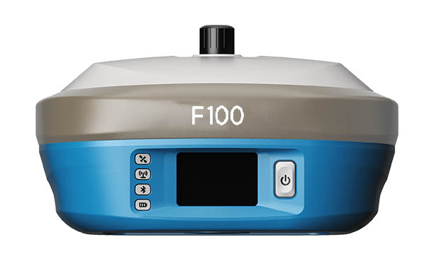
Geneq Inc.’s new F100 GNSS receiver, an upgrade to the F90, is designed to meet surveyors’ demands for high field performance, flexibility and cost-effectiveness.
The F100 tracks multiple constellations (GPS, GLONASS, Galileo, Beidou) and can maximize the acquisition and tracking process with all-in-view GNSS frequencies.
Another important feature from the F100 is the 1.45-inch color LCD display with a multi-touch capacitive screen. It has 32GB of internal memory. Its integrated second-generation web user interface control is compatible with all devices and all browsers.
Photo: Geneq
Providing maximum performance for accuracy and real-time measurements, F100 also supports real-time kinematic (RTK) correction services, including the RTX service that can get centimeter-level accuracy without a base station. The F100, with its advanced technology, ensures high performance even in difficult environments such as under heavy canopy.
The F100 has an excellent combination of GNSS, 4G, Bluetooth and Wi-Fi antenna. The innovative F100 has a built-in 5-watt radio that enables an effective baseline of 10 kilometers.
Its shorter charging time and a battery of 13600-mAh capacity enable long hours in the field. Even with its magnesium alloy casing, F100 weighs only 1.5 kg and measures 154 x 154 x 76 millimeters. Mobile field workers will find in this feature an ally to their surveying productivity.
With its integrated high-sensitive E-bubble and new tilt survey algorithm, the F100 becomes a calibration-free GNSS receiver. Immune to magnetic disturbance and free from limitation of tilt angles, the F100 can be used to measure unreachable points.
Septentrio’s mosaic-T is built specifically for resilient and precise time and frequency synchronization under challenging conditions. (Photo: Septentrio)
Septentrio has launched the mosaic-T GPS/GNSS receiver module, built specifically for resilient and precise time and frequency synchronization under challenging conditions.
According to the company, its multi-frequency, multi-constellation GNSS technology — together with AIM+ Advanced Interference Mitigation algorithms — allows mosaic-T to achieve maximal availability even in the presence of GNSS jamming or spoofing. This compact surface-mount module is designed for automated assembly and high-volume production.
“We are excited to expand our mosaic GNSS module family with mosaic-T, which will provide critical infrastructure and mission-critical PNT applications with accurate, reliable and resilient timing solutions,” said Francois Freulon, head of product management at Septentrio.
Septentrio mosaic-T delivers timing with nanosecond-level accuracy and has additional inputs for an external high-accuracy clock, the company added.
Septentrio, headquartered in Leuven, Belgium, designs and manufactures multi-frequency multi-constellation GPS/GNSS positioning technology for demanding applications.
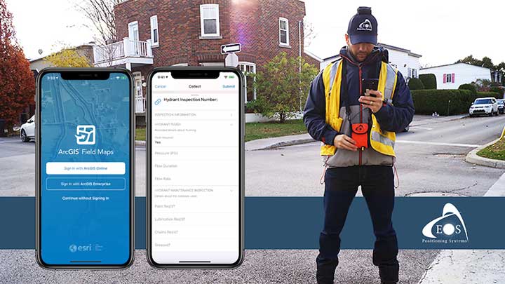
A new Esri mobile app, ArcGIS Field Maps, will be released in its first beta in July, with the final version expected to be released in September.
According to Esri, Field Maps will combine the following capabilities into a single app:
Simple map viewing and markup
High-accuracy field data collection and inspection
Battery-optimized location tracking
Work planning and task management
Turn-by-turn navigation
Field Maps also will include a new web app, integrated with ArcGIS, that can be used to configure and deploy maps optimized for your mobile workforce needs, create and assign tasks to mobile workers, and create and share views of worker locations.
Arrow support included
The inaugural beta includes support for Arrow GNSS receivers’ high-accuracy locations, elevations and metadata, according to Eos Positioning.
ArcGIS Field Maps will provide the combined functionality of five Esri mobile apps: ArcGIS Collector, ArcGIS Explorer, ArcGIS Tracker, ArcGIS Workforce and ArcGIS Navigator.
In the first beta version, users will be able to perform markups, work with read-only maps, and work with MMPKs, including high-accuracy GPS locations and metadata from Arrow GNSS receivers.
Photo: Eos Positioning
Customers who have been wanting to take advantage of high-accuracy GNSS data in apps such as Explorer and Tracker will now be able to with the beta release. Customers who would like to have field crews able to access read-only maps with high-accuracy, for instance (such as during utility locates), this is now a possibility. In addition, crews can take advantage of high-accuracy GPS tracks while tracking.
ArcGIS Field Maps will also support the two formerly Collector-exclusive Eos solutions Eos Locate and Eos Laser Mapping.
Eos Locate. This high-accuracy underground mapping solution will be available in ArcGIS Field Maps right away in the first beta release. A single fieldworker will be able to perform real-time, high-accuracy mapping of underground assets using the same workflow he or she had previously used with Collector and Arrow GNSS.
Eos Laser Mapping. Similarly, laser offsets with Arrow GNSS receivers and LTI laser rangefinders will be available in the first beta of ArcGIS Field Maps. Learn more about laser offsets, including the three workflows for using them, here:
“We are incredibly excited for the new opportunities ArcGIS Field Maps brings to expand our partnership with Esri,” Eos CTO Jean-Yves Lauture said. “Now our joint customers will be able to use the Arrow GNSS receivers with Field Maps to access high-accuracy location when simply viewing and marking up maps and when logging location tracks.”
Eos Positioning told its customers, “We encourage all Eos customers currently using Collector, Tracker and/or Explorer to join the beta. Meanwhile, Collector, Tracker and Explorer are planned to continue working as usual, according to the roadmap Esri has outlined.”
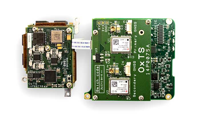
The xOEM v3 includes the architecture from the company’s IP65-encased xNAV v3 as well as a full range of software interfaces, providing integrators maximum configuration flexibility, real-time monitoring, post-processing and analysis. Software interfaces can be customized using the OxTS NAVsuite. Plugins can be created using the company’s NAVsdk, allowing the xOEM v3’s software to be easily packaged and included as part of a product.
The board set is compact at 150 grams, which enables manufacturers to seamlessly integrate and build a high-performance INS into their products, such as commercial mapping applications on land and in the air. Its light weight means more payload capacity for other critical components. An add-on lidar georeferencing software package is also available with a sophisticated boresight calibration tool.
The high-grade MEMS inertial sensors and real-time kinematic (RTK) capable GNSS receiver within the xOEM v3 board set deliver high performance capabilities. The board set provides 0.1° heading accuracy, 0.05° pitch/roll accuracy and 2 cm global position accuracy.
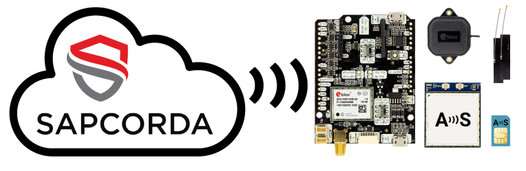
The basic ArduSimple RTK kit includes Sapcorda SAPA. (Image: ArduSimple)
ArduSimple has integrated Sapcorda’s SAPA Premium Service into its new simpleRTK2B+SSR GNSS receiver. The user-friendly integration based on SSR technology allows plug-and-play real-time kinematic (RTK) without the need for a base station. Users can connect the receiver to their PC or tablet to achieve centimeter-level accuracy.
Based in Berlin, ArduSimple develops user-friendly, affordable RTK receivers and tools for evaluation of multi-band GNSS technology.
The simpleSSR basic starter kit includes a multi-band RTK receiver, SSR receiver, one year unlimited data package and one year SAPA Premium license. Accurate position is available via USB, UART and I2C, as well as via Bluetooth, Wi-Fi or RS232 with the corresponding accessory.
“ArduSimple’s vision is to make RTK technology affordable and accessible to everyone. Removing the hassle of the base station is a key step towards it,” said Josep Olivart, Senior Consultant at ArduSimple. “The decision to select Sapcorda was clear: best in class service performance at affordable mass market price, supported by a highly skilled and committed team.”
Sapcorda provides GNSS augmentation services for the internet of things (IoT), automotive, and industrial applications across the United States and Europe including up to 20 kilometers off coastlines, delivered with low-bandwidth data over internet and satellite, and providing uniform, high-integrity instantaneous sub-decimeter positioning on a continental scale with enterprise-level service availability.
“Sapcorda aims to establish GNSS precise positioning in mass-market applications and ArduSimple is an ideal partner for the integration of our services into a high precision GNSS hardware,” said Botho Graf zu Eulenburg, managing director at Sapcorda. “The combination of our advanced services with ArduSimple’s new platform provides an easy to use and affordable high precision solution to everyone.”
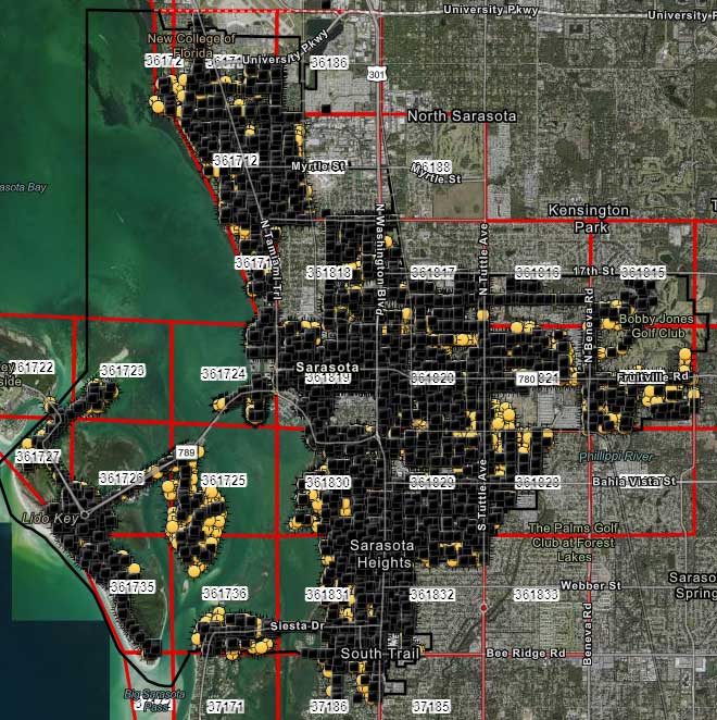
City officials in Sarasota, Florida, kept their staff actively working during COVID-19 social distancing mandates by training and tasking them with mapping utility data in the field.
The city’s plan to rebuild its GIS database had an estimated five-year timeline. GIS Coordinator William Rockwell suggested to city manager Tom Barwin that those unable to work from home be trained to collect the data. Rockwell worked with Sarasota IT Director Herminio Rodriguez to calculate the cost of acquiring enough GNSS receivers for the idle staff to use, and discovered a substantial cost savings.
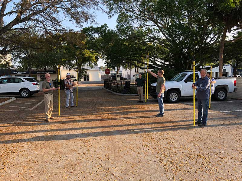
Hands-on training took place in the Sarasota City Hall parking lot, with trainees practicing social distancing. (Photo: Eos Positioning)
“By implementing this project, we not only keep city staff productive, but we’ll also be collecting data that would otherwise cost hundreds of thousands of dollars if we outsourced the work,” Rockwell said.
Training from a Distance. Rockwell obtained affordable Arrow 100 GNSS receivers from an Eos Positioning distributor and hosted small-group training sessions in the city hall parking lot. Employees from a multitude of different departments were trained, such as a parking enforcement officer and a transportation planner.
All employees were carefully kept six feet apart. From a maintained distance, Rockwell explained the basic concept of data collection using high-accuracy Arrow 100 receivers with ArcGIS Collector.
The new team mapped 93% of street lights and road signs in one month. (Photo: Eos Positioning)
The employees took turns collecting sample data so Rockwell could address any initial concerns. He also gave each of them a printed map series, created in ArcGIS Pro, that showed the city divided into 28 grids. This allowed the team members to easily mark off where they collected data each day.
At the end of each day, the workers synced their data, collected by the Arrow 100s, to ArcGIS Online, which allowed Rockwell to monitor progress.
To date, 14 field workers have collected 93% of the city’s 6,000 street lights and 16,000 road signs. Although the 30-day project pilot has finished, the city plans to collect the remaining lights and signs, as well as the city’s 35,000 trees, later this year. High-accuracy GIS data collection has received encouraging feedback from management.
“I’m thrilled the city is supporting this initiative,” Rodriguez said. “To be able to take employees doing very, very different jobs and put them in the field — this wouldn’t have been possible in a normal environment. We are excited that everyone is chipping in.”