Tag: GNSS receiver

  • Septentrio begins production of mosaic-X5 for high-volume applications

    Septentrio begins production of mosaic-X5 for high-volume applications

    Image: Septentrio
    Image: Septentrio

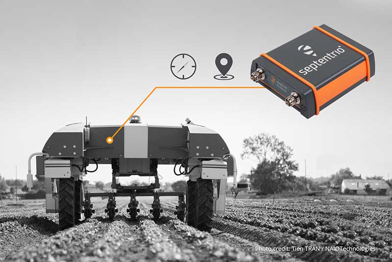
    Septentrio is starting high-volume production of mosaic-X5, its next-generation multi-constellation and multi-band receiver module.

    Featuring the company’s latest GNSS technology, mosaic-X5 brings centimeter-level positioning to technologies such as robotics, automation, smart wearables and telematics among others. Its small form factor and low-power design makes high-performance positioning accessible to volume applications, the company said.

    “For smooth, uninterrupted operation in the field mosaic-X5 is the logical choice for an industrial-grade GNSS positioning module,” said Francois Freulon, head of Product Management at Septentrio. “In an industrial setting the cost of equipment downtime can quickly get out of hand. We designed mosaic to be robust in difficult environments, ensuring continuous operation as well as quick set-up times for our customers.”

    Septentrio’s mosaic-X5 was conceived to be the first GNSS receiver module on the market without performance compromises. Featuring complete multi-frequency multi-constellation technology mosaic receives every existing and future signal from all GNSS constellations including the American GPS, European Galileo, Russian GLONASS, Chinese BeiDou, Japanese QZSS, Indian NavIC and L-Band satellites. Such signal diversity allows maximum positioning availability even in difficult environments such as near tall structures or under foliage.

    The compact GNSS module features Septentrio’s proprietary Advanced Interference Mitigation (AIM+) technology, which shields the receiver from jamming and malicious spoofing. This allows machinery and robotics equipped with GNSS to keep on working, instead of being grounded by RF interference. mosaic-X5 also includes the unique RAIM+ integrity engine essential for safety-critical applications such as autonomous systems.

    For those who want to try out the mosaic-X5, evaluation kits can now be ordered directly at shop.septentrio.com.

    Volume order quotes can be requested at shop.septentrio.com/quote.

    For more information about mosaic or other Septentrio precise positioning and timing solutions, contact [email protected]/

  • How machine control and precision agriculture are changing job sites

    How machine control and precision agriculture are changing job sites

    Photo: Trojak Communications
    Photo: Trojak Communications

    GNSS, coupled with inertial systems and software, is enabling greater accuracy in construction and agriculture. Other markets using machine control include unmanned vehicles, mining, surveying, mapping and defense.

    At construction sites, GNSS receivers can be found in heavy equipment such as bulldozers, excavators, graders and pavers. On farms and in orchards, GNSS increases productivity of machines ranging from tractors to UAVs.

    A new MarketsandMarkets report predicts the machine control system market will grow to $6.6 billion by 2024, a compound annual growth rate (CAGR) of 8.16%.

    For precision agriculture, the outlook is even brighter. Grand View Research anticipates the market will reach $12.9 billion by 2027, a CAGR of 13% over the period.

    Machine control speeds projects and increases efficiency under tight timelines. Using GNSS to guide the heavy lifting also alleviates safety concerns related to workers and construction machinery, and provides situational awareness to field operators.

    In this month’s feature, we share case studies from companies that specialize in these markets, provide product details, and review the status of real-time kinematic (RTK) GNSS in agriculture.

    Check out some use cases for how GNSS, inertial systems and software are enabling greater accuracy in construction and agriculture.

  • Septentrio receiver tackles machine control in challenging environments

    Septentrio receiver tackles machine control in challenging environments

    Image: Septentrio
    Image: Septentrio

    Septentrio has added to its integrated GPS/GNSS receiver portfolio with the AsteRx SB ProDirect, which delivers reliable high-accuracy positioning for machine navigation and control in challenging environments.

    The AsteRx SB ProDirect dual-antenna receiver is designed as an “install-and-forget” device to provide continuous positioning for demanding industrial applications, Septentrio said. It gives machines and robotics access to heading and pitch or heading and roll information immediately on power-up. This allows for trajectory path optimization and fully informed navigation from mission start.

    The AsteRx SB ProDirect is designed to provide the GNSS positioning and position-independent heading needed for robotics, machine control and similar applications. It uses either a single or dual antennas and is designed for quick integration into any machine monitoring or control system.

    Contained in a single, waterproof ruggedized box, the robust receiver uses Septentrio’s LOCK+ technology, optimizing positioning and heading performance under intense mechanical vibrations, shakes or shocks.

    Septentrio also offers housed GNSS/INS receivers with inertial integration for a full attitude solution, including heading, pitch and roll, on top of high-accuracy positioning. Integration of the AsteRx SBi’s inertial sensor allows continuous positioning and attitude even during short GNSS outages, which can happen near high structures or under foliage.

  • David Plus GNSS receiver applied in intelligent forklift

    David Plus GNSS receiver applied in intelligent forklift

    Image: Tersus GNSS
    Image: Tersus GNSS

    With the development of intelligent shipping ports, many port-related tools — gantry cranes, loaders and forklifts — can be made autonomous and controlled automatically. These applications use GNSS to obtain positioning and orientation data for machine operators.

    In traditional container-intensive terminals, forklift drivers spend a lot of time locating the designated goods; operating the forklift itself requires highly experienced drivers. Tersus GNSS offers a positioning and orientation solution that can greatly reduce the need for experienced drivers, improve the port’s operational efficiency, reduce error rates and improve accuracy.

    Installed on an autonomous forklift, a David Plus receiver and anti-interference GNSS dual antenna calculates positioning solutions, enabling operators to locate exactly where the target goods are and guide the forklift to them via the quickest, most convenient routes.

    The David Plus’s compact design can be easily installed on even small forklifts without affecting normal operation. The David Plus obtains high-precision positioning and orientation values by connecting via wireless to an Ntrip network, and then forwards corrections to the port-dispatching system as raw data.

    The David Plus supports GPS L1/L2, GLONASS L1/L2 and BeiDou B1/B2 from the primary antenna, and GPS L1/GLONASS L1 or GPS L1/BeiDou B1 from the secondary antenna. Its 384 channels can capture numerous satellite signals within a short time.

    Image: Tersus GNSS
    Image: Tersus GNSS

    With an IP67-rated enclosure, the David Plus GNSS receiver is built for outdoor environments such as shipping ports. A palm-sized unit, it can be easily integrated with various application systems. As a backup data-saving measure, 4 gigabytes of built-in memory record data for post-processing.

    A manned forklift can benefit from the positioning data. When the forklift reaches the designated position in the stack, the heading antenna will calculate the correct lift height of the forklift arm. This provides a suitable height for handling the cargo, and prevents accidents such as the cargo falling.

    For a fully autonomous forklift, the system will automatically analyze the orientation data and lift the forklift arm to the corresponding height of the cargo. It will then retrieve and lower the cargo to a safe height, and automatically drive it to the new storage point. During this process, additional infrared obstacle avoidance sensors can accurately identify the distance between the forklift and the cargo, avoiding inadvertent collisions.

    The positioning and orientation data obtained by the David Plus can be shared with third-party software and hardware. For instance, port terminal systems can configure containers to capture distribution information and instructions. By importing the positioning information of the forklift equipped with David Plus into the system in real time, it is possible to calculate the optimal driving trajectory to the final cargo delivery point.

    The Tersus David Plus positioning and orientation solution can combine its own high-precision positioning and orientation data with other automation system hardware and software to form a complete forklift unmanned/manned automated driving and handling solution.

  • NVS Technologies debuts NV216C-RTK-A GNSS receiver at Intergeo 2019

    NVS Technologies discusses its NV216C-RTK-A multi-frequency GNSS receiver at Intergeo 2019, which took place Sept. 17-19 in Stuttgart, Germany.

  • Carlson introduces Vsx7 GNSS receiver for machine control

    Carlson introduces Vsx7 GNSS receiver for machine control

    Photo: Carlson
    Photo: Carlson

    Carlson Machine Control has introduced the Vsx7 multi-frequency position and heading receiver. The Vsx7 is a multi-GNSS receiver designed specifically for machine control and can be installed on excavators, drills, pile drivers and more.

    Paired with the Carlson A45 antennas, the Vsx7 features high-precision positioning in Athena RTK, Atlas L-band and SBAS and heading accuracy of up to .01 degrees. The whole Vsx7 system is designed to operate in harsh conditions from -40 degrees Fahrenheit to 158 degrees Fahrenheit. It can be mounted either by bolts or with magnets depending on the application and external environment.

    The Vsx7 is primarily used in the mining and construction industries but can be adopted into similar industries with its companion software, Carlson Grade. Field data can be collected and viewed in real-time both at the machine with either, the MC8 or MC10 control box as well as in the office with Carlson Command.

    “Our customers are able to operate day after day with complete confidence in their machine guidance,” says Tim Jones, director of Machine Control. “The Vsx7 is a perfect form factor for our customers and to Carlson Grade and Carlson Command as a ruggedized GNSS receiver.”

    Carlson Grade is a machine guidance software solution that can be adapted to any heavy machine for grading, excavating, mining, shoveling, drilling, pile driving and landfill operation. Carlson Grade provides real-time field reporting and allows operators to view where they are in the project and at all times.

    Carlson Command is a site management software solution that provides multiple viewing options of multiple and single machines in real-time. Command allows machine positions to be viewed as well as cut/fill and elevation. Managers can also remote into machines and transmit messages directly to an operator.

  • UAV Navigation compatible with new Trimble UAS1 GNSS receiver

    UAV Navigation compatible with new Trimble UAS1 GNSS receiver

    UAV Navigation’s flight control solutions for remotely piloted air systems/unmanned aerial vehicles (RPAS/UAVs) are compatible with the Trimble UAS1 high-precision GNSS receiver. The core benefits of Trimble’s GNSS solution include centimeter-level precision and easy integration.

    Image: UAV Navigation and Trimble
    Image: UAV Navigation and Trimble

    The light, small Trimble UAS1 receiver is less vulnerable to vibrations or temperature fluctuations, making it suitable for UAVs and RPAS. In addition, the receiver can provide real-time kinematic (RTK) positioning using a base station, enabling users to achieve higher precision for their projects.

    Most UAV missions demand precision in its subsystems. The Trimble UAS1 receiver meets these requirements and includes a 336-channel high-precision GNSS engine. It tracks L1/L2 frequencies from the GPS, GLONASS, Galileo and BeiDou constellations.

    The Trimble UAS1 supports OmniSTAR and Trimble CenterPoint RTX GNSS corrections, which enable precise and robust positioning without the use of a base station via a subscription service. The receiver also offers an industry-standard camera hot-shoe interface and a wide DC voltage range to work in a broad range of UAVs.

    While Trimble is highly specialized in providing advanced GNSS solutions, UAV Navigation’s focus is on innovations in flight control systems. With this combined technology, current UAV/RPAS systems can now operate in more demanding environments and deliver higher precision through better navigation, UAV Navigation stated in a press release.

  • Septentrio launches online shop for GNSS receivers

    Septentrio launches online shop for GNSS receivers

    Image: Septentrio
    Image: Septentrio

    Septentrio’s new web shop offers direct access to mosaic multi-frequency GNSS receiver module. Customers can purchase the mosaic development kit quickly and easily to evaluate this unique module.

    Septentrio has opened an online store shop.septentrio.com, selling high-performance GPS/GNSS module receivers. The web shop is accessible via the Septentrio website, offering customers multi-constellation multi-frequency GNSS technology, which provides reliable centimeter level positions suitable for demanding applications.

    The first product available for sale online is mosaic, Septentrio’s most compact GNSS receiver module. This light-weight, low-power receiver brings robust high-accuracy positioning to the mass market. With its security-centered anti-jamming and anti-spoofing technology, mosaic provides positioning to numerous demanding applications such as automotive ADAS, logistics automation, and robotics.

    “We see a growing demand for reliable high-accuracy positioning across various industries. As GNSS receivers move towards becoming a commodity, we are providing our customers with easier and faster access to GNSS technology,” said Francois Freulon, senior product manager, Septentrio. “We are happy to offer the mosaic development kit as the first product in the shop, which makes it easy for people to purchase and evaluate the mosaic module and discover its capabilities for delivering robust, highly-accurate positions. “

    True multi-frequency multi-constellation technology of mosaic ensures access to every possible signal from all available GNSS constellations including the U.S. GPS, European Galileo, Russian GLONASS, Chinese BeiDou and Japanese QZSS satellites. Septentrio’s advanced field-proven algorithms exploit this signal diversity to deliver maximum positioning availability even in the most difficult environments such as under foliage or in urban areas.

    GNSS signals can become jammed by nearby electronics or illegal jammers that emit radio signals interfering with GNSS. Mosaic uses jamming-resistant signal processing making it robust against interference. Its design focuses on continuous, reliable high-accuracy positioning making mosaic suitable for demanding applications such as ADAS, UAVs and industrial automation.

  • Fraunhofer and PRoPART successfully test autonomous merging

    Fraunhofer and PRoPART successfully test autonomous merging

    On a test track in Sweden, a truck successfully merged between two cars driving alongside it in a fully automated maneuver. The live demonstration took place at the AstaZero test site near Borås, Sweden, on Nov. 21, 2019, showing automotive industry experts how well the automated merging solution performed.

    The Fraunhofer Institute for Integrated Circuits IIS and project partners RISE, Scania, Waysure, Ceit-IK4, Baselabs and Commsignia are taking part in an EU-funded project PRoPART, which stands for Precise and Robust Positioning for Automated Road Transports.

    Vehicles on the road already perform certain steps on behalf of the driver, such as parking. Together with its project partners, the Fraunhofer IIS has developed a precise and robust position determination system for use in autonomous trucks as part of PRoPART.

    Autonomous driving is about interactions among vehicle systems, connecting vehicles and equipping them with precise and robust navigation solutions. The challenge is to ensure that different automated driving systems deliver precise and reliable positioning information.

    Using GOOSE technology

    With its GOOSE GNSS receivers, Fraunhofer IIS provides highly accurate and reliable positioning to the PRoPART project. The GOOSE can bridge signal interruptions for short periods of time, potentially obviating the need for the driver to intervene at all.

    In conjunction with GNSS, developers are using a combination of sensors such as radar and cameras in the vehicle. Supplemented by reference stations along the route, the combination of GNSS and sensor data enables highly available position solutions up to the decimeter range.

    “This is a key step on the road to autonomous driving,” explained group manager for precise GNSS receivers Matthias Overbeck, Fraunhofer IIS. “It’s about ensuring the merging maneuver is precise and avoiding accidents — something we can achieve only with highly accurate and reliable positioning technology.”

    GOOSE platform. (Photo: Fraunhofer IIS)
    GOOSE platform. (Photo: Fraunhofer IIS)

    Spoofing protection

    These days, a variety of electronic systems for providing satellite navigation signals are available and are often used to generate fake positions for gaming apps on smartphones. Such systems could disrupt satellite receivers while remaining undetected.

    GOOSE makes use of the Galileo Open Service Navigation Message Authentication (OS-NMA), which is not officially available until 2020. OS-NMA transmits encrypted keys on the Galileo satellite signals that make it extremely difficult to fake a position, thus ensuring that reliable positioning information can be provided to vehicles in the future.

  • Seen & Heard: Karma drone down, GLONASS guides missiles

    Seen & Heard: Karma drone down, GLONASS guides missiles

    “Seen & Heard” is a monthly feature of GPS World magazine, traveling the world to capture interesting and unusual news stories involving the GNSS/PNT industry.


    Photo: Karma drone/GoPro
    Photo: Karma drone/GoPro

    Bad karma

    The GoPro Karma drone has been grounded since the new year began, reports The Verge. Multiple owners say their Karma controllers are flashing errors about not receiving a GPS signal, and that they can’t calibrate the compass. They’re not able to fly the drones even after disabling GPS. A GoPro spokesperson told The Verge that it is “actively troubleshooting” the issue.


    Going wild at the casino

    A Waze ad in January misdirected drivers headed to Atlantic City’s Borgata Hotel Casino & Spa into New Jersey’s Pine Barrens. Jackson Township police helped numerous motorists stuck on unpaved roads about 45 miles from the casino, which is just off the Atlantic City Expressway. The address on the ad was correct, but the location pinned with the ad is actually in the Colliers Mills wildlife area.


    Photo: Rock penguins/Charles Bergman/Shutterstock.com
    Photo: Rock penguins/Charles Bergman/Shutterstock.com

    Feed the birds, not the mice

    Irish structural engineer John Houston used a Trimble R10 GNSS receiver and Centerpoint RTX to help mitigate a serious threat to Gough Island’s birds. The Royal Society for the Protection of Birds seeks to eradicate invasive mice left from 19th-century ships. The survey will help locate temporary infrastructure for workers to distribute poisoned bait to kill the voracious rodents, which feed on two million defenseless eggs and chicks each year. Though 1,000 kilometers from the nearest reference station, Houston achieved centimeter accuracy on all survey points. See the monster mice here.


    Photo: U.S. Marines at Al Asad Air Base in 2018. (Cpl. Jered T. Stone/Marine Corps)
    Photo: U.S. Marines at Al Asad Air Base in 2018. (Cpl. Jered T. Stone/Marine Corps)

    Missiles guided by GLONASS

    According to Israeli military intelligence website DEBKAfile, Russia gave Iran access to GLONASS to target the U.S. base in Iraq on Jan. 8. The strike injured 34 American soldiers. DEBKAfile reports that Russia-provided GLONASS access allowed Iranian missiles to hit with an accuracy of 10 meters at the Ain Assad base in western Iraq. “According to Russian sources, 19 missiles were fired from the territory of Iran, 17 of which hit the targets,” DEBKAfile said.

  • E-Compass offers GNSS, inertial receiver

    E-Compass offers GNSS, inertial receiver

    Photo: E-Compass
    Photo: E-Compass

    E-Compass Science & Technology (also known as e-Survey) is offering a new dynamic GNSS receiver, the E300 Pro.

    The interface adopts a concealed design for better protection, and USB type-C charging and transmitting is a two-in-one function.

    The magnesium-alloy body is rugged and the battery level can be checked with a unique LED power indicator.  The weight of the whole receiver is 940 grams.

    The E300 Pro supports satellite station differential and satellite chain life, quick connection, intelligent voice, and  tilt compensation. The E300 Pro tracks GNSS with 700 channels and fully supports BDS-3 signals. It supports 31 frequency points, using all GNSS satellite systems and frequency bands.

    Inertial integration. The E300 Pro integrates multiple sensors including GNSS, an inertial measurement unit (IMU) , a magnetometer and a  thermometer. With the help of a Kalman filter algorithm, the device can dynamically output position, speed and attitude information. It can measure and make real-time dynamic sampling without the need for leveling.

    Combined GNSS Antenna. For better radio signal quality, the E300 Pro integrates GNSS, Bluetooth, Wi-Fi, 4G main and auxiliary antennas on the top of the receiver to ensure the best reception in all directions. An innovative RF connector greatly improves connection reliability, while reducing loss of gain.

    Founded in 2005, e-Compass provides data acquisition and positioning equipment including high-precision GNSS receivers, GIS data collectors and combined inertial navigation products.The company is based in Shanghai, China, with offices in the United Kingdom and Hong Kong.

  • U-blox L-band receiver enables cm-level positioning for mass market

    U-blox L-band receiver enables cm-level positioning for mass market

    Photo: u-blox
    Photo: u-blox

    U-blox said its new NEO-D9S GNSS correction data receiver module provides an affordable approach to bringing centimeter-level accuracy to GNSS receivers.

    The NEO-D9S receives from correction service providers broadcast on the L-band (1525-1559 MHz). A host processor can then decrypt this correction data and provide it to a high-precision GNSS receiver, combining corrections directly with readings from the satellite constellations to enable much more accurate position readings than those offered by GNSS signals alone.

    Use of the NEO-D9S will also increase the availability of high-precision GNSS positioning data in areas with limited connectivity and reduce the amount of cellular data consumed by positioning receivers.

    Customers are expected to include carmakers, both Tier 1 and OEMs, industrial system integrators that offer position-correction services, and any other applications that rely on very accurate positioning at low cost.

    The NEO-D9S module is a correction-only receiver, based on the latest u-blox ninth-generation (D9) platform. This means that it will integrate easily with the u-blox F9 RTK GNSS receivers from u-blox, or can be used as part of a modular product roadmap. The module also integrates a TCXO and SAW filter to ensure good RF sensitivity and resilience to interference from adjacent channels.

    The module includes the algorithms necessary to decode satellite data broadcasts. It is configured to work initially with whichever correction service has been set as default, but can be configured for any L-band data broadcast. It stores its configuration settings in non-volatile memory.