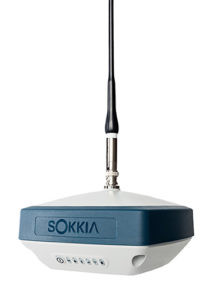
Sokkia introduced the latest addition to its GNSS integrated receiver line — the GRX3. According to the company, the GRX3 is designed to provide a smaller, lighter and fully integrated GNSS solution.
Photo: Sokkia
“The multi-constellation GRX3 receiver is built to offer a complete and versatile solution to provide best-in-class positioning performance for a wide variety of precision applications,” said Alok Srivastava, director of product management.
“Whether using the receiver for GNSS post-processed surveying, or RTK using wireless technologies including network RTK option with a cellular-equipped field computer, a SiteComm RTK rover, or paired with a Sokkia total station for fusion positioning, the GRX3 provides the most advanced and powerful GNSS technology available in a more compact and lightweight housing that can withstand the harshest of environmental conditions. Combine it with one of Sokkia’s data collectors and field software for maximum versatility and convenience, increasing fieldwork efficiency from start to finish.”
The receiver features Sokkia Tilt technology, which includes a 9-axis inertial measurement unit and ultra-compact eCompass designed to compensate for mis-leveled field measurements by as much as 15 degrees.
“The GRX3 is designed as a ‘future-proof’ solution with an advanced GNSS chipset with Universal Tracking Channels technology that automatically tracks signals from all available and planned constellations — including GPS, GLONASS, Galileo, Beidou, IRNSS, QZSS, SBAS,” Srivastava said.
The receiver has been tested to meet IP67 certification for protection against harsh environmental weather conditions.
By William Roberts, Joshua Critchley-Marrows, Marco Fortunato, Maria Ivanovici, Nottingham scientific Ltd., Karel Callewaert, Thiago Tavares, VVA Brussels, Laurent Arzel and Axelle Pomies, Telespazio France
The FLAMINGO initiative is developing the infrastructure, solutions and services to enable use of accurate, precise GNSS in the mass-market, operating predominantly in an urban environment. Whilst mass-market receivers are yet to achieve accuracies below one meter for standard positioning, the introduction of Android raw GNSS measurements and the Broadcom dual frequency chipset present such an opportunity.
FLAMINGO will enable high-accuracy positioning and navigation information on devices such as smartphones and internet of things (IoT) devices by producing a service delivering accuracies of 50 cm (at 95 percent) and better, employing multi-constellation, PPP and RTK mechanisms, power consumption optimisation techniques.
Whereas the Galileo High Accuracy Service targets 10-cm precision for professional users, FLAMINGO targets 50-cm precision for consumers. With accuracies of a few decimetres, a range of improved and new applications in diverse market sectors are introduced, including, but are not limited to, mapping and GIS, autonomous vehicles, augmented reality environments, location-based gaming and people tracking.
To obtain such high accuracies with mass market devices, FLAMINGO must overcome several challenges which are technical, operational and environmental. This includes the hardware capabilities of most mass-market devices, where components such as antennas and processors are prioritised for other purposes. We demonstrate that, despite these challenges, FLAMINGO has the potential to meet the accuracy required. Tests with the current smartphones that provide access to multi-constellation raw measurements (the dual-frequency Xiaomi Mi 8 and single-frequency Samsung S8 and Huawei P10) demonstrate significant improvements to the PVT solution when processing using both RTK and PPP techniques. Check out more information here.
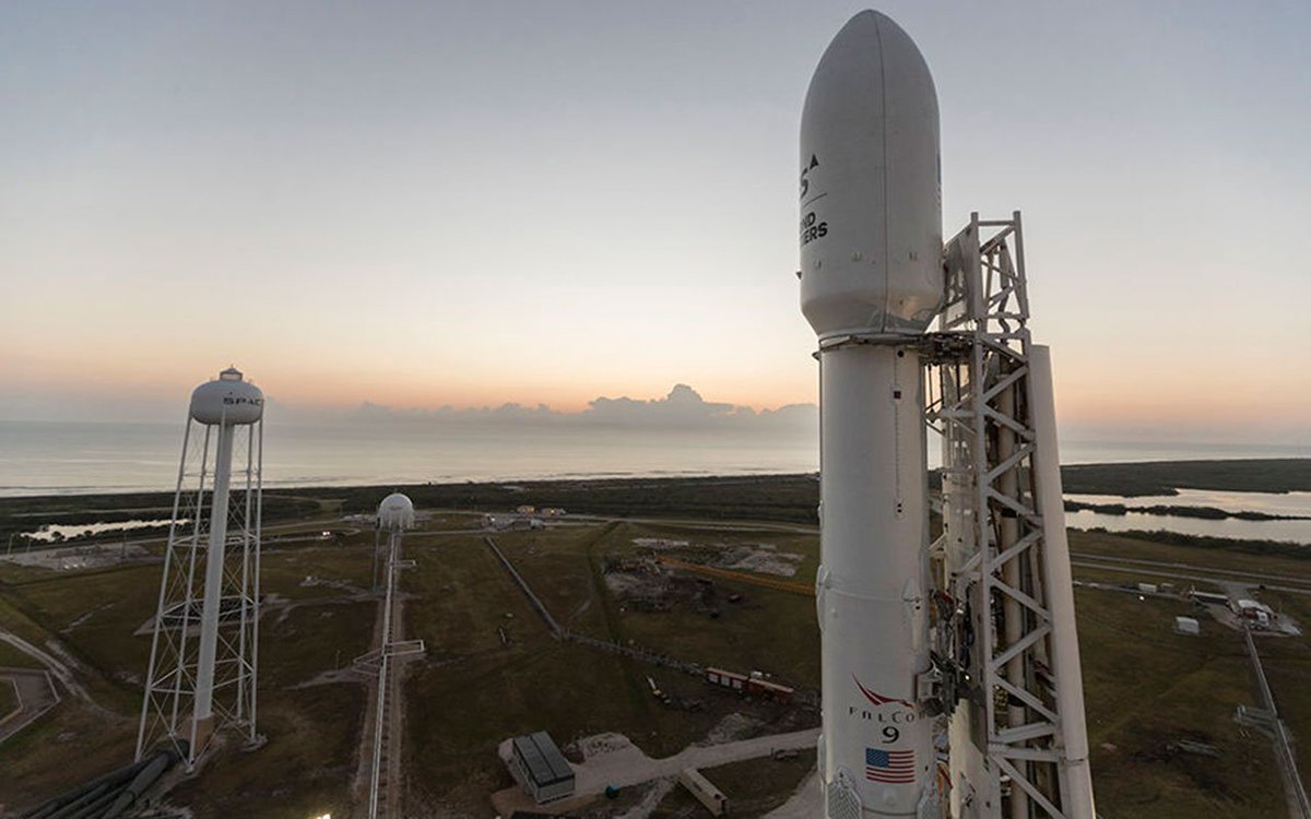
The scheduled launch of the first GPS III satellite on December 18 was scrubbed, reportedly due to first stage liquid oxygen thermal limit constraints aboard the SpaceX Falcon 9 Block 5 launch vehicle’s first stage reaching safety limits. A second attempt on December 19 was later ruled out due to ongoing evaluations into the sensor issue.
The launch window may open again on Dec. 20.
This was to have been the first GPS launch aboard a SpaceX rocket, as well as the first SpaceX contracted U.S. National Security mission.
A Falcon 9 rocket awaits launch. (Photo: SpaceX)
The first GPS III satellite was originally scheduled to ride aboard a United Launch Alliance (ULA) Delta IV M+ rocket. ULA and/or its prime partners, Lockheed-Martin and Boeing, have conducted every GPS satellite launch since the start of the program. However, due to an assortment of issues variously involving delayed technology development and lawsuits regarding competitive bidding, the Air Force re-opened bidding for the contract as part of its Evolved Expendable Launch Vehicle (EELV) program — “evolved” signifying that the rocket can be recovered and reused.
Recycling Rockets. ULA did not bid on the re-opened contract, citing concerns over the selection process and potential risks with the anticipated lower launch cost. In 2016, the Air Force selected SpaceX to take over most GPS III launches.
SpaceX’s Falcon 9 for this launch will use a new first stage core, the B1054. Although it has re-use capability, it will fly in an expendable configuration this time, with no landing legs and no grid fins. It will be disposed of into the Atlantic Ocean after separation from the second stage.
In other missions, after the satellite-bearing stage separates from the rest of the rocket, the remaining core launcher fires additional fuel to return intact to land or to sea aboard an Autonomous Spaceport Drone Ship (ASDS), a converted barge awaiting in the Atlantic or Pacific Ocean.
New Generation of GPS. As attentive readers already know, GPS III SV01 is the first of an entirely new design of GPS satellite that will help the Air Force modernize today’s GPS constellation with new technology and advanced capabilities.
GPS III has three times better accuracy and up to eight times improved anti-jamming capabilities. Spacecraft life will extend to 15 years, 25 percent longer than any of the GPS satellites on-orbit today. GPS III’s new L1C civil signal also will make it the first GPS satellite broadcasting a compatible signal with other international global navigation satellite systems, like Galileo, improving connectivity for civilian users.
Lockheed Martin developed GPS III and manufactured GPS III SV01 at its GPS III Processing Facility near Denver. In September 2017, the Air Force declared the satellite “Available for Launch” (AFL) and had the company place it into storage. In 2018, the Air Force called up the satellite for launch and Lockheed Martin delivered it to Florida on Aug. 20. The Air Force nicknamed the satellite “Vespucci” after Italian explorer, navigator and cartographer Amerigo Vespucci.
GPS III SV01 is the first of 10 GPS III satellites originally ordered by the Air Force. GPS III SV03-08 are now in various stages of assembly and test. In August, the Air Force declared the second GPS III AFL and in November called GPS III SV02 up for 2019 launch.
ION GNSS+ 2019 organizers are accepting abstracts for the conference, which is set to take place Sept. 16-20 in Miami.
The conference, themed, “GNSS + Other Sensors in Today’s Marketplace,” will feature two tracks: the commercial and policy tracks and research track.
The commercial and policy tracks cover mass market and commercial applications, current status and future trends in GNSS, and high performance and safety critical applications. The research track will cover autonomous systems technology, robust multi-sensor navigation and advanced GNSS.
According to show organizers, authors whose abstracts are accepted in these sessions (either as a primary or as an alternate presenter) will have the option to have their paper peer-reviewed.
ION GNSS+ is a technical meeting and showcase of GNSS technology, products and services. The show gathers international leaders in GNSS and related positioning, navigation and timing fields to present new research, introduce new technologies, update current policy, demonstrate products and exchange ideas.
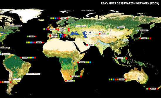
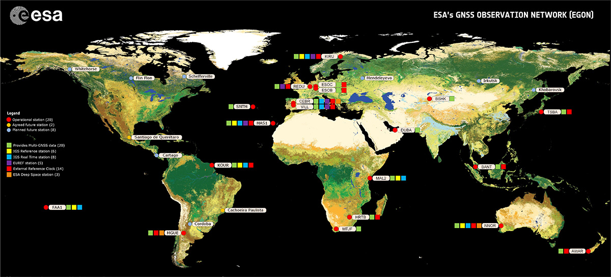
Global satellite navigation systems are continuously bathing Earth in satnav signals. As well as helping in our daily lives, these signals are also tools for cutting-edge science. A new ESA facility, based at ESA’s astronomy centre near Madrid, is championing their use for everything from Earth monitoring to fundamental physics.
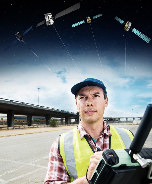
A Surveyor uses a GNSS device to map urban assets with Galileo and EGNOS. (Image: ESA)
The new ESA Global Navigation Satellite Systems (GNSS) Science Support Centre is based at ESA’s European Space Astronomy Centre, ESAC, near Madrid. Run by ESA’s Galileo Science Office, the GSSC integrates IT and satnav infrastructure to deliver advanced data processing services to the scientific community.
Precisely timed to a few billionths of a second and highly stable, satnav signals can be used as a point of reference for many scientific sectors, including Earth and atmospheric sciences, astronomy, highly precise timing metrology as well as the study of relativity and other fundamental physics topics.
Current satnav infrastructure plans worldwide should see more than 120 satnav satellites in orbit in coming years. This number includes Europe’s own Galileo constellation — offering unique features such as its highly stable passive hydrogen maser atomic clocks, multiple transmission frequencies, robust modulation, wide bandwidth and onboard laser retro-reflectors, which permit exact pinpointing of the satellites’ position in space down to a few tens of centimetres.
“The potential of satnav for science has been recognised for a long time,” explains Javier Ventura-Traveset, Head of ESA’s Galileo Science Office. “The Galileo Science Office was set up in 2016 as a joint initiative between ESA’s Science and Navigation Directorates, coordinating scientific opportunities through interaction with the scientific community and the independent GNSS Science Advisory Committee.
“The opening of the new centre is the next step. It is ESA’s concrete answer to the need expressed by the scientific community for a one-stop-shop to offer researchers long-term GNSS data, products information, results of scientific experiments, plus services to enhance GNSS scientific research and collaboration.
“The future evolution of the centre will be driven by the interaction and feedback received from the scientific community, maximizing synergies with other GNSS data service providers from other institutions and research organization.”
Among the activities to be supported by the new GSSC are big data processing of large amounts of satnav data, crowdsourcing as a means of weather monitoring and a scientific assessment of satnav performance in Antarctica.
It also supports the continuing measurements of general relativity using Galileo satellites 5 and 6 and serves as a global data centre for the International GNSS Service. The long-established Navipedia website, giving technical information on satnav, is also hosted by the GSCC.
One enthusiastic early adopter is ESA’s Navigation Support Office, based at ESA’s ESOC mission control centre in Darmstadt, Germany, lending support to mission teams making use of satnav to steer satellites.
“The GSSC is a welcome addition to ESA’s activities in the science of satellite navigation,” says Werner Enderle, heading ESOC’s Navigation Support Office. “The GSSC already hosts GNSS products generated by the team at ESOC, including observations from our worldwide EGON GNSS Observation Network and precise satellite orbits generated by their state-of-the-art software. Our two teams look forward to this collaboration continuing for the benefit of ESA and the scientific community.”
The GSSC will roll out access to data, products and services over the coming months.
The device combines u-blox GNSS, 4G and Wi-Fi technology, eliminating the need to equip vehicles with a separate mobile Wi‑Fi hotspot.
According to the companies, the StartLink TrackerWi‑Fi is suitable for applications for connected cars, telematics, vehicle diagnostics, fleet management, vehicle security, usage-based insurance, and rental and leasing service companies.
The internet of things (IoT) and connected-car initiatives are providing rental car companies and transportation and logistics firms with tools to track vehicles, preemptively detect and diagnose disturbances from a distance, and monitor the behavior of their drivers in real time. ERM has more than 1.8 million vehicle fleet-tracking devices deployed on roads world-wide.
As onboard Wi‑Fi becomes increasingly widespread, many companies are fitting vehicles with Wi‑Fi hotspots to offer drivers and passengers internet access. With its integrated Wi‑Fi hotspot, ERM’s StarLink TrackerWi‑Fi lets users tap into the cellular 4G connectivity to transfer telematics data to the fleet manager. This makes it possible to send real-time telematics data to the driver’s smart device or onboard infotainment system, and it also reduces the number of SIM cards needed from one per device to one per vehicle.
Sourcing the GNSS tracking, cellular 4G LTE, and Wi‑Fi technology from u-blox played a key role in achieving the device’s fast time to market. By using u‑blox’s pre-tested positioning and communications modules with integrated software, the manufacturer was able to cut the time needed for production and development by several months.
“We saw an opportunity to provide more values to our customers by adding Wi‑Fi hot spot functionality to our StarLink Tracker, our leading telematics product, but knew that we had to be quick to stay ahead of the game,” said Kfir Lavi, senior vice president of ERM Advanced Telematics.
“Our partners are always at the top of our priorities, and we are working to adapt our offerings to the market demands and the changing needs of their customers. Working with u‑blox as the provider of the positioning and wireless communication technology helped us move from concept to commercialization in under six months and provide our partners with an advanced product in a short time,” Lavi said.
“This successful collaboration demonstrates that we have evolved from a provider of individual technologies, namely GNSS positioning, cellular 4G connectivity, or short range radio communication, to a provider of solutions that bundle these technologies,” said Thomas Seiler, CEO of u-blox. “We are seeing increased demand for such bundled solutions and are convinced that the close integration of our technology portfolio offers our customers the unique ability to jump-start even challenging projects on extremely short notice.”
Skycatch has announced an on-premise data processing and GNSS base station, the Skycatch Edge1, manufactured in partnership with DJI and now available worldwide.
Edge1 base station. (Photo: Skycatch)
Tested and optimized for the Skycatch Explore1 and DJI Phantom 4 RTK drones, the self-positioning Edge1 allows commercial drone users the ability to process and receive data without the need for internet or cellular connectivity, the company said.
Field teams can fly their drone, process the data and receive centimeter-level data outputs in 30 minutes or less, directly to a tablet. 2D maps and 3D point clouds are available for viewing and sharing directly from the tablet.
The Edge1 concept began as a companion to the Skycatch Explore 1 drone. Now, a new generation of the Edge1 will support all DJI drones, including the recently released DJI Phantom 4 RTK, and will process any 2D geotagged images.
In addition to a survey-grade GNSS base station, the Edge1 includes built-in WiFi, LTE, reliable sub-5-centimeter accuracy, and delivers high-quality data outputs, the company added. Built around a state-of-the-art compute module, the Edge1 is also capable of running deep learning algorithms to extract more insights from collected data in near real time.
“It’s truly a revolutionary product that we’re excited to make available to the DJI community, and the construction and mining industry at large,” said Christian Sanz, founder & CEO of Skycatch. “With the partnership and support of DJI, the Edge1 will be assembled with precision execution in their world-class manufacturing facility, and will be available faster to the customer.”
“As the commercial drone industry has grown, the amount of data collected by our enterprise users is unprecedented,” said Jan Gasparic, director of strategic partnerships at DJI. “We are glad to work with Skycatch to manufacture the Skycatch Edge1 GNSS base receiver, enabling enterprise customers, especially those in the construction industry, to process data from their DJI drones on-site and in real-time.”
Skycatch is an industrial data collection and analytics company focused on indexing and extracting critical information from the physical world, using a combination of hardware, software and artificial intelligence. Built for enterprise, its turnkey solutions are deployed across global project sites with largest construction, mining and energy companies.
Cohda Wireless has successfully demonstrated its connected autonomous vehicle technology in a live trial on the streets of the city of Adelaide, Australia.
The trial proved the potential for connected self-driven vehicles to make streets safer and that Cohda’s technology is effective even in challenging urban canyons.
In an area covering two city blocks east of Adelaide’s Victoria Square, the demonstration replicated a scenario that is a daily occurrence on the streets of cities all over the world.
In the scenario, two vehicles approach a four-way intersection at right angles to each other. Car 2, driven by a human, fails to adhere to the red-light signal and approaches the intersection at speed, intending to “skip” the red light. Car 1, a connected autonomous vehicle, is approaching the intersection from another direction and intends to proceed through the intersection on the green light.
In a real-life scenario, there would be a risk of a collision as human drivers will invariably approach the intersection when the light is green, fully confident that all other road users will obey the traffic signals. In an instance where Car 2 disobeyed the traffic signal and Car 1 was unable to see the approaching danger, due to visibility being obstructed by buildings or other infrastructure, a collision would be especially likely.
But as Cohda Wireless’s Chief Technical Officer Professor Paul Alexander explained, if the vehicles were connected using Cohda’s V2X (Vehicle-To-Everything) technology, a potential collision situation would be detected and avoided well in advance of it actually happening.
“We demonstrated that when vehicles are connected to each other using our smart V2X technology, Car 1, the connected autonomous vehicle, would detect that Car 2 is approaching the red light at speed and is probably not going to stop. This allows the connected autonomous vehicle to pre-emptively identify and respond to the threat by slowing down and stopping.”
“Cohda’s V2X technology allows vehicles to ‘speak to each other’ to extend their perception horizon,” added Alexander.
“The technology provides the vehicle with an awareness of its environment and risk factors associated with it, consistently and accurately up to ten times per second, enabling it to make decisions that a human being would not be capable of making as the driver of the vehicle.”
Cohda’s Smart Cars Smart City initiative was funded by the South Australian Department of Transport and Infrastructure’s Future Mobility Lab Fund. In June this year, Cohda Wireless took ownership of two specially-modified vehicles from the U.S. that it is using in advanced trials of its V2X (Vehicle-To-Everything) technology.
The two Lincoln MKZ sedans were fitted with the ADAS (Advanced Driver Assistance Systems), ROS (Robot Operating System) various sensors including lidar, radar, cameras, GPS as well as in-vehicle compute platform and Cohda’s GNSS- independent positioning technology.
The fusion and cooperation of the various sensors and Cohda’s V2X technology augment the vehicles’ perception capability and make the autonomous vehicles features more practical, to include threat detection, the dangers associated with blind intersections and vulnerable road users, the company said.
“Our goal today was not only to demonstrate the efficacy of our technology in enabling self-driven vehicles to communicate with each other, but also to do so in a city environment where so-called ‘urban canyons’ significantly affect the ability of systems reliant on Global Navigation Satellite Systems (GNSS) to achieve accurate positioning,” Alexander said.
“The area in the city of Adelaide in which the trial was conducted was one such urban canyon where positioning through GNSS can be off by up to 40 meters, but with our V2X Locate technology positioning accuracy is improved to within a meter.”
Photo: Cohda Wireless
Cohda Wireless demonstrated the efficacy and accuracy of its V2X-Locate system in a 2017 trial in New York City where it repeatedly demonstrated sub-meter accuracy while driving along Sixth Avenue, which has the tallest buildings in the Big Apple. Comparably tested GPS-based systems were as much as tens of meters off-course, at times showing cars driving through buildings.
Cohda’s V2X technology underpins and complements other technology used by autonomous vehicles such as cameras, sensors, radars and lidars by enabling cooperative perception.
“The role of technology in making our roads safer is probably not generally understood but we hope that this demonstration has helped to prove that with the appropriate technology and infrastructure, connected self-driving vehicles are safer to have on our roads than vehicles controlled entirely by human beings,” added Alexander.
An Air Force professor was honored for years of work exploring every PNT technology imaginable in conjunction with GPS; Rockwell Collins launched a new MicroSTRIKE multi-GNSS chip for military and professional applications, available globally on a non-ITAR basis; and Spirent Federal previewed its SimMNSA, a new M-code simulation option delivering to authorized customers by the end of the year.
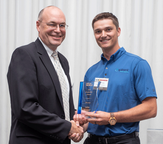
John Raquet, AFIT, accepts 2018 Leadership Award for Services from Justin Eldredge, Spirent Federal. (Photo: Melanie Beus)
John Raquet, a professor in the Department of Electrical and Computer Engineering at the Air Force Institute of Technology, received the 2018 Leadership Award for Services. Raquet was recognized for work he and his team at the Autonomy & Navigation Technology (ANT) Center developed on PNT sensors and systems utilizing almost every available source, including GPS, GNSS, inertial, vision, lidar, magnetic field, pseudolites, radar, terrain mapping, signals of opportunity, star trackers, radio ranging, 3D audio, X-ray pulsars, clocks, and more.
Raquet has co-authored many defense-oriented technical papers over the past three decades. See the list at the end of this article for some of the most recent ones.
Justin Eldredge from Spirent Federal introduced Raquet and bestowed the award, after updating the audience on Spirent’s most recent advance: “This year we maintain our position of being first to market with new signals, with the launch of SimMNSA. We’re currently in the final test phase of this new M-code option and it will delivering to several authorized customers by the end of the year. If M-code signals aren’t in the spectrum of testing for you, we offer products that simulate all other GNSS signals, plus a variety of other sensors.”
SimMNSA was demo’d at the Spirent Federal Systems booth at the neighboring ION GNSS+ conference. A video presentation of SimMNSA (for Modernized Navstar Security Algorithm) is available here. Spirent’s new software will support M-code using MNSA. M-code is an updated GPS military signal that is being rolled out as part of the modernization of the current GPS constellation. Until now, AES and SDS have been the only methods authorized to be used within a GNSS simulator to produce M-code. As the long-awaited MNSA M-code signals become available, Spirent Federal Systems will make this capability available to authorized users on the GSS9000 series simulator.
ANT
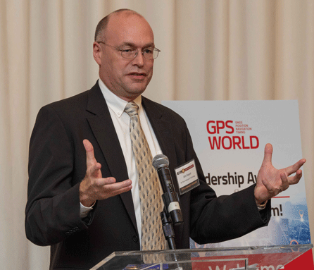
After receiving the 2018 Leadership Award, Raquet spoke about his work at theAutonomy & Navigation Technology Center. “Sometimes I called the ANT the Crazy Idea Factory. We’ve tried lots and lots of things. I think I have the best job in the world, because I get to experiment with many, many things, and work with amazing people.”
John Raquet, U.S. Air Force Institute of Technology (Photo: Melanie Beus)
“This is not the kind of community where you build something once and you’re done, you put it away. This is a growing worldwide enterprise that takes new talent to come in and fill the spots that many of the people in this room have occupied. I’m privileged to see some of the students that we’ve worked with to then go on and fill some of the gaps, really do some amazing things.”
MicroSTRIKE, a non-ITAR GPS chip
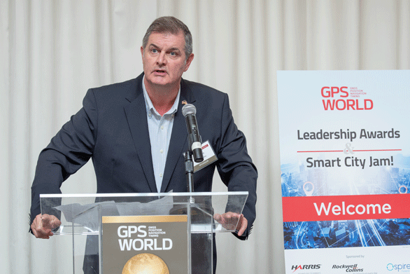
Two awards prior to Raquet’s Services award, Phil Froom from Rockwell Collins, UK, spoke about an innovative venture from Rockwell and partners QinetiQ UK as he bestowed the Satellites award.
“For many years most of you here this evening will have known Rockwell Collins as a reliable partner in the delivery of Secure (encrypted) GPS receiver, and indeed, we are still the largest producer of encrypted military GPS solutions in the world. Our partners QinetiQ also have great expertise in the design and delivery of high assurance low SWAP GPS receivers, bringing together many years of expertise of our two companies in this new venture.
Phil Froom, business development lead for Rockwell Collins, Europe, Middle East and Asia (Photo: Melanie Beus)
“However, over the past few years we have seen our military and professional (government) users looking to greater flexibility in their use of GNSS, as new capabilities and constellations come on line. But with that flexibility, a retention of assurance and where possible, mitigation of threats. For this reason, last May, Rockwell Collins and QinetiQ signed an Alliance Agreement in London, to produce a new family of high-assurance, multi-constellation GNSS receivers for professional and military use.
“This new family of receivers is aimed to be complementary to the current encrypted family of Rockwell Collins receivers in service across the globe, but allow the customer to select his level of capability and protection based upon his operational, political or even financial needs. The new “MICRO” family of GNSS receivers will offer a multi-constellation open service (MCOS) GNSS capability, which will initially provide two receivers; the first, to be known as the Q40-MicroPNT, will address dismounted low dynamics requirements, and the second, the Q40-MicroSTRIKE, will be a gun hard, high dynamics receiver.
“You will note I said they are MCOS receivers. Therefore, they will not include an encryption device, will be Non-ITAR and will actually be produced in Europe, under the control of Rockwell Collins UK. QinetiQ are today working on the Q40 ASIC and, once available, this will be incorporated into these first two Micro Family receivers.
“These receivers will be of a common format to our existing and highly successful SAASM based MicroGRAM receivers and will offer users and OEMs the ability to select an MCOS receiver, or a SAASM (or ultimately M-Code) receiver, of a common form – factor, to meet their mission or platform needs. Thus allowing OEMs to reduce costs in integrating different form-factors, and to allow users to hold common hardware, but mounting mission specific receivers.
“We are of course extremely excited about this Alliance with QinetiQ and equally by the prospect of what it will bring to our existing and future users as we all move forward into this new era of GNSS capability.”
Check out videos from the event below. Click on the icon in the top left hand corner to choose which video you’d like to watch.
Recent technical papers co-authored by John Raquet.
• “Magnetic field navigation in an indoor environment,” Ubiquitous Positioning Indoor Navigation and Location Based Service, (Aiding an inertial navigation system when GNSS signals are not available, by taking advantage of the uniqueness of magnetic field variations);
• “Comparison of two image and inertial sensor fusion techniques for navigation in unmapped environments,” IEEE Transactions on Aerospace and Electronic Systems, (navigation of miniature aerial vehicles (MAVs) couplimng information from an IMU with visual information from an electro-optical camera);
• “Real-time UWB-OFDM radar-based navigation in unknown terrain,” IEEE Transactions on Aerospace and Electronic Systems (a signal processing algorithm and simulation study for aerial navigation with an ultrawideband orthogonal frequency division multiplexed (UWB-OFDM) radar in GPS-denied environments;
• “Navigation in GPS denied environments: Feature-aided inertial systems,” Air Force Research Lab, Eglin AFB FL Munitions Directorate (latest alt-nav trends for navigating in difficult urban, indoor, and underground environments where typical GPS receivers do not function;
• “Coded aperture aided navigation and geolocation systems,” US Patent office #8577539 (A micro air vehicle having a navigation system with a single camera to determine position and attitude of the vehicle using changes the direction to the observed features);
• “Multisensor navigation systems: A remedy for GNSS vulnerabilities?” Proceedings of the IEEE (A multisensor navigation approach to GNSS-challenged environments using inertial measurement units (IMUs), barometers, magnetometers, odometers, and digital compasses);
• “Large scale image aided navigation,” IEEE Transactions on Aerospace and Electronic Systems (images from an airborne camera match features against a reference image to compute global position);
• and many more.
The Institute of Navigation presents Yu Jiao with the Parkinson Award at ION GNSS+ 2018. (Photo: ION)
Yu Jiao was recognized for graduate student excellence in GNSS by the Institute of Navigation’s (ION) Satellite Division on Sept. 28 at the ION GNSS+ Conference in Miami. She received the Bradford W. Parkinson Award for her thesis, “Low-Latitude Ionospheric Scintillation Signal Simulation, Characterization and Detection on GPS Signals.”
Jiao received her Ph.D. at Colorado State University, with Jade Morton as her advisor. She graduated this past year and is now employed as a GNSS engineer at Intel.
The Bradford W. Parkinson Award is granted annually to recognize an outstanding graduate student in GNSS, and is presented in honor of Bradford W. Parkinson for his leadership in establishing the U.S. Global Positioning System and for his work on behalf of the Satellite Division of the Institute of Navigation.
Any graduate student who is a member of the ION and is completing a degree program with an emphasis in GNSS technology, applications or policy is eligible for the award.
ThinkRF Corp., a software-defined spectrum analysis solution provider, has released the ThinkRF R5700 Real-Time Spectrum Analyzer with GNSS.
Unlike other handheld portable spectrum analyzers, the ThinkRF R5700 analyzer combines the performance needed to cover the 27-GHz frequency range with the portability and form-factor required to be easily used in a vehicle.
“This solution allows users to conduct advanced analysis in a variety of deployment scenarios, including in a vehicle for drive testing and other mobile testing applications,” said Jasvinder Obhi, vice president of product management and marketing at ThinkRF. “Combined with our application ecosystem, users get a complete mobile situational awareness solution with the best price-performance ratio available on the market.”
To accompany the R5700 analyzer, ThinkRF has also released the ThinkRF P120 vehicular power conditioner. It is designed to provide regulated power to portable equipment while protecting from vehicular power transients This allows spectrum analysis equipment, including all ThinkRF real-time spectrum analyzers, to be powered in standard vehicles via power outlets or directly from the vehicle battery.
According to the company, when combined, the two products enable advanced mobile spectrum analysis and drive testing capabilities for RF engineers and monitoring program managers in government, aerospace and defense, and telecommunications.
The ThinkRF R5700 analyzer and ThinkRF P120 conditioner are available to order immediately.
Polynesian Exploration Inc. has introduced its PolyNav 2000P, a high-accuracy navigation solution for emerging applications such as autonomous driving and UAVs.
According to the company, PolyNav 2000P is designed to fully utilize the advantages of both GNSS and inertial navigation systems to provide centimeter-level position and velocity accuracy with dual-frequency real-time kinematic technology, with simultaneously accurate attitude information (roll, pitch and heading).
Polynesian Exploration demonstrated the PolyNav 2000P at ION GNSS+, which was held Sept. 24-28 in Miami.
The PolyNav 2000P system is ultra-stable in terms of short-time satellite signal outages and capable of providing highly accurate heading information no matter whether the system is static or moving, the company said. It is also packaged with a rugged and waterproof enclosure for applications in severe environment conditions.
Options are available to meet various customer requirements, which include, but are not limited to, up to 100-Hz position, velocity, attitude outputs, and meters to centimeter-level position accuracy. They can also be operational in all weather conditions and will be available globally.
The company is able to integrate special sensors such as lidar and cameras for each unique application as requested by customers.