The MCMF GNSS platform combines CMC’s certification with the digital signal processing expertise of Hexagon | NovAtel. Designed to detect GNSS signal spoofing, it islightweight and compact.
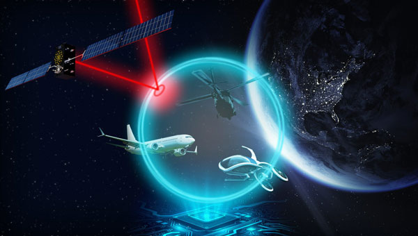
The increasing threat of GNSS signal jamming and spoofing is not limited to military concerns. It has started to impact global commercial aviation and civilian sectors as well. In response, CMC Electronics and Hexagon | NovAtel seek to introduce a new era of MCMF GNSS positioning and assured positioning, navigation and timing (APNT). The collaboration aims to provide maximum reliability and dependability in solutions for the military, commercial aviation and unmanned aerial systems (UAS) sectors.
Under the partnership, CMC Electronics’ new receiver, which is certified to the exacting DO-254 Level A standards, is integrated with Hexagon | NovAtel’s GNSS measurement technology.
Based in Montreal, Canada, with additional facilities in the U.S., CMC Electronics designs and manufactures cockpit systems integration, avionics, display solutions and high-performance microelectronics for the military and commercial aviation markets. Hexagon’s Autonomy & Positioning division delivers comprehensive solutions for assured positioning across various applications, designed to progress autonomous technologies in essential industries.
Hexagon’s Autonomy & Positioning division and Munhwa Broadcasting Corporation (MBC) have partnered to bring precise positioning to South Korea through the TerraStar-X Enterprise Correction Service. The hardware-agnostic correction service provides instant convergence and lane-level accuracy in automotive, mobile and autonomous applications.
As a leader in real-time kinematic (RTK) positioning across South Korea, MBC’s atmospheric data enhances the redundancy of Hexagon’s fast converging and reliable precise point positioning (PPP) network across the country. Through this collaboration, the TerraStar-X Enterprise service is now supported in testbeds across South Korea, China, Japan, Europe, and North America to accelerate development for advanced driver assistance systems, safety-critical applications, micromobility, industrial and smartphone applications.
“With TerraStar-X Enterprise Correction Services now available across autonomous and consumer market applications, developers can design once and then deploy that design at scale worldwide,” said Paul Verlaine Gakne, positioning services product manager at Hexagon’s Autonomy & Positioning division. “TerraStar-X Enterprise is designed to be as flexible as possible for large-scale testing and deployment.”
JAVAD GNSS’ Triump-1M Plus receiver has 874 channels for acquiring all available GNSS satellites and patented mobile antenna technology for robust UHF and cellular communications. (Image: JAVAD)
As most readers of this magazine know, GPS, like the other three GNSS, consists of three segments: the space segment — i.e., the satellites; the control segment — i.e., the monitoring and control stations on the ground around the world; and the user segment — i.e., the receivers. The first two are developed, operated and maintained by the U.S. Space Force, while the third one, for civilians, is totally in the hands of the private sector.
Most of the progress in receivers is evolutionary, with rare dramatic changes. To provide a snapshot of the current state of GNSS receivers, I asked several manufacturers three questions. What follows are short, etre dited excerpts of their answers that showcase the applications of GNSS receivers in a wide range of industries.
What is one of the most recent end-user applications for your receivers? What challenges does it pose and how do your receivers address them?
Sarah Alban (SA): Eos Positioning Systems is lucky to have innovative customers who span a variety of industries. In just these past few weeks, we’ve connected to customers who are using Arrow Series GNSS receivers to meet myriad business needs. Here are just a few examples: On the Caribbean island of Martinique, Odyssi uses an Arrow 100+ with RTK to get accurate water utility locations in a challenging environment. In Texas, midstream pipeline operator Kinetik and its GIS Manager Papillon Romero equip their field workers with an Arrow Gold to update the locations of previously unreliable legacy as-builts. In the Galápagos Islands, a researcher has been using the Arrow Gold+ and Galileo High Accuracy Service (HAS) to georeference drone imagery. In Colorado, GIS specialist Jim Casey uses an Arrow Gold to bring to life a Japanese internment camp in augmented reality.
Simon Baksh (SB): One of our customers is a leading construction contractor who uses our DELTA GNSS receiver for monitoring during deep crack grouting deformation to ensure that the natural state of the ground remains undisturbed during remedial work.
Stephen Ching (SC): One of the most exciting projects happening within Hexagon’s Autonomy & Positioning division is the automated road train platooning application within the mining industry. Transporting raw materials, iron ore in this case, has posed a huge challenge in terms of drivers’ safety, labor shortages and rising fuel costs. Our division is currently developing an autonomous hauling system that solves this challenge by integrating drive-by-wire, perception, positioning and path planning technologies. Our positioning system utilizes a PwrPak7D-E2 plus TerraStar-C PRO solution from Hexagon | NovAtel, which incorporates GNSS+INS technology and real-time kinematic (RTK) From the Sky technology.
Mobile mapping systems such as the Trimble MX50 allow survey companies to safely and accurately gather point cloud and immersive imagery of roads without the need to put a surveyor in the field. (Image: Trimble)
Karl Bradshaw (KB): Traditional survey methods or tripod-based scanning on highways can be time-consuming and dangerous. Survey companies do not want to put surveyors in danger of traffic while traversing along a road. Mobile mapping allows them to safely, accurately and productively gather detailed point cloud and immersive imagery of highways without needing to put a surveyor in the field.
Oreste Concepito (OC): At u-blox, we have seen an increasing demand for GNSS receivers to be used for advanced driver-assistance systems (ADAS) applications and for mobile robotics (such as robotic lawnmowers). GNSS technology is adopted when an accurate, trustworthy position with high availability is required. In the autonomous operations domain, customers are constantly pushing u-blox to improve dependability while maintaining or ideally improving position accuracy, even in challenging environments.
François Freulon (FF): One of our most recent end-user applications is related to resilient timing for mission-critical infrastructure, including finance, data centers, energy and telecommunications. The relevant Septentrio product is the mosaic-T. The recent addition of the AtomiChron timing service further enhances its timing precision, GNSS resilience and anti-spoofing by offering navigation message authentication (NMA) on all for GNSS constellations. The first customer integrating this technology is Meinberg.
Miles Ware (MW): The Galileo High Accuracy Service (HAS) has created new interest in a traditional GNSS market, GIS and mapping, in which the availability of global 20 cm accuracy is turning many heads. While there are many technologies to improve accuracy for this market, few are appropriate. Often the work takes place in remote areas where cellular connectivity is not available for delivering corrections. They may also be in regions of the world where satellite-based augmentation systems (SBAS) are not available or able to meet performance expectations. Galileo HAS resolves both of these concerns. We now support it in our Phantom and Vega receivers.
In the past few years, we have seen the completion of two new GNSS constellations and a large increase in the options for corrections services. How has this impacted the design and/or features of your receivers?
SB: Our 874 channel TRIUMPH ASIC design has capacity for all constellations and signals to utilize current and future GNSS technologies. Additionally, our J-Star PPP Service using geostationary satellite broadcast for global delivery and cm level positioning extends operations to remote areas where networks are absent or where a base station setup and operation is not feasible.
SC: With BeiDou and Galileo in addition to GPS and GLONASS, there can be upward of 40 satellites in view — compared to 20 years ago when having 10 or 12 satellites in view was considered good availability. This gives much more choice as to which measurements contribute to a position solution, provided that the receiver can make measurements to all the satellites in view. Hexagon | NovAtel’s OEM7 was designed to support all GNSS constellations and frequencies, which required supporting many channels as well. The benefits of more satellites in the sky come under challenging conditions with many obstructions and strengthened positioning geometry in unobstructed conditions. In addition to more satellites, BeiDou and Galileo also introduced a new frequency at E6/B3, in addition to L1/L2/L5, which is particularly useful in global PPP solutions, such as RTK From the Sky and TerraStar C-PRO Correction Services.
KB: We have onboarded these constellations into our mobile mapping portfolio in the same way as all other Trimble GNSS portfolios, through rigorous, tried and tested methodologies.
FF: Septentrio receivers already support all GNSS constellations for high precision and resilient positioning. We have added Galileo E6 support and OSNMA, BeiDou phase III satellites (PRN>37) and other new signals (B3I, B2b) to our products through our latest firmware releases. We are also contributing to the large increase of corrections services by providing the backend core technology through our base station receivers or reference receivers. For example, the PolaRx5 reference receivers are used worldwide in many correction network infrastructures. With the support of all in view constellations and signals, Septentrio products are becoming part of critical infrastructure. Therefore, it is essential they have reliable continuous operation as well as security to protect them from potential jamming or spoofing attacks. Additionally, Septentrio has recently launched the Agnostic Corrections Partner Program to help customers find their way in the growing maze of correction offerings and to facilitate the integration of the right service into their system.
Geneq Inc. employee Alex Arsenault operating an SXblue Platinum receiver in Anjou, Montreal. (Image: Nikita Sapeguine / Geneq)
OC: Our customers are increasingly operating in a global market. To respond to that need, u-blox receivers support both the global and the regional constellations, such as Japan’s Quasi-Zenith Satellite System (QZSS) and India’s Indian Regional Navigation Satellite System (IRNSS, aka NavIC). The offer for correction services has also evolved to be able to serve the global market, moving toward uni-directional streams, possibly distributed via L-band. We support a complete portfolio of correction services, responding to all commercial and performance requirements, from the soon available, free-of-charge, lower accuracy correction services, up to the dm-level functional safety-certified correction services for autonomous driving.
MW: Since 2019, our core receiver technology has been intrinsically both multi-GNSS and multi-frequency by design. This allows our engineering team members to rapidly adapt to new and emerging solutions, and for Hemisphere to meet user and market demands. Hemisphere has also worked with our integrators to recognize the need to simplify the decision process around selecting receivers. While it is possible to configure our receivers to track specific constellations only, Phantom and Vega are being offered with multi-GNSS as standard. Similarly, clients can choose L1-only, or all-frequencies. This is why many integrators will quickly be able to take advantage of Galileo HAS.
RP: We have upgraded our SXblueGPS receivers with new GPS chips and with firmware updates to keep up with the new constellations available. Regarding the new correction services, the SXblueGPS have used and use by default the SBAS correction service and its associated networks throughout the planet to improve their precision. Where correction services via internet or SBAS do not exist, they use L-band correction services to have global coverage. In some cases, for topography base and mobile solutions, UHF links provide a customized correction service.
Are jamming and spoofing significant challenges in your key markets? If so, how do you address them?
SB: Yes, and AJ/AS expands on existing RAIM for assured position quality. Patented anti-jamming and anti-spoofing techniques identify and suppress GNSS interference, while maintaining navigation from good signals. Updated firmware for Navigation Message Authentication extends AJ/AS protection further.
SC: GNSS interference such as jamming and spoofing do present significant positioning challenges in many of our markets, especially defense, marine and autonomy applications in which safety and 24-7 operation are paramount. How often GNSS interference happens (and is detected) and how seriously it affects the application depends on the market. It is a threat that can be mitigated by well-designed user equipment. Hexagon | NovAtel has developed a comprehensive GNSS resiliency portfolio to assure that our users’ position is protected with our interference mitigation technology, starting from the GAJT antennas all the way down to the receiver level. NovAtel’s OEM7 receivers include our GNSS Resilience and Integrity Technology (GRIT) firmware options, which provides spoofing detection, interference detection, and mitigation with digital filters, as well as time-tagged digitized samples for advanced situational awareness.
KB: As it applies to mobile mapping with the Trimble MX50, jamming and spoofing are not significant challenges.
OC: A team of engineers is constantly improving our anti-jamming and anti-spoofing technology. U-blox customers are today more mindful of the risks associated with GNSS interference, both intentional and unintentional. GNSS is adopted in critical infrastructures and autonomous vehicles, where jamming and spoofing could lead to severe consequences. While no system can be safe in absolute terms, increasing the sources of information can greatly improve the resilience against jamming and spoofing attacks. Multi-constellation GNSS receivers, multi-band constellations, inertial sensors and accelerometers, can all be individually used as additional safety layers contributing to a more robust solution. Additional measurements are implemented at the positioning engine level, as part of our functional safety program. The availability of authenticated signals, being introduced by Galileo’s Open Service – Navigation Message Authentication (OS-NMA), will also contribute to increasing the GNSS robustness against interference.
Hemisphere GNSS’ GradeMetrix is a machine guidance solution for GNSS-based machine control and guidance applications. (Image: Hemisphere)
FF: Definitely, and we are seeing a large increase in demand for resilience in many applications and for assured positioning, navigation and timing (PNT). Providing trustworthy information is critical now for many markets, such as machine control, robotics, timing, infrastructure and assured PNT. Our multi-frequency multi-constellation GNSS technology not only maximizes accuracy and availability in areas where the sky is partially obstructed, but also provides extra resilience against jamming and spoofing. All our GNSS receivers are resilient to jamming and spoofing thanks to the built-in Advanced Interference Mitigation (AIM+) technology, which suppresses the widest variety of interferers, from simple continuous narrow-band signals to the most complex wideband and pulsed transmissions.
MW: Fortunately, jamming and spoofing are not common occurrences in most of our markets. However, their nature is such that they can appear at any time, in any place, without warning. This can cause otherwise routine plans for users to suddenly grind to a halt. Hemisphere’s Cygnus interference solution provides protection against up to 60 dB of jamming and is built into our current generation products by default. Having Cygnus available can make the difference between working normally and searching for alternate solutions. A welcome tool offered through Galileo satellites is OS-NMA signal verification, which provides excellent protection against spoofing attacks. Firmware updates provide our current product platforms access to OS-NMA spoofing protection. As our standard products are already activated for multi-constellation operation, it simplifies integration for our users.
RP: Interference is inevitable given the enormous number of signals from telephone and electrical networks, among others, as well as buildings, trees and, of course, the weather. To mitigate this, we use multi-frequency and multi-GNSS antennas that allow us to obtain the best reception in areas of interference. Additionally, we have state-of-the-art GPS chips that block and purify signals that generate distortion. On the other hand, there is interference by intentional GNSS falsifications or by radio amateurs who transmit radio signals for drones and other devices that cause GPS signal loss, which are mitigated by the latest technology algorithms of our SXblueGPS.
It has been a wild decade, with so many players in the autonomous vehicle (AV) market, all striving for a leg up. Until the dominant design of present AV stacks emerged, there was no small amount of experimentation and less-than-successful alternate approaches. For instance, there was one big-name player that initially sought to create an AV solution without GNSS. Reality set in, and they soon embraced GNSS as an essential component.
Gordon Heidinger, segment manager, automotive and safety critical systems at Hexagon’s Autonomy and Positioning division, has had a front-row seat from which to observe, and contribute to the evolution of AV.
“I’ve been in the automotive industry for 20 years, all the way from OEMs like Chrysler to tier ones like Harman,” Heidinger said. “I’ve worked on the engineering side, on the project management side, and have now joined Hexagon | NovAtel to help further their involvement in the automotive industry. NovAtel was there for aviation 20 years ago, helping develop systems for planes to take off and land autonomously — we have a deep bench when it comes to applying such expertise for vehicular autonomy.”
NovAtel has long provided GNSS and IMU products and solutions, as well as real-time positioning services. Each are key elements of AV sensor stacks and overall autonomy solutions. Parent company Hexagon has multiple divisions contributing to intelligent transportation — on both the front end and back end.
The Front End
AV systems require highly reliable and smart sensor stacks that typically include cameras, radar, lidar and sonic sensors; these provide the relative positioning for advanced driver assistance systems (ADAS), which are becoming commonplace for newer vehicles. There are also implementations that include GNSS/IMU for navigation and lane keeping.
“Lane keeping is possible to a limited degree with combinations of the other sensors; however, you need GNSS to let you know where you truly are for autonomous driving,” Heidinger said. “Are you on the right freeway lane in Ottawa, or is this an exit ramp? This was a big problem with today’s simple single frequency solution; a car can assume highway speeds on an exit ramp, not realizing it was an exit ramp.”
Only with the absolute precise positioning that GNSS provides, and a high-definition map, level 4 autonomy — and potentially level 5 someday — could be achieved. With current sensor stacks, when the car is moving, it can reliably detect the other cars moving in its vicinity. Furthermore, vehicle-to-vehicle (V2V) solutions are being developed and tested, which enable a vehicle to share data about where it is going, its speed and acceleration, and its current location. We may remain far from full autonomy until such solutions are broadly deployed, however we will see some of the vehicle-to-everything (V2X) solutions sooner than later.
Various developers and departments of transportation around the world are testing short range V2X communication systems.
“We would need real-time construction zone updates,” Heidinger said. “It would be tough to do lane keeping if a construction site closes or diverts lanes during the course of a day. Or if cameras detect crashes, or blocked lanes, this will need to be broadcast immediately and continuously in real-time.”
A representative example of a production high precision positioning system was demonstrated at the recent Consumer Electronics Show 2023 (CES 2023). ZF Friedrichshafen AG (ZF) has developed ProConnect — a dedicated short-range communication (DSRC) solution that enables positioning and communication for use in applications with roadside infrastructure, such as traffic lights. It can be scaled to include other over-the-air alerts that could include first responder vehicle proximity and construction site status. At CES, the GNSS positioning was demonstrated with an autonomous vehicle platform from Hexagon.
“The precise map and the real-time updates from V2V and V2X systems all need precise absolute positions to relate objects to each other,” Heidinger stated. The question then becomes “…how reliable and trustworthy is that solution”?
There are international automotive-grade requirements such as the ISO 26262 standard for electrical/electronic systems, and automotive safety integrity levels. For instance, ASIL-B(D), and cybersecurity standard ISO/SAE 21434. The latter provides protection against external access without authorization.
“The level of reliability required is extremely high,” Heidinger said. “After all, these are human lives, in metal boxes hurtling along at highways speeds. There are ASIL standards that call for a probability of 10-8, or 1 in 100 million, in an hour that the system is wrong. These levels of reliability need to apply to electronic components, communications, and the availability of the GNSS positioning solution to really automate any type of vehicles. You’ll encounter similar AV standard references to five-nines, or 99.999%.”
Positioning Services
Heidinger explained that for most aspects of autonomy, GNSS can be “good enough”, even just to a foot. However, uncorrected, GNSS can never meet even those needs — achieving an accuracy of a few meters at best. Then there is the matter of reliability. Augmentations like real-time kinematics (RTK) and precise point positioning (PPP) apply broadcast “correctors” that can yield centimeter positions. RTK is not practical for broad areas or highway and road networks as it requires dense infrastructure and two-way communication with the vehicle, which can introduce security challenges.
Solutions for autonomy are typically PPP. While there are many applications of PPP that use clock, orbit and ionospheric model data broadcast from geostationary L-band satellites, for applications such as surveying, mapping, maritime and agriculture, this would not meet the reliability requirements for AV. The Achilles heel of broadcast PPP is that the satellites are usually limited in number and positioned over the equator; the vehicle can often lose sight of these. Instead, PPP services, such as that provided by NovAtel and others, are tapped by vehicles via mobile internet connections; this means cellular networks. While cellular services can often meet reliability goals, there are still vast areas of highways where availability is sparse.
The other challenge for PPP is the convergence time needed to get reliable sub-foot precision.
“No one wants to wait five minutes or more for it to converge,” Heidinger said. “By processing data from semi-dense networks of reference receivers, our PPP can converge rapidly enough to be ready to roll as soon as you start driving.”
The Back End
A free-for-all of autonomy is not going to happen on highways and roads that are not precisely mapped and kept up to date.
“There are visions of crowd sourcing map updates from the sensors in cars,” Heidinger said.
Crowd-sourced data is not systematic enough, though, and could be inconsistent. After all, there are privacy considerations, and how many vehicle owners would be willing enough to participate?
There are numerous mapping and imaging “buggies” plying road and highway networks on an ongoing basis; this could provide a base layer. But how precise? The specific applications these mapping buggies support may not need high precision. And operators may not be willing to invest in high precision/accuracy. The precision of the 3D maps would need to be higher than the target range of the AV systems. The technology exists and is broadly used for various applications in the form of centimeter precision 3D mobile mapping — at highway speeds. Such systems with lidar scanners, cameras, and positioning solutions can include GNSS, IMU, wheel speed encoders, and SLAM lidar for enhanced position stabilization. An example is the Pegasus TRK from Hexagon | Leica Geosystems.
GNSS is the key component — the provider of precise absolute positioning. When people drive, they are the sensor stack, and they are (mostly) aware of the context of where they are and can see and hear what is going on around them. Before we can hand over the driving duties to machines, and fully accept any autonomous driving technology, it will not only need to be as smart and aware as humans, but much better and more aware than humans. Autonomy sensor stacks can tell a car what it is doing, and what other things are doing in its immediate vicinity, but without a precise map, and knowing precisely where it is in real-time, a car would be still tip-toeing around in a fog of uncertainty.
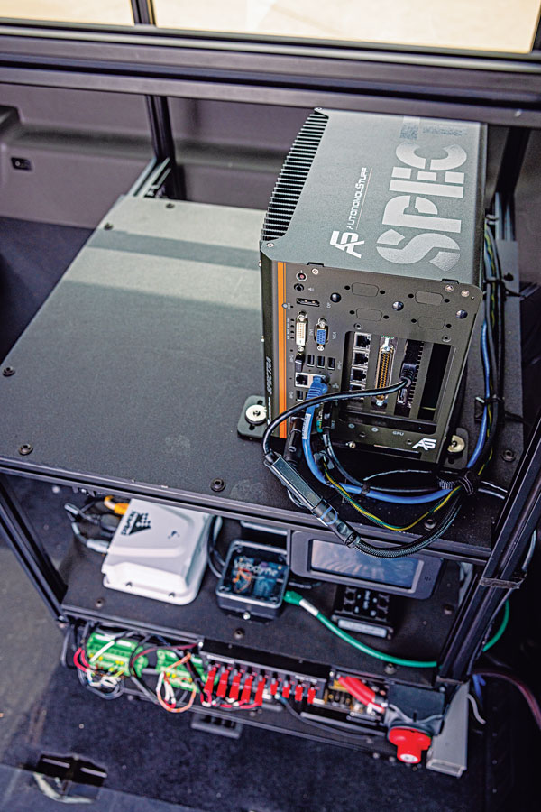
Hexagon | AutonomouStuff’s hardware rack inside the Ford Transit shuttle. (Photo: Hexagon | AutonomouStuff)
When it comes to ground transportation, most of the R&D regarding GNSS is aimed at developing driver-assist systems and, ultimately, driverless cars and trucks. For that purpose, GNSS receivers are integrated with inertial navigation systems, radar, lidar, computer vision and ultrasonics.
Leveraging decades of robotics experience and knowledge of control algorithms, AutonomouStuff, part of Hexagon’s Autonomy & Positioning division, has developed a software stack for autonomous vehicles based on the Apollo open-source software stack.
“Think of this software stack as a brain powering the autonomous platform,” said Kevin Fay, product manager for Hexagon’s platforms and vehicle software business. The software stack can be customized across platforms and to meet equipment needs.
Most recently, in a collaborative project with the National Advanced Driving Simulator at the University of Iowa, AutonomouStuff worked with the Automated Driving Systems for Rural America project to outfit a Ford Transit 350HD shuttle for autonomous operation. First, it created a drive-by-wire system that enabled electronic control of the vehicle, and then it installed positioning, navigation and perception sensors. The result is a platform ready to be autonomous as soon as the software stack is integrated.
Rural roads — which have a wider range of speeds than urban ones — may be encumbered by wildlife or heavy equipment. They also vary in surface from asphalt to gravel, providing a particularly challenging test environment for the autonomy software.
“The Iowa vehicle has done a sizable amount of automated driving on a combination of urban and rural roads, where traditional sensing falls flat,” Fay said. “It has excelled in areas such as gravel roads that have limited or no lane markings, or are narrower than normal. We deployed it earlier this year to do things such as traffic-light detection with the cameras on board, so that it navigates traffic-light intersections appropriately.”
While rural roads are generally free of the GNSS multipath challenges presented by urban canyons, they also provide fewer navigation landmarks. Another challenge is inclement weather. During snowstorms, Fay pointed out, country roads might be unplowed. “If you run on the right lane of the road all the time, you might be out of the ruts that are on the road, and then you’re struggling to get through.” The vehicle must learn to navigate appropriately in those conditions.
The University of Iowa Ford Transit shuttle is a limited deployment, mainly to collect data for research purposes. Meanwhile, it is giving real rides to residents, though with a safety driver. “They’re always attentive, but their hands will be next to the wheel,” Fay said. “There will be times where they may have to take over.”
Other universities and companies are using the platform to further their autonomy programs. Most of them are doing urban driving in complex routes with live traffic, for a total of a dozen vans nationwide.
Hexagon equips the vehicles with a variety of sensors, including a front-mounted adaptive radar, a roof-mounted Velodyne lidar, a roof-mounted NovAtel GNSS receiver and cameras mounted inside the vehicle. “Which ones we provide depends largely on the customer and on which software they’re deploying,” Fay said. “We provide our customers a complete package that can be used with minimal work out of the box. It has the software, the interface to the vehicle, and sensors on it. But we can also provide them with a vehicle that simply has an interface for control, and they add their own computer and software on top of it.”
Hexagon’s first Ford Transit was deployed in 2021. The company released the current version in the spring of 2022, and the Iowa project is slated to run through the middle of 2023. “We’ve not had something running in live traffic before,” Fay said, “so it allows us to continue to grow our skill sets and our overall expertise.”
Ola Rollén to be proposed as chairman of the board
Paolo Guglielmini, Hexagon
Hexagon AB has announced that Paolo Guglielmini will succeed Ola Rollén as president and CEO of Hexagon AB, effective Dec. 31.
Gun Nilsson has decided to step down as CEO for Hexagon’s principal shareholder MSAB on Oct. 1 and leave her position as chairman of Hexagon AB at the Annual General Meeting (AGM) 2023. MSAB, in consultation with Hexagon’s nomination committee, will propose Ola Rollén as new chairman of the board at the AGM 2023.
Guglielmini, currently Hexagon’s chief operating officer (COO) and president of Hexagon’s Manufacturing Intelligence (MI) division, has served in key roles since joining Hexagon in 2010, from strategy and business development to M&A and general management. He has been instrumental in expanding MI’s focus towards software-centric quality data solutions, and with his team driving the business towards all-time-high performance in 2021. Before joining Hexagon, Guglielmini held positions at CERN, the European Organization for Nuclear Research in Switzerland and Accenture. He holds a master of science in engineering and master of business administration from IMD.
”I’m happy that we have found an internal solution for my succession, which will bring long-term stability and continuity, but at the same time needed rejuvenation as we prepare this amazing company for the next big leap strategically,” Rollén said. “I have preoccupied myself with the well-being of Hexagon 24/7 for the last 22 years, and it’s a true privilege to be able to continue to follow the company’s successful development as chairman.”
“I’m honored by the opportunity to build upon the legacy that Ola and our team have created over the past two decades, and excited to lead Hexagon into the future,” Guglielmini said. “We are very well positioned to capitalize on the vast opportunities ahead, combining software, sensors and autonomous technologies to create sustainable value for our stakeholders.”
At the same time, the following organizational changes will be made:
Josh (Joshua) Weiss, currently COO of Hexagon Geosystems, will succeed Guglielmini as president for Hexagon Manufacturing Intelligence, effective July 1. Weiss has served in multiple leadership roles since joining Hexagon in 2015, from his most recent role to the president of Geosystems’ mining and heavy construction businesses. Weiss will report to Hexagon’s president and CEO and be a part of the Executive Management Team.
Michael Ritter, currently president of Hexagon Autonomy & Positioning, will assume a new senior role overseeing Hexagon’s Autonomy & Positioning, Mining and Agriculture divisions, effective immediately. In this role, Ritter will be responsible for leading the strategy of the businesses, to accelerate synergies and strengthening the solutions portfolio for Hexagon’s customers. Ritter will continue reporting to Hexagon’s president and CEO and be a part of the executive management team.
Maria Luthström, currently head of Sustainability and Investor Relations for Hexagon, will succeed Ritter as president of Hexagon Autonomy & Positioning, effective Oct. 1. Luthström joined Hexagon in 2015 and has been instrumental in expanding the company’s strategy and environmental, social and governance agenda, strengthening Hexagon’s culture and increasing shareholder value. Luthström will report to Michael Ritter.
Hexagon | NovAtel’s CPT7 integrates a GNSS receiver and an INS to deliver up to centimeter-level accuracy. (Photo: Hexagon | NovAtel)
We discussed mobile mapping with Bryan Leedham, product manager of enclosures and post-processing software, NovAtel, Autonomy & Positioning division, Hexagon.
How do you define mobile mapping?
It is getting broader in scope, as more folks find reasons to map the world. The key goal is to capture reality from mobile platforms to build a digital representation of reality for some large area, such as a city, a road or a factory. Most of the time, that means from a ground vehicle on public roads.
It’s also safer and faster than traditional surveying because you don’t have to stop traffic or dodge it.
Right! In an ideal world, rather than spending days setting up traditional survey equipment, you could strap some sensors on a mobile platform and gather accurate map data in minutes.
What are the key remaining technical challenges?
Picture one of Google’s or Waymo’s mapping vehicles. The first sensors that come to mind are GNSS, inertial, lidar and radar. Each of those has its own unique strengths and weaknesses. The first technical challenge that remains is to mature each of those technologies for a lower enough cost that it’s affordable.
Right now, mobile-mapping vehicles are quite expensive, especially in areas where some of these sensors will struggle more than others. To map very dense urban spaces — with underground areas, overpasses and tall buildings where GPS is challenged — you need a very strong localization system that can survive those conditions for however long it takes to drive through them. If I’m building a car to map rural Alberta, I could choose much cheaper sensors than if I were trying to map downtown Chicago every week.
On the flip side, you must deal with the massive amounts of data collected.
Yes, that is a very large challenge. Lidar data, in particular, is guilty of generating very large point clouds. It’s a balancing act. More accurate and higher resolution maps require lidar sensors with even denser point clouds. So, you need data management and sufficient processing power to get accurate results quickly.
What are the key technical challenges in sensor fusion?
Sensor fusion is how we approach the goal of mapping as accurately as possible in increasingly difficult environments. On their own, GNSS receivers struggle in obstructed areas but, when you pair them with other sensors, they become very complementary.
Lidar and cameras, for example, are quite good at measuring the distance to nearby objects and at classifying them, but they have no idea where they are relative to one another. Likewise, if you let an IMU [inertial measurement unit] sit in your car, it will no longer know its location. However, once you give it a position update, it is very good at maintaining a trajectory over a short period of time. When you combine absolute and relative localization, all the sensors play to their own strengths.
What is NovAtel’s SPAN software?
It stands for synchronous position, attitude and navigation. It is the sensor-fusion software that combines the GNSS, inertial and whatever other sensors. It is based on core NovAtel GNSS receiver software. We can use NovAtel receivers in combination with IMUs from a wide range of manufacturers and, in the future, hopefully, other sensors from a variety of manufacturers as well.
SPAN started with blending just GNSS and inertial but we’re now researching how to bring in such things as lidar and cameras. Autonomous Stuff, another Hexagon company, works on the greater sensor fusion using SPAN as well.
A mining road-train loaded with ore passes through an outback town. A Hexagon system will guide autonomous movement of similar heavy vehicles. Photo: BeyondImages/iStock/Getty Images Plus/Getty Images
Hexagon’s Autonomy & Positioning and Mining divisions recently partnered with Mineral Resources Limited (MRL), a mining services company, to develop an automated road-train solution for deployment on MRL’s haulage fleet over the next two years. The solution integrates drive-by-wire technology with an autonomous management system to orchestrate vehicle movement in road-train haulage to improve safety, productivity and sustainability. We asked Lee Baldwin, the director of Hexagon’s Autonomy & Positioning division, a few questions about the system.
What does an automated road-train do?
It is for haulage on roads hundreds of kilometers long. It first will be used to move ore from a mine processing facility in the Pilbara region of Western Australia, about 1,200 kilometers north of Perth, to Port Hedland, where it is loaded on ships bound for Asia for use in steel mills. Typically, this is done using either rail or a road train, which is a highway truck pulling multiple trailers. Today, a person drives a road train.
What motivated this project?
Mines have difficulty finding drivers for mining trucks and road trains because the mines are very far away from the nearest city, Perth, so they must fly workers in and out, which is very costly. Many of them are on 10-day shifts. Also, there are safety concerns.
How does an automated road-train work?
It requires three typical subsystems that you would have on any autonomous vehicle. The first one is positioning, including redundant GNSS receivers with our TerraStar correction services. The second is a perception system for collision avoidance, using our HxGN MineProtect Collision Avoidance System. The third one is route planning. We will start by platooning, with a driver in the first truck, which will be followed by three unmanned ones, each towing multiple trailers. Each truck will have the positioning, perception and route-planning systems. Later, we will achieve full autonomy by removing the driver from the lead vehicle.
How will the transfer at the mine work?
At a mine site, the road train will be commissioned in a sequestered area, then sent to a loading area where it will be loaded with ore, either automatically or by a manned wheel loader. Next, it will travel 200 kilometers to the port, where it will dump the ore. Finally, it will be decommissioned and queued up for the return journey.
Which parts are already in place and which ones are still being developed?
At Hexagon, we are already putting technology in manned mines. For example, we already have the collision-avoidance system, a fleet management system, and some sitewide planning systems. However, the trucks that the customers are choosing will have to be converted to be drive-by-wire to accommodate our autonomy system. They will use two PwrPak7 GNSS receivers and the TerraStar correction service.